
.gif)
Miya River (Mie)
Encyclopedia
The is a major river
that flows through central Mie Prefecture
on the island of Honshū
, Japan
. It is officially classified as a Class 1 river by the Japanese government and is one of four Class 1 rivers that flow solely through Mie; it is the longest among these four.
It is known to be especially pristine. In the government's annual water quality study, the Miya River has been rated the cleanest Class 1 river in the country five times since 2000.
The river's source is on Mount Ōdaigahara
in the town of Ōdai
, Mie Prefecture, where it flows through the Ōsugi Valley. It then flows northeast-wards down the mountains and passes through a number of dams before reaching the tea fields of central Mie and finally passes through the city of Ise
before reaching its delta and flowing into Ise Bay
.
The white rocks used in the Oshiraishi-mochi festival, an event held in honor of the periodic rebuilding of nearby Ise Grand Shrine, are taken from the Miya River's shores.
:
. Even with modern flood prevention, minor damage from flooding is still seen along parts of the river each year.
Flooding from the river was so severe in the past that it was one of the first rivers in Japan to receive a floodbank during the Edo era. The magistrate in Yamada (modern Ise) during the Tokugawa Shogunate
felt that the river needed to be controlled because of its proximity to Ise Grand Shrine, Japan's holiest shrine; he thus ordered work to be done along the river to alleviate the problem. These alterations, which were primarily done along the Yamada-side of the river, were effective in reducing flood damage on that side however increased flooding problems on the other side. Due to the changes made, a bridge across the river was not completed until the Meiji era.
The only significant flooding in recent history was the result of typhoon #21 in 2004, in which six people died. These deaths occurred in the former village of Miyagawa
, and this disaster was a prime factor behind the village being absorbed by the town of Ōdai soon after.
(unagi), Congridae
(anago), and sweetfish
(ayu).
 Other than fishing, the Miya River and its banks provides some recreational opportunities.
Near the source, the river flows through the Ōsugi Valley, which is officially listed as one of the top three ravines in Japan for sight-seeing.
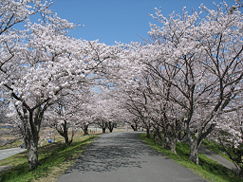
Further down the river, there are some parks along the riverbanks. There are cherry blossom parks in both Watarai and Ise, with the one in Ise having the most sakura trees in all of Mie. Many people have cherry blossom viewing parties
here during the blooming season in early April.
A large fireworks show is held each July at the park in Ise as well. Close to the mouth there is a park for sports, jogging, picnicking, and other recreation.
River
A river is a natural watercourse, usually freshwater, flowing towards an ocean, a lake, a sea, or another river. In a few cases, a river simply flows into the ground or dries up completely before reaching another body of water. Small rivers may also be called by several other names, including...
that flows through central Mie Prefecture
Mie Prefecture
is a prefecture of Japan which is part of the Kansai regions on Honshū island. The capital is the city of Tsu.- History :Until the Meiji Restoration, Mie prefecture was known as Ise Province and Iga Province....
on the island of Honshū
Honshu
is the largest island of Japan. The nation's main island, it is south of Hokkaido across the Tsugaru Strait, north of Shikoku across the Inland Sea, and northeast of Kyushu across the Kanmon Strait...
, Japan
Japan
Japan is an island nation in East Asia. Located in the Pacific Ocean, it lies to the east of the Sea of Japan, China, North Korea, South Korea and Russia, stretching from the Sea of Okhotsk in the north to the East China Sea and Taiwan in the south...
. It is officially classified as a Class 1 river by the Japanese government and is one of four Class 1 rivers that flow solely through Mie; it is the longest among these four.
It is known to be especially pristine. In the government's annual water quality study, the Miya River has been rated the cleanest Class 1 river in the country five times since 2000.
The river's source is on Mount Ōdaigahara
Mount Odaigahara
, also is a mountain in the Daikō Mountain Range and on the border between the prefectures of Mie and Nara, Japan. The mountain is the highest in Mie. In 1980 an area of 36,000 ha in the region of Mount Ōdaigahara and Mount Ōmine was designated a UNESCO Man and the Biosphere Reserve.- References :...
in the town of Ōdai
Odai, Mie
is a town located in Taki District, central Mie, on the island of Honshū, Japan.On January 10, 2006 the village of Miyagawa, from Taki District, was merged into Ōdai....
, Mie Prefecture, where it flows through the Ōsugi Valley. It then flows northeast-wards down the mountains and passes through a number of dams before reaching the tea fields of central Mie and finally passes through the city of Ise
Ise, Mie
, formerly called Ujiyamada , is a city located in eastern Mie Prefecture, on the island of Honshū, Japan.Ise is home to Ise Grand Shrine, the most sacred Shintō Shrine in Japan, and is thus a very popular destination for tourists. The city has a long-standing nickname—Shinto —that roughly means...
before reaching its delta and flowing into Ise Bay
Ise Bay
Ise Bay is a bay located at the mouth of the Kiso River between Mie and Aichi Prefectures in Japan. Ise Bay has an average depth of 19.5 metres and a maximum depth of 30 metres toward the centre. The mouth of the bay is 9 kilometres wide and is connected to the smaller Mikawa Bay by two channels:...
.
The white rocks used in the Oshiraishi-mochi festival, an event held in honor of the periodic rebuilding of nearby Ise Grand Shrine, are taken from the Miya River's shores.
Course
Mie PrefectureMie Prefecture
is a prefecture of Japan which is part of the Kansai regions on Honshū island. The capital is the city of Tsu.- History :Until the Meiji Restoration, Mie prefecture was known as Ise Province and Iga Province....
:
- ŌdaiOdai, Mieis a town located in Taki District, central Mie, on the island of Honshū, Japan.On January 10, 2006 the village of Miyagawa, from Taki District, was merged into Ōdai....
• TakiTaki, Mieis a town in Taki District, Mie, Japan.On January 1, 2006 the village of Seiwa, from Taki District, was merged into Taki.As of 2010 the town has an estimated population of 15,457 and a density of 150 persons per km²...
• TaikiTaiki, Mieis a town located in Watarai District, Mie, Japan. The town was formed on February 14, 2005 from the merger of the towns of Kisei and Ōmiya and the village of Ōuchiyama....
• WataraiWatarai, Mieis a town located in Watarai District, Mie, Japan.As of 2010, the town has an estimated population of 8,732 and a density of 64.7 persons per km². The total area is 134.97 km².-External links:*...
• TamakiTamaki, Mieis a town located in Watarai District, Mie, Japan.As of 2010, the town has an estimated population of 15,268 and a density of 373 persons per km². The total area is 40.94 km²....
• IseIse, Mie, formerly called Ujiyamada , is a city located in eastern Mie Prefecture, on the island of Honshū, Japan.Ise is home to Ise Grand Shrine, the most sacred Shintō Shrine in Japan, and is thus a very popular destination for tourists. The city has a long-standing nickname—Shinto —that roughly means...
Flooding
Some of the areas along the river's course, especially the Ōsugi Valley near the source, see a considerable amount of rain each year and thus it is very prone to floodingFlood
A flood is an overflow of an expanse of water that submerges land. The EU Floods directive defines a flood as a temporary covering by water of land not normally covered by water...
. Even with modern flood prevention, minor damage from flooding is still seen along parts of the river each year.
Flooding from the river was so severe in the past that it was one of the first rivers in Japan to receive a floodbank during the Edo era. The magistrate in Yamada (modern Ise) during the Tokugawa Shogunate
Tokugawa shogunate
The Tokugawa shogunate, also known as the and the , was a feudal regime of Japan established by Tokugawa Ieyasu and ruled by the shoguns of the Tokugawa family. This period is known as the Edo period and gets its name from the capital city, Edo, which is now called Tokyo, after the name was...
felt that the river needed to be controlled because of its proximity to Ise Grand Shrine, Japan's holiest shrine; he thus ordered work to be done along the river to alleviate the problem. These alterations, which were primarily done along the Yamada-side of the river, were effective in reducing flood damage on that side however increased flooding problems on the other side. Due to the changes made, a bridge across the river was not completed until the Meiji era.
The only significant flooding in recent history was the result of typhoon #21 in 2004, in which six people died. These deaths occurred in the former village of Miyagawa
Miyagawa, Mie
was a village located in Taki District, Mie, Japan.On January 10, 2006 Miyagawa was merged into the expanded town of Ōdai and no longer exists as an independent municipality....
, and this disaster was a prime factor behind the village being absorbed by the town of Ōdai soon after.
Wildlife
The Miya River is home to over 90 different species of wildlife. There are fishing operations for some of the more prevalent ones, including eelJapanese eel
The Japanese eel, Anguilla japonica, is a species of eel found in Japan, Korea, Vietnam the East China Sea and the northern Philippines. Like the all the eels of its family, it is catadromous, meaning it lives parts of its life in both freshwater and saltwater. The specific spawning grounds have...
(unagi), Congridae
Congridae
Congridae is the family of conger and garden eels. Congers are valuable and often large food fishes, while garden eels live in colonies, all protruding from the sea floor after the manner of plants in a garden...
(anago), and sweetfish
Ayu
The or sweetfish, Plecoglossus altivelis, is an amphidromous fish, the only species in the genus Plecoglossus and in family Plecoglossidae. It is a relative of the smelts and is placed in the order Osmeriformes...
(ayu).
Recreation
Near the source, the river flows through the Ōsugi Valley, which is officially listed as one of the top three ravines in Japan for sight-seeing.
Further down the river, there are some parks along the riverbanks. There are cherry blossom parks in both Watarai and Ise, with the one in Ise having the most sakura trees in all of Mie. Many people have cherry blossom viewing parties
Hanami
is the Japanese traditional custom of enjoying the beauty of flowers, "flower" in this case almost always meaning cherry blossoms or ume blossoms. From the end of March to early May, sakura bloom all over Japan, and around the first of February on the island of Okinawa...
here during the blooming season in early April.
A large fireworks show is held each July at the park in Ise as well. Close to the mouth there is a park for sports, jogging, picnicking, and other recreation.