
Ise Bay
Encyclopedia
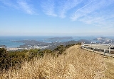
Ise Bay is a bay located at the mouth of the Kiso River
between Mie
and Aichi
Prefectures in Japan. Ise Bay has an average depth of 19.5 metres and a maximum depth of 30 metres toward the centre. The mouth of the bay is 9 kilometres wide and is connected to the smaller Mikawa Bay
by two channels: the Nakayama Channel and the Morosaki Channel. Mikawa Bay is subsequently joined to the Philippine Sea
by the Irako Channel, which ranges from 50 to 100 metres in depth.
, where the shrine stands. The flat coastal plain that stretches from Kuwana
in northern Mie Prefecture
to Ise is called the Ise Plain and this plain lies on the western shore of Ise Bay. Prior to the Meiji Period
, Ise Province
consisted of most of modern Mie Prefecture.
From ancient times, Ise Bay has provided the people of the surrounding regions with a rich abundance of natural resources as well as providing easy transport. As a result, unique communities developed around the bay and fishing (including Ise Ebi), pearl farming
, rice crops, and manufacturing industries flourished. Nagoya Port
, located on the northern shore of Ise Bay, is the largest trading port in Japan. Chubu Centrair International Airport
, built on an artificial island
in the bay, was opened in 2005 to serve the region.
After the end of the Second World War, the Ise Bay region contributed greatly to the rapid recovery of the Japanese economy. This rapid expansion of large industry has come at a cost, though, with pollution affecting the water quality and with landfills and the like reducing the number of tidelands, seaweed beds, and other areas vital in preserving the habitat of local flora and fauna. Sea walls built to protect human habitation, particularly after the 1959 Ise-wan Typhoon, have left more and more areas virtually cut off from the sea.
Ise Bay also has three active earthquake fault lines: Ise Bay fault, Suzuka-oki fault and the Shiroko-noma fault.
Kiso River
The is a river in Japan roughly 193 km long, flowing through the prefectures of Nagano, Gifu, Aichi, and Mie before emptying into Ise Bay a short distance away from the city of Nagoya. It is the main river of the Kiso Three Rivers and forms a major part of the Nōbi Plain...
between Mie
Mie Prefecture
is a prefecture of Japan which is part of the Kansai regions on Honshū island. The capital is the city of Tsu.- History :Until the Meiji Restoration, Mie prefecture was known as Ise Province and Iga Province....
and Aichi
Aichi Prefecture
is a prefecture of Japan located in the Chūbu region. The region of Aichi is also known as the Tōkai region. The capital is Nagoya. It is the focus of the Chūkyō Metropolitan Area.- History :...
Prefectures in Japan. Ise Bay has an average depth of 19.5 metres and a maximum depth of 30 metres toward the centre. The mouth of the bay is 9 kilometres wide and is connected to the smaller Mikawa Bay
Mikawa Bay
thumb|right|Mikawa Bay Mikawa Bay is a bay to the south of Aichi Prefecture, Japan, surrounded by Chita Peninsula to the west and Atsumi Peninsula to the east and south. Its area is approximately 604 km2...
by two channels: the Nakayama Channel and the Morosaki Channel. Mikawa Bay is subsequently joined to the Philippine Sea
Philippine Sea
The Philippine Sea is a marginal sea east and north of the Philippines occupying an estimated surface area of 2 million mi² on the western part of the North Pacific Ocean...
by the Irako Channel, which ranges from 50 to 100 metres in depth.
History and Environment
Ise Bay derives its name from the region surrounding Ise Grand Shrine and the city of IseIse, Mie
, formerly called Ujiyamada , is a city located in eastern Mie Prefecture, on the island of Honshū, Japan.Ise is home to Ise Grand Shrine, the most sacred Shintō Shrine in Japan, and is thus a very popular destination for tourists. The city has a long-standing nickname—Shinto —that roughly means...
, where the shrine stands. The flat coastal plain that stretches from Kuwana
Kuwana, Mie
is a city located in the northern end of Mie Prefecture, Japan. It is known as a major sightseeing city in the prefecture. Located at the mouth of the three rivers dividing Mie and Aichi prefectures, the city has functioned as a regional center of fishing, industry, business, and culture.As of...
in northern Mie Prefecture
Mie Prefecture
is a prefecture of Japan which is part of the Kansai regions on Honshū island. The capital is the city of Tsu.- History :Until the Meiji Restoration, Mie prefecture was known as Ise Province and Iga Province....
to Ise is called the Ise Plain and this plain lies on the western shore of Ise Bay. Prior to the Meiji Period
Meiji period
The , also known as the Meiji era, is a Japanese era which extended from September 1868 through July 1912. This period represents the first half of the Empire of Japan.- Meiji Restoration and the emperor :...
, Ise Province
Ise Province
or was a province of Japan including most of modern Mie Prefecture. Ise bordered Iga, Kii, Mino, Ōmi, Owari, Shima, and Yamato Provinces.The ancient provincial capital was at Suzuka...
consisted of most of modern Mie Prefecture.
From ancient times, Ise Bay has provided the people of the surrounding regions with a rich abundance of natural resources as well as providing easy transport. As a result, unique communities developed around the bay and fishing (including Ise Ebi), pearl farming
Cultured pearl
A cultured pearl is a pearl created by a pearl farmer under controlled conditions.-Development of a pearl:A pearl is formed when the mantle tissue is injured by a parasite, an attack of a fish or another event that damages the external fragile rim of the shell of a molluc shell bivalve or gastropod...
, rice crops, and manufacturing industries flourished. Nagoya Port
Nagoya Port
The , located in Ise Bay, is the largest and busiest trading port in Japan, accounting for about 10% of the total trade value of Japan. Notably, this port is the largest exporter of cars in Japan and where the Toyota Motor Corporation exports most of its cars...
, located on the northern shore of Ise Bay, is the largest trading port in Japan. Chubu Centrair International Airport
Chubu Centrair International Airport
is an airport on an artificial island in Ise Bay, Tokoname City in Aichi Prefecture, south of Nagoya in central Japan.Centrair is classified as a first class airport and is the main international gateway for the Chūbu region of Japan...
, built on an artificial island
Artificial island
An artificial island or man-made island is an island or archipelago that has been constructed by people rather than formed by natural means...
in the bay, was opened in 2005 to serve the region.
After the end of the Second World War, the Ise Bay region contributed greatly to the rapid recovery of the Japanese economy. This rapid expansion of large industry has come at a cost, though, with pollution affecting the water quality and with landfills and the like reducing the number of tidelands, seaweed beds, and other areas vital in preserving the habitat of local flora and fauna. Sea walls built to protect human habitation, particularly after the 1959 Ise-wan Typhoon, have left more and more areas virtually cut off from the sea.
Ise Bay also has three active earthquake fault lines: Ise Bay fault, Suzuka-oki fault and the Shiroko-noma fault.