
Mittlerer Erzgebirgskreis
Encyclopedia
The Mittlerer Erzgebirgskreis is a former district in the Free State of Saxony, Germany
. It was bounded by (from the west and clockwise) the districts of Annaberg
, Stollberg
, the district-free city Chemnitz
, and the district Freiberg
. To the south it borders the Czech Republic
(the Karlovy Vary Region).
.
Erzgebirge). The highest elevation is the 891 m high Hirtstein, the lowest elevation with 305 m is located in Witzschdorf. 40% of the area is covered by forests.
Germany
Germany , officially the Federal Republic of Germany , is a federal parliamentary republic in Europe. The country consists of 16 states while the capital and largest city is Berlin. Germany covers an area of 357,021 km2 and has a largely temperate seasonal climate...
. It was bounded by (from the west and clockwise) the districts of Annaberg
Annaberg
Annaberg is a former district in the Free State of Saxony, Germany. It was bounded by the Czech Republic and the districts of Aue-Schwarzenberg, Stollberg and Mittlerer Erzgebirgskreis. Its national colors are pink, green, and blue.- History :In the Middle Ages the Ore Mountains were virtually...
, Stollberg
Stollberg (district)
Stollberg is a former district in the Free State of Saxony, Germany. It was bounded by the district-free city Chemnitz, and the districts Mittlerer Erzgebirgskreis, Annaberg, Aue-Schwarzenberg, Zwickauer Land and Chemnitzer Land....
, the district-free city Chemnitz
Chemnitz
Chemnitz is the third-largest city of the Free State of Saxony, Germany. Chemnitz is an independent city which is not part of any county and seat of the government region Direktionsbezirk Chemnitz. Located in the northern foothills of the Ore Mountains, it is a part of the Saxon triangle...
, and the district Freiberg
Freiberg (district)
Freiberg is a former district in the Free State of Saxony, Germany. It was bounded by the district of Mittlerer Erzgebirgskreis, the city of Chemnitz, the districts of Mittweida, Meißen and Weißeritzkreis, and by the Czech Republic.- History :The district was established in 1994 by merging the...
. To the south it borders the Czech Republic
Czech Republic
The Czech Republic is a landlocked country in Central Europe. The country is bordered by Poland to the northeast, Slovakia to the east, Austria to the south, and Germany to the west and northwest....
(the Karlovy Vary Region).
History
The district was formed in 1994 by merging the two previous districts Marienberg and Zschopau. On 1 August 2008 it was merged into the new district ErzgebirgskreisErzgebirgskreis
Erzgebirgskreis is a district in the Free State of Saxony, Germany. It is named after the Erzgebirge , a mountain range in the southern part of the district which forms part of the Germany–Czech Republic border...
.
Geography
The district was located in the Ore Mountains (GermanGerman language
German is a West Germanic language, related to and classified alongside English and Dutch. With an estimated 90 – 98 million native speakers, German is one of the world's major languages and is the most widely-spoken first language in the European Union....
Erzgebirge). The highest elevation is the 891 m high Hirtstein, the lowest elevation with 305 m is located in Witzschdorf. 40% of the area is covered by forests.
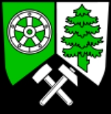
Coat of arms
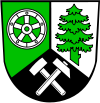 |
The coat of arms shows three symbols of the typical industries of the district. To the left is a wheel, symbolizing the water mills which were abundant in the district, it also symbolizes the more modern industries. The tree to the left stands for the many forests and the timber industry, the hammers in the bottom are a mining symbol, as the district was a center of ore mining. |
Towns and municipalities
| Towns | Municipalities | |
|---|---|---|
|
Börnichen - References :... Borstendorf Borstendorf is a municipality in the district Erzgebirgskreis, in Saxony, Germany.... Deutschneudorf Deutschneudorf is a municipality in the district Erzgebirgskreis, in Saxony, Germany.Deutschneudorf is also the site of a recent dig in search of Nazi gold. This site, an abandoned copper mine in the Ore mountains, was identified by radar scans as having a large amount of dense metal... Drebach Drebach is a municipality in the district of Erzgebirgskreis, in Saxony, Germany.... Gornau -Subdivisions:Gornau has three subdivisions:*Gornau*Dittmannsdorf*WitzschdorfGornau is a municipality in the district Erzgebirgskreis, in Saxony, Germany.-Municipal Council:The local council of Gornau has 16 seats... Großolbersdorf Großolbersdorf is a municipality in the district Erzgebirgskreis in Saxony, Germany.- References :... Großrückerswalde Großrückerswalde is a municipality in the district Erzgebirgskreis, in Saxony, Germany.- References :... |
|
External links
- Official website (German)
- Touristical website (German)