

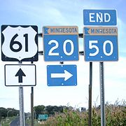
Minnesota State Highway 20
Encyclopedia
Minnesota State Highway 20 is a short highway
in southeast Minnesota
, which runs from its intersection
with State Highway 19
in Cannon Falls
(near U.S. 52
) and continues north to its northern terminus at its intersection with State Highway 50
near Miesville
, 400 feet west of U.S. 61
.
Highway 20 is 7.5 miles (12.1 km) in length and passes through the city of Cannon Falls
and Douglas Township.
and State Highway 50
near Miesville
. Its northern terminus is 400 feet west of Highway 50's junction with U.S. 61.
Highway 20 is also known as:
The route crosses the Cannon River in the city of Cannon Falls.
There are no signs at the Highway 19
exit from U.S. 52
at Cannon Falls that indicate the short connection via Highway 19 to Highway 20, though at the end of the offramps the connection is indicated.
to its current northern terminus. U.S. Route 55
was established in 1927 along this road from the Iowa border to Cannon Falls. When U.S. Route 52
was extended into Minnesota in 1934 to replace U.S. 55, the Highway 20 designation was removed from this portion of the highway, leaving only the section that remains today.
The route was paved by 1940.
Highway
A highway is any public road. In American English, the term is common and almost always designates major roads. In British English, the term designates any road open to the public. Any interconnected set of highways can be variously referred to as a "highway system", a "highway network", or a...
in southeast Minnesota
Minnesota
Minnesota is a U.S. state located in the Midwestern United States. The twelfth largest state of the U.S., it is the twenty-first most populous, with 5.3 million residents. Minnesota was carved out of the eastern half of the Minnesota Territory and admitted to the Union as the thirty-second state...
, which runs from its intersection
Intersection (road)
An intersection is a road junction where two or more roads either meet or cross at grade . An intersection may be 3-way - a T junction or fork, 4-way - a crossroads, or 5-way or more...
with State Highway 19
Minnesota State Highway 19
Minnesota State Highway 19 is a highway in southwest and southeast Minnesota, which runs from South Dakota Highway 30 at the South Dakota state line near Ivanhoe and continues east to its eastern terminus at its intersection with U.S...
in Cannon Falls
Cannon Falls, Minnesota
As of the census of 2000, there were 3,795 people, 1,550 households, and 996 families residing in the city. The population density was 946.4 people per square mile . There were 1,611 housing units at an average density of 401.8 per square mile...
(near U.S. 52
U.S. Route 52 in Minnesota
U.S. Highway 52 enters the state of Minnesota at the unincorporated community of Prosper, north of the town of Burr Oak, Iowa. The route is marked north–south in Minnesota along its independent segment from the Iowa state line to downtown St. Paul...
) and continues north to its northern terminus at its intersection with State Highway 50
Minnesota State Highway 50
Minnesota State Highway 50 is a highway in Minnesota, which runs from its intersection with State Highway 3 and Dakota County Road 74 in Farmington and continues east to its eastern terminus at its intersection with U.S...
near Miesville
Miesville, Minnesota
Miesville is a city in Dakota County, Minnesota, United States. The population was 125 at the 2010 census.U.S. Highway 61 serves as a main route in the community...
, 400 feet west of U.S. 61
U.S. Route 61 in Minnesota
U.S. Highway 61 is a highway in southeast and east-central Minnesota, which runs from the River Bridge over the Mississippi River at La Crescent and continues north to its northern terminus at its junction with Interstate 35 at the city of Wyoming....
.
Highway 20 is 7.5 miles (12.1 km) in length and passes through the city of Cannon Falls
Cannon Falls, Minnesota
As of the census of 2000, there were 3,795 people, 1,550 households, and 996 families residing in the city. The population density was 946.4 people per square mile . There were 1,611 housing units at an average density of 401.8 per square mile...
and Douglas Township.
Route description
Highway 20 serves as a north–south route between Cannon FallsCannon Falls, Minnesota
As of the census of 2000, there were 3,795 people, 1,550 households, and 996 families residing in the city. The population density was 946.4 people per square mile . There were 1,611 housing units at an average density of 401.8 per square mile...
and State Highway 50
Minnesota State Highway 50
Minnesota State Highway 50 is a highway in Minnesota, which runs from its intersection with State Highway 3 and Dakota County Road 74 in Farmington and continues east to its eastern terminus at its intersection with U.S...
near Miesville
Miesville, Minnesota
Miesville is a city in Dakota County, Minnesota, United States. The population was 125 at the 2010 census.U.S. Highway 61 serves as a main route in the community...
. Its northern terminus is 400 feet west of Highway 50's junction with U.S. 61.
Highway 20 is also known as:
- 4th Street N and 5th Street N in Cannon FallsCannon Falls, MinnesotaAs of the census of 2000, there were 3,795 people, 1,550 households, and 996 families residing in the city. The population density was 946.4 people per square mile . There were 1,611 housing units at an average density of 401.8 per square mile...
- Cannon Falls Boulevard in southeast Dakota CountyDakota County, MinnesotaDakota County is the third most populous county in the U.S. state of Minnesota. The county is bordered by the Minnesota and Mississippi Rivers on the north, and the state of Wisconsin on the east. Dakota County comprises the southeast portion of seven-county Minneapolis-St. Paul, the thirteenth...
The route crosses the Cannon River in the city of Cannon Falls.
There are no signs at the Highway 19
Minnesota State Highway 19
Minnesota State Highway 19 is a highway in southwest and southeast Minnesota, which runs from South Dakota Highway 30 at the South Dakota state line near Ivanhoe and continues east to its eastern terminus at its intersection with U.S...
exit from U.S. 52
U.S. Route 52 in Minnesota
U.S. Highway 52 enters the state of Minnesota at the unincorporated community of Prosper, north of the town of Burr Oak, Iowa. The route is marked north–south in Minnesota along its independent segment from the Iowa state line to downtown St. Paul...
at Cannon Falls that indicate the short connection via Highway 19 to Highway 20, though at the end of the offramps the connection is indicated.
History
Highway 20 was designated and signed in 1920 from the Iowa border near CantonCanton, Minnesota
Canton is a city in Fillmore County, Minnesota, United States. The population was 346 at the 2010 census.-Geography:According to the United States Census Bureau, the city has a total area of , all of it land.-Demographics:...
to its current northern terminus. U.S. Route 55
U.S. Route 55
U.S. Route 55 was a north–south United States highway. Despite the "5" in its route number, US 55 was never a long route. Though it was part of the original 1926 numbering plan, it was deleted within 10 years.-Route description:...
was established in 1927 along this road from the Iowa border to Cannon Falls. When U.S. Route 52
U.S. Route 52
U.S. Route 52 is a United States highway that runs across the northern, eastern and southeastern regions of the United States. Contrary to most other even-numbered U.S...
was extended into Minnesota in 1934 to replace U.S. 55, the Highway 20 designation was removed from this portion of the highway, leaving only the section that remains today.
The route was paved by 1940.