
Milton, Delaware
Encyclopedia
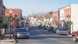
Milton is a town in Sussex County
, Delaware
, in the United States
. The population was 2,576 at the 2010 census
, an increase of 55.5% over the previous decade. It is part of the Seaford, Delaware
Micropolitan Statistical Area. Delaware Route 5
passes through Milton.
, Milton was first settled in 1672 by English Colonists. The town was known by various names until 1807, when it was named for the English poet, John Milton
. The Delaware General Assembly passed the charter that recognized The Town of Milton as a municipality in 1945.
History and Milton's shipbuilding heritage remain very important to the town, which is home to some of the finest Victorian and Colonial architecture in Delaware. Many of the homes have been restored to their original form, particularly those on Union and Federal streets.
Milton has 198 structures on the Federal Register Historic District
and its history is preserved in the Lydia Black Cannon Museum, the Governor James Carey home, the Chestnut Street Cemetery, and the Governor David Hazzard
Mansion.
Today, Milton serves local residents and summer tourists in the Milton, Broadkill Beach and Primehook Beach areas with family operated businesses and new office and shopping complexes.
Milton boasts numerous community organizations, a civic center, a memorial park, a volunteer fire department, a public library, more than a half-dozen major annual events, and churches.
Recreational opportunities abound with the Broadkill River
, Wagamon's Pond, Diamond Pond and Lavinia Pond. Public boat docks and fishing piers are also available.
.
According to the United States Census Bureau
, the town has a total area of 1.2 square miles (3.1 km²), of which, 1.1 square miles (2.8 km²) of it is land and 0.1 square mile (0.258998811 km²) of it (8.62%) is water.
of 2000, there were 1,657 people, 700 households, and 438 families residing in the town. The population density
was 1,568.5 people per square mile (603.6/km²). There were 804 housing units at an average density of 761.1 per square mile (292.9/km²). The racial makeup of the town was 67.11% White, 24.32% African American, 0.24% Native American, 0.48% Asian, 0.12% Pacific Islander, 6.04% from other races
, and 1.69% from two or more races. Hispanic or Latino of any race were 8.93% of the population.
There were 700 households out of which 31.4% had children under the age of 18 living with them, 37.3% were married couples
living together, 20.1% had a female householder with no husband present, and 37.4% were non-families. 31.3% of all households were made up of individuals and 17.4% had someone living alone who was 65 years of age or older. The average household size was 2.33 and the average family size was 2.90.
In the town the population was spread out with 24.6% under the age of 18, 10.2% from 18 to 24, 26.4% from 25 to 44, 22.0% from 45 to 64, and 16.8% who were 65 years of age or older. The median age was 37 years. For every 100 females there were 78.7 males. For every 100 females age 18 and over, there were 71.8 males.
The median income for a household in the town was $32,368, and the median income for a family was $40,313. Males had a median income of $26,065 versus $23,269 for females. The per capita income
for the town was $17,016. About 12.8% of families and 18.0% of the population were below the poverty line, including 28.6% of those under age 18 and 14.0% of those age 65 or over.
Sussex County, Delaware
Sussex County is a county located in the southern part of the U.S. state of Delaware. As of 2010 the population was 197,145, an increase of 25.9% over the previous decade. The county seat is Georgetown. The Seaford Micropolitan Statistical Area includes all of Sussex County.Sussex County is...
, Delaware
Delaware
Delaware is a U.S. state located on the Atlantic Coast in the Mid-Atlantic region of the United States. It is bordered to the south and west by Maryland, and to the north by Pennsylvania...
, in the United States
United States
The United States of America is a federal constitutional republic comprising fifty states and a federal district...
. The population was 2,576 at the 2010 census
United States Census, 2010
The Twenty-third United States Census, known as Census 2010 or the 2010 Census, is the current national census of the United States. National Census Day was April 1, 2010 and is the reference date used in enumerating individuals...
, an increase of 55.5% over the previous decade. It is part of the Seaford, Delaware
Seaford, Delaware
Seaford is a city located along the Nanticoke River in Sussex County, Delaware. According to the 2010 Census Bureau figures, the population of the city is 6,928, an increase of 3.4% from the 2000 census...
Micropolitan Statistical Area. Delaware Route 5
Delaware Route 5
Delaware Route 5 is a state highway in Sussex County, Delaware. The route runs north from the Indian River Bay in Oak Orchard north to Delaware Route 1 north of Milton. Along the way, DE 5 passes through Long Neck, Harbeson, and Milton. The route has concurrencies with Delaware Route 23 and...
passes through Milton.
History
Located at the head of the Broadkill RiverBroadkill River
The Broadkill River is a river flowing to Delaware Bay in southern Delaware in the United States. It is 13.3 miles long and drains an area of 110 square miles on the Atlantic Coastal Plain....
, Milton was first settled in 1672 by English Colonists. The town was known by various names until 1807, when it was named for the English poet, John Milton
John Milton
John Milton was an English poet, polemicist, a scholarly man of letters, and a civil servant for the Commonwealth of England under Oliver Cromwell...
. The Delaware General Assembly passed the charter that recognized The Town of Milton as a municipality in 1945.
History and Milton's shipbuilding heritage remain very important to the town, which is home to some of the finest Victorian and Colonial architecture in Delaware. Many of the homes have been restored to their original form, particularly those on Union and Federal streets.
Milton has 198 structures on the Federal Register Historic District
Historic district (United States)
In the United States, a historic district is a group of buildings, properties, or sites that have been designated by one of several entities on different levels as historically or architecturally significant. Buildings, structures, objects and sites within a historic district are normally divided...
and its history is preserved in the Lydia Black Cannon Museum, the Governor James Carey home, the Chestnut Street Cemetery, and the Governor David Hazzard
David Hazzard
David Hazzard was an American merchant and politician from Milton, in Sussex County, Delaware. He was a member of the Democratic-Republican Party, then the National Republican Party, and finally the Whig Party...
Mansion.
Today, Milton serves local residents and summer tourists in the Milton, Broadkill Beach and Primehook Beach areas with family operated businesses and new office and shopping complexes.
Milton boasts numerous community organizations, a civic center, a memorial park, a volunteer fire department, a public library, more than a half-dozen major annual events, and churches.
Recreational opportunities abound with the Broadkill River
Broadkill River
The Broadkill River is a river flowing to Delaware Bay in southern Delaware in the United States. It is 13.3 miles long and drains an area of 110 square miles on the Atlantic Coastal Plain....
, Wagamon's Pond, Diamond Pond and Lavinia Pond. Public boat docks and fishing piers are also available.
Geography
Milton is located at 38°46′48"N 75°18′46"W (38.779873, -75.312827), along the Broadkill RiverBroadkill River
The Broadkill River is a river flowing to Delaware Bay in southern Delaware in the United States. It is 13.3 miles long and drains an area of 110 square miles on the Atlantic Coastal Plain....
.
According to the United States Census Bureau
United States Census Bureau
The United States Census Bureau is the government agency that is responsible for the United States Census. It also gathers other national demographic and economic data...
, the town has a total area of 1.2 square miles (3.1 km²), of which, 1.1 square miles (2.8 km²) of it is land and 0.1 square mile (0.258998811 km²) of it (8.62%) is water.
Demographics
As of the censusCensus
A census is the procedure of systematically acquiring and recording information about the members of a given population. It is a regularly occurring and official count of a particular population. The term is used mostly in connection with national population and housing censuses; other common...
of 2000, there were 1,657 people, 700 households, and 438 families residing in the town. The population density
Population density
Population density is a measurement of population per unit area or unit volume. It is frequently applied to living organisms, and particularly to humans...
was 1,568.5 people per square mile (603.6/km²). There were 804 housing units at an average density of 761.1 per square mile (292.9/km²). The racial makeup of the town was 67.11% White, 24.32% African American, 0.24% Native American, 0.48% Asian, 0.12% Pacific Islander, 6.04% from other races
Race (United States Census)
Race and ethnicity in the United States Census, as defined by the Federal Office of Management and Budget and the United States Census Bureau, are self-identification data items in which residents choose the race or races with which they most closely identify, and indicate whether or not they are...
, and 1.69% from two or more races. Hispanic or Latino of any race were 8.93% of the population.
There were 700 households out of which 31.4% had children under the age of 18 living with them, 37.3% were married couples
Marriage
Marriage is a social union or legal contract between people that creates kinship. It is an institution in which interpersonal relationships, usually intimate and sexual, are acknowledged in a variety of ways, depending on the culture or subculture in which it is found...
living together, 20.1% had a female householder with no husband present, and 37.4% were non-families. 31.3% of all households were made up of individuals and 17.4% had someone living alone who was 65 years of age or older. The average household size was 2.33 and the average family size was 2.90.
In the town the population was spread out with 24.6% under the age of 18, 10.2% from 18 to 24, 26.4% from 25 to 44, 22.0% from 45 to 64, and 16.8% who were 65 years of age or older. The median age was 37 years. For every 100 females there were 78.7 males. For every 100 females age 18 and over, there were 71.8 males.
The median income for a household in the town was $32,368, and the median income for a family was $40,313. Males had a median income of $26,065 versus $23,269 for females. The per capita income
Per capita income
Per capita income or income per person is a measure of mean income within an economic aggregate, such as a country or city. It is calculated by taking a measure of all sources of income in the aggregate and dividing it by the total population...
for the town was $17,016. About 12.8% of families and 18.0% of the population were below the poverty line, including 28.6% of those under age 18 and 14.0% of those age 65 or over.