

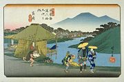
Mikuni Kaido
Encyclopedia
was an ancient highway in Japan
that stretched from Takasaki-juku (present day Gunma Prefecture
) on the Nakasendō
to Teradomari-juku (present day Niigata Prefecture
) on the Hokuriku Kaidō.
from Echigo Province
in ancient Japan. As such, it has long been used as a major transportation hub for travelers going betwee those two areas. During the Edo period
, the Mikuni Kaidō was established with the purpose of helping daimyō
who were participating in sankin kōtai
, which required daimyō to spend a portion of their time in Edo
.
In 1902, the Shin'etsu Main Line
was built, the first train line through the area. As a result, the economies of many of the post towns began to falter. However, the area between Nagaoka
and Yuzawa
was able to continue to flourish because the flat land allowed them to pursue agriculture. The area across the Mikuni Pass, however, received very little traffic.
In 1953, as cars became more common, so did long-distance transport, which lead to a great rise in traffic in the area. However, for cars traveling between the Kantō and Echigo regions, it was very inconvenient to take the same detour as the train line, so the prefecture began major repair and construction work along the Mikuni Kaidō.
or the Jōetsu Shinkansen
that stretch from the Kantō region to Niigata.
Japan
Japan is an island nation in East Asia. Located in the Pacific Ocean, it lies to the east of the Sea of Japan, China, North Korea, South Korea and Russia, stretching from the Sea of Okhotsk in the north to the East China Sea and Taiwan in the south...
that stretched from Takasaki-juku (present day Gunma Prefecture
Gunma Prefecture
is a prefecture of Japan located in the northwest corner of the Kantō region on Honshu island. Its capital is Maebashi.- History :The remains of a Paleolithic man were found at Iwajuku, Gunma Prefecture, in the early 20th century and there is a public museum there.Japan was without horses until...
) on the Nakasendō
Nakasendo
The , also called the , was one of the five routes of the Edo period, and one of the two that connected Edo to Kyoto in Japan. There were 69 stations between Edo and Kyoto, crossing through Musashi, Kōzuke, Shinano, Mino and Ōmi provinces...
to Teradomari-juku (present day Niigata Prefecture
Niigata Prefecture
is a prefecture of Japan located on the island of Honshū on the coast of the Sea of Japan. The capital is the city of Niigata. The name "Niigata" literally means "new lagoon".- History :...
) on the Hokuriku Kaidō.
History
The Mikuni Pass separated the Kantō regionKanto region
The is a geographical area of Honshu, the largest island of Japan. The region includes the Greater Tokyo Area and encompasses seven prefectures: Gunma, Tochigi, Ibaraki, Saitama, Tokyo, Chiba, and Kanagawa. Within its boundaries, slightly more than 40 percent of the land area is the Kantō Plain....
from Echigo Province
Echigo Province
was an old province in north-central Japan, on the shores of the Sea of Japan. It was sometimes called , with Echizen and Etchū Provinces. Today the area is part of Niigata Prefecture, which also includes the island which was the old Sado Province. This province was the northernmost part of the...
in ancient Japan. As such, it has long been used as a major transportation hub for travelers going betwee those two areas. During the Edo period
Edo period
The , or , is a division of Japanese history which was ruled by the shoguns of the Tokugawa family, running from 1603 to 1868. The political entity of this period was the Tokugawa shogunate....
, the Mikuni Kaidō was established with the purpose of helping daimyō
Daimyo
is a generic term referring to the powerful territorial lords in pre-modern Japan who ruled most of the country from their vast, hereditary land holdings...
who were participating in sankin kōtai
Sankin kotai
was a policy of the shogunate during most of the Edo period of Japanese history. The purpose was to control the daimyo. In adopting the policy, the shogunate was continuing and refining similar policies of Toyotomi Hideyoshi. In 1635, a law required sankin kōtai, which was already an established...
, which required daimyō to spend a portion of their time in Edo
Edo
, also romanized as Yedo or Yeddo, is the former name of the Japanese capital Tokyo, and was the seat of power for the Tokugawa shogunate which ruled Japan from 1603 to 1868...
.
In 1902, the Shin'etsu Main Line
Shin'etsu Main Line
The is a set of lines operated by the East Japan Railway Company in Japan. The bulk of the line runs from Shinonoi Station in Nagano Prefecture to Niigata Station in Niigata Prefecture, with several connections to other lines including Hokuriku Main Line at Naoetsu Station in Niigata Prefecture...
was built, the first train line through the area. As a result, the economies of many of the post towns began to falter. However, the area between Nagaoka
Nagaoka, Niigata
is a city located in the central part of Niigata Prefecture, Japan. It is the second largest city in the prefecture, behind the capital city of Niigata...
and Yuzawa
Yuzawa, Niigata
is an onsen town located in Minamiuonuma District in the mountains of the Chuetsu region of Niigata Prefecture, Japan.-Demographics:...
was able to continue to flourish because the flat land allowed them to pursue agriculture. The area across the Mikuni Pass, however, received very little traffic.
In 1953, as cars became more common, so did long-distance transport, which lead to a great rise in traffic in the area. However, for cars traveling between the Kantō and Echigo regions, it was very inconvenient to take the same detour as the train line, so the prefecture began major repair and construction work along the Mikuni Kaidō.
Modern Route
The Mikuni Kaidō's path can be followed today by a large portion of National Route 17, or by the portions of the Kan-Etsu ExpresswayKan-Etsu Expressway
The is a national expressway in Japan. It is owned and managed by East Nippon Expressway Company.-Naming: is the kanji acronym of and the old comprising modern-day Niigata Prefecture....
or the Jōetsu Shinkansen
Joetsu Shinkansen
The is a high-speed railway line connecting Tokyo and Niigata, Japan, via the Tōhoku Shinkansen, operated by the East Japan Railway Company .-History:The program was initiated in 1971 by Niigata-born prime minister Tanaka Kakuei...
that stretch from the Kantō region to Niigata.
Gunma Prefecture
- 1. Takasaki-shukuTakasaki-shukuwas the thirteenth of the sixty-nine stations of the Nakasendō. It is located in the present-day city of Takasaki, Gunma Prefecture, Japan.-History:Takasaki-shuku was located at the intersection of the Nakasendō and the Mikuni Kaidō...
(高崎宿) (TakasakiTakasaki, Gunmais a city located in Gunma Prefecture, Japan.The city was founded on April 1, 1900.Takasaki is a regional transportation hub because its train station is the junction of several rail lines as well as a Shinkansen stop....
) (starting location) - 2. Kaneko-shuku (金古宿) (Takasaki)
- 3. Shibukawa-shuku (渋川宿) (ShibukawaShibukawa, Gunmais a city located in the extreme northwest of the Kantō Plain, in the center of landlocked Gunma, Japan. Encompassing the juncture of the Tone River and Agatsuma River, it is about 120km from Tokyo...
) - 4. Kanai-shuku (金井宿) (Shibukawa)
- 5. Kitamoku-shuku (北牧宿) (Shibukawa)
- 6. Yokobori-shuku (横堀宿) (Shibukawa)
- 7. Nakayama-shuku (中山宿) (TakayamaTakayama, Gunmais a village located in Agatsuma District, Gunma, Japan.As of 2003, the village has an estimated population of 4,397 and a density of 68.53 persons per km². The total area is 64.16 km².-Geography:...
, Agatsuma DistrictAgatsuma District, Gunmais a district located in Gunma Prefecture, Japan.As of July 1, 2011, the district has an estimated population of 60,253 and a population density of 47.1 persons per km²...
) - 8. Tsukahara-shuku (塚原宿) (MinakamiMinakami, Gunmais a town located in Tone District, Gunma, Japan. It is the largest and northernmost town in the prefecture.The town was created on October 1, 2005, when the old Minakami merged with the town of Tsukiyono, and the village of Niiharu, all from Tone District....
, Tone DistrictTone District, Gunmais a district located in Gunma .As of May, 2008, the district has an estimated Population of 39,026 and a Density of 29.5 persons/km²...
) - 9. Shimoshinda-shuku (下新田宿) (Minakami, Tone District)
- 10. Fuse-shuku (布施宿) (Minakami, Tone District)
- 11. Ima-shuku (今宿) (Minakami, Tone District)
- 12. Sukawa-shuku (須川宿) (Minakami, Tone District)
- 13. Aimata-shuku (相俣宿) (Minakami, Tone District)
- 14. Sarugakyō-shuku (猿ヶ京宿) (Minakami, Tone District)
- 15. Fukuro-shuku (吹路宿) (Minakami, Tone District)
- 16. Nagai-shuku (永井宿) (Minakami, Tone District)
Niigata Prefecture
- 17. Asagai-shuku (浅貝宿) (YuzawaYuzawa, Niigatais an onsen town located in Minamiuonuma District in the mountains of the Chuetsu region of Niigata Prefecture, Japan.-Demographics:...
, Minamiuonuma DistrictMinamiuonuma District, Niigatais a district located in Niigata, Japan.As of 2003, the district has an estimated population of 72,908 and a density of 77.41 persons per km². The total area is 941.82 km².- Mergers :...
) - 18. Futai-shuku (二居宿) (Yuzawa, Minamiuonuma District)
- 19. Mitsumata-shuku (三俣宿) (Yuzawa, Minamiuonuma District)
- 20. Yuzaka-shuku (湯沢宿) (Yuzawa, Minamiuonuma District)
- 21. Seki-shuku (関宿) (MinamiuonumaMinamiuonuma, Niigatais a city located in Niigata Prefecture, Japan. It has an area of 584.82 km² and a population of 62,733 .-History:*The city was established on November 1, 2004 in a merger of the towns Muikamachi and Yamato, both from Minami-Uonuma District, Niigata.*On October 1, 2005, the town of Shiozawa...
) - 22. Shiozawa-shuku (塩沢宿) (Minamiuonuma)
- 23. Muikamachi-shuku (六日町宿) (Minamiuonuma)
- 24. Itsukamachi-shuku (五日町宿) (Minamiuonuma)
- 25. Urasa-shuku (浦佐宿) (Minamiuonuma)
- 26. Horinouchi-shuku (堀之内宿) (UonumaUonuma, Niigatais a city located in Niigata Prefecture, Japan. It has an area of 946.93 km² and a population of 41,894 .It is famous for its rice – the koshihikari rice grown in Uonuma is the most sought-after and most expensive rice in Japan...
) - 27. Kawaguichi-shuku (川口宿) (NagaokaNagaoka, Niigatais a city located in the central part of Niigata Prefecture, Japan. It is the second largest city in the prefecture, behind the capital city of Niigata...
) - 28. Myōken-shuku (妙見宿) (Nagaoka)
- 29. Muikaichi-shuku (六日市宿) (Nagaoka)
- 30. Nagaoka-shuku (長岡宿) (Nagaoka)
- 31. Yoita-shuku (与板宿) (Nagaoka)
- 32. Jizōdō-shuku (地蔵堂宿) (TsubameTsubame, Niigatais a city located in Niigata, Japan.The city was founded on March 31, 1954 by merging with 4 towns and villages. Nearly 52 years later on March 20, 2006, the old Tsubame merged with Bunsui and Yoshida from Nishikanbara District to form the new city of Tsubame....
) - 33. Sekinakashima-shuku (関中島宿) (Tsubame)
- 34. Watabe-shuku (渡部宿) (Tsubame)
- 35. Teradomari-shuku (寺泊宿) (Nagaoka) (ending location)
See also
- Edo Five RoutesEdo Five RoutesThe were the five major roads that started at Edo during the Edo period, the most important of which was the Tōkaidō, which linked Edo and Kyoto...
- TōkaidōTokaido (road)The ' was the most important of the Five Routes of the Edo period, connecting Edo to Kyoto in Japan. Unlike the inland and less heavily travelled Nakasendō, the Tōkaidō travelled along the sea coast of eastern Honshū, hence the route's name....
(or 53 Stations of the Tōkaidō53 Stations of the TokaidoThe are the rest areas along the Tōkaidō, which was a coastal route that ran from Nihonbashi in Edo to Sanjō Ōhashi in Kyoto.-Stations of the Tōkaidō:...
) - NakasendōNakasendoThe , also called the , was one of the five routes of the Edo period, and one of the two that connected Edo to Kyoto in Japan. There were 69 stations between Edo and Kyoto, crossing through Musashi, Kōzuke, Shinano, Mino and Ōmi provinces...
(or 69 Stations of the Nakasendō69 Stations of the NakasendoThe are the rest areas along the Nakasendō, which ran from Nihonbashi in Edo to Sanjō Ōhashi in Kyoto. The route stretched approximately and was an alternate trade route to the Tōkaidō.-Stations of the Nakasendō:...
) - Kōshū KaidōKoshu KaidoThe was one of the five routes of the Edo period and it was built to connect Edo with Kai Province in modern-day Yamanashi Prefecture, Japan. The route continues from there to connect with the Nakasendō's Shimosuwa-shuku in Nagano Prefecture...
- Ōshū KaidōOshu KaidoThe was one of the five routes of the Edo period and it was built to connect Edo with Mutsu Province and the present-day city of Shirakawa, Fukushima Prefecture, Japan...
- Nikkō KaidōNikko KaidoThe was one of the five routes of the Edo period and it was built to connect Edo with the Nikkō Tōshō-gū, which is located in the present-day city of Nikkō, Tochigi Prefecture, Japan. It was established in 1617 by Tokugawa Ieyasu, in order for him to have a smoother route to the shrine...
- Tōkaidō
- Other Routes
- Hokkoku KaidōHokkoku KaidoThe was a highway in Japan during the Edo period. It was a secondary route, ranked below the Edo Five Routes in importance. Because it was developed for travelers going to Zenkō-ji, it was also called Zenkō-ji Kaidō . It stretched from the Nakasendō's Oiwake-juku to the Hokurikudō's Takada-shuku...
- KisojiKisojiThe was an old trade route in the Kiso Valley that stretched from Niekawa-juku in Nagano Prefecture to Magome-juku in Gifu Prefecture. There were eleven resting spots along the route, all of which became part of the Nakasendō when it was established...
- Hokkoku Kaidō