
Middleport, New York
Encyclopedia
Middleport is a village in Niagara County
, New York, United States. The population was 1,917 at the 2000 census. The mail ZIP code is 14105. It is part of the Buffalo
–Niagara Falls
Metropolitan Statistical Area
.
The Village of Middleport lies on the western edge of Niagara County, mostly inside the boundaries of the Town of Royalton
, but a small part is within the Town of Hartland
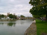
. Middleport is a port on the Erie Canal
.
The first store opened in the future village in 1822, before the canal reached the community.
The Erie Canal was opened along its entire length in 1825, and the community became an important location on the canal.
The village was formerly known as Tea-Pot Hollow before it was renamed Middleport.
The Village of Middleport was incorporated in 1872. The first election was held on March 22, 1859. The first meeting of the Board of Trustees was held on March 28, 1859.
The U.S. Post Office
is listed on the National Register of Historic Places.
According to the United States Census Bureau
, the village has a total area of 0.9 square miles (2.3 km²), all of it land.
The village is located where north-south New York State Route 271
(Main Street) crosses east-west highways New York State Route 31
(Telegraph Road) and New York State Route 31E
(State Street).
of 2000, there were 1,917 people, 756 households, and 508 families residing in the village. The population density
was 2,195.9 people per square mile (850.8/km²). There were 828 housing units at an average density of 948.5 per square mile (367.5/km²). The racial makeup of the village was 97.39% White, 0.83% African American, 0.26% Native American, 0.47% Asian, 0.26% from other races
, and 0.78% from two or more races. Hispanic or Latino of any race were 1.77% of the population.
There were 756 households out of which 35.4% had children under the age of 18 living with them, 52.5% were married couples
living together, 10.3% had a female householder with no husband present, and 32.7% were non-families. 27.6% of all households were made up of individuals and 13.9% had someone living alone who was 65 years of age or older. The average household size was 2.54 and the average family size was 3.11.
In the village the population was spread out with 28.7% under the age of 18, 6.4% from 18 to 24, 29.3% from 25 to 44, 20.7% from 45 to 64, and 14.9% who were 65 years of age or older. The median age was 36 years. For every 100 females there were 90.0 males. For every 100 females age 18 and over, there were 87.5 males.
The median income for a household in the village was $36,464, and the median income for a family was $44,712. Males had a median income of $35,135 versus $22,500 for females. The per capita income
for the village was $17,043. About 6.3% of families and 8.3% of the population were below the poverty line, including 7.1% of those under age 18 and 8.8% of those age 65 or over.
Niagara County, New York
Niagara County is a county located in the U.S. state of New York. As of the 2010 census, the population was 216,469. The county seat is Lockport. The county name is from the Iroquois word Onguiaahra; meaning the strait or thunder of waters. It is the location of Niagara Falls and Fort Niagara, and...
, New York, United States. The population was 1,917 at the 2000 census. The mail ZIP code is 14105. It is part of the Buffalo
Buffalo, New York
Buffalo is the second most populous city in the state of New York, after New York City. Located in Western New York on the eastern shores of Lake Erie and at the head of the Niagara River across from Fort Erie, Ontario, Buffalo is the seat of Erie County and the principal city of the...
–Niagara Falls
Niagara Falls, New York
Niagara Falls is a city in Niagara County, New York, United States. As of the 2010 census, the city had a total population of 50,193, down from the 55,593 recorded in the 2000 census. It is across the Niagara River from Niagara Falls, Ontario , both named after the famed Niagara Falls which they...
Metropolitan Statistical Area
Buffalo-Niagara Falls metropolitan area
The Buffalo-Niagara Falls Metropolitan Statistical Area is a metropolitan area, designated by the United States Census Bureau, encompassing two counties – Erie and Niagara – in Western New York, with a population, as of the 2010 census, of 1,135,509 inhabitants...
.
The Village of Middleport lies on the western edge of Niagara County, mostly inside the boundaries of the Town of Royalton
Royalton, New York
Royalton is a town in Niagara County, New York, United States. The population was 7,660 at the 2010 census.The Town of Royalton is in the southeast corner of the county and is east of the City of Niagara Falls.- History :...
, but a small part is within the Town of Hartland
Hartland, New York
Hartland is a town in Niagara County, New York, USA.The population was 4,117 at the 2010 census.The town is named after Hartland, Vermont, the homeplace of some early settlers.The Town of Hartland is on the eastern border of the county.- History :...
. Middleport is a port on the Erie Canal
Erie Canal
The Erie Canal is a waterway in New York that runs about from Albany, New York, on the Hudson River to Buffalo, New York, at Lake Erie, completing a navigable water route from the Atlantic Ocean to the Great Lakes. The canal contains 36 locks and encompasses a total elevation differential of...
.
History
Settlers began moving into the area around 1808.The first store opened in the future village in 1822, before the canal reached the community.
The Erie Canal was opened along its entire length in 1825, and the community became an important location on the canal.
The village was formerly known as Tea-Pot Hollow before it was renamed Middleport.
The Village of Middleport was incorporated in 1872. The first election was held on March 22, 1859. The first meeting of the Board of Trustees was held on March 28, 1859.
The U.S. Post Office
U.S. Post Office (Middleport, New York)
The U.S. Post Office in Middleport, New York, is located at Main and Church streets. It is a brick building erected in the late 1930s, serving the 14105 ZIP Code, which covers the village of Middleport and surrounding areas of the towns of Hartland and Royalton.It is one of only three in the state...
is listed on the National Register of Historic Places.
Geography
Middleport is located at 43°12′42"N 78°28′33"W (43.211756, -78.475734).According to the United States Census Bureau
United States Census Bureau
The United States Census Bureau is the government agency that is responsible for the United States Census. It also gathers other national demographic and economic data...
, the village has a total area of 0.9 square miles (2.3 km²), all of it land.
The village is located where north-south New York State Route 271
New York State Route 271
New York State Route 271 is a north–south state highway in eastern Niagara County, New York, in the United States. It primarily serves as Middleport's Main Street, connecting NY 31 in the south to NY 104 in the north. The southernmost portion of NY 271 is concurrent with...
(Main Street) crosses east-west highways New York State Route 31
New York State Route 31
New York State Route 31 is a state highway that extends for across western and central New York in the United States. The western terminus of the route is at an intersection with NY 104 in the city of Niagara Falls. Its eastern terminus is at a traffic circle with NY 26 in Vernon...
(Telegraph Road) and New York State Route 31E
New York State Route 31E
New York State Route 31E is a state highway located in Western New York in the United States. It serves as a northerly alternate route of NY 31 between the village of Middleport in eastern Niagara County and the nearby village of Medina in Orleans County...
(State Street).
Demographics
As of the censusCensus
A census is the procedure of systematically acquiring and recording information about the members of a given population. It is a regularly occurring and official count of a particular population. The term is used mostly in connection with national population and housing censuses; other common...
of 2000, there were 1,917 people, 756 households, and 508 families residing in the village. The population density
Population density
Population density is a measurement of population per unit area or unit volume. It is frequently applied to living organisms, and particularly to humans...
was 2,195.9 people per square mile (850.8/km²). There were 828 housing units at an average density of 948.5 per square mile (367.5/km²). The racial makeup of the village was 97.39% White, 0.83% African American, 0.26% Native American, 0.47% Asian, 0.26% from other races
Race (United States Census)
Race and ethnicity in the United States Census, as defined by the Federal Office of Management and Budget and the United States Census Bureau, are self-identification data items in which residents choose the race or races with which they most closely identify, and indicate whether or not they are...
, and 0.78% from two or more races. Hispanic or Latino of any race were 1.77% of the population.
There were 756 households out of which 35.4% had children under the age of 18 living with them, 52.5% were married couples
Marriage
Marriage is a social union or legal contract between people that creates kinship. It is an institution in which interpersonal relationships, usually intimate and sexual, are acknowledged in a variety of ways, depending on the culture or subculture in which it is found...
living together, 10.3% had a female householder with no husband present, and 32.7% were non-families. 27.6% of all households were made up of individuals and 13.9% had someone living alone who was 65 years of age or older. The average household size was 2.54 and the average family size was 3.11.
In the village the population was spread out with 28.7% under the age of 18, 6.4% from 18 to 24, 29.3% from 25 to 44, 20.7% from 45 to 64, and 14.9% who were 65 years of age or older. The median age was 36 years. For every 100 females there were 90.0 males. For every 100 females age 18 and over, there were 87.5 males.
The median income for a household in the village was $36,464, and the median income for a family was $44,712. Males had a median income of $35,135 versus $22,500 for females. The per capita income
Per capita income
Per capita income or income per person is a measure of mean income within an economic aggregate, such as a country or city. It is calculated by taking a measure of all sources of income in the aggregate and dividing it by the total population...
for the village was $17,043. About 6.3% of families and 8.3% of the population were below the poverty line, including 7.1% of those under age 18 and 8.8% of those age 65 or over.