
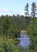
Metolius Springs
Encyclopedia
Metolius Springs are located just north of Black Butte
near the small unincorporated town of Camp Sherman
in central Oregon
, United States
. The springs are the source of the Metolius River
, which flows 29 miles (46.7 km) through the Deschutes National Forest
emptying into Lake Billy Chinook. The flow from Metolius Springs is sufficient to create a full-flowing river, making the Metolius River one of the largest spring-fed rivers in the United States
.
 The source of the springs is unknown, but there is evidence that it comes from a large drainage basin near Black Butte Ranch, several miles south of Black Butte. The elevation of the Black Butte Ranch drainage basin is 300 feet (91.4 m) above that of the springs which would allow a natural flow of water under Black Butte to the Metolius headwaters.
The springs were probably created about one and a half million years ago when Black Butte erupted
blocking a north-flowing river. With the newly formed butte blocking the natural channel, water backed up south of the mountain creating a swampy meadow area. Over time, the water seeps through porous rocks under the butte and now emerges on the north side of Black Butte at Metolius Springs.
There are two groups of springs about 200 feet (61 m) apart that create the headwaters of the Metolius River. Springwater gushes from its underground source at a rate of 50,000 gallons per minute. This makes the Metolius one of the largest spring-fed rivers in the country. The water temperature at the springs is 48° Fahrenheit
.
.
Today, the Deschutes National Forest maintains a day-use viewing area overlooking Metolius Springs. The site is normally open from April until November. It includes a paved walkway from the parking area to the Metolius Springs viewing point with interpretative signs along the way. There are also three picnic table
s and a vault-type toilet
facility. However, there is no water and camping
is not allowed at the site.
Black Butte (Oregon)
Black Butte is a cinder cone butte located in Deschutes National Forest, northwest of the town of Sisters, Oregon. An extinct volcano, it is composed of basaltic andesite. The cone rises over the surrounding plateau. Black Butte is a striking feature just north of US Highway 20, which descends...
near the small unincorporated town of Camp Sherman
Camp Sherman, Oregon
Camp Sherman is an unincorporated community in Jefferson County, Oregon, United States. It is located on the Metolius River. The population consists of a few hundred year-round residents, swelling to several thousand during the summer. The community includes an elementary school, Black Butte...
in central Oregon
Oregon
Oregon is a state in the Pacific Northwest region of the United States. It is located on the Pacific coast, with Washington to the north, California to the south, Nevada on the southeast and Idaho to the east. The Columbia and Snake rivers delineate much of Oregon's northern and eastern...
, United States
United States
The United States of America is a federal constitutional republic comprising fifty states and a federal district...
. The springs are the source of the Metolius River
Metolius River
The Metolius River is a tributary of the Deschutes River in Central Oregon, United States, near the city of Sisters. The river flows north from springs near Black Butte, then turns sharply east, descending through a series of gorges before ending in the western end of the lake...
, which flows 29 miles (46.7 km) through the Deschutes National Forest
Deschutes National Forest
The Deschutes National Forest is a United States National Forest located in parts of Deschutes, Klamath, Lake, and Jefferson counties in central Oregon. It comprises 1.8 million acres along the east side of the Cascade mountains. In 1908, the Deschutes National Forest was established from parts...
emptying into Lake Billy Chinook. The flow from Metolius Springs is sufficient to create a full-flowing river, making the Metolius River one of the largest spring-fed rivers in the United States
United States
The United States of America is a federal constitutional republic comprising fifty states and a federal district...
.
Source
The springs were probably created about one and a half million years ago when Black Butte erupted
Stratovolcano
A stratovolcano, also known as a composite volcano, is a tall, conical volcano built up by many layers of hardened lava, tephra, pumice, and volcanic ash. Unlike shield volcanoes, stratovolcanoes are characterized by a steep profile and periodic, explosive eruptions...
blocking a north-flowing river. With the newly formed butte blocking the natural channel, water backed up south of the mountain creating a swampy meadow area. Over time, the water seeps through porous rocks under the butte and now emerges on the north side of Black Butte at Metolius Springs.
There are two groups of springs about 200 feet (61 m) apart that create the headwaters of the Metolius River. Springwater gushes from its underground source at a rate of 50,000 gallons per minute. This makes the Metolius one of the largest spring-fed rivers in the country. The water temperature at the springs is 48° Fahrenheit
Fahrenheit
Fahrenheit is the temperature scale proposed in 1724 by, and named after, the German physicist Daniel Gabriel Fahrenheit . Within this scale, the freezing of water into ice is defined at 32 degrees, while the boiling point of water is defined to be 212 degrees...
.
Viewing area
The Metolius Springs and 160 acre (0.6474976 km²) around it were originally owned by Sam Johnson, a wealthy lumber mill owner. Johnson preserved the springs in their natural state, and allowed public access to a scenic headwaters viewing area located on his land. In 1965, Johnson gave the Metolius Springs viewing area to the United States Forest ServiceUnited States Forest Service
The United States Forest Service is an agency of the United States Department of Agriculture that administers the nation's 155 national forests and 20 national grasslands, which encompass...
.
Today, the Deschutes National Forest maintains a day-use viewing area overlooking Metolius Springs. The site is normally open from April until November. It includes a paved walkway from the parking area to the Metolius Springs viewing point with interpretative signs along the way. There are also three picnic table
Picnic table
A picnic table is a modified table with attached benches, designed for eating a meal outdoors .-Uses:...
s and a vault-type toilet
Outhouse
An outhouse is a small structure separate from a main building which often contained a simple toilet and may possibly also be used for housing animals and storage.- Terminology :...
facility. However, there is no water and camping
Camping
Camping is an outdoor recreational activity. The participants leave urban areas, their home region, or civilization and enjoy nature while spending one or several nights outdoors, usually at a campsite. Camping may involve the use of a tent, caravan, motorhome, cabin, a primitive structure, or no...
is not allowed at the site.