
Mascoutah, Illinois
Encyclopedia
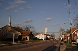
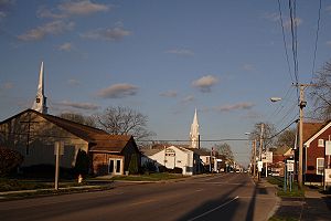
Mascoutah is a small town in St. Clair County, Illinois
, United States
. The population was 7,483 at the 2010 census.
According to the United States Census Bureau
, the city has a total area of 8.7 square miles (22.5 km²), of which, 8.6 square miles (22.3 km²) of it is land and 0.1 square mile (0.258998811 km²) of it (0.69%) is water.
point in 1970. As of the census
of 2000, there were 5,659 people, 2,162 households, and 1,571 families residing in the city. The population density
was 655.1 people per square mile (252.9/km²). There were 2,309 housing units at an average density of 267.3 per square mile (103.2/km²). The racial makeup of the city was 91.73% White, 4.19% African American, 0.35% Native American, 0.97% Asian, 0.05% Pacific Islander, 0.85% from other races
, and 1.86% from two or more races. Hispanic or Latino of any race were 1.75% of the population.
There were 2,162 households out of which 35.8% had children under the age of 18 living with them, 57.5% were married couples
living together, 11.2% had a female householder with no husband present, and 27.3% were non-families. 23.7% of all households were made up of individuals and 10.5% had someone living alone who was 65 years of age or older. The average household size was 2.57 and the average family size was 3.05.
In the city the population was spread out with 26.4% under the age of 18, 8.5% from 18 to 24, 29.4% from 25 to 44, 21.5% from 45 to 64, and 14.2% who were 65 years of age or older. The median age was 38 years. For every 100 females there were 92.4 males. For every 100 females age 18 and over, there were 90.1 males.
The median income for a household in the city was $46,451, and the median income for a family was $55,018. Males had a median income of $37,182 versus $23,156 for females. The per capita income
for the city was $21,569. About 6.3% of families and 7.8% of the population were below the poverty line, including 11.8% of those under age 18 and 7.9% of those age 65 or over.
Mascoutah is located just off Interstate 64 and is in close proximity to St. Louis, Missouri. Mascoutah accessible to St. Louis and Lambert Airport by Metrolink with stations a few miles out of town. Mascoutah is home to Mid America Airport. Nearby Scott AFB is a major employer and base residents attend school in Mascoutah.
Holy Childhood School is the private catholic school in Mascoutah. It offers preschool through eighth grade.
St. Clair County, Illinois
St. Clair County is a county located in the U.S. state of Illinois. In 1970, the U.S. Census Bureau placed the mean center of U.S. population in St. Clair County. According to the 2010 census, it has a population of 270,056, which is an increase of 5.5% from 256,082 in 2000. Its county seat is...
, United States
United States
The United States of America is a federal constitutional republic comprising fifty states and a federal district...
. The population was 7,483 at the 2010 census.
Geography
Mascoutah is located at 38°29′50"N 89°48′4"W (38.497312, -89.801248).According to the United States Census Bureau
United States Census Bureau
The United States Census Bureau is the government agency that is responsible for the United States Census. It also gathers other national demographic and economic data...
, the city has a total area of 8.7 square miles (22.5 km²), of which, 8.6 square miles (22.3 km²) of it is land and 0.1 square mile (0.258998811 km²) of it (0.69%) is water.
Demographics
Mascoutah was the United States center of populationCenter of population
In demographics, the center of population of a region is a geographical point that describes a centerpoint of the region's population...
point in 1970. As of the census
Census
A census is the procedure of systematically acquiring and recording information about the members of a given population. It is a regularly occurring and official count of a particular population. The term is used mostly in connection with national population and housing censuses; other common...
of 2000, there were 5,659 people, 2,162 households, and 1,571 families residing in the city. The population density
Population density
Population density is a measurement of population per unit area or unit volume. It is frequently applied to living organisms, and particularly to humans...
was 655.1 people per square mile (252.9/km²). There were 2,309 housing units at an average density of 267.3 per square mile (103.2/km²). The racial makeup of the city was 91.73% White, 4.19% African American, 0.35% Native American, 0.97% Asian, 0.05% Pacific Islander, 0.85% from other races
Race (United States Census)
Race and ethnicity in the United States Census, as defined by the Federal Office of Management and Budget and the United States Census Bureau, are self-identification data items in which residents choose the race or races with which they most closely identify, and indicate whether or not they are...
, and 1.86% from two or more races. Hispanic or Latino of any race were 1.75% of the population.
There were 2,162 households out of which 35.8% had children under the age of 18 living with them, 57.5% were married couples
Marriage
Marriage is a social union or legal contract between people that creates kinship. It is an institution in which interpersonal relationships, usually intimate and sexual, are acknowledged in a variety of ways, depending on the culture or subculture in which it is found...
living together, 11.2% had a female householder with no husband present, and 27.3% were non-families. 23.7% of all households were made up of individuals and 10.5% had someone living alone who was 65 years of age or older. The average household size was 2.57 and the average family size was 3.05.
In the city the population was spread out with 26.4% under the age of 18, 8.5% from 18 to 24, 29.4% from 25 to 44, 21.5% from 45 to 64, and 14.2% who were 65 years of age or older. The median age was 38 years. For every 100 females there were 92.4 males. For every 100 females age 18 and over, there were 90.1 males.
The median income for a household in the city was $46,451, and the median income for a family was $55,018. Males had a median income of $37,182 versus $23,156 for females. The per capita income
Per capita income
Per capita income or income per person is a measure of mean income within an economic aggregate, such as a country or city. It is calculated by taking a measure of all sources of income in the aggregate and dividing it by the total population...
for the city was $21,569. About 6.3% of families and 7.8% of the population were below the poverty line, including 11.8% of those under age 18 and 7.9% of those age 65 or over.
Location
Mascoutah is located just off Interstate 64 and is in close proximity to St. Louis, Missouri. Mascoutah accessible to St. Louis and Lambert Airport by Metrolink with stations a few miles out of town. Mascoutah is home to Mid America Airport. Nearby Scott AFB is a major employer and base residents attend school in Mascoutah.
Parks
There are three parks in town that offer a wide array of activities. Scheve Park has two swimming pools, 6 baseball diamonds (2 with lights), two lighted tennis courts, a lighted sand volleyball court, lighted horseshoe pits, two soccer fields, ten pavilions varying in size, and several playground areas. Scheve Park also has a restored train caboose that visitors can tour. Maple Park is equipped with outdoor basketball facilities, a ball playing area, playground equipment, and a family sized pavilion. Prairie Park has two fishing lakes, a fountain, and a pavilion.Education
Mascoutah Community Unit School District#19 serves the city. There are four schools in the district: Mascoutah Community High School, Mascoutah Middle School, Mascoutah Elementary School, and Scott Air Force Base Elementary School.Holy Childhood School is the private catholic school in Mascoutah. It offers preschool through eighth grade.