

Center of population
Encyclopedia
Demographics
Demographics are the most recent statistical characteristics of a population. These types of data are used widely in sociology , public policy, and marketing. Commonly examined demographics include gender, race, age, disabilities, mobility, home ownership, employment status, and even location...
, the center of population (or population center) of a region is a geographical point that describes a centerpoint of the region's population. There are several different ways of defining such a "center point", leading to different geographical locations; these are often confused.
Definitions
Three commonly used (but different) center points are:- the meanMeanIn statistics, mean has two related meanings:* the arithmetic mean .* the expected value of a random variable, which is also called the population mean....
center, also known as the centroidCentroidIn geometry, the centroid, geometric center, or barycenter of a plane figure or two-dimensional shape X is the intersection of all straight lines that divide X into two parts of equal moment about the line. Informally, it is the "average" of all points of X...
or center of gravityCenter of gravityIn physics, a center of gravity of a material body is a point that may be used for a summary description of gravitational interactions. In a uniform gravitational field, the center of mass serves as the center of gravity...
; - the medianMedianIn probability theory and statistics, a median is described as the numerical value separating the higher half of a sample, a population, or a probability distribution, from the lower half. The median of a finite list of numbers can be found by arranging all the observations from lowest value to...
center, which is the intersection of the median longitudeLongitudeLongitude is a geographic coordinate that specifies the east-west position of a point on the Earth's surface. It is an angular measurement, usually expressed in degrees, minutes and seconds, and denoted by the Greek letter lambda ....
and median latitudeLatitudeIn geography, the latitude of a location on the Earth is the angular distance of that location south or north of the Equator. The latitude is an angle, and is usually measured in degrees . The equator has a latitude of 0°, the North pole has a latitude of 90° north , and the South pole has a...
; - the geometric medianGeometric medianThe geometric median of a discrete set of sample points in a Euclidean space is the point minimizing the sum of distances to the sample points. This generalizes the median, which has the property of minimizing the sum of distances for one-dimensional data, and provides a central tendency in higher...
, also known as Weber point, Fermat–Weber point, or point of minimum aggregate travel.
A further complication is caused by the curved shape of the Earth. Different center points are obtained depending on whether the center is computed in three-dimensional space, or restricted to the curved surface, or computed using a flat map projection
Map projection
A map projection is any method of representing the surface of a sphere or other three-dimensional body on a plane. Map projections are necessary for creating maps. All map projections distort the surface in some fashion...
.
Mean center
The mean center, or centroid, is the point on which a rigid, weightless map would balance perfectly, if the population members are represented as points of equal mass.Mathematically, the centroid is the point to which the population has the smallest possible sum of squared distances. It is easily found by taking the arithmetic mean
Mean
In statistics, mean has two related meanings:* the arithmetic mean .* the expected value of a random variable, which is also called the population mean....
of each coordinate. If defined in the three-dimensional space, the centroid of points on the Earth's surface is actually inside the Earth. This point could then be projected back to the surface. Alternatively, one could define the centroid directly on a flat map projection; this is, for example, the definition that the US Census Bureau uses.
Contrary to a common misconception, the centroid does not minimize the average distance to the population. That property belongs to the geometric median.
Median center
The median center is the intersection of two perpendicular lines, each of which divides the population into two equal halves. Typically these two lines are chosen to be a parallelCircle of latitude
A circle of latitude, on the Earth, is an imaginary east-west circle connecting all locations that share a given latitude...
(a line of latitude
Latitude
In geography, the latitude of a location on the Earth is the angular distance of that location south or north of the Equator. The latitude is an angle, and is usually measured in degrees . The equator has a latitude of 0°, the North pole has a latitude of 90° north , and the South pole has a...
) and a meridian
Meridian (geography)
A meridian is an imaginary line on the Earth's surface from the North Pole to the South Pole that connects all locations along it with a given longitude. The position of a point along the meridian is given by its latitude. Each meridian is perpendicular to all circles of latitude...
(a line of longitude
Longitude
Longitude is a geographic coordinate that specifies the east-west position of a point on the Earth's surface. It is an angular measurement, usually expressed in degrees, minutes and seconds, and denoted by the Greek letter lambda ....
). In that case, this center is easily found by taking separately the median
Median
In probability theory and statistics, a median is described as the numerical value separating the higher half of a sample, a population, or a probability distribution, from the lower half. The median of a finite list of numbers can be found by arranging all the observations from lowest value to...
s of the population's latitude and longitude coordinates.
Geometric median
The geometric median is the point to which the population has the smallest possible sum of distances (or equivalently, the smallest average distance). Because of this property, it is also known as the point of minimum aggregate travel. Unfortunately, there is no direct closed-form expressionClosed-form expression
In mathematics, an expression is said to be a closed-form expression if it can be expressed analytically in terms of a bounded number of certain "well-known" functions...
for the geometric median; it is typically computed using iterative method
Iterative method
In computational mathematics, an iterative method is a mathematical procedure that generates a sequence of improving approximate solutions for a class of problems. A specific implementation of an iterative method, including the termination criteria, is an algorithm of the iterative method...
s.
Determination
In practical computation, decisions are also made on the granularity (coarseness) of the population data, depending on population density patterns or other factors. For instance, the center of population of all the cities in a country may be different from the center of population of all the states (or provinces, or other subdivisions) in the same country. Different methods may yield different results.Practical uses for finding the center of population include locating possible sites for forward capitals, such as Brasilia
Brasília
Brasília is the capital city of Brazil. The name is commonly spelled Brasilia in English. The city and its District are located in the Central-West region of the country, along a plateau known as Planalto Central. It has a population of about 2,557,000 as of the 2008 IBGE estimate, making it the...
, Astana
Astana
Astana , formerly known as Akmola , Tselinograd and Akmolinsk , is the capital and second largest city of Kazakhstan, with an officially estimated population of 708,794 as of 1 August 2010...
or Austin
Austin, Texas
Austin is the capital city of the U.S. state of :Texas and the seat of Travis County. Located in Central Texas on the eastern edge of the American Southwest, it is the fourth-largest city in Texas and the 14th most populous city in the United States. It was the third-fastest-growing large city in...
. Practical selection of a new site for a capital is a complex problem that depends also on population density patterns and transportation networks.
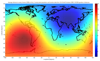
World
It is important to use a method that does not depend on a two-dimensional projection when dealing with the entire world. As described in INED (Institut national d'études démographiques), the solution methodology deals only with the globe. As a result, the answer is independent of which map projectionMap projection
A map projection is any method of representing the surface of a sphere or other three-dimensional body on a plane. Map projections are necessary for creating maps. All map projections distort the surface in some fashion...
is used or where it is centered. As described above, the exact location of the center of population will depend on both the granularity of the population data used, and the distance metric. With geodesic
Geodesic
In mathematics, a geodesic is a generalization of the notion of a "straight line" to "curved spaces". In the presence of a Riemannian metric, geodesics are defined to be the shortest path between points in the space...
distances as the metric, and a granularity of 1000 kilometres (621.4 mi), meaning that two population centers within 1000 km of each other are treated as part of a larger common population center of intermediate location, the world's center of population is found to lie "at the crossroads between China
China
Chinese civilization may refer to:* China for more general discussion of the country.* Chinese culture* Greater China, the transnational community of ethnic Chinese.* History of China* Sinosphere, the area historically affected by Chinese culture...
, India
India
India , officially the Republic of India , is a country in South Asia. It is the seventh-largest country by geographical area, the second-most populous country with over 1.2 billion people, and the most populous democracy in the world...
, Pakistan
Pakistan
Pakistan , officially the Islamic Republic of Pakistan is a sovereign state in South Asia. It has a coastline along the Arabian Sea and the Gulf of Oman in the south and is bordered by Afghanistan and Iran in the west, India in the east and China in the far northeast. In the north, Tajikistan...
and Tajikistan
Tajikistan
Tajikistan , officially the Republic of Tajikistan , is a mountainous landlocked country in Central Asia. Afghanistan borders it to the south, Uzbekistan to the west, Kyrgyzstan to the north, and China to the east....
", essentially located in Afghanistan
Afghanistan
Afghanistan , officially the Islamic Republic of Afghanistan, is a landlocked country located in the centre of Asia, forming South Asia, Central Asia and the Middle East. With a population of about 29 million, it has an area of , making it the 42nd most populous and 41st largest nation in the world...
, with an average distance of 5200 kilometres (3,231.1 mi) to all humans. The data used in the reference support this result to a precision
Accuracy and precision
In the fields of science, engineering, industry and statistics, the accuracy of a measurement system is the degree of closeness of measurements of a quantity to that quantity's actual value. The precision of a measurement system, also called reproducibility or repeatability, is the degree to which...
of only a few hundred kilometers, hence the exact location is not known.
Australia
AustraliaAustralia
Australia , officially the Commonwealth of Australia, is a country in the Southern Hemisphere comprising the mainland of the Australian continent, the island of Tasmania, and numerous smaller islands in the Indian and Pacific Oceans. It is the world's sixth-largest country by total area...
has not seen its population centroid move drastically since the creation of the country. In 1911, the centroid was in central New South Wales
New South Wales
New South Wales is a state of :Australia, located in the east of the country. It is bordered by Queensland, Victoria and South Australia to the north, south and west respectively. To the east, the state is bordered by the Tasman Sea, which forms part of the Pacific Ocean. New South Wales...
; in 1996, it was only slightly farther northwest.
Canada
In CanadaCanada
Canada is a North American country consisting of ten provinces and three territories. Located in the northern part of the continent, it extends from the Atlantic Ocean in the east to the Pacific Ocean in the west, and northward into the Arctic Ocean...
, a 1986 study placed the point of minimum aggregate travel just north of Toronto
Toronto
Toronto is the provincial capital of Ontario and the largest city in Canada. It is located in Southern Ontario on the northwestern shore of Lake Ontario. A relatively modern city, Toronto's history dates back to the late-18th century, when its land was first purchased by the British monarchy from...
in the city of Richmond Hill
Richmond Hill, Ontario
Richmond Hill is a town located in Southern Ontario, Canada in the central portion of York Region, Ontario. It is part of the Greater Toronto Area, being located about halfway between Toronto and Lake Simcoe...
, and moving westward at a rate of approximately 2 meters per day.
Finland
In FinlandFinland
Finland , officially the Republic of Finland, is a Nordic country situated in the Fennoscandian region of Northern Europe. It is bordered by Sweden in the west, Norway in the north and Russia in the east, while Estonia lies to its south across the Gulf of Finland.Around 5.4 million people reside...
, the point of minimum aggregate travel is located in the municipality of Hauho
Hauho
Hauho is a former municipality of Finland. It was situated in the province of Southern Finland and is today a part of the region of Tavastia Proper ....
. It is moving slightly to the west and south every year because people are moving out of the periphery areas of northern and eastern Finland.
Germany
In Germany, the centroid of the population is located in SpangenbergSpangenberg
- Geography :Spangenberg lies in the Schwalm-Eder district some 35 km southeast of Kassel, west of the Stölzinger Gebirge, a low mountain range. Spangenberg is the demographical centrepoint of Germany.- History :...
, Hesse
Hesse
Hesse or Hessia is both a cultural region of Germany and the name of an individual German state.* The cultural region of Hesse includes both the State of Hesse and the area known as Rhenish Hesse in the neighbouring Rhineland-Palatinate state...
close to Kassel
Kassel
Kassel is a town located on the Fulda River in northern Hesse, Germany. It is the administrative seat of the Kassel Regierungsbezirk and the Kreis of the same name and has approximately 195,000 inhabitants.- History :...
.
Great Britain
A centre of population in Great BritainGreat Britain
Great Britain or Britain is an island situated to the northwest of Continental Europe. It is the ninth largest island in the world, and the largest European island, as well as the largest of the British Isles...
did not move much in the 20th century. In 1901, it was in Rodsley
Rodsley
Rodsley is a small village about four miles south of Ashbourne in Derbyshire.-History:Nearby Hollington and Rodsley are included as manors in the 1086 Domesday Survey as belonging to Henry de Ferrers, who was given a large number of manors in Derbyshire. His descendants became the Earls of Derby...
, Derbyshire
Derbyshire
Derbyshire is a county in the East Midlands of England. A substantial portion of the Peak District National Park lies within Derbyshire. The northern part of Derbyshire overlaps with the Pennines, a famous chain of hills and mountains. The county contains within its boundary of approx...
and in 1911 in Longford
Longford, Derbyshire
Longford is a village in Derbyshire, England. It is six miles from Ashbourne and eleven miles west of Derby.-History:In 1872 the parish of Longford was described as having just over 1150 people and 220 dwellings. This parish took in the settlements of Alkmonton, Rodsley, Hollington and the...
. In 1971 it was at Newhall
Newhall, Derbyshire
Newhall is a town located in South Derbyshire, England. The village of Stanton is nearby and in the same parish.-Newhall village:The village lies between the A444 to its south and the A511 to its north. To its east is the market town of Ashby-de-la-Zouch, very close to the M42 linking Nottingham ...
, South Derbyshire
South Derbyshire
South Derbyshire is a local government district in Derbyshire, England. It contains a third of the National Forest, and the council offices are in Swadlincote....
and in 2000, it was in Appleby Parva
Appleby Parva
Appleby Parva, or Little Appleby , part of the parish of Appleby Magna in Leicestershire, is a hamlet about a mile south of Appleby church at the crossroads of the highways from Ashby de la Zouch to Tamworth and from Atherstone to Burton upon Trent.The village was also calculated to be the centre...
, Leicestershire
Leicestershire
Leicestershire is a landlocked county in the English Midlands. It takes its name from the heavily populated City of Leicester, traditionally its administrative centre, although the City of Leicester unitary authority is today administered separately from the rest of Leicestershire...
.
Japan
The centroid of population of JapanJapan
Japan is an island nation in East Asia. Located in the Pacific Ocean, it lies to the east of the Sea of Japan, China, North Korea, South Korea and Russia, stretching from the Sea of Okhotsk in the north to the East China Sea and Taiwan in the south...
is in Gifu Prefecture
Gifu Prefecture
is a prefecture located in the Chūbu region of central Japan. Its capital is the city of Gifu.Located in the center of Japan, it has long played an important part as the crossroads of Japan, connecting the east to the west through such routes as the Nakasendō...
, almost directly north of Nagoya city, and has been moving east south east for the past few decades. More recently, the only large regions in Japan with significant population growth have been in Greater Nagoya and Greater Tokyo.
Sweden
The demographical center of SwedenDemographical center of Sweden
The demographic center of a country is the point to which the cumulative distance the registered population have to travel is the smallest, were they all to meet at a single location. As the population distribution of a country changes, the demographic center will move...
(using the median center definition) is Hjortkvarn
Hjortkvarn
Hjortkvarn is a locality situated in Hallsberg Municipality, Örebro County, Sweden with 251 inhabitants in 2005....
in Hallsberg Municipality
Hallsberg Municipality
Hallsberg Municipality is a municipality in Örebro County in central Sweden. Its seat is located in the town of Hallsberg....
, Örebro
Örebro
-Sites of interest:Örebro's old town Wadköping is located on the banks of Svartån . It contains many 18th and 19th century wooden houses, along with museums and exhibitions....
county. Between the 1989 and 2007 census the point moved a few kilometres to the south, due to a decreasing population in northern Sweden and immigration to the south.
United States
The mean center of United States population (using the centroid definition) has been calculated for each U.S. CensusUnited States Census
The United States Census is a decennial census mandated by the United States Constitution. The population is enumerated every 10 years and the results are used to allocate Congressional seats , electoral votes, and government program funding. The United States Census Bureau The United States Census...
since 1790. Currently this point is located in Texas County, Missouri
Texas County, Missouri
Texas County is a county located in South Central Missouri in the United States. As of the 2010 census, the county's population was 26,008. It's county seat is Houston. The county was organized in 1843 as Ashley County, changing its name in 1845 to Texas, after the Republic of Texas. The 2010 U.S...
, in the central part of the state. However, when Washington, D.C.
Washington, D.C.
Washington, D.C., formally the District of Columbia and commonly referred to as Washington, "the District", or simply D.C., is the capital of the United States. On July 16, 1790, the United States Congress approved the creation of a permanent national capital as permitted by the U.S. Constitution....
was chosen as the federal capital of the United States in 1790, the center of the U.S. population was in Kent County, Maryland
Kent County, Maryland
Kent County is a county located in the U.S. state of Maryland, on its Eastern Shore. It was named for the county of Kent in England. Its county seat is Chestertown. In 2010, the county population was 20,197...
, a mere 47 miles (75.6 km) east-northeast of the new capital. Over the last two centuries, the mean center of United States population has progressed westward and, since 1930, southwesterly, reflecting population drift. The mean center of population in the United States is currently near Plato, Missouri
Plato, Missouri
Plato is an incorporated village in northwestern Texas County, Missouri, United States. It is located about twenty miles northwest of Houston, Missouri and ten miles south of Fort Leonard Wood on Route 32. Plato had an estimated population of 1,430 in 2000....
. The median center of United States population
Median center of United States population
The median center of U.S. population is determined by the United States Census Bureau from the results of each census. The Bureau defines it to be:- See also :* Mean center of United States population* Center of population...
is currently located in Pike County, Indiana
Pike County, Indiana
As of the census of 2000, there were 12,837 people, 5,119 households, and 3,680 families residing in the county. The population density was 38 people per square mile . There were 5,611 housing units at an average density of 17 per square mile...
.
Sources
- Bellone F. and Cunningham R. (1993). "All Roads Lead to... Laxton, Digby and Longford." Statistics Canada 1991 Census Short Articles Series.
External links
- Australian parliamentary research paper with map of population centroids.
- Population centers of each U.S. state, 2000 (United States Census BureauUnited States Census BureauThe United States Census Bureau is the government agency that is responsible for the United States Census. It also gathers other national demographic and economic data...
)