
Maryland Route 610
Encyclopedia
Maryland Route 610 is a state highway
in the U.S. state
of Maryland
. Known for most of its length as Whaleyville Road, the state highway runs 6.53 miles (10.5 km) from the county-maintained portion of Dale Road near Whaleyville
north to U.S. Route 113
(US 113) near Bishop
. The first segment of MD 610 was constructed near Whaleyville in the mid 1930s. The highway to Bishop was brought into the state highway system in the 1940s. MD 610, which did not originally reach US 50
, was extended south to that highway, now MD 346
, in 1955. The state highway reached its current southern terminus after the US 50 divided highway was constructed in the mid 1960s.
.
by 1934. By 1946, state maintenance was extended east to Campbelltown Road near Bishop. The segment between Campbelltown Road and US 113 was brought under state maintenance in 1950. In 1955, MD 610 was extended south along a new alignment from Sheppards Crossing Road to present day MD 346. The state highway was extended south again in 1966 to both connect with the new US 50 divided highway and to access properties on Dale Road, whose original alignment had been interrupted by the relocation of US 50.
.
{| class=wikitable
!Location
!Mile
!Destinations
!Notes
|-
|rowspan=3|Whaleyville
|0.00
|Dale Road south
|Southern terminus
|-
|0.20
|
|
|-
|0.73
|
|Old alignment of US 50
|-
|rowspan=2|Bishop
|rowspan=2|6.53
|, Selbyville, DE
|rowspan=2|Northern terminus
|-
|Hammond Road – Bishopville
State highway
State highway, state road or state route can refer to one of three related concepts, two of them related to a state or provincial government in a country that is divided into states or provinces :#A...
in the U.S. state
U.S. state
A U.S. state is any one of the 50 federated states of the United States of America that share sovereignty with the federal government. Because of this shared sovereignty, an American is a citizen both of the federal entity and of his or her state of domicile. Four states use the official title of...
of Maryland
Maryland
Maryland is a U.S. state located in the Mid Atlantic region of the United States, bordering Virginia, West Virginia, and the District of Columbia to its south and west; Pennsylvania to its north; and Delaware to its east...
. Known for most of its length as Whaleyville Road, the state highway runs 6.53 miles (10.5 km) from the county-maintained portion of Dale Road near Whaleyville
Whaleyville, Maryland
Whaleyville is a census-designated place in Worcester County, Maryland, United States. The population was 124 at the 2000 census.-Geography:Whaleyville is located at ....
north to U.S. Route 113
U.S. Route 113
U.S. Route 113 is a spur of US 13 in the U.S. states of Maryland and Delaware. The U.S. Highway runs from US 13 in Pocomoke City, Maryland north to Delaware Route 1 in Milford, Delaware...
(US 113) near Bishop
Bishop, Maryland
Bishop is an unincorporated community in Worcester County, Maryland, United States. Bishop is located at the intersection of U.S. Route 113 and Maryland Route 367 just south of the Delaware state line.-References:...
. The first segment of MD 610 was constructed near Whaleyville in the mid 1930s. The highway to Bishop was brought into the state highway system in the 1940s. MD 610, which did not originally reach US 50
U.S. Route 50 in Maryland
U.S. Route 50 is a major east–west route of the U.S. Highway system, stretching just over from Ocean City, Maryland on the Atlantic Ocean to West Sacramento, California. In the U.S. state of Maryland, US 50 exists in two sections. The longer of these serves as a major route connecting...
, was extended south to that highway, now MD 346
Maryland Route 346
Maryland Route 346 is a state highway in the U.S. state of Maryland. The state highway runs from U.S. Route 50 Business in Salisbury east to US 50 in Berlin...
, in 1955. The state highway reached its current southern terminus after the US 50 divided highway was constructed in the mid 1960s.
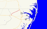
Route description
MD 610 begins at a point on Dale Road 0.2 mi (0.321868 km) south of US 50 (Ocean Gateway) near Whaleyville. The state highway heads north from the intersection with US 50 as two-lane Whaleyville Road. After crossing MD 346 (Old Ocean City Boulevard), MD 610 bypasses the center of Whaleyville on the west and intersects Sheppards Crossing Road. The state highway curves to the northeast and crosses Shavox Church Road and Peerless Road as well as Birch Branch on the way to its eastern terminus at US 113 (Worcester Highway) north of Bishop. Hammond Road, which for a short stretch is unsigned MD 575L, continues east on the other side of the intersection toward BishopvilleBishopville, Maryland
Bishopville is a small unincorporated community 10 miles north of Berlin in Worcester County, Maryland, located at . The community is just south of the Delaware state line....
.
History
The first segment of MD 610 was constructed from Sheppards Crossing Road to Donaway Road north of Whaleyville in 1935. It was connected to US 213 (later US 50 and now MD 346) by Sheppards Crossing Road, which was improved by the Maryland State Roads CommissionMaryland State Highway Administration
The Maryland State Highway Administration is the state agency responsible for maintaining Maryland numbered highways outside of Baltimore City...
by 1934. By 1946, state maintenance was extended east to Campbelltown Road near Bishop. The segment between Campbelltown Road and US 113 was brought under state maintenance in 1950. In 1955, MD 610 was extended south along a new alignment from Sheppards Crossing Road to present day MD 346. The state highway was extended south again in 1966 to both connect with the new US 50 divided highway and to access properties on Dale Road, whose original alignment had been interrupted by the relocation of US 50.
Junction list
The entire route is in Worcester CountyWorcester County, Maryland
-2010:Whereas according to the 2010 U.S. Census Bureau:*82.0% White*13.6% Black*0.3% Native American*1.1% Asian*0.0% Native Hawaiian or Pacific Islander*1.7% Two or more races*1.3% Other races*3.2% Hispanic or Latino -2000:...
.
{| class=wikitable
!Location
!Mile
!Destinations
!Notes
|-
|rowspan=3|Whaleyville
Whaleyville, Maryland
Whaleyville is a census-designated place in Worcester County, Maryland, United States. The population was 124 at the 2000 census.-Geography:Whaleyville is located at ....
|0.00
|Dale Road south
|Southern terminus
|-
|0.20
|
|
|-
|0.73
|
|Old alignment of US 50
|-
|rowspan=2|Bishop
Bishop, Maryland
Bishop is an unincorporated community in Worcester County, Maryland, United States. Bishop is located at the intersection of U.S. Route 113 and Maryland Route 367 just south of the Delaware state line.-References:...
|rowspan=2|6.53
|, Selbyville, DE
Selbyville, Delaware
As of the census of 2000, there were 1,645 people, 615 households, and 439 families residing in the town. The population density was 1,176.9 people per square mile . There were 664 housing units at an average density of 475.1 per square mile...
|rowspan=2|Northern terminus
|-
|Hammond Road – Bishopville
Bishopville, Maryland
Bishopville is a small unincorporated community 10 miles north of Berlin in Worcester County, Maryland, located at . The community is just south of the Delaware state line....