
Maryland Route 337
Encyclopedia
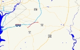
Maryland Route 337, Allentown Road, is a short road in Prince George's
county, Maryland
. It begins at its intersection with Maryland Route 5
and ends at MD Route 4
, going east through the communities of Camp Springs and Forestville. The main entrance to Andrews Air Force Base
is on Allentown Road.
with MD 5
(Branch Avenue). It travels east from Camp Springs
along a four-lane road, featuring a shared left-turn lane in the center. The route then enters Morningside
, where it serves a retail area. As the route begins to approach the Capital Beltway
, the development eases away and the route begins to feature a grassy median.
After the route intersects Forestville Road, which provides some access to the Capital Beltway, the route begins to circle around the northeastern edge of Andrews Air Force Base
, paralleling its Perimeter Road on the east side. Along this path, maintenance switches over to the government. The road's four lanes narrow to two, and the westbound lane also ends; the road becomes an eastbound only ramp leading into eastbound Suitland Parkway. Traffic travelling west along Suitland Parkway can use Forestville Road, which also intersects the road, and is marked on some maps as MD 337. Government control of the road continues onto the four-lane divided Suitland Parkway until it meets a trumpet interchange leading directly into the base. Here, maintenance returns to the state for the remainder of its journey, which is only a short stretch to MD 4
(Pennsylvania Avenue).
.
Prince George's County, Maryland
Prince George's County is a county located in the U.S. state of Maryland, immediately north, east, and south of Washington, DC. As of 2010, it has a population of 863,420 and is the wealthiest African-American majority county in the nation....
county, Maryland
Maryland
Maryland is a U.S. state located in the Mid Atlantic region of the United States, bordering Virginia, West Virginia, and the District of Columbia to its south and west; Pennsylvania to its north; and Delaware to its east...
. It begins at its intersection with Maryland Route 5
Maryland Route 5
Maryland Route 5 is a long state highway that runs north–south in the U.S. state of Maryland. The highway runs from Point Lookout in St. Mary's County north to the Washington, D.C. border in Suitland, Prince George's County....
and ends at MD Route 4
Maryland Route 4
Maryland Route 4 is a state highway in the U.S. state of Maryland. The state highway runs from MD 5 in Leonardtown north to Southern Avenue at the Washington, D.C. border, past which the highway continues as Pennsylvania Avenue...
, going east through the communities of Camp Springs and Forestville. The main entrance to Andrews Air Force Base
Andrews Air Force Base
Joint Base Andrews is a United States military facility located in Prince George's County, Maryland. The facility is under the jurisdiction of the United States Air Force 11th Wing, Air Force District of Washington ....
is on Allentown Road.
Route description
Maryland Route 337 begins along Allentown Road at an single-point urban interchangeSingle-point urban interchange
A single-point urban interchange , also called a single-point interchange or single-point diamond interchange , is a type of highway interchange...
with MD 5
Maryland Route 5
Maryland Route 5 is a long state highway that runs north–south in the U.S. state of Maryland. The highway runs from Point Lookout in St. Mary's County north to the Washington, D.C. border in Suitland, Prince George's County....
(Branch Avenue). It travels east from Camp Springs
Camp Springs, Maryland
Camp Springs is an unincorporated area and census-designated place in Prince George's County, Maryland, United States. The population was 17,968 at the 2000 census. Camp Springs is not an official post office designation, but rather the area is divided between the surrounding mailing addresses...
along a four-lane road, featuring a shared left-turn lane in the center. The route then enters Morningside
Morningside, Maryland
Morningside is an incorporated town in Prince George's County, Maryland, United States. The population was 1,295 at the 2000 census. The town developed with the establishment of nearby Andrews Air Force Base and the federal Census Bureau. The government of the town is led by a mayor and town council...
, where it serves a retail area. As the route begins to approach the Capital Beltway
Interstate 495 (Capital Beltway)
Interstate 495 is a Interstate Highway that surrounds the United States' capital of Washington, D.C., and its inner suburbs in adjacent Maryland and Virginia. I-495 is widely known as the Capital Beltway or simply the Beltway, especially when the context of Washington, D.C., is clear...
, the development eases away and the route begins to feature a grassy median.
After the route intersects Forestville Road, which provides some access to the Capital Beltway, the route begins to circle around the northeastern edge of Andrews Air Force Base
Andrews Air Force Base
Joint Base Andrews is a United States military facility located in Prince George's County, Maryland. The facility is under the jurisdiction of the United States Air Force 11th Wing, Air Force District of Washington ....
, paralleling its Perimeter Road on the east side. Along this path, maintenance switches over to the government. The road's four lanes narrow to two, and the westbound lane also ends; the road becomes an eastbound only ramp leading into eastbound Suitland Parkway. Traffic travelling west along Suitland Parkway can use Forestville Road, which also intersects the road, and is marked on some maps as MD 337. Government control of the road continues onto the four-lane divided Suitland Parkway until it meets a trumpet interchange leading directly into the base. Here, maintenance returns to the state for the remainder of its journey, which is only a short stretch to MD 4
Maryland Route 4
Maryland Route 4 is a state highway in the U.S. state of Maryland. The state highway runs from MD 5 in Leonardtown north to Southern Avenue at the Washington, D.C. border, past which the highway continues as Pennsylvania Avenue...
(Pennsylvania Avenue).
Junction list
The entire route is in Prince George's CountyPrince George's County, Maryland
Prince George's County is a county located in the U.S. state of Maryland, immediately north, east, and south of Washington, DC. As of 2010, it has a population of 863,420 and is the wealthiest African-American majority county in the nation....
.
| Location | Mile |
Intersection | Notes |
|---|---|---|---|
| Camp Springs | 0.00 | , Washington Washington, D.C. Washington, D.C., formally the District of Columbia and commonly referred to as Washington, "the District", or simply D.C., is the capital of the United States. On July 16, 1790, the United States Congress approved the creation of a permanent national capital as permitted by the U.S. Constitution.... |
Interchange, southern terminus |
| Morningside Morningside, Maryland Morningside is an incorporated town in Prince George's County, Maryland, United States. The population was 1,295 at the 2000 census. The town developed with the establishment of nearby Andrews Air Force Base and the federal Census Bureau. The government of the town is led by a mayor and town council... |
1.46-1.61 | – Richmond, VA Richmond, Virginia Richmond is the capital of the Commonwealth of Virginia, in the United States. It is an independent city and not part of any county. Richmond is the center of the Richmond Metropolitan Statistical Area and the Greater Richmond area... , Alexandria, VA Alexandria, Virginia Alexandria is an independent city in the Commonwealth of Virginia. As of 2009, the city had a total population of 139,966. Located along the Western bank of the Potomac River, Alexandria is approximately six miles south of downtown Washington, D.C.Like the rest of northern Virginia, as well as... |
I-95/495 exit 9 |
| 2.20 | |||
| Forestville Forestville, Maryland Forestville is an unincorporated area and census-designated place in Prince George's County, Maryland, United States. The population was 12,707 at the 2000 census... |
2.65 | Suitland Parkway Suitland Parkway The Suitland Parkway is a parkway in Washington, D.C., and Prince George's County, Maryland, maintained by the U.S. National Park Service. Conceived in 1937, it was built during World War II to provide a road connection between military facilities in the Washington, D.C., metropolitan area, and... west |
South end of Suitland Parkway overlap |
| 3.34 | Andrews Air Force Base Andrews Air Force Base Joint Base Andrews is a United States military facility located in Prince George's County, Maryland. The facility is under the jurisdiction of the United States Air Force 11th Wing, Air Force District of Washington .... north gate |
Interchange, north end of Suitland Parkway overlap | |
| 3.41 | Northern terminus |