
Maryland Route 309
Encyclopedia
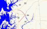
Maryland Route 309 is a state highway
in the U.S. state
of Maryland
. The state highway runs 18.5 miles (29.8 km) from U.S. Route 50
(US 50) in Easton
north to MD 213
south of Centreville
. MD 309 is a C-shaped highway that passes through northeastern Talbot County
and southeastern Queen Anne's County
, connecting Easton and Centreville with Queen Anne
, where the highway intersects MD 404
. MD 309 was originally designated along the highway between Easton and Queen Anne. The highway was constructed south from Queen Anne to Cordova
in the late 1920s along MD 303
's current course and from Cordova to Easton in the early 1930s. In 1955, MD 309 gained its northern segment by assuming MD 303, which originally followed the Queen Anne–Centreville portion of the present MD 309. When MD 309 moved to a new alignment between Cordova and Queen Anne in the early 1960s, MD 303 was assigned to the old alignment.
in Easton. The state highway heads east as two-lane Black Dog Alley for a short distance before turning northeast onto Cordova Road and leaving the town of Easton. MD 309 heads north through a mix of farmland and forest parallel to the abandoned railroad grade of the Easton–Clayton
branch of the Maryland and Delaware Railroad
. After passing through the village of Cordova, the state highway intersects MD 303 (Tappers Corner Road). MD 309 veers away from the railroad grade, crosses Norwich Creek, and intersects MD 404 ALT west of Queen Anne before entering Queen Anne's County at the intersection with Park Avenue and Flowers Road. At the intersection with MD 303 (Main Street), MD 309 turns northwest onto Starr Road and intersects MD 404 (Queen Annes Highway). North of Queen Anne, the state highway traverses farmland, meets the southern end of MD 481
(Damsontown Road), and passes through the hamlet of Starr before reaching its northern terminus at MD 213 (Centreville Road) south of Centreville.
State highway
State highway, state road or state route can refer to one of three related concepts, two of them related to a state or provincial government in a country that is divided into states or provinces :#A...
in the U.S. state
U.S. state
A U.S. state is any one of the 50 federated states of the United States of America that share sovereignty with the federal government. Because of this shared sovereignty, an American is a citizen both of the federal entity and of his or her state of domicile. Four states use the official title of...
of Maryland
Maryland
Maryland is a U.S. state located in the Mid Atlantic region of the United States, bordering Virginia, West Virginia, and the District of Columbia to its south and west; Pennsylvania to its north; and Delaware to its east...
. The state highway runs 18.5 miles (29.8 km) from U.S. Route 50
U.S. Route 50 in Maryland
U.S. Route 50 is a major east–west route of the U.S. Highway system, stretching just over from Ocean City, Maryland on the Atlantic Ocean to West Sacramento, California. In the U.S. state of Maryland, US 50 exists in two sections. The longer of these serves as a major route connecting...
(US 50) in Easton
Easton, Maryland
Easton, founded 1710, is a town within the Easton District of Talbot County, Maryland, United States. The population was 11,708 at the 2000 census, and 14,677 according to current July 2008 census estimates. It is the county seat of Talbot County. The primary ZIP Code is 21601, and the...
north to MD 213
Maryland Route 213
Maryland Route 213 is a state highway located on the Eastern Shore of Maryland in the United States. The route runs from Maryland Route 662 in Wye Mills, Queen Anne's County north to the Pennsylvania border in Cecil County, where it continues into that state as Pennsylvania Route 841...
south of Centreville
Centreville, Maryland
Centreville is an incorporated town in Queen Anne's County, Maryland, United States. Incorporated in 1794, it is the county seat of Queen Anne's County. The population was 1,970 at the 2000 census. The ZIP code is 21617 and the area code is 410. The local telephone exchange is 758...
. MD 309 is a C-shaped highway that passes through northeastern Talbot County
Talbot County, Maryland
-2010:Whereas according to the 2010 U.S. Census Bureau:*81.4% White*12.8% Black*0.2% Native American*1.2% Asian*0.1% Native Hawaiian or Pacific Islander*1.6% Two or more races*2.7% Other races*5.5% Hispanic or Latino -2000:...
and southeastern Queen Anne's County
Queen Anne's County, Maryland
Queen Anne's County is a county located on the Eastern Shore of the U.S. state of Maryland.As of 2010, the population was 47,798. Its county seat and most populous municipality is Centreville. The census-designated place of Stevensville is the county's most populous place...
, connecting Easton and Centreville with Queen Anne
Queen Anne, Maryland
Queen Anne is a town in Queen Anne's and Talbot counties in the U.S. state of Maryland. The population was 176 at the 2000 census.-Geography:Queen Anne is located at ....
, where the highway intersects MD 404
Maryland Route 404
Maryland Route 404 is a major highway on Maryland's Eastern Shore in the United States. It runs from Maryland Route 662 in Wye Mills on the border of Queen Anne's and Talbot Counties, southeast to the Delaware state line in Caroline County, where the road continues as Delaware Route 404 to Nassau...
. MD 309 was originally designated along the highway between Easton and Queen Anne. The highway was constructed south from Queen Anne to Cordova
Cordova, Maryland
Cordova is a census-designated place in Talbot County, Maryland, United States. The population was 592 at the 2000 census.-Geography:Cordova is located at ....
in the late 1920s along MD 303
Maryland Route 303
Maryland Route 303 is a state highway in the U.S. state of Maryland. The state highway runs from MD 309 in Cordova north to MD 404 in Queen Anne. MD 303 is an L-shaped highway that passes through the northeast corner of Talbot County and the southeast corner of Queen Anne's County. The state...
's current course and from Cordova to Easton in the early 1930s. In 1955, MD 309 gained its northern segment by assuming MD 303, which originally followed the Queen Anne–Centreville portion of the present MD 309. When MD 309 moved to a new alignment between Cordova and Queen Anne in the early 1960s, MD 303 was assigned to the old alignment.
Route description
MD 309 begins at an intersection with US 50 (Ocean Gateway) opposite Airport Road to the east of Easton AirportEaston Airport (Maryland)
Easton Airport , also known as Newnam Field, is a county-owned, public-use airport located two nautical miles north of the central business district of Easton, a town in Talbot County, Maryland, United States....
in Easton. The state highway heads east as two-lane Black Dog Alley for a short distance before turning northeast onto Cordova Road and leaving the town of Easton. MD 309 heads north through a mix of farmland and forest parallel to the abandoned railroad grade of the Easton–Clayton
Clayton, Delaware
Clayton is a town in Kent and New Castle counties in the U.S. state of Delaware. Located almost entirely in Kent County, it is part of the Dover, Delaware Metropolitan Statistical Area. The population was 2.918 at the 2010 census.-Geography:...
branch of the Maryland and Delaware Railroad
Maryland and Delaware Railroad
The Maryland and Delaware Railroad Company is a Class III short-line railroad, formed in 1977 to operate several branch lines of the former Penn Central Railroad in both Maryland and Delaware. These branches were omitted from the system plan for Conrail in 1976 and would have been discontinued...
. After passing through the village of Cordova, the state highway intersects MD 303 (Tappers Corner Road). MD 309 veers away from the railroad grade, crosses Norwich Creek, and intersects MD 404 ALT west of Queen Anne before entering Queen Anne's County at the intersection with Park Avenue and Flowers Road. At the intersection with MD 303 (Main Street), MD 309 turns northwest onto Starr Road and intersects MD 404 (Queen Annes Highway). North of Queen Anne, the state highway traverses farmland, meets the southern end of MD 481
Maryland Route 481
Maryland Route 481 is a state highway in the U.S. state of Maryland. Known as Damsontown Road, the state highway runs from MD 309 near Queen Anne north to MD 304 in Ruthsburg...
(Damsontown Road), and passes through the hamlet of Starr before reaching its northern terminus at MD 213 (Centreville Road) south of Centreville.
History
MD 309 originally consisted of the highway between Easton and Queen Anne. The highway from Queen Anne to south of Centreville was originally MD 303. A small piece of MD 309 was paved south of Queen Anne by 1921. Construction of the remainder of the highway to Cordova began in 1925 and was completed in 1929. The Cordova–Easton section was completed by 1933. In 1955, MD 309 assumed the length of MD 303 north to near Centreville. A present alignment of MD 309 opened between Cordova and Queen Anne in 1960; the old highway became the second edition of MD 303 in 1961. The southernmost portion of MD 309 was moved from Cordova Road to Black Dog Alley in 1995.Junction list
| County | Location | Mile |
Intersection | Notes |
|---|---|---|---|---|
| Talbot Talbot County, Maryland -2010:Whereas according to the 2010 U.S. Census Bureau:*81.4% White*12.8% Black*0.2% Native American*1.2% Asian*0.1% Native Hawaiian or Pacific Islander*1.6% Two or more races*2.7% Other races*5.5% Hispanic or Latino -2000:... |
Easton Easton, Maryland Easton, founded 1710, is a town within the Easton District of Talbot County, Maryland, United States. The population was 11,708 at the 2000 census, and 14,677 according to current July 2008 census estimates. It is the county seat of Talbot County. The primary ZIP Code is 21601, and the... |
0.00 | Southern terminus | |
| 0.13 | Black Dog Alley east / Cordova Road south | MD 309 turns northeast onto Cordova Road | ||
| Cordova Cordova, Maryland Cordova is a census-designated place in Talbot County, Maryland, United States. The population was 592 at the 2000 census.-Geography:Cordova is located at .... |
6.69 | Old alignment of MD 309 | ||
| Queen Anne Queen Anne, Maryland Queen Anne is a town in Queen Anne's and Talbot counties in the U.S. state of Maryland. The population was 176 at the 2000 census.-Geography:Queen Anne is located at .... |
9.22 | / Old Queen Anne Road west | Old alignment of MD 404 | |
| Queen Anne's Queen Anne's County, Maryland Queen Anne's County is a county located on the Eastern Shore of the U.S. state of Maryland.As of 2010, the population was 47,798. Its county seat and most populous municipality is Centreville. The census-designated place of Stevensville is the county's most populous place... |
9.62 | MD 309 turns northwest onto Starr Road | ||
| 9.74 | ||||
| 11.80 | ||||
| 18.50 | Northern terminus |