
Maryland Route 303
Encyclopedia
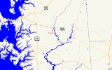
Maryland Route 303 is a state highway
in the U.S. state
of Maryland
. The state highway runs 4.2 miles (6.8 km) from MD 309
in Cordova
north to MD 404
in Queen Anne
. MD 303 is an L-shaped highway that passes through the northeast corner of Talbot County
and the southeast corner of Queen Anne's County
. The state highway also passes very close to the birthplace of Frederick Douglass
. MD 303 was originally designated along Starr Road between Queen Anne and U.S. Route 213 (US 213) south of Centreville
, while present MD 303 is part of the old alignment of MD 309. The original MD 303 was constructed in the late 1920s and early 1930s, with a gap near Starr filled in the late 1940s. MD 309 absorbed MD 303 in 1955. MD 303 was assigned to its present course in 1961.
branch of the Maryland and Delaware Railroad
and crossing a pair of branches of Tuckahoe Creek
. MD 303 turns north onto Lewistown Road at Tappers Corner very close to the birthplace of Frederick Douglass. After crossing Norwich Creek, the state highway has a short concurrency with MD 404 ALT (Talbot Avenue), during which MD 303 enters the town of Queen Anne. The state highway turns north onto Main Street to pass through the center of town and enters Queen Anne's County at the intersection with Park Avenue. MD 303 leaves the town after crossing the railroad grade and intersects MD 309, which heads southwest as Cordova Road and northwest as Starr Road. MD 303 turns northeast onto a one-way road to its northern terminus at MD 404 (Queen Annes Highway). Traffic from MD 404 must use MD 309 to access southbound MD 303.
) south of Centreville. Construction began in 1925 from Queen Anne. The highway was paved about 2 miles (3.2 km) north of Queen Anne by 1927. Another 1.5 miles (2.4 km) was paved toward Starr by 1930. By 1933, a second, unconnected section of MD 303 was constructed for 2 miles (3.2 km) east from US 213. The gap between the two sections was filled in two sections in 1949 and 1950. The first edition of MD 303 was assumed by MD 309 in 1955 when the latter highway was extended north from its terminus in Queen Anne to US 213. MD 303 was assigned to the old alignment of MD 309 between Cordova and Queen Anne in 1961 following the construction of MD 309's present alignment between Cordova and Queen Anne that parallels the railroad grade. The section of MD 303 between MD 309 and MD 404 became one-way northbound in 2004.
!County
!Location
!Mile
!Intersection
!Notes
|-
|rowspan=4|Talbot
|Cordova
|0.00
|
|Southern terminus
|-
|rowspan=1|Tappers Corner
|1.39
|Lewistown Road south – Matthews
|MD 303 turns north onto Lewistown Road
|-
|rowspan=4|Queen Anne
|3.58
|
|South end of concurrency with MD 404 ALT
|-
|3.66
|
|North end of concurrency with MD 404 ALT
|-
|rowspan=2|Queen Anne's
|4.03
|
|MD 309 forms southwest and northwest legs of intersection; northbound MD 303 turns northeast onto one-way road
|-
|4.20
|
|Northern terminus; traffic from MD 404 uses MD 309 to access southbound MD 303
State highway
State highway, state road or state route can refer to one of three related concepts, two of them related to a state or provincial government in a country that is divided into states or provinces :#A...
in the U.S. state
U.S. state
A U.S. state is any one of the 50 federated states of the United States of America that share sovereignty with the federal government. Because of this shared sovereignty, an American is a citizen both of the federal entity and of his or her state of domicile. Four states use the official title of...
of Maryland
Maryland
Maryland is a U.S. state located in the Mid Atlantic region of the United States, bordering Virginia, West Virginia, and the District of Columbia to its south and west; Pennsylvania to its north; and Delaware to its east...
. The state highway runs 4.2 miles (6.8 km) from MD 309
Maryland Route 309
Maryland Route 309 is a state highway in the U.S. state of Maryland. The state highway runs from U.S. Route 50 in Easton north to MD 213 south of Centreville. MD 309 is a C-shaped highway that passes through northeastern Talbot County and southeastern Queen Anne's County, connecting Easton and...
in Cordova
Cordova, Maryland
Cordova is a census-designated place in Talbot County, Maryland, United States. The population was 592 at the 2000 census.-Geography:Cordova is located at ....
north to MD 404
Maryland Route 404
Maryland Route 404 is a major highway on Maryland's Eastern Shore in the United States. It runs from Maryland Route 662 in Wye Mills on the border of Queen Anne's and Talbot Counties, southeast to the Delaware state line in Caroline County, where the road continues as Delaware Route 404 to Nassau...
in Queen Anne
Queen Anne, Maryland
Queen Anne is a town in Queen Anne's and Talbot counties in the U.S. state of Maryland. The population was 176 at the 2000 census.-Geography:Queen Anne is located at ....
. MD 303 is an L-shaped highway that passes through the northeast corner of Talbot County
Talbot County, Maryland
-2010:Whereas according to the 2010 U.S. Census Bureau:*81.4% White*12.8% Black*0.2% Native American*1.2% Asian*0.1% Native Hawaiian or Pacific Islander*1.6% Two or more races*2.7% Other races*5.5% Hispanic or Latino -2000:...
and the southeast corner of Queen Anne's County
Queen Anne's County, Maryland
Queen Anne's County is a county located on the Eastern Shore of the U.S. state of Maryland.As of 2010, the population was 47,798. Its county seat and most populous municipality is Centreville. The census-designated place of Stevensville is the county's most populous place...
. The state highway also passes very close to the birthplace of Frederick Douglass
Frederick Douglass
Frederick Douglass was an American social reformer, orator, writer and statesman. After escaping from slavery, he became a leader of the abolitionist movement, gaining note for his dazzling oratory and incisive antislavery writing...
. MD 303 was originally designated along Starr Road between Queen Anne and U.S. Route 213 (US 213) south of Centreville
Centreville, Maryland
Centreville is an incorporated town in Queen Anne's County, Maryland, United States. Incorporated in 1794, it is the county seat of Queen Anne's County. The population was 1,970 at the 2000 census. The ZIP code is 21617 and the area code is 410. The local telephone exchange is 758...
, while present MD 303 is part of the old alignment of MD 309. The original MD 303 was constructed in the late 1920s and early 1930s, with a gap near Starr filled in the late 1940s. MD 309 absorbed MD 303 in 1955. MD 303 was assigned to its present course in 1961.
Route description
MD 303 begins at an intersection with MD 309 (Cordova Road) a short distance north of the village of Cordova. The state highway heads east as two-lane Tappers Corner Road, passing under the abandoned railroad grade of the Easton–ClaytonClayton, Delaware
Clayton is a town in Kent and New Castle counties in the U.S. state of Delaware. Located almost entirely in Kent County, it is part of the Dover, Delaware Metropolitan Statistical Area. The population was 2.918 at the 2010 census.-Geography:...
branch of the Maryland and Delaware Railroad
Maryland and Delaware Railroad
The Maryland and Delaware Railroad Company is a Class III short-line railroad, formed in 1977 to operate several branch lines of the former Penn Central Railroad in both Maryland and Delaware. These branches were omitted from the system plan for Conrail in 1976 and would have been discontinued...
and crossing a pair of branches of Tuckahoe Creek
Tuckahoe Creek
Tuckahoe Creek is a tributary of the Choptank River on Maryland's Eastern Shore. It is sometimes referred to as the Tuckahoe River. Upstream of Hillsboro, it forms the boundary between Caroline County and Queen Anne's County, passing through Tuckahoe State Park and dividing the small towns of...
. MD 303 turns north onto Lewistown Road at Tappers Corner very close to the birthplace of Frederick Douglass. After crossing Norwich Creek, the state highway has a short concurrency with MD 404 ALT (Talbot Avenue), during which MD 303 enters the town of Queen Anne. The state highway turns north onto Main Street to pass through the center of town and enters Queen Anne's County at the intersection with Park Avenue. MD 303 leaves the town after crossing the railroad grade and intersects MD 309, which heads southwest as Cordova Road and northwest as Starr Road. MD 303 turns northeast onto a one-way road to its northern terminus at MD 404 (Queen Annes Highway). Traffic from MD 404 must use MD 309 to access southbound MD 303.
History
The present MD 303 was originally part of MD 309. MD 303's first incarnation was between Queen Anne and US 213 (now MD 213Maryland Route 213
Maryland Route 213 is a state highway located on the Eastern Shore of Maryland in the United States. The route runs from Maryland Route 662 in Wye Mills, Queen Anne's County north to the Pennsylvania border in Cecil County, where it continues into that state as Pennsylvania Route 841...
) south of Centreville. Construction began in 1925 from Queen Anne. The highway was paved about 2 miles (3.2 km) north of Queen Anne by 1927. Another 1.5 miles (2.4 km) was paved toward Starr by 1930. By 1933, a second, unconnected section of MD 303 was constructed for 2 miles (3.2 km) east from US 213. The gap between the two sections was filled in two sections in 1949 and 1950. The first edition of MD 303 was assumed by MD 309 in 1955 when the latter highway was extended north from its terminus in Queen Anne to US 213. MD 303 was assigned to the old alignment of MD 309 between Cordova and Queen Anne in 1961 following the construction of MD 309's present alignment between Cordova and Queen Anne that parallels the railroad grade. The section of MD 303 between MD 309 and MD 404 became one-way northbound in 2004.
Junction list
{|class=wikitable!County
!Location
!Mile
!Intersection
!Notes
|-
|rowspan=4|Talbot
Talbot County, Maryland
-2010:Whereas according to the 2010 U.S. Census Bureau:*81.4% White*12.8% Black*0.2% Native American*1.2% Asian*0.1% Native Hawaiian or Pacific Islander*1.6% Two or more races*2.7% Other races*5.5% Hispanic or Latino -2000:...
|Cordova
Cordova, Maryland
Cordova is a census-designated place in Talbot County, Maryland, United States. The population was 592 at the 2000 census.-Geography:Cordova is located at ....
|0.00
|
|Southern terminus
|-
|rowspan=1|Tappers Corner
|1.39
|Lewistown Road south – Matthews
Matthews, Maryland
Matthews is an unincorporated community in Talbot County, Maryland, United States.-References:...
|MD 303 turns north onto Lewistown Road
|-
|rowspan=4|Queen Anne
Queen Anne, Maryland
Queen Anne is a town in Queen Anne's and Talbot counties in the U.S. state of Maryland. The population was 176 at the 2000 census.-Geography:Queen Anne is located at ....
|3.58
|
|South end of concurrency with MD 404 ALT
|-
|3.66
|
|North end of concurrency with MD 404 ALT
|-
|rowspan=2|Queen Anne's
Queen Anne's County, Maryland
Queen Anne's County is a county located on the Eastern Shore of the U.S. state of Maryland.As of 2010, the population was 47,798. Its county seat and most populous municipality is Centreville. The census-designated place of Stevensville is the county's most populous place...
|4.03
|
|MD 309 forms southwest and northwest legs of intersection; northbound MD 303 turns northeast onto one-way road
|-
|4.20
|
|Northern terminus; traffic from MD 404 uses MD 309 to access southbound MD 303