
Maryland Route 223
Encyclopedia
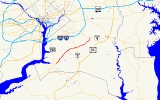
Maryland Route 223 is a state highway
in the U.S. state of Maryland
. The state highway runs 12.65 miles (20.4 km) from Livingston Road in Piscataway
north to Mellwood Road in Mellwood. MD 223 passes through suburban areas of southern Prince George's County
, including the community of Woodyard south of Andrews Air Force Base
between MD 5
in Clinton
and MD 4
in Mellwood.
, heads south toward Accokeek
and north toward Fort Washington
. The state highway heads northeast as two-lane Floral Park Road. MD 223 turns north onto Piscataway Road at the four-way intersection with that highway; Floral Park Road continues east toward Brandywine
. The state highway crosses Piscataway Creek
and continues northeast through a mix of forest and residential subdivisions. MD 223 intersects Tippett Road, which heads south toward the historic home Wyoming
, next to Washington Executive Airport
. The state highway expands to a four-lane undivided highway as it enters Clinton, where the highway passes Surrattsville High School
and the Surratt House Museum
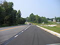
and intersects the old alignment of MD 5, which heads north as Old Branch Avenue and south as Brandywine Road. MD 223 enters a commercial area and expands to a divided highway around its single-point urban interchange
with MD 5 (Branch Avenue).
 MD 223 continues east from MD 5 as two-lane Woodyard Road. The state highway intersects Dangerfield Road and Old Alexandria Ferry Road in the hamlet of Coles Corner. MD 223 continues east to the community of Woodyard, where the highway passes the historic home His Lordship's Kindness
and cross Piscataway Creek again. MD 223 turns north to continue on Woodyard Road at its intersection with Rosaryville Road, which heads southeast toward the village of Rosaryville
and Rosaryville State Park
. The state highway gradually curves to the north through the community of Mellwood. MD 223 expands to a four-lane divided highway right before its intersection with the old alignment of MD 4, Marlboro Pike. The state highway, now named Mellwood Road, meets MD 4 (Pennsylvania Avenue) at a partial cloverleaf interchange, then immediately intersects Old Marlboro Pike, which leads east to the historic home Melwood Park
. MD 223 reaches its northern terminus immediately to the north when the divided highway rapidly reduces to a very narrow, forest-lined, two-lane county highway.
.
{|class=wikitable
!Location
!Mile
!Intersection
!Notes
|-
|rowspan=2|Piscataway
|0.00
|Livingston Road – Accokeek
, Fort Washington
|Southern terminus
|-
|0.63
|Piscataway Road south / Floral Park Road east – Brandywine
|MD 223 turns north onto Piscataway Road
|-
|Clinton
|7.45
|
|Single-point urban interchange
|-
|Woodyard
|10.12
|Rosaryville Road south – Rosaryville
|MD 223 turns north to remain on Woodyard Road
|-
|rowspan=2|Mellwood
|12.48
|
|Partial cloverleaf interchange
|-
|12.65
|Mellwood Road north
|Northern terminus
State highway
State highway, state road or state route can refer to one of three related concepts, two of them related to a state or provincial government in a country that is divided into states or provinces :#A...
in the U.S. state of Maryland
Maryland
Maryland is a U.S. state located in the Mid Atlantic region of the United States, bordering Virginia, West Virginia, and the District of Columbia to its south and west; Pennsylvania to its north; and Delaware to its east...
. The state highway runs 12.65 miles (20.4 km) from Livingston Road in Piscataway
Piscataway, Maryland
Piscataway is an unincorporated community in Prince George's County, Maryland, United States. It is one of the oldest European-colonized communities in the state...
north to Mellwood Road in Mellwood. MD 223 passes through suburban areas of southern Prince George's County
Prince George's County, Maryland
Prince George's County is a county located in the U.S. state of Maryland, immediately north, east, and south of Washington, DC. As of 2010, it has a population of 863,420 and is the wealthiest African-American majority county in the nation....
, including the community of Woodyard south of Andrews Air Force Base
Andrews Air Force Base
Joint Base Andrews is a United States military facility located in Prince George's County, Maryland. The facility is under the jurisdiction of the United States Air Force 11th Wing, Air Force District of Washington ....
between MD 5
Maryland Route 5
Maryland Route 5 is a long state highway that runs north–south in the U.S. state of Maryland. The highway runs from Point Lookout in St. Mary's County north to the Washington, D.C. border in Suitland, Prince George's County....
in Clinton
Clinton, Maryland
Clinton is an unincorporated area and census-designated place in Prince George's County, Maryland, United States. Clinton was formerly known as Surrattsville until after the time of the American Civil War. The population of Clinton was 26,064 at the 2000 census. However, as of 2007, there is an...
and MD 4
Maryland Route 4
Maryland Route 4 is a state highway in the U.S. state of Maryland. The state highway runs from MD 5 in Leonardtown north to Southern Avenue at the Washington, D.C. border, past which the highway continues as Pennsylvania Avenue...
in Mellwood.
Route description
MD 223 begins at an intersection with county-maintained Livingston Road in Piscataway. Livingston Road, which was formerly part of MD 224Maryland Route 224
Maryland Route 224 is a state highway in the U.S. state of Maryland. The state highway runs from MD 6 in Riverside north to MD 227 in Pomonkey. MD 224 is one of the main highways of southwestern Charles County, connecting several villages, state parks, and preserves along the Potomac River and...
, heads south toward Accokeek
Accokeek, Maryland
Accokeek is an unincorporated area and census-designated place in Prince George's County, Maryland, United States, located about 8.5 miles southwest of Washington, D.C. The population was 7,349 at the 2000 census. It is home to Piscataway Park....
and north toward Fort Washington
Fort Washington, Maryland
Fort Washington, Maryland is an unincorporated area and census-designated place in Prince George's County, Maryland in the suburbs of the capital city of the United States of America, Washington, D.C., south of the downtown district. It is a prosperous community with an African American majority...
. The state highway heads northeast as two-lane Floral Park Road. MD 223 turns north onto Piscataway Road at the four-way intersection with that highway; Floral Park Road continues east toward Brandywine
Brandywine, Maryland
Brandywine is an unincorporated area and census-designated place in Prince George's County, Maryland, United States, although the postal delivery area includes part of Charles County as well near Malcolm....
. The state highway crosses Piscataway Creek
Piscataway Creek
Piscataway Creek is an tributary of the Potomac River in Prince George's County, Maryland. The creek is a tidal arm of the Potomac for its final , entering the Potomac at Fort Washington Park. Tinkers Creek is a tributary to Piscataway Creek, converging from the north upstream of the mouth of the...
and continues northeast through a mix of forest and residential subdivisions. MD 223 intersects Tippett Road, which heads south toward the historic home Wyoming
Wyoming (Clinton, Maryland)
Wyoming is a frame historic house located in Clinton in Prince George's County, Maryland, United States. It consists of three separate and distinct sections: the main block built in the third quarter of the 18th century, a ca. 1800 kitchen, and a connecting two-bay section of c. 1850...
, next to Washington Executive Airport
Washington Executive Airport
Washington Executive Airport , also known as Hyde Field, is a public use general aviation airport located two miles southwest of the central business district of Clinton, in Prince Georges County, Maryland, USA...
. The state highway expands to a four-lane undivided highway as it enters Clinton, where the highway passes Surrattsville High School
Surrattsville High School
Surrattsville High School or SHS is a public high school located in Clinton, Maryland and is a part of the Prince George's County Public School System in Prince George's County, Maryland. The school educates about 1,100 children and teenagers in grades 9 through 12...
and the Surratt House Museum
Surratt House Museum
The Surratt House is a historic home located at 9110 Brandywine Road in Clinton , Prince George's County, Maryland, United States. It is a 2-story 19th-century wood-frame structure with clapboarding...
and intersects the old alignment of MD 5, which heads north as Old Branch Avenue and south as Brandywine Road. MD 223 enters a commercial area and expands to a divided highway around its single-point urban interchange
Single-point urban interchange
A single-point urban interchange , also called a single-point interchange or single-point diamond interchange , is a type of highway interchange...
with MD 5 (Branch Avenue).
His Lordship's Kindness
His Lordship's Kindness was built in the 1780s for Prince Georges County planter Robert Darnall near Clinton, Maryland. The five-part Georgian mansion, also known as Poplar Hill, retains a number of subsidiary buildings including a slave's hospital and a dovecote.-History:Colonel Henry Darnall was...
and cross Piscataway Creek again. MD 223 turns north to continue on Woodyard Road at its intersection with Rosaryville Road, which heads southeast toward the village of Rosaryville
Rosaryville, Maryland
Rosaryville is an unincorporated area and census-designated place in Prince George's County, Maryland, United States beside U.S. Highway 301. The population was 12,322 at the 2000 census, including housing developments and rural open space. It was named for a local Roman Catholic church...
and Rosaryville State Park
Rosaryville State Park
Rosaryville State Park is a state park in Greater Upper Marlboro, Prince George's County, Maryland. It includes the restored Mount Airy Mansion, an event facility that Pineapple Alley Catering, Inc. operates...
. The state highway gradually curves to the north through the community of Mellwood. MD 223 expands to a four-lane divided highway right before its intersection with the old alignment of MD 4, Marlboro Pike. The state highway, now named Mellwood Road, meets MD 4 (Pennsylvania Avenue) at a partial cloverleaf interchange, then immediately intersects Old Marlboro Pike, which leads east to the historic home Melwood Park
Melwood Park
Melwood Park is a historic home located near Upper Marlboro in Prince George's County, Maryland, United States. It is a -story, Flemish bond brick structure, with Georgian details. As of 2009, it is undergoing an extensive restoration. This unique dwelling was visited by George Washington on...
. MD 223 reaches its northern terminus immediately to the north when the divided highway rapidly reduces to a very narrow, forest-lined, two-lane county highway.
Junction list
The entire route is located in Prince George's CountyPrince George's County, Maryland
Prince George's County is a county located in the U.S. state of Maryland, immediately north, east, and south of Washington, DC. As of 2010, it has a population of 863,420 and is the wealthiest African-American majority county in the nation....
.
{|class=wikitable
!Location
!Mile
!Intersection
!Notes
|-
|rowspan=2|Piscataway
Piscataway, Maryland
Piscataway is an unincorporated community in Prince George's County, Maryland, United States. It is one of the oldest European-colonized communities in the state...
|0.00
|Livingston Road – Accokeek
Accokeek, Maryland
Accokeek is an unincorporated area and census-designated place in Prince George's County, Maryland, United States, located about 8.5 miles southwest of Washington, D.C. The population was 7,349 at the 2000 census. It is home to Piscataway Park....
, Fort Washington
Fort Washington, Maryland
Fort Washington, Maryland is an unincorporated area and census-designated place in Prince George's County, Maryland in the suburbs of the capital city of the United States of America, Washington, D.C., south of the downtown district. It is a prosperous community with an African American majority...
|Southern terminus
|-
|0.63
|Piscataway Road south / Floral Park Road east – Brandywine
Brandywine, Maryland
Brandywine is an unincorporated area and census-designated place in Prince George's County, Maryland, United States, although the postal delivery area includes part of Charles County as well near Malcolm....
|MD 223 turns north onto Piscataway Road
|-
|Clinton
Clinton, Maryland
Clinton is an unincorporated area and census-designated place in Prince George's County, Maryland, United States. Clinton was formerly known as Surrattsville until after the time of the American Civil War. The population of Clinton was 26,064 at the 2000 census. However, as of 2007, there is an...
|7.45
|
|Single-point urban interchange
Single-point urban interchange
A single-point urban interchange , also called a single-point interchange or single-point diamond interchange , is a type of highway interchange...
|-
|Woodyard
|10.12
|Rosaryville Road south – Rosaryville
Rosaryville, Maryland
Rosaryville is an unincorporated area and census-designated place in Prince George's County, Maryland, United States beside U.S. Highway 301. The population was 12,322 at the 2000 census, including housing developments and rural open space. It was named for a local Roman Catholic church...
|MD 223 turns north to remain on Woodyard Road
|-
|rowspan=2|Mellwood
|12.48
|
|Partial cloverleaf interchange
|-
|12.65
|Mellwood Road north
|Northern terminus