
Maryland Route 195
Encyclopedia
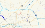
Maryland Route 195 is a state highway
in the U.S. state
of Maryland
. Known as Carroll Avenue, the state highway runs 1.9 mi (3.1 km) from Eastern Avenue
at the border of Washington, D.C.
north to Maryland Route 193
in Takoma Park
. MD 195 provides access to Washington Adventist University, Washington Adventist Hospital
, the Takoma Park Historic District, and the Takoma
station of the Washington Metro
just south of the border in Washington. The state highway was finished in the late 1920s but its most notable feature, the Carroll Avenue Bridge over Sligo Creek
, was completed in 1932.
at an intersection with Eastern Avenue
. The road continues west as Carroll Street into the Takoma neighborhood of Washington, where it provides access to the Takoma
station on the Red Line
of the Washington Metro
.
MD 195 heads east as a two-lane street with a speed limit of 25 mph (40.2 km/h) through the Takoma Park Historic District
. At Laurel Avenue, which is closed for the Takoma Park Farmers Market every Sunday, the state highway turns north to continue on Carroll Avenue through businesses and closely spaced residences within Old Town Takoma Park. After passing a pedestrian traffic signal at Tulip Avenue, the state highway turns north toward Takoma Junction. At Takoma Junction, MD 195 intersects Maryland Route 410
(Philadelphia Avenue) at the Takoma Park Volunteer Fire Department and joins that state highway in a concurrency
. After 400 feet (121.9 m), the two routes diverge, with MD 410 heading east and MD 195 heading north.
MD 195 continues north through a residential area. At Lincoln Avenue, the state highway turns northeast and starts heading downhill into the valley of Sligo Creek
. Where Old Carroll Street continues straight down the hill to access Sligo Creek Parkway
, MD 195 veers north and crosses the parkway, the creek, and the Sligo Creek Trail
on the Carroll Avenue Bridge, a triple span reinforced concrete, open spandrel arch bridge completed in 1932. The state highway heads through a moderate S-curve in which it passes the main entrance to Washington Adventist Hospital
and adjoins the campus of Washington Adventist University, then intersects Maryland Route 787
(Flower Avenue).
After crossing MD 787, MD 195 leaves the university campus and heads downhill northeast toward Long Branch, a tributary of Northwest Branch
. The state highway is maintained for 0.21 mile (0.3379614 km) by the city of Takoma Park between MD 787 and the city limit north of Garland Avenue. After leaving the corporate limits, the speed limit increases to 30 mph (48.3 km/h). At the bottom of the hill, MD 195 intersects Long Branch Parkway at a flashing signal and crosses the stream on a bridge rebuilt in 2005, then heads uphill and curves north. Between Glenside Drive and Chester Street, the state highway parallels unsigned MD 195A, a service road for adjoining residences. After passing Chester Street, MD 195 acquires a narrow grassy median for short stretches on the way to its northern terminus. After passing the Davis-Warner House
and Merrimac Drive, the state highway reaches its north end at an oblique intersection with Maryland Route 193
(University Boulevard). Since a left turn is prohibited from MD 193 west to MD 195 south, Merrimac Drive is used for that missing connection. Carroll Avenue continues north as a county-maintained street that ends at Maryland Route 320
(Piney Branch Road).
MD 195 has an average annual daily traffic figure of 9892 vehicles between Laurel Avenue and MD 410, as well as an AADT of 13912 between Long Branch Parkway and MD 193.
in the area was built just to the east of the present bridge. This bridge was part of an old road between Washington
and Sandy Spring
that roughly followed present day MD 195, MD 320, and MD 650 north to Ashton
. The street itself was named for Samuel S. Carroll
, the owner of the land around present day Takoma Junction prior to its purchase by Benjamin Franklin Gilbert
in 1883 to create his planned suburb of Takoma Park
. A reinforced concrete bridge over Sligo Creek was built on the location of the present bridge in 1909, connecting Washington and the Washington Sanatarium, which had been completed in 1907. MD 195 was paved between 1927 and 1930 along its entire length, including the city-maintained portion north of Flower Avenue. The 1909 bridge over Sligo Creek was replaced by the current bridge in 1932.
in Montgomery County
.
State highway
State highway, state road or state route can refer to one of three related concepts, two of them related to a state or provincial government in a country that is divided into states or provinces :#A...
in the U.S. state
U.S. state
A U.S. state is any one of the 50 federated states of the United States of America that share sovereignty with the federal government. Because of this shared sovereignty, an American is a citizen both of the federal entity and of his or her state of domicile. Four states use the official title of...
of Maryland
Maryland
Maryland is a U.S. state located in the Mid Atlantic region of the United States, bordering Virginia, West Virginia, and the District of Columbia to its south and west; Pennsylvania to its north; and Delaware to its east...
. Known as Carroll Avenue, the state highway runs 1.9 mi (3.1 km) from Eastern Avenue
Eastern Avenue (Washington, D.C.)
Eastern Avenue is one of three boundary streets between Washington, D.C., and the state of Maryland. It follows a northwest-to-southeast line, beginning at the intersection of 16th Street NW and Colesville Road...
at the border of Washington, D.C.
Washington, D.C.
Washington, D.C., formally the District of Columbia and commonly referred to as Washington, "the District", or simply D.C., is the capital of the United States. On July 16, 1790, the United States Congress approved the creation of a permanent national capital as permitted by the U.S. Constitution....
north to Maryland Route 193
Maryland Route 193
Maryland Route 193 is a state highway in the U.S. state of Maryland. Known for most of its length as University Boulevard and Greenbelt Road, the state highway runs from MD 185 in Kensington east to MD 202 in Greater Upper Marlboro...
in Takoma Park
Takoma Park, Maryland
Takoma Park is a city in Montgomery County, Maryland, United States. It is a suburb of Washington, D.C., and part of the Washington Metropolitan Area. Founded in 1883 and incorporated in 1890, Takoma Park, informally called "Azalea City," is a Tree City USA and a nuclear-free zone...
. MD 195 provides access to Washington Adventist University, Washington Adventist Hospital
Washington Adventist Hospital
Washington Adventist Hospital is a 281-licensed bed acute care facility located in Takoma Park, Maryland. Washington Adventist Hospital provides a range of health services to the community such as cardiac & vascular care, maternity services, cancer care, surgical services and orthopedics and...
, the Takoma Park Historic District, and the Takoma
Takoma (Washington Metro)
Takoma is a Washington Metro station in Washington, D.C. on the Red Line. It is the last station within the District of Columbia on the eastern end of the line....
station of the Washington Metro
Washington Metro
The Washington Metro, commonly called Metro, and unofficially Metrorail, is the rapid transit system in Washington, D.C., United States, and its surrounding suburbs. It is administered by the Washington Metropolitan Area Transit Authority , which also operates Metrobus service under the Metro name...
just south of the border in Washington. The state highway was finished in the late 1920s but its most notable feature, the Carroll Avenue Bridge over Sligo Creek
Sligo Creek
Sligo Creek is a free-flowing tributary of the Northwest Branch of the Anacostia River in Maryland. The creek is approximately long, with a drainage area of about .- Geography :The creek rises in the Kemp Mill section of Silver Spring in Montgomery County and...
, was completed in 1932.
Route description
Maryland Route 195 begins at the border of Washington, D.C.Washington, D.C.
Washington, D.C., formally the District of Columbia and commonly referred to as Washington, "the District", or simply D.C., is the capital of the United States. On July 16, 1790, the United States Congress approved the creation of a permanent national capital as permitted by the U.S. Constitution....
at an intersection with Eastern Avenue
Eastern Avenue (Washington, D.C.)
Eastern Avenue is one of three boundary streets between Washington, D.C., and the state of Maryland. It follows a northwest-to-southeast line, beginning at the intersection of 16th Street NW and Colesville Road...
. The road continues west as Carroll Street into the Takoma neighborhood of Washington, where it provides access to the Takoma
Takoma (Washington Metro)
Takoma is a Washington Metro station in Washington, D.C. on the Red Line. It is the last station within the District of Columbia on the eastern end of the line....
station on the Red Line
Red Line (Washington Metro)
The Red Line of the Washington Metro is a rail rapid transit service operating between 27 stations in Montgomery County, Maryland and the District of Columbia, United States. It is a primary line through downtown Washington, and the oldest and busiest line in the system...
of the Washington Metro
Washington Metro
The Washington Metro, commonly called Metro, and unofficially Metrorail, is the rapid transit system in Washington, D.C., United States, and its surrounding suburbs. It is administered by the Washington Metropolitan Area Transit Authority , which also operates Metrobus service under the Metro name...
.
MD 195 heads east as a two-lane street with a speed limit of 25 mph (40.2 km/h) through the Takoma Park Historic District
Takoma Park Historic District (Takoma Park, Maryland)
The Takoma Park Historic District is a national historic district located at Takoma Park, Montgomery County, Maryland. The district area was platted in 1883 by developer Benjamin Franklin Gilbert, and promoted for its natural environment and healthy setting. Originally an early railroad suburb, the...
. At Laurel Avenue, which is closed for the Takoma Park Farmers Market every Sunday, the state highway turns north to continue on Carroll Avenue through businesses and closely spaced residences within Old Town Takoma Park. After passing a pedestrian traffic signal at Tulip Avenue, the state highway turns north toward Takoma Junction. At Takoma Junction, MD 195 intersects Maryland Route 410
Maryland Route 410
Maryland Route 410 is a state highway in the U.S. state of Maryland. Known for most of its length as East–West Highway, the highway runs from MD 355 in Bethesda east to Pennsy Drive in Landover Hills...
(Philadelphia Avenue) at the Takoma Park Volunteer Fire Department and joins that state highway in a concurrency
Concurrency (road)
A concurrency, overlap, or coincidence in a road network is an instance of one physical road bearing two or more different highway, motorway, or other route numbers...
. After 400 feet (121.9 m), the two routes diverge, with MD 410 heading east and MD 195 heading north.
MD 195 continues north through a residential area. At Lincoln Avenue, the state highway turns northeast and starts heading downhill into the valley of Sligo Creek
Sligo Creek
Sligo Creek is a free-flowing tributary of the Northwest Branch of the Anacostia River in Maryland. The creek is approximately long, with a drainage area of about .- Geography :The creek rises in the Kemp Mill section of Silver Spring in Montgomery County and...
. Where Old Carroll Street continues straight down the hill to access Sligo Creek Parkway
Sligo Creek Parkway
Sligo Creek Parkway is two-lane at-grade automobile parkway in Montgomery County in the U.S. state of Maryland. The two-lane parkway runs from Maryland Route 650 in Takoma Park through Silver Spring north to MD 193 in Maryland...
, MD 195 veers north and crosses the parkway, the creek, and the Sligo Creek Trail
Sligo Creek Trail
Sligo Creek Trail is a paved hiker-biker trail running along Sligo Creek in the suburbs of Washington, D.C. Most of the trail passes through tree-filled parkland. The trail and surrounding park is a popular place for locals to jog, walk, bicycle, roller-skate, and take their children to the...
on the Carroll Avenue Bridge, a triple span reinforced concrete, open spandrel arch bridge completed in 1932. The state highway heads through a moderate S-curve in which it passes the main entrance to Washington Adventist Hospital
Washington Adventist Hospital
Washington Adventist Hospital is a 281-licensed bed acute care facility located in Takoma Park, Maryland. Washington Adventist Hospital provides a range of health services to the community such as cardiac & vascular care, maternity services, cancer care, surgical services and orthopedics and...
and adjoins the campus of Washington Adventist University, then intersects Maryland Route 787
Maryland Route 787
Maryland Route 787 is a state highway in the U.S. state of Maryland. Known as Flower Avenue, the state highway runs from Maryland Route 195 in Takoma Park north to Maryland Route 320 in Takoma Park. MD 787 splits the campus of Washington Adventist University and is the main street of the area of...
(Flower Avenue).
After crossing MD 787, MD 195 leaves the university campus and heads downhill northeast toward Long Branch, a tributary of Northwest Branch
Northwest Branch Anacostia River
Northwest Branch Anacostia River is a free-flowing stream in Montgomery County and Prince George's County, Maryland. It is a tributary of the Anacostia River, which flows to the Potomac River and the Chesapeake Bay.-Course:...
. The state highway is maintained for 0.21 mile (0.3379614 km) by the city of Takoma Park between MD 787 and the city limit north of Garland Avenue. After leaving the corporate limits, the speed limit increases to 30 mph (48.3 km/h). At the bottom of the hill, MD 195 intersects Long Branch Parkway at a flashing signal and crosses the stream on a bridge rebuilt in 2005, then heads uphill and curves north. Between Glenside Drive and Chester Street, the state highway parallels unsigned MD 195A, a service road for adjoining residences. After passing Chester Street, MD 195 acquires a narrow grassy median for short stretches on the way to its northern terminus. After passing the Davis-Warner House
Davis-Warner House
Davis-Warner House is a historic home located at 8114 Carroll Avenue, Takoma Park, Montgomery County, Maryland. It is a large, three story frame Stick Style residence constructed about 1875. It is one of the oldest residences in Takoma Park, and one of the only surviving Eastlake Stick Style...
and Merrimac Drive, the state highway reaches its north end at an oblique intersection with Maryland Route 193
Maryland Route 193
Maryland Route 193 is a state highway in the U.S. state of Maryland. Known for most of its length as University Boulevard and Greenbelt Road, the state highway runs from MD 185 in Kensington east to MD 202 in Greater Upper Marlboro...
(University Boulevard). Since a left turn is prohibited from MD 193 west to MD 195 south, Merrimac Drive is used for that missing connection. Carroll Avenue continues north as a county-maintained street that ends at Maryland Route 320
Maryland Route 320
Maryland Route 320 is a state highway in the U.S. state of Maryland. Known as Piney Branch Road, the route runs from Eastern Avenue at the Washington, D.C. border north to Maryland Route 650 in Adelphi.-Route description:...
(Piney Branch Road).
MD 195 has an average annual daily traffic figure of 9892 vehicles between Laurel Avenue and MD 410, as well as an AADT of 13912 between Long Branch Parkway and MD 193.
History
Portions of Carroll Avenue date back to 1878, when the first bridge crossing Sligo CreekSligo Creek
Sligo Creek is a free-flowing tributary of the Northwest Branch of the Anacostia River in Maryland. The creek is approximately long, with a drainage area of about .- Geography :The creek rises in the Kemp Mill section of Silver Spring in Montgomery County and...
in the area was built just to the east of the present bridge. This bridge was part of an old road between Washington
Washington, D.C.
Washington, D.C., formally the District of Columbia and commonly referred to as Washington, "the District", or simply D.C., is the capital of the United States. On July 16, 1790, the United States Congress approved the creation of a permanent national capital as permitted by the U.S. Constitution....
and Sandy Spring
Sandy Spring, Maryland
Sandy Spring, Maryland is an unincorporated community in Montgomery County, Maryland.The community was founded by Quakers who arrived in the early 18th century searching for land where they could grow tobacco and corn. One of the very early land owners in the Sandy Spring area was Richard Snowden,...
that roughly followed present day MD 195, MD 320, and MD 650 north to Ashton
Ashton, Maryland
Ashton is an unincorporated area in Montgomery County, Maryland. The commercial center of Ashton lies at the junction of Route 108 and New Hampshire Avenue ....
. The street itself was named for Samuel S. Carroll
Samuel S. Carroll
Samuel Spriggs "Red" Carroll was a career officer in the United States Army who rose to the rank of brigadier general during the American Civil War...
, the owner of the land around present day Takoma Junction prior to its purchase by Benjamin Franklin Gilbert
Benjamin Franklin Gilbert
Benjamin Franklin Gilbert , an American real estate developer, was the founder of Takoma Park, Maryland, a suburb of Washington, D.C., and the city's first mayor. Gilbert was born in DeRuyter , New York, Madison County, New York....
in 1883 to create his planned suburb of Takoma Park
Takoma Park, Maryland
Takoma Park is a city in Montgomery County, Maryland, United States. It is a suburb of Washington, D.C., and part of the Washington Metropolitan Area. Founded in 1883 and incorporated in 1890, Takoma Park, informally called "Azalea City," is a Tree City USA and a nuclear-free zone...
. A reinforced concrete bridge over Sligo Creek was built on the location of the present bridge in 1909, connecting Washington and the Washington Sanatarium, which had been completed in 1907. MD 195 was paved between 1927 and 1930 along its entire length, including the city-maintained portion north of Flower Avenue. The 1909 bridge over Sligo Creek was replaced by the current bridge in 1932.
Junction list
The entire route is in Takoma ParkTakoma Park, Maryland
Takoma Park is a city in Montgomery County, Maryland, United States. It is a suburb of Washington, D.C., and part of the Washington Metropolitan Area. Founded in 1883 and incorporated in 1890, Takoma Park, informally called "Azalea City," is a Tree City USA and a nuclear-free zone...
in Montgomery County
Montgomery County, Maryland
Montgomery County is a county in the U.S. state of Maryland, situated just to the north of Washington, D.C., and southwest of the city of Baltimore. It is one of the most affluent counties in the United States, and has the highest percentage of residents over 25 years of age who hold post-graduate...
.
| Mile | Destinations | Notes |
|---|---|---|
| 0.00 | Eastern Avenue Eastern Avenue (Washington, D.C.) Eastern Avenue is one of three boundary streets between Washington, D.C., and the state of Maryland. It follows a northwest-to-southeast line, beginning at the intersection of 16th Street NW and Colesville Road... |
Southern terminus Road continues into Washington Washington, D.C. Washington, D.C., formally the District of Columbia and commonly referred to as Washington, "the District", or simply D.C., is the capital of the United States. On July 16, 1790, the United States Congress approved the creation of a permanent national capital as permitted by the U.S. Constitution.... as Carroll Street |
| 0.08 | Laurel Avenue | MD 195 turns north to remain on Carroll Avenue |
| 0.44 | Begin concurrency with MD 410 | |
| 0.52 | End concurrency with MD 410 | |
| 1.00 | Carroll Avenue Bridge over Sligo Creek Sligo Creek Sligo Creek is a free-flowing tributary of the Northwest Branch of the Anacostia River in Maryland. The creek is approximately long, with a drainage area of about .- Geography :The creek rises in the Kemp Mill section of Silver Spring in Montgomery County and... |
|
| 1.14 | ||
| 1.90 | Northern terminus Carroll Avenue continues north |
|