Marulan, New South Wales
Encyclopedia
Marulan is a small town in the Southern Tablelands
of New South Wales
, Australia in the Goulburn Mulwaree Council
Local Government Area. It is located south-west of Sydney on the Hume Highway
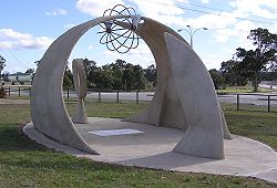
, although it bypasses the town proper. Marulan lies on the 150th meridian east
. It has a railway station
on CityRail
's Southern Highlands line
. Marulan was previously known as Mooroowoolen. At the 2006 census
, Marulan had a population of 540 people.
and James Meehan
reached "the Goulburn plains"
for the first time. Governor Lachlan Macquarie
ordered the construction of the Great South Road (the basis of the northern end of the Hume Highway) in 1819 from Picton to the Goulburn Plains.
The southern part of Macquarie's road ran from Sutton Forest roughly along existing minor roads to Canyonleigh, Brayton, Carrick and Towrang, where it joined the current route to Goulburn. Branching from this route (now called the Illawarra Highway
at this point) just south of Sutton Forest, a road, now known as Old Argyle Road, developed in the 1820s. It ran to Bungonia
, via Wingello
, Tallong
, and the southern outskirts of Marulan, all, except Wingello, located in Argyle County
, along with Goulburn. In the early 19th century Bungonia was expected to become a major centre, but it subsequently proved unsuitable for intensive agriculture.
When Thomas Mitchell rerouted the Great South Road in the 1830s, he decided to bring these two roads together and build a junction at old Marulan, with roads proceeding to Goulburn and Bungonia. When the Main Southern railway
reached Marulan in 1868, the town migrated 3 km north to the railway station. Nevertheless, the old cemetery remains at the Bungonia Road intersection. A quarry is expected to be developed near the intersection, so an interchange may be built there.

Southern Tablelands
The Southern Tablelands is a geographic area of the State of New South Wales, Australia. This area is located west of the Great Dividing Range.The area is characterised by flat country which has generally been extensively cleared and used for grazing purposes...
of New South Wales
New South Wales
New South Wales is a state of :Australia, located in the east of the country. It is bordered by Queensland, Victoria and South Australia to the north, south and west respectively. To the east, the state is bordered by the Tasman Sea, which forms part of the Pacific Ocean. New South Wales...
, Australia in the Goulburn Mulwaree Council
Goulburn Mulwaree Council
Goulburn Mulwaree Council is a Local Government Area of New South Wales, Australia. The council was formed as the Greater Argyle Council in 2004 as an amalgamation of Goulburn City and parts of the former Mulwaree Shire. It was renamed in 2005 following objections from the community...
Local Government Area. It is located south-west of Sydney on the Hume Highway
Hume Highway
The Hume Highway/Hume Freeway is one of Australia's major inter-city highways, running for 880 km between Sydney and Melbourne. It is part of the Auslink National Network and is a vital link for road freight to transport goods to and from the two cities as well as serving Albury-Wodonga and...
, although it bypasses the town proper. Marulan lies on the 150th meridian east
150th meridian east
The meridian 150° east of Greenwich is a line of longitude that extends from the North Pole across the Arctic Ocean, Asia, the Pacific Ocean, Australasia, the Southern Ocean, and Antarctica to the South Pole....
. It has a railway station
Marulan railway station, New South Wales
-Neighbouring stations:...
on CityRail
CityRail
CityRail is an operating brand of RailCorp, a corporation owned by the state government of New South Wales, Australia. It is responsible for providing commuter rail services, and some coach services, in and around Sydney, Newcastle and Wollongong, the three largest cities of New South Wales. It is...
's Southern Highlands line
Southern Highlands railway line, New South Wales
The Southern Highlands Line is a section of the Main South railway line, and part of the CityRail outer suburban network. Its main service areas are the Southern Highlands Region , the Southern Tablelands Region and the Wollondilly section of the Macarthur Region of New South Wales...
. Marulan was previously known as Mooroowoolen. At the 2006 census
Census in Australia
The Australian census is administered once every five years by the Australian Bureau of Statistics. The most recent census was conducted on 9 August 2011; the next will be conducted in 2016. Prior to the introduction of regular censuses in 1961, they had also been run in 1901, 1911, 1921, 1933,...
, Marulan had a population of 540 people.
History
In the early years of European settlement at Sydney, exploration southwest of Sydney was slow. In 1818, Hamilton HumeHamilton Hume
Hamilton Hume was the first Australian born explorer. Along with Hovell in 1824, Hume was part of an expedition that first took an overland route from Sydney to Port Phillip near the site of present day Melbourne...
and James Meehan
James Meehan
James Meehan was an Irish-Australian explorer and surveyor.Meehan was born in Ireland in 1774, and was one of a number of political prisoners who arrived in Australia in February 1800. Two months later he became an assistant to Charles Grimes, the surveyor-general, and went with him to explore the...
reached "the Goulburn plains"
Goulburn, New South Wales
Goulburn is a provincial city in the Southern Tablelands of New South Wales, Australia in Goulburn Mulwaree Council Local Government Area. It is located south-west of Sydney on the Hume Highway and above sea-level. On Census night 2006, Goulburn had a population of 20,127 people...
for the first time. Governor Lachlan Macquarie
Lachlan Macquarie
Major-General Lachlan Macquarie CB , was a British military officer and colonial administrator. He served as the last autocratic Governor of New South Wales, Australia from 1810 to 1821 and had a leading role in the social, economic and architectural development of the colony...
ordered the construction of the Great South Road (the basis of the northern end of the Hume Highway) in 1819 from Picton to the Goulburn Plains.
The southern part of Macquarie's road ran from Sutton Forest roughly along existing minor roads to Canyonleigh, Brayton, Carrick and Towrang, where it joined the current route to Goulburn. Branching from this route (now called the Illawarra Highway
Illawarra Highway
Illawarra Highway connects Wollongong to NSW Southern Highlands. It links Princes Highway and Hume Highway and signed as National Route 48.It is named after the geographical area it crosses, the Illawarra region...
at this point) just south of Sutton Forest, a road, now known as Old Argyle Road, developed in the 1820s. It ran to Bungonia
Bungonia, New South Wales
Bungonia is a small town in the Southern Tablelands in New South Wales, Australia in Goulburn Mulwaree. In 2006, Bungonia had a population of 258 people. The name of the town derives from an Aboriginal word meaning 'sandy creek'....
, via Wingello
Wingello, New South Wales
Wingello is a village in the Southern Highlands of New South Wales, Australia. It is about equidistant between Sydney, the capital of NSW, and Canberra, the nation’s capital. It has a station on CityRail's Southern Highlands line...
, Tallong
Tallong, New South Wales
Tallong is a village of the Southern Tablelands of New South Wales, Australia, in Goulburn-Mulwaree Council. Although officially not a part of the region, it considered geographically and historically part of the Southern Highlands...
, and the southern outskirts of Marulan, all, except Wingello, located in Argyle County
Argyle County, New South Wales
Argyle County was one of the original Nineteen Counties in New South Wales and is now one of the 141 Cadastral divisions of New South Wales. It includes the area around Goulburn. It is bounded by Lake George in the south-west, the Shoalhaven River in the east, and the Wollondilly River in the...
, along with Goulburn. In the early 19th century Bungonia was expected to become a major centre, but it subsequently proved unsuitable for intensive agriculture.
When Thomas Mitchell rerouted the Great South Road in the 1830s, he decided to bring these two roads together and build a junction at old Marulan, with roads proceeding to Goulburn and Bungonia. When the Main Southern railway
Main Southern railway line, New South Wales
The Main Southern Railway is a major railway in New South Wales, Australia. It runs through the Southern Highlands, Southern Tablelands, South West Slopes and the Riverina regions.- Description of route :...
reached Marulan in 1868, the town migrated 3 km north to the railway station. Nevertheless, the old cemetery remains at the Bungonia Road intersection. A quarry is expected to be developed near the intersection, so an interchange may be built there.


