
Main Southern railway line, New South Wales
Encyclopedia
The Main Southern Railway is a major railway in New South Wales
, Australia
. It runs through the Southern Highlands
, Southern Tablelands
, South West Slopes
and the Riverina
regions.
metropolitan area. Originally the line branched from the Main Suburban railway line at Granville
, passing through the suburbs of Fairfield
and Cabramatta
to Liverpool
. However this section was later bypassed with a more direct route from Lidcombe via Regents Park to Cabramatta and then on to Liverpool. The former route through Fairfield became known as the Old Main South. From Liverpool, the line heads in a southerly direction to Campbelltown
and Macarthur
, the current limit of electrification and electrified passenger services. The line continues as a double non-electrified track south through the Southern Highlands towns of Mittagong
and Goulburn
to Junee
on the Southern Plains. The line is controlled from Junee by the Australian Rail Track Corporation
. Here the line becomes single track for the remainder of its journey south to the state border with Victoria at Albury
. The line then continues through northern Victoria to Melbourne
.
Junction in 1876, Galong
, Harden-Murrumburrah
and Cootamundra
in 1877 and Junee
and Bomen
(on the north bank of the Murrumbidgee River
) in 1878. The Murrumbidgee River Rail Bridge
was completed in 1881 and the line was extended to Wagga Wagga
, Uranquinty, The Rock
, Henty
and Albury
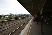
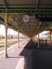
in 1881. Victorian Railways
' North East broad gauge
line was extended from Wodonga
to Albury station in 1883. To accommodate the break of gauge, a very long railway platform was needed; the covered platform is one of the longest in Australia (photograph to the right).
The section between Picton and Mittagong was replaced by a less direct route in 1919 to ease the steep grades of the original alignment, and the old line became known as the Picton- Mittagong loop railway line which is now largely closed. Other sections of the original Great South Line between Goulburn and Wagga Wagga were also replaced by more curvy sections with lower grades in the early 20th century, including a rail spiral at Bethungra
.
Construction of a standard gauge track parallel with the broad gauge track from Albury to Melbourne
was commenced in 1959, completing the Sydney-Melbourne railway. The first freight train operating on the line on January 3, 1962, followed by the first passenger train on April 16 the same year.
 Several lines branched from the Main South, some of which are in-part or fully closed.
network. Self propelled diesel railmotors operate south from Campbelltown to Goulburn
on an irregular frequency as part of the Southern Highlands line service of CityRail.
, a locomotive hauled limited stop passenger train. Operated jointly by the New South Wales Government Railways
and the Victorian Railways
, the Intercapital was the railways' pride and joy. The Spirit of Progress
was the corresponding overnight service between Sydney and Melbourne, and in 1962 this was joined by a new limited stops service, the Southern Aurora
. The Southern Aurora became the premier fast service, and the Spirit of Progress began to serve more intermediate stops.
Until 1982, locomotives were exchanged at Albury for a locomotive of the respective state that the train was entering. The South Mail operated between Sydney and Albury until its replacement in 1984 by the South XPT. In 1985, the Southern Aurora and the Spirit of Progress were merged into the Sydney Express
(or Melbourne depending on the direction). In 1992, airline deregulation and falling patronage saw the Intercapital Daylight replaced by a coach service between Melbourne and Albury, connecting with the South XPT at Albury. In 1993, the delivery of additional XPT rollingstock saw the introduction of a through overnight XPT service between Sydney and Melbourne, replacing the Express, and a through daylight service from 1994. In 2007, passenger service remains a twice daily XPT between Sydney and Melbourne, a daytime and an overnight service.
New South Wales
New South Wales is a state of :Australia, located in the east of the country. It is bordered by Queensland, Victoria and South Australia to the north, south and west respectively. To the east, the state is bordered by the Tasman Sea, which forms part of the Pacific Ocean. New South Wales...
, Australia
Australia
Australia , officially the Commonwealth of Australia, is a country in the Southern Hemisphere comprising the mainland of the Australian continent, the island of Tasmania, and numerous smaller islands in the Indian and Pacific Oceans. It is the world's sixth-largest country by total area...
. It runs through the Southern Highlands
Southern Highlands, New South Wales
The Southern Highlands, also locally referred to as the Highlands, is a geographical region and district in New South Wales, Australia and is 110 km south-west of Sydney. The entire region is under the local government area of the Wingecarribee Shire...
, Southern Tablelands
Southern Tablelands
The Southern Tablelands is a geographic area of the State of New South Wales, Australia. This area is located west of the Great Dividing Range.The area is characterised by flat country which has generally been extensively cleared and used for grazing purposes...
, South West Slopes
South West Slopes, New South Wales
The South West Slopes is a region predominantly in New South Wales, Australia. It covers the lower inland slopes of the Great Dividing Range extending from north of Cowra through southern NSW into western Victoria...
and the Riverina
Riverina
The Riverina is an agricultural region of south-western New South Wales , Australia. The Riverina is distinguished from other Australian regions by the combination of flat plains, warm to hot climate and an ample supply of water for irrigation. This combination has allowed the Riverina to develop...
regions.
Description of route
The Main Southern Railway commences as an electrified pair of tracks in the SydneySydney
Sydney is the most populous city in Australia and the state capital of New South Wales. Sydney is located on Australia's south-east coast of the Tasman Sea. As of June 2010, the greater metropolitan area had an approximate population of 4.6 million people...
metropolitan area. Originally the line branched from the Main Suburban railway line at Granville
Granville, New South Wales
Granville, is a suburb in western Sydney, Australia. Granville is located west of the Sydney central business district, in the local government area of the City of Parramatta. A small part in the north-west is located in the Local Government Area of the City of Holroyd.South Granville is a...
, passing through the suburbs of Fairfield
Fairfield, New South Wales
Fairfield is a western suburb of Sydney, in the state of New South Wales, Australia. Fairfield is located 29 kilometres west of the Sydney central business district and is the administrative centre for the local government area of the City of Fairfield and is also partly in the local government...
and Cabramatta
Cabramatta, New South Wales
Cabramatta is a suburb in south-western Sydney, in the state of New South Wales, Australia. Cabramatta is located 30 kilometres south-west of the Sydney central business district, in the local government area of the City of Fairfield...
to Liverpool
Liverpool, New South Wales
Liverpool is a suburb in south-western Sydney, in the state of New South Wales, Australia. Liverpool is located 32 km south-west of the Sydney central business district, and is the administrative centre of the local government area of the City of Liverpool...
. However this section was later bypassed with a more direct route from Lidcombe via Regents Park to Cabramatta and then on to Liverpool. The former route through Fairfield became known as the Old Main South. From Liverpool, the line heads in a southerly direction to Campbelltown
Campbelltown, New South Wales
Campbelltown is a suburb in south-western Sydney, in the state of New South Wales, Australia. Campbelltown is located 51 kilometres south-west of the Sydney central business district and is the administrative centre for the local government area of the City of Campbelltown.- History :Campbelltown...
and Macarthur
Macarthur, New South Wales
Macarthur is a region in south-west of Sydney, in the state of New South Wales, Australia. The region includes the local government areas of the City of Campbelltown, Camden Council and Wollondilly Shire. It covers an area of 3,067 square kilometres and has a population of close to 240,000 residents...
, the current limit of electrification and electrified passenger services. The line continues as a double non-electrified track south through the Southern Highlands towns of Mittagong
Mittagong, New South Wales
Mittagong is a town located in the Southern Highlands of New South Wales, Australia, in Wingecarribee Shire. At the 2006 census, Mittagong had a population of 7,460 people. The town can be seen as the gateway to the Southern Highlands when coming from Sydney. The town is close to Bowral, Berrima,...
and Goulburn
Goulburn, New South Wales
Goulburn is a provincial city in the Southern Tablelands of New South Wales, Australia in Goulburn Mulwaree Council Local Government Area. It is located south-west of Sydney on the Hume Highway and above sea-level. On Census night 2006, Goulburn had a population of 20,127 people...
to Junee
Junee, New South Wales
Junee is a medium sized town in the Riverina region of New South Wales, Australia. The town's prosperity and mixed services economy is based on a combination of agriculture, rail transport, light industry and government services, and in particular correctional services...
on the Southern Plains. The line is controlled from Junee by the Australian Rail Track Corporation
Australian Rail Track Corporation
Australian Rail Track Corporation is a federal government owned corporation established in 1997 that owns, leases, maintains and controls the majority of main line standard gauge railway lines on the mainland of Australia, known as the Defined Interstate Rail Network .-History:The Interstate...
. Here the line becomes single track for the remainder of its journey south to the state border with Victoria at Albury
Albury, New South Wales
Albury is a major regional city in New South Wales, Australia, located on the Hume Highway on the northern side of the Murray River. It is located wholly within the boundaries of the City of Albury Local Government Area...
. The line then continues through northern Victoria to Melbourne
Melbourne
Melbourne is the capital and most populous city in the state of Victoria, and the second most populous city in Australia. The Melbourne City Centre is the hub of the greater metropolitan area and the Census statistical division—of which "Melbourne" is the common name. As of June 2009, the greater...
.
Development of the line
In 26 September 1855 the first railway in New South Wales, the Sydney–Granville railway opened. Exactly a year later, a branch was opened from what was known as Parramatta Junction (the present day Granville) to Liverpool. This line was extended to Campbelltown in 1858, Picton in 1863, Mittagong in 1867, Marulan in 1868, Goulburn in 1869, YassYass, New South Wales
Yass is a town in the Southern Tablelands of New South Wales, Australia in Yass Valley Shire. The name appears to have been derived from an Aboriginal word, "Yarrh" , said to mean 'running water'....
Junction in 1876, Galong
Galong, New South Wales
Galong is a small town in New South Wales, Australia located in Harden Shire. At the 2006 census, Galong had a population of 122 people.The town is well known for its cemetery, which has among other monuments, some angels carved by Frank Rusconi, the monumental mason from Gundagai.St Clement's...
, Harden-Murrumburrah
Harden, New South Wales
Harden-Murrumburrah is a township and community in the centre of Harden Shire and is located in the South West Slopes region of New South Wales in Australia and is adjacent to both the Canberra region of the Australian Capital Territory and the Riverina Region in the southwest area of NSW...
and Cootamundra
Cootamundra, New South Wales
Cootamundra is a town and Local Government Area in the South West Slopes region of New South Wales, Australia and within the Riverina. At the 2006 census, Cootamundra had a population of 5,566. It is located on the Olympic Highway at the point where it crosses the Muttama Creek, between Junee and...
in 1877 and Junee
Junee, New South Wales
Junee is a medium sized town in the Riverina region of New South Wales, Australia. The town's prosperity and mixed services economy is based on a combination of agriculture, rail transport, light industry and government services, and in particular correctional services...
and Bomen
Bomen, New South Wales
Bomen is a northern suburb of Wagga Wagga in southern New South Wales, Australia. The suburb is dominated by industrial enterprises including Cargill Beef, Watties, the Wagga Wagga Livestock Marketing Centre...
(on the north bank of the Murrumbidgee River
Murrumbidgee River
The Murrumbidgee River is a major river in the state of New South Wales, Australia, and the Australian Capital Territory . A major tributary of the Murray River, the Murrumbidgee flows in a west-northwesterly direction from the foot of Peppercorn Hill in the Fiery Range of the Snowy Mountains,...
) in 1878. The Murrumbidgee River Rail Bridge
Murrumbidgee River Rail Bridge (Wagga Wagga)
Murrumbidgee River Rail Bridge is located over the Murrumbidgee River in Wagga Wagga, New South Wales. The bridge was the only 4 span wrought iron lattice truss bridge constructed and is the second oldest bridge out of the twelve related wrought iron lattice truss series bridges in Australia...
was completed in 1881 and the line was extended to Wagga Wagga
Wagga Wagga, New South Wales
Wagga Wagga is a city in New South Wales, Australia. Straddling the Murrumbidgee River, and with an urban population of 46,735 people, Wagga Wagga is the state's largest inland city, as well as an important agricultural, military, and transport hub of Australia...
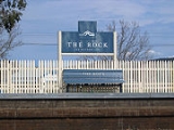
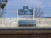
, Uranquinty, The Rock
The Rock, New South Wales
The Rock is a town, with a population of 860, in the Riverina region of southern New South Wales, Australia, in Lockhart Shire and the City of Wagga Wagga. It is situated 32km south west of Wagga Wagga on the Olympic Highway....
, Henty
Henty, New South Wales
Henty is a town on the Olympic Highway almost midway between Albury and Wagga Wagga in New South Wales, Australia. Henty is situated on the border of the South West Slopes and the Riverina districts. At the 2006 census, Henty had a population of 863 people....
and Albury
Albury, New South Wales
Albury is a major regional city in New South Wales, Australia, located on the Hume Highway on the northern side of the Murray River. It is located wholly within the boundaries of the City of Albury Local Government Area...
in 1881. Victorian Railways
Victorian Railways
The Victorian Railways operated railways in the Australian state of Victoria from 1859 to 1983. The first railways in Victoria were private companies, but when these companies failed or defaulted, the Victorian Railways was established to take over their operations...
' North East broad gauge
Victorian broad gauge
Rail gauge in Australia displays significant variation, which has been an ongoing problem for transportation on the Australian continent, for over a hundred years.-Track gauges and route km:The most used gauges are Main gauges:...
line was extended from Wodonga
Wodonga, Victoria
Wodonga is a small city on the Victorian side of the border with New South Wales, north-east of Melbourne, Australia. Adjacent to Wodonga across the border is the New South Wales city of Albury. Wodonga is located wholly within the boundaries of the City of Wodonga LGA...
to Albury station in 1883. To accommodate the break of gauge, a very long railway platform was needed; the covered platform is one of the longest in Australia (photograph to the right).
The section between Picton and Mittagong was replaced by a less direct route in 1919 to ease the steep grades of the original alignment, and the old line became known as the Picton- Mittagong loop railway line which is now largely closed. Other sections of the original Great South Line between Goulburn and Wagga Wagga were also replaced by more curvy sections with lower grades in the early 20th century, including a rail spiral at Bethungra
Bethungra Spiral (railway)
The Bethungra Spiral is a rail spiral, built on the Main South railway line of New South Wales in Australia at Bethungra to ease the gradients when the line was duplicated between 1941 and 1946...
.
Construction of a standard gauge track parallel with the broad gauge track from Albury to Melbourne
Melbourne
Melbourne is the capital and most populous city in the state of Victoria, and the second most populous city in Australia. The Melbourne City Centre is the hub of the greater metropolitan area and the Census statistical division—of which "Melbourne" is the common name. As of June 2009, the greater...
was commenced in 1959, completing the Sydney-Melbourne railway. The first freight train operating on the line on January 3, 1962, followed by the first passenger train on April 16 the same year.
Branches
- The Bombala Line was opened from Goulburn to BungendoreBungendore, New South WalesBungendore is a town in the Southern Tablelands of New South Wales, Australia, in Palerang Council. It is on the Kings Highway near Lake George, the Molonglo River Valley and the Australian Capital Territory border. It has become a major tourist centre in recent years, popular with visitors from...
in 1885, QueanbeyanQueanbeyan, New South WalesQueanbeyan is a regional centre in the Southern Tablelands in south-eastern New South Wales adjacent to the Australian Capital Territory. The city's mixed economy is based on light construction, high technology, manufacturing, service, retail and agriculture. It is the council seat of the...
in 1887, CoomaCooma, New South Wales-Education: is Cooma's only public high school, it serves the town and seven of the neighbouring rural towns and villages such as Berridale, Jindabyne, Nimmitabel, Bredbo and Dalgety....
in 1889, NimmitabelNimmitabel, New South WalesNimmitabel is a small town in the Monaro region in southeast New South Wales, Australia, in the Cooma-Monaro Shire Local government area. At the 2006 census, Nimmitabel had a population of 237 people....
in 1912 and BombalaBombala, New South WalesBombala is a town in the Monaro region of south-eastern New South Wales, Australia, in Bombala Council. It is located approximately south of the state capital, Sydney, and south of the town of Cooma. The name derives from an Aboriginal word meaning "Meeting of the waters". The town lies on the...
in 1921. This line south of Queanbeyan served largely pastoral country and therefore it did not have any major freight traffic and it was closed in 1986.
- The Canberra BranchCanberra railway stationCanberra railway station is located in Kingston, Australian Capital Territory. The station is the terminus for CountryLink rail services from Sydney...
, an 8 km branch line from Queanbeyan to CanberraCanberraCanberra is the capital city of Australia. With a population of over 345,000, it is Australia's largest inland city and the eighth-largest city overall. The city is located at the northern end of the Australian Capital Territory , south-west of Sydney, and north-east of Melbourne...
, was opened in 1914. A 34 km branch line from Bungendore to Captains FlatCaptains Flat, New South WalesCaptains Flat is a town in the Southern Tablelands of New South Wales, Australia, in Palerang Shire. It is south of Queanbeyan.It is suggested that a bullock named "Captain" from Foxlow station, 12 km away, grazed here and hence the place name....
was opened in 1940 and closed in 1969, a few years after the closure of the local mines.
- The Crookwell Line opened from Goulburn to CrookwellCrookwell, New South WalesCrookwell is a small town located in the Southern Tablelands of New South Wales, Australia, in the Upper Lachlan Shire. At the 2006 census, Crookwell had a population of 1,993 people. The town is at a relatively high altitude in Australian terms , and there are occasional snowfalls during the...
in 1902; it closed in 1985. A branch line was opened off it from a junction at Roslyn to TaralgaTaralga, New South WalesTaralga is a small village in the Southern Tablelands of New South Wales, Australia in Upper Lachlan Shire. It is located at the intersection of the Goulburn-Oberon Road and the Laggan-Taralga Road. It is accessible from Oberon to the north, Mittagong to the east, Goulburn to the south, and...
in 1926; it closed in 1957.
- The Yass Branch, a 5 km-long line between Yass Junction and YassYass, New South WalesYass is a town in the Southern Tablelands of New South Wales, Australia in Yass Valley Shire. The name appears to have been derived from an Aboriginal word, "Yarrh" , said to mean 'running water'....
, opened in 1892 and it closed about 1958.
- The Burrinjuck Tramway was a 610mm gauge line was built in about 1907 from Goondah (between Bowning and BinalongBinalong, New South WalesBinalong is a village in the Southern Tablelands of New South Wales, Australia, 37 km north-west of Yass in Yass Valley Shire. In 2006, the town had a population of about 269 people.- Overview :...
) to Burrinjuck for the construction of the Burrinjuck DamBurrinjuck DamBurrinjuck Dam is a high, concrete gravity dam on the Murrumbidgee River approximately 60 km from Yass, New South Wales, Australia. The Yass and Goodradigbee Rivers flow into the dam. The dam divides the upper and lower catchment of the Murrumbidgee and is the headwater storage for the...
and closed in 1929, following the completion of construction.
- The Boorowa branch line was opened from Galong to BoorowaBoorowa, New South WalesBoorowa is a farming town in the South West Slopes of New South Wales, Australia. At the 2006 census, Boorowa had a population of 1,070 people. It is located in a valley 243 km west of Sydney and 487 m above sea-level...
in 1915 and closed in 1987.
- The Demondrille to Blayney branch opened between Demondrille (14 km "south" of Harden) and YoungYoung, New South Wales-Demographics:On census night, 7 August 2001, there were 6,821 people counted in Young. There were 238 people who identified as being of Indigenous origin in the 2001 Census...
in 1885, and extended to CowraCowra, New South WalesCowra is a town in the Central West region of New South Wales, Australia in the Cowra Shire. It is located on the Mid-Western Highway, 317 kilometres west of Sydney on the banks of the Lachlan River at an altitude of 310 metres above sea level. At the 2006 census Cowra had a population of 8,430...
in 1886 and BlayneyBlayney, New South WalesBlayney is a farming town and administrative centre with a population of 2,745 in 2006, in the Central West region of New South Wales, Australia...
on the Main Western Line in 1888.
- The Grenfell branch was built from Koorawatha Junction (31 km south of Cowra) to GrenfellGrenfell, New South WalesGrenfell is a country town in the Central West of New South Wales, Australia, in Weddin Shire. It is 370 kilometres west of Sydney and five hours' drive from the city. It is close to Forbes, Cowra and Young. At the 2006 census, Grenfell had a population of 1,994.-History:Prior to European...
in 1901. This line is now closed beyond Greenthorpe. A branch was built from Cowra to CanowindraCanowindra, New South WalesCanowindra is an historic township located near Cowra in the central west of New South Wales, Australia in Cabonne Shire. Canowindra is on the Belubula River. The curving main street, Gaskill Street, is partly an urban conservation area. At the 2006 census, Canowindra had a population of 1,499...
in 1910 and Eugowra in 1922, but is now closed.
- The Lake Cargelligo line opened from CootamundraCootamundra, New South WalesCootamundra is a town and Local Government Area in the South West Slopes region of New South Wales, Australia and within the Riverina. At the 2006 census, Cootamundra had a population of 5,566. It is located on the Olympic Highway at the point where it crosses the Muttama Creek, between Junee and...
to StockinbingalStockinbingal, New South WalesStockinbingal is a village in Cootamundra Shire in the South West Slopes region of New South Wales, Australia. It is also a part of the Riverina, and is on the Burley Griffin Way...
and TemoraTemora, New South WalesTemora is a town located in north east part of the Riverina area of New South Wales, south-west of the state capital, Sydney. At the 2006 census the population of Temora was 4,086.-History:...
in 1893, Barmedan and WyalongWyalong, New South WalesWyalong is part of the Bland Shire located in the Northern Riverina Region of New South Wales, Australia. Established as a gold mining town, it is now a quiet town with historic buildings a few kilometres east of West Wyalong, the major district service centre...
in 1903, and West WyalongWest Wyalong, New South WalesWest Wyalong is a town in New South Wales, Australia which is the main town of the Bland Shire, located in the Central West region of New South Wales. It is located 467 km west of Sydney. It is located on the crossroads of the Newell Highway between Melbourne and Brisbane, and the Mid-Western...
, UngarieUngarie, New South WalesUngarie is a town in New South Wales, Australia which is the second major town of the Bland Shire, located in the Central West region of New South Wales. It is located west of Sydney and north of Melbourne, between the towns of West Wyalong and Lake Cargelligo and is situated above sea level...
and Lake CargelligoLake Cargelligo, New South WalesLake Cargelligo is a town in the Central West region of New South Wales, Australia, on Lake Cargelligo. It is in Lachlan Shire. At the 2006 census, Lake Cargelligo had a population of 1,146 people. Its name is said to be a corruption of the Aboriginal word 'Kartjellakoo' meaning 'he had a...
in 1917.
- The Stockinbingal to Parkes line was completed from Stockinbingal to Caragabal in 1916 and ForbesForbes, New South Wales-Notable residents:*Carolyn Simpson - Judge of the Supreme Court of New South Wales; Member of the first all-female bench to sit in an Australian court*NSW Deputy Premier Carmel Tebbutt was born and raised in Forbes....
in 1918, which is now part of the main route for freight trains between SydneySydneySydney is the most populous city in Australia and the state capital of New South Wales. Sydney is located on Australia's south-east coast of the Tasman Sea. As of June 2010, the greater metropolitan area had an approximate population of 4.6 million people...
and PerthPerth, Western AustraliaPerth is the capital and largest city of the Australian state of Western Australia and the fourth most populous city in Australia. The Perth metropolitan area has an estimated population of almost 1,700,000....
.
- The Temora to Roto line was completed from Temora to BarellanBarellan, New South WalesBarellan is a small village in Narrandera Shire in the Riverina region of New South Wales, Australia. On Census night 2006, Barellan had a population of 366 people...
in 1908, GriffithGriffith, New South WalesGriffith is a city in south-western New South Wales, Australia. It is also the seat of the City of Griffith local government area. Like the Australian capital, Canberra and the nearby town of Leeton, Griffith was designed by Walter Burley Griffin. Griffith was named after Sir Arthur Griffith the...
in 1916, HillstonHillston, New South WalesHillston is a township in western New South Wales, Australia, in Carrathool Shire, built on the banks of the Lachlan River. It was founded in 1863 and at the 2006 census had a population of 1,054.-History:...
in 1923 and the Broken Hill line at Roto in 1931. The line between Hillston and Roto was closed in 1986.
- The Rankins Springs branch was completed between Barmedan to Rankins SpringsRankins Springs, New South WalesRankins Springs is a small town in the Riverina region of New South Wales, Australia. It is in Carrathool Shire Council and on the Mid-Western Highway...
in 1923.
- The Tumut line was completed from Cootamundra to GundagaiGundagai, New South WalesGundagai is a town in New South Wales, Australia. Although a small town, Gundagai is a popular topic for writers and has become a representative icon of a typical Australian country town...
in 1886 and extended to TumutTumut, New South WalesTumut is a town in the Riverina region of New South Wales, Australia, situated on the banks of the Tumut River. Tumut is at the foothills of the Snowy Mountains and is referred to as the gateway to the Snowy Mountains Scheme...
in 1903, and a branch from it was built to Batlow and Kunama in 1923. The line past Batlow was closed 1957 and the rest were closed after flood damage in 1984.
- The Hay line was completed from JuneeJunee, New South WalesJunee is a medium sized town in the Riverina region of New South Wales, Australia. The town's prosperity and mixed services economy is based on a combination of agriculture, rail transport, light industry and government services, and in particular correctional services...
to NarranderaNarrandera, New South Wales-Transport:Narrandera is well served for transport. The Sturt Highway and the Newell Highways cross, just south of Narrandera. Greyhound buses pass daily - note that the destination can be listed as Jillenbah....
, YancoYanco, New South WalesYanco is a village with a population of 572 in Leeton Shire in South Western New South Wales, Australia. Yanco is a Wiradjuri aboriginal language word meaning the sound of running water. Yanco is located three kilometres from Leeton along the Irrigation Way...
and Wilbriggie in 1881 and HayHay, New South WalesHay is a town in the western Riverina region of south western New South Wales , Australia. It is the administrative centre of Hay Shire Local Government Area and the centre of a prosperous and productive agricultural district on the wide Hay Plains....
in 1882. The line west of Wilbriggie was closed in 1985.
- The Tocumwal lineTocumwal railway line, New South WalesThe Tocumwal railway line is a closed railway line in New South Wales, Australia. The line branched from the still open Junee - Hay line at Narrandera station and then headed south west to Tocumwal station where there was a break-of-gauge with the Victorian Railways Goulburn Valley line from...
was completed from Narrandera to JerilderieJerilderie, New South WalesJerilderie is a town of 768 people in the southern Riverina region of New South Wales, Australia. It is the only town in the Jerilderie Shire Local Government Area....
in 1884 and FinleyFinley, New South WalesFinley is a town in the Riverina region of New South Wales, Australia. It is the largest town in the Berrigan Shire Local Government Area. At the 2006 census, Finley had a population of 2,054 people....
and TocumwalTocumwal, New South WalesTocumwal is a town in the southern Riverina region of New South Wales, Australia in the Berrigan Shire Local Government Area, near the Victorian border. The town is situated on the banks of the Murray River, north of the city of Melbourne. The Newell Highway, part of the main road route between...
in 1898. The Victorian RailwaysVictorian RailwaysThe Victorian Railways operated railways in the Australian state of Victoria from 1859 to 1983. The first railways in Victoria were private companies, but when these companies failed or defaulted, the Victorian Railways was established to take over their operations...
were extended to Tocumwal in 1908, creating a break-of-gaugeBreak-of-gaugeWith railways, a break-of-gauge occurs where a line of one gauge meets a line of a different gauge. Trains and rolling stock cannot run through without some form of conversion between gauges, and freight and passengers must otherwise be transloaded...
. The branch from Narrandera to Tocumwal is now closed, although proposed for reopening as part of a standard gauge inland route between Mangalore, VictoriaMangalore, VictoriaMangalore is a town in the state of Victoria, Australia.It was serviced by the Mangalore Railway Station, and is currently serviced by the Mangalore Airport. It is 2 hours north of Melbourne. It is accessible by road along the Goulburn Valley Highway and Hume Highway.-References:...
; Parkes, New South WalesParkes, New South Wales- Transport :Parkes has a local bus service provided by Western Road Liners, which acquired Harris Bus Lines in March 2006. The Indian Pacific also stops twice a week, as well as the Broken Hill Outback Xplorer service, run by CountryLink, which heads to Broken Hill on Mondays and Sydney on...
; Toowoomba, QueenslandToowoomba, QueenslandToowoomba is a city in Southern Queensland, Australia. It is located west of Queensland's capital city, Brisbane. With an estimated district population of 128,600, Toowoomba is Australia's second largest inland city and its largest non-capital inland city...
and BrisbaneBrisbaneBrisbane is the capital and most populous city in the Australian state of Queensland and the third most populous city in Australia. Brisbane's metropolitan area has a population of over 2 million, and the South East Queensland urban conurbation, centred around Brisbane, encompasses a population of...
.
- The Yanco- Griffith connection was completed between Yanco and Griffith on the line between Cootamundra, Hillston and Roto in 1922. This line is still used by passenger trains once a week.
- The Tumbarumba branch line was completed from Wagga Wagga to TarcuttaTarcutta, New South WalesTarcutta is a small town located 438 km south-west of Sydney, three kilometres east of the Hume Highway, in New South Wales, Australia. It was proclaimed as a village on 28 October 1890...
in 1917 and TumbarumbaTumbarumba, New South WalesTumbarumba is a small town in New South Wales, Australia, about 500 km southwest of Sydney. Tumbarumba is located within the Riverina region and more specifically on the South West Slopes at the western edge of the Snowy Mountains. At the 2006 Census of Population and Housing, people lived...
in 1921. It climbed the foothills of the Australian AlpsAustralian AlpsThe Australian Alps are the highest mountain ranges of mainland Australia. They are located in southeastern Australia and straddle the Australian Capital Territory, south-eastern New South Wales and eastern Victoria...
, but was expensive to maintain and did not have the grain traffic that supported the westerly branches. This was closed in 1974.
- The Kywong branch opened from Uranquinty to Kywong in 1929 and closed in 1975.
- The Oaklands lineOaklands railway line, New South WalesThe Oaklands railway line is a partly closed railway line in New South Wales, Australia. It is a branch of the Main South line at The Rock, and heads in a southwesterly direction through the towns of Boree Creek and Urana to Oaklands. The line opened in 1901 to Lockhart, and in 1912 to Oaklands....
opened from The RockThe Rock, New South WalesThe Rock is a town, with a population of 860, in the Riverina region of southern New South Wales, Australia, in Lockhart Shire and the City of Wagga Wagga. It is situated 32km south west of Wagga Wagga on the Olympic Highway....
to LockhartLockhart, New South WalesLockhart is a town and a Local Government Area in the Riverina Region of New South Wales, Australia. It is the location of the Lockhart Shire Council offices. At the 2006 census, Lockhart had a population of 837 people.-History:...
in 1901 and OaklandsOaklands, New South WalesOaklands is a town in the Riverina district of southern New South Wales, Australia. The town is located 615 kilometres south west of the state capital, Sydney and 105 kilometres north west of Albury. Oaklands is in the Urana Shire Local government area and at the 2006 census, had a population of...
in 1912. The Victorian RailwaysVictorian RailwaysThe Victorian Railways operated railways in the Australian state of Victoria from 1859 to 1983. The first railways in Victoria were private companies, but when these companies failed or defaulted, the Victorian Railways was established to take over their operations...
1600mm gauge line was extended to Oaklands in 1938, creating a break-of-gaugeBreak-of-gaugeWith railways, a break-of-gauge occurs where a line of one gauge meets a line of a different gauge. Trains and rolling stock cannot run through without some form of conversion between gauges, and freight and passengers must otherwise be transloaded...
. The line has been closed beyond Boree CreekBoree Creek, New South WalesBoree Creek is a town in the Riverina district of New South Wales, Australia. The town is located south west of the state capital, Sydney and west of the regional centre, Wagga Wagga. Boree Creek is situated in the Urana Shire Local Government Area but is closer to the town of Lockhart...
.
- The Westby branch opened from The RockThe Rock, New South WalesThe Rock is a town, with a population of 860, in the Riverina region of southern New South Wales, Australia, in Lockhart Shire and the City of Wagga Wagga. It is situated 32km south west of Wagga Wagga on the Olympic Highway....
to Westby in 1925 and closed in 1952 and 1956.
- The Rand branch opened from HentyHenty, New South WalesHenty is a town on the Olympic Highway almost midway between Albury and Wagga Wagga in New South Wales, Australia. Henty is situated on the border of the South West Slopes and the Riverina districts. At the 2006 census, Henty had a population of 863 people....
to RandRand, New South WalesRand is a town in the Riverina district of New South Wales, Australia. It is located in the Urana Shire Local Government Area. At the 2006 census, Rand had a population of 210....
in 1920.
- The Corowa branch opened from CulcairnCulcairn, New South WalesCulcairn is a town in the south east Riverina region of New South Wales, Australia. Culcairn is located in the Greater Hume Shire Council Local government area on the Olympic Highway between Albury and Wagga Wagga...
to CorowaCorowa, New South WalesCorowa is a town in the state of New South Wales in Australia. It is on the bank of the Murray River, the border between New South Wales and Victoria, opposite the Victorian town of Wahgunyah. Corowa is the administrative centre of Corowa Shire...
in 1892 and closed in the 1990s.
- The Holbrook branch was a short line which opened from Culcairn to HolbrookHolbrook, New South WalesHolbrook is a small town in Southern New South Wales, Australia. It is on the Hume Highway, 356 km North-East of Melbourne and 491 km south-west of Sydney between Tarcutta and Albury. The town is in the Greater Hume Shire Council area which was established in May 2004 from the merger of...
in 1902 and closed in the 1980s.
Passenger services
Commuter services
Electric commuter passenger trains operate from Sydney between Lidcombe and Macarthur as part of the CityRailCityRail
CityRail is an operating brand of RailCorp, a corporation owned by the state government of New South Wales, Australia. It is responsible for providing commuter rail services, and some coach services, in and around Sydney, Newcastle and Wollongong, the three largest cities of New South Wales. It is...
network. Self propelled diesel railmotors operate south from Campbelltown to Goulburn
Goulburn, New South Wales
Goulburn is a provincial city in the Southern Tablelands of New South Wales, Australia in Goulburn Mulwaree Council Local Government Area. It is located south-west of Sydney on the Hume Highway and above sea-level. On Census night 2006, Goulburn had a population of 20,127 people...
on an irregular frequency as part of the Southern Highlands line service of CityRail.
Country services
Prior to 1962, travelling south of Albury into Victoria required a change of trains (due to gauge differences between NSW and Victoria) and often an overnight stay. From 1956, a daylight connection was introduced between Sydney and Melbourne whereby a train from Sydney connected at Albury with a train to Melbourne and vice versa. In 1962, the railway south of Albury became standardised, and this allowed through operation of trains between Sydney and Melbourne. Between 1962 and 1991, the Main South was served by the Intercapital DaylightIntercapital Daylight
The Intercapital Daylight was a named passenger train that operated between the cities of Melbourne and Sydney in Australia, running during the daytime making intermediate stops between Sydney and Albury, but running express between Albury and Melbourne.-History:On the Victorian side the train was...
, a locomotive hauled limited stop passenger train. Operated jointly by the New South Wales Government Railways
New South Wales Government Railways
The New South Wales Government Railways was the government department that operated the New South Wales Government's railways until the establishment of the Public Transport Commission in 1972. Although later known officially as the Department of Railways, New South Wales, it was still generally...
and the Victorian Railways
Victorian Railways
The Victorian Railways operated railways in the Australian state of Victoria from 1859 to 1983. The first railways in Victoria were private companies, but when these companies failed or defaulted, the Victorian Railways was established to take over their operations...
, the Intercapital was the railways' pride and joy. The Spirit of Progress
Spirit of Progress
The Spirit of Progress was the premier express train passenger service on the Victorian Railways in Australia, running from Melbourne to the Victorian border, and later through to Sydney.-Route:...
was the corresponding overnight service between Sydney and Melbourne, and in 1962 this was joined by a new limited stops service, the Southern Aurora
Southern Aurora
The Southern Aurora was a named express passenger train that operated between the cities of Melbourne, Victoria, and Sydney, New South Wales, in Australia. First-class throughout, including the dining facilities, the Southern Aurora featured all-sleeper accommodation...
. The Southern Aurora became the premier fast service, and the Spirit of Progress began to serve more intermediate stops.
Until 1982, locomotives were exchanged at Albury for a locomotive of the respective state that the train was entering. The South Mail operated between Sydney and Albury until its replacement in 1984 by the South XPT. In 1985, the Southern Aurora and the Spirit of Progress were merged into the Sydney Express
Sydney/Melbourne Express
The Sydney/Melbourne Express was an intercapital passenger train service that operated between the Australian cities of Melbourne and Sydney between 1986 and 1993...
(or Melbourne depending on the direction). In 1992, airline deregulation and falling patronage saw the Intercapital Daylight replaced by a coach service between Melbourne and Albury, connecting with the South XPT at Albury. In 1993, the delivery of additional XPT rollingstock saw the introduction of a through overnight XPT service between Sydney and Melbourne, replacing the Express, and a through daylight service from 1994. In 2007, passenger service remains a twice daily XPT between Sydney and Melbourne, a daytime and an overnight service.
See also
- Rail transport in New South WalesRail transport in New South WalesThe Australian state of New South Wales has an extensive network of railways, which were integral to the growth and development of the state. The vast majority of railway lines were government built and operated, but there were also several private railways, some of which operate to this...
- Railways in SydneyRailways in SydneySydney, the largest city in Australia, has an extensive network of passenger and freight railways. The passenger network is a hybrid metro-suburban railway with a central underground core running at metro style frequencies, which branches out into a suburban commuter type network...
- CityRail's South lineSouth railway line, SydneyThe South Line is a railway line in Sydney, New South Wales, Australia, and is part of the CityRail suburban network...
- CityRail's Southern Highlands line