
Margerie Glacier
Encyclopedia
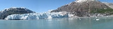
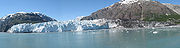
Margerie Glacier is a 21-mile-long (34 km) tide water glacier
in Glacier Bay
in Alaska
and is part of the Glacier Bay National Park and Preserve
. It begins on the south slope of Mount Root, at the Alaska
-Canada
border in the Fairweather Range
, and flows southeast and northeast to Tarr Inlet. It was named for the famed French geographer and geologist Emmanuel de Margerie
(1862–1953), who visited the Glacier Bay in 1913. It is an integral part of the Glacier Bay, which was declared a National Monument on February 26, 1925, a National Park and Wild Life Preserve on December 2, 1980, a UNESCO declared World Biosphere Reserve in 1986 and a World Heritage Site
in 1992. While most of the tidewater and terrestrial glaciers in the Park
are stated to be thinning and receding over the last several decades, Margerie Glacier is said to be stable and Johns Hopkins Glacier
is stated to be advancing, on the eastern face of the Fairweather Range.
Marjerie Glacier at Mile 63 is perpendicular to the Grand Pacific Glacier
at Mile 64 (widest glacier in the Glacier bay with width of about 2 miles (3.2 km)). It flows in southeast and northeast direction to Tarr Inlet, one mile (1.6 km) north of the terminus of Grand Pacific Glacier and 87 miles (140 km) northwest of Hoonah
. Glacier Bay provides excellent glacier experiences of both receding and advancing glaciers existing side by side. Tarr Inlet forms the northwestern part of the Glacier Bay named in 1912 for professor of geology Dr Ralph Tarr. The Glacier Bay region, which in 1750 was a mass of ice of a single glacier, has undergone a dynamic change and is now a 65-mile long fjord
.
Glacier Bay and the Marjorie Glacier are approachable only by air and water. The steep dropoff of the Margerie Glacier cliff facilitates large cruise ships to park close to the glacier from where one gets incredible views of the glacier.
In a study of the bed rock geology and mineral resources of the Glacial Bay, out of 17 areas classified as containing mineral deposits, Marjerie Glacier has been identified as containing copper deposits.
 History of the Marjerie Glacier is integral to the history of Glacier Bay. In 1791, Glacier Bay was a wall of ice when Captain Vancouver was blocked in his explorations by a wall of 2 miles (3.2 km) width and 4000 feet (1,219.2 m) thick. 88 years later, when in 1888 John Muir
had first visited the bay, this wall was 48 miles and had retreated by 44 miles (70.8 km). Now, it has retreated to 65 miles as a remnant of the old wall of the glacier system and has 16 major tidewater glaciers (10 and 12 were also mentioned in some references). Margerie Glacier is at Mile 63 of this system and named after French Geologist Emmanuel de Margerie who visited the area in 1913. The Great Pacific Glacier is at Mile 65 from the mouth of the Glacial Bay.
). The glacier exhibits a distinctive curved layer of rock debris mixed with ice. The glacier has impressive configurations (as if carved with hand tools), in a "jagged and twisted form", set in ice which is seen in blue color as a result of absorption of rays of shorter red and green wavelengths. It is a much cleaner glacier as compared to other glaciers in the Glacier Bay. It is also one of the most active glacier for "Calving" (a word meaning breaking and dropping of ice walls into the sea). As the glacier calves, "a rifle-like crack and a booming roar is heard creating a boiling like turbulence."
Some times, ice caves get formed in the glacier, which is considered highly unstable since blocks of ice collapse into the water from the sides of the cave formation and create a resounding noise as it splashes.
The glaciers in the Glacier Bay are stated to be remnants of a general "ice advance – the Little Ice Age – that began about 4,000 years ago". This advance is not comparable to continental glaciation that occurred during "Pleistocene times known as the Wisconsin Ice Age". However, about 1750, the 'Little Ice Age' reached its maximum stage and then melting started. Ice flows have been recorded at Marjorie Glacier 2000 feet (609.6 m) per year or 6 feet (1.8 m) per day. Its advance was reported to be at the rate of 30 feet (9.1 m) per year till 1998 when some degree of recession has been noticed at its northern terminus "forming a small embayment," while the southern part is advancing at 1 foot (0.3048 m) per year. In the 1990s, the glacier was attached to the Grand Pacific Glacier. However, it is now detached from the Grand Pacific (which is said to be receding) and moranic material is seen where it has separated on its northern extremity, discerned by a small stream. As result, the Margerie Glacier is termed "a hanging glacier with its base about 600 feet (182.9 m) above the floor of Tarr Inlet near its center." Fresh water 'upswellings' are seen to emerge from the central area of the glacier, generated by the melt water discharges of sub glacial streams; such areas are swarmed by sea birds for feeding on fish.
and small fish, thus making it an ideal spot for birds. Whales and bears are also seen around this glacier.
Glacier
A glacier is a large persistent body of ice that forms where the accumulation of snow exceeds its ablation over many years, often centuries. At least 0.1 km² in area and 50 m thick, but often much larger, a glacier slowly deforms and flows due to stresses induced by its weight...
in Glacier Bay
Glacier Bay
Glacier Bay Basin in southeastern Alaska, United States, encompasses the Glacier Bay and surrounding mountains and glaciers, which was first proclaimed a U.S. National Monument on February 25, 1925 and which was later, on Dec...
in Alaska
Alaska
Alaska is the largest state in the United States by area. It is situated in the northwest extremity of the North American continent, with Canada to the east, the Arctic Ocean to the north, and the Pacific Ocean to the west and south, with Russia further west across the Bering Strait...
and is part of the Glacier Bay National Park and Preserve
Glacier Bay National Park and Preserve
Glacier Bay National Park is a national park in Alaska. The area around Glacier Bay in southeastern Alaska was first proclaimed a U.S. National Monument on February 25, 1925. It was changed to Glacier Bay National Park and Preserve on Dec. 2, 1980 by the Alaska National Interest Lands Conservation...
. It begins on the south slope of Mount Root, at the Alaska
Alaska
Alaska is the largest state in the United States by area. It is situated in the northwest extremity of the North American continent, with Canada to the east, the Arctic Ocean to the north, and the Pacific Ocean to the west and south, with Russia further west across the Bering Strait...
-Canada
Canada
Canada is a North American country consisting of ten provinces and three territories. Located in the northern part of the continent, it extends from the Atlantic Ocean in the east to the Pacific Ocean in the west, and northward into the Arctic Ocean...
border in the Fairweather Range
Fairweather Range
The Fairweather Range is the unofficial name for a mountain range located in the U.S. state of Alaska and the Canadian province of British Columbia. It is the southernmost range of the Saint Elias Mountains...
, and flows southeast and northeast to Tarr Inlet. It was named for the famed French geographer and geologist Emmanuel de Margerie
Emmanuel de Margerie
Emmanuel Marie Pierre Martin Jacquin de Margerie ForMemRS was a French geographer after whom the Margerie Glacier was named, which he visited in 1913. He was awarded the Cullum Geographical Medal of the American Geographical Society in 1919. In 1923 de Margerie was awarded the Mary Clark Thompson...
(1862–1953), who visited the Glacier Bay in 1913. It is an integral part of the Glacier Bay, which was declared a National Monument on February 26, 1925, a National Park and Wild Life Preserve on December 2, 1980, a UNESCO declared World Biosphere Reserve in 1986 and a World Heritage Site
World Heritage Site
A UNESCO World Heritage Site is a place that is listed by the UNESCO as of special cultural or physical significance...
in 1992. While most of the tidewater and terrestrial glaciers in the Park
Glacier Bay National Park and Preserve
Glacier Bay National Park is a national park in Alaska. The area around Glacier Bay in southeastern Alaska was first proclaimed a U.S. National Monument on February 25, 1925. It was changed to Glacier Bay National Park and Preserve on Dec. 2, 1980 by the Alaska National Interest Lands Conservation...
are stated to be thinning and receding over the last several decades, Margerie Glacier is said to be stable and Johns Hopkins Glacier
Johns Hopkins Glacier
Johns Hopkins Glacier is a long glacier located in Glacier Bay National Park and Preserve in the U.S. state of Alaska. It begins on the east slopes of Lituya Mountain and Mount Salisbury, and trends east to the head of Johns Hopkins Inlet, southwest of the terminus of Clark Glacier and northwest...
is stated to be advancing, on the eastern face of the Fairweather Range.
Topography
Located at the deep end of the Glacier Bay, Margerie Glacier extends over a width of about 1 miles (1.6 km) and extends upstream for a length of 21 miles (33.8 km) till its source on the southern slopes of the hill of Mount Root, at the Alaska-Canada border. Mount Root (elevation 12860 feet (3,919.7 m)), named Boundary Peak 165, is a mountain in Alaska and British Columbia, is part of the Fairweather Range (Mt. Fairweather is the tallest peak with elevation of15325 feet (4,671.1 m)) of the Saint Elias Mountains. It is named after Elihu Root, who was among the diplomats involved in settling the Alaska boundary dispute between the United States and Canada. The Margerie Glacier starts from this range of mountains from Mount Root.Marjerie Glacier at Mile 63 is perpendicular to the Grand Pacific Glacier
Grand Pacific Glacier
Grand Pacific Glacier is a 25-mile long glacier in British Columbia and Alaska. It begins in Glacier Bay National Park in the St...
at Mile 64 (widest glacier in the Glacier bay with width of about 2 miles (3.2 km)). It flows in southeast and northeast direction to Tarr Inlet, one mile (1.6 km) north of the terminus of Grand Pacific Glacier and 87 miles (140 km) northwest of Hoonah
Hoonah, Alaska
Hoonah is a Tlingit community on Chichagof Island, located in Alaska's "panhandle" in the southeast region of the state. It is 30 miles west of Juneau, across the Alaskan Inland Passage. Hoonah is the only first-class city on Chichagof Island, the 109th largest island in the world and the 5th...
. Glacier Bay provides excellent glacier experiences of both receding and advancing glaciers existing side by side. Tarr Inlet forms the northwestern part of the Glacier Bay named in 1912 for professor of geology Dr Ralph Tarr. The Glacier Bay region, which in 1750 was a mass of ice of a single glacier, has undergone a dynamic change and is now a 65-mile long fjord
Fjord
Geologically, a fjord is a long, narrow inlet with steep sides or cliffs, created in a valley carved by glacial activity.-Formation:A fjord is formed when a glacier cuts a U-shaped valley by abrasion of the surrounding bedrock. Glacial melting is accompanied by rebound of Earth's crust as the ice...
.
Glacier Bay and the Marjorie Glacier are approachable only by air and water. The steep dropoff of the Margerie Glacier cliff facilitates large cruise ships to park close to the glacier from where one gets incredible views of the glacier.
In a study of the bed rock geology and mineral resources of the Glacial Bay, out of 17 areas classified as containing mineral deposits, Marjerie Glacier has been identified as containing copper deposits.
History
John Muir
John Muir was a Scottish-born American naturalist, author, and early advocate of preservation of wilderness in the United States. His letters, essays, and books telling of his adventures in nature, especially in the Sierra Nevada mountains of California, have been read by millions...
had first visited the bay, this wall was 48 miles and had retreated by 44 miles (70.8 km). Now, it has retreated to 65 miles as a remnant of the old wall of the glacier system and has 16 major tidewater glaciers (10 and 12 were also mentioned in some references). Margerie Glacier is at Mile 63 of this system and named after French Geologist Emmanuel de Margerie who visited the area in 1913. The Great Pacific Glacier is at Mile 65 from the mouth of the Glacial Bay.
Features
Margerie Glacier, categorized as a typical example of tide-water glacier (tidewater glacier is defined as a glacier which generates sufficient snow to flow out from the mountains to the sea.), has a total height of 350 feet (106.7 m), out of which 250 feet (76.2 m) raises above the water level and 100 feet (30.5 m) is beneath the water surface. (This height is stated to be larger than the 307 feet (93.6 m) high Statue of LibertyStatue of Liberty
The Statue of Liberty is a colossal neoclassical sculpture on Liberty Island in New York Harbor, designed by Frédéric Bartholdi and dedicated on October 28, 1886...
). The glacier exhibits a distinctive curved layer of rock debris mixed with ice. The glacier has impressive configurations (as if carved with hand tools), in a "jagged and twisted form", set in ice which is seen in blue color as a result of absorption of rays of shorter red and green wavelengths. It is a much cleaner glacier as compared to other glaciers in the Glacier Bay. It is also one of the most active glacier for "Calving" (a word meaning breaking and dropping of ice walls into the sea). As the glacier calves, "a rifle-like crack and a booming roar is heard creating a boiling like turbulence."
Some times, ice caves get formed in the glacier, which is considered highly unstable since blocks of ice collapse into the water from the sides of the cave formation and create a resounding noise as it splashes.
The glaciers in the Glacier Bay are stated to be remnants of a general "ice advance – the Little Ice Age – that began about 4,000 years ago". This advance is not comparable to continental glaciation that occurred during "Pleistocene times known as the Wisconsin Ice Age". However, about 1750, the 'Little Ice Age' reached its maximum stage and then melting started. Ice flows have been recorded at Marjorie Glacier 2000 feet (609.6 m) per year or 6 feet (1.8 m) per day. Its advance was reported to be at the rate of 30 feet (9.1 m) per year till 1998 when some degree of recession has been noticed at its northern terminus "forming a small embayment," while the southern part is advancing at 1 foot (0.3048 m) per year. In the 1990s, the glacier was attached to the Grand Pacific Glacier. However, it is now detached from the Grand Pacific (which is said to be receding) and moranic material is seen where it has separated on its northern extremity, discerned by a small stream. As result, the Margerie Glacier is termed "a hanging glacier with its base about 600 feet (182.9 m) above the floor of Tarr Inlet near its center." Fresh water 'upswellings' are seen to emerge from the central area of the glacier, generated by the melt water discharges of sub glacial streams; such areas are swarmed by sea birds for feeding on fish.
Flora and fauna
Margerie Glacier is a part of the Glacier Bay National Park and Preserve, which is a myriad combination tidewater glaciers, snow-capped mountain ranges, ocean coastlines, deep fjords, and freshwater rivers and lakes, provides widely varying land and seascape “hosts a mosaic of plant communities and a variety of marine and terrestrial wildlife.” Arctic terns and gulls nest in the rocks of the Margerie Glacier. As this glacier calves, it disturbs the krillKrill
Krill is the common name given to the order Euphausiacea of shrimp-like marine crustaceans. Also known as euphausiids, these small invertebrates are found in all oceans of the world...
and small fish, thus making it an ideal spot for birds. Whales and bears are also seen around this glacier.
See also
- Glacier BayGlacier BayGlacier Bay Basin in southeastern Alaska, United States, encompasses the Glacier Bay and surrounding mountains and glaciers, which was first proclaimed a U.S. National Monument on February 25, 1925 and which was later, on Dec...
- Glacier Bay National Park and PreserveGlacier Bay National Park and PreserveGlacier Bay National Park is a national park in Alaska. The area around Glacier Bay in southeastern Alaska was first proclaimed a U.S. National Monument on February 25, 1925. It was changed to Glacier Bay National Park and Preserve on Dec. 2, 1980 by the Alaska National Interest Lands Conservation...
- Fairweather RangeFairweather RangeThe Fairweather Range is the unofficial name for a mountain range located in the U.S. state of Alaska and the Canadian province of British Columbia. It is the southernmost range of the Saint Elias Mountains...
- Grand Pacific GlacierGrand Pacific GlacierGrand Pacific Glacier is a 25-mile long glacier in British Columbia and Alaska. It begins in Glacier Bay National Park in the St...
- Mount Root
External links
- Margerie Glacier
- Mounfaitweather
- Glacier Bay Map. March 14, 2008. Accessed June 29, 2008 via site index National Park Service.
- Glacier Bay Map. March 14, 2008. Accessed June 29, 2008 via site index National Park Service.