
Maliku Atoll
Encyclopedia
Maliku Atoll or Minicoy Atoll is the southernmost atoll
of the Union Territory of Lakshadweep
, India
. It is located 201 km to the SSW of Kalpeni
, at the southern end of the Nine Degree Channel
and 125 km to the north of Thuraakunu, Maldives
, at the northern end of the Eight Degree Channel. The atoll is 10 km in length, having a maximum breadth of about 6 km. The closest geographic feature is the Investigator Bank
, a submerged shoal located 31 km to the northeast of this atoll at 8˚32'N, 73˚17'E.
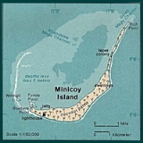
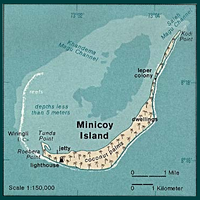 Maliku Atoll has a lagoon with two entrances in its northern side, Saalu Magu on the northeast and Kandimma Magu on the northwest. Its western side is fringed by a narrow reef and coral rocks awash. The interior of the lagoon is sandy and of moderate depth, rarely reaching 4m. It has some coral patches.
is the traditional name of the broad channel between Minicoy (Maliku) and Ihavandippulhu (Haa Alif Atoll) in the Maldives. In the Admiralty Charts it is called Eight Degree Channel. Other names for this channel are Addigiri Kandu and Māmalē Kandu. It appeared in old French maps with the name Courant de Malicut.
of historical Maldives
before mid 16th century. In December 1976, India and the Maldives signed a maritime boundary treaty whereby Maliku was placed on the Indian side of the boundary.
However, on 26 July 1982, Abdulla Hameed
, the half-brother of Maldivian president Maumoon Abdul Gayoom
and the Minister of Atolls for the Maldivian government, gave a speech in which he declared that Minicoy Island was part of the Maldives. The speech caused a minor diplomatic crisis between India and the Maldives, and Gayoom clarified that the speech was intended to highlight the linguistic, cultural, and religious ties between the Maldives and Minicoy and that the Maldives was not intending to make a political claim over the atoll.
Atoll
An atoll is a coral island that encircles a lagoon partially or completely.- Usage :The word atoll comes from the Dhivehi word atholhu OED...
of the Union Territory of Lakshadweep
Lakshadweep
Lakshadweep , formerly known as the Laccadive, Minicoy, and Amindivi Islands, is a group of islands in the Laccadive Sea, 200 to 440 km off the coast of the South West Indian state of Kerala...
, India
India
India , officially the Republic of India , is a country in South Asia. It is the seventh-largest country by geographical area, the second-most populous country with over 1.2 billion people, and the most populous democracy in the world...
. It is located 201 km to the SSW of Kalpeni
Kalpeni
Kalpeni is an inhabited island in the Union Territory of Lakshadweep, India. It lies 71 km south of Androth and 201 km to the NNE of Minicoy, with the broad Nine Degree Channel between them...
, at the southern end of the Nine Degree Channel
Nine Degree Channel
The Nine Degree Channel is a channel in the Indian Ocean between the Laccadive Islands of Kalpeni and Suheli Par, and Maliku Atoll. These two subgroups of islands, together with the Amindivi Subgroup, form the Indian Union Territory of Lakshadweep....
and 125 km to the north of Thuraakunu, Maldives
Maldives
The Maldives , , officially Republic of Maldives , also referred to as the Maldive Islands, is an island nation in the Indian Ocean formed by a double chain of twenty-six atolls oriented north-south off India's Lakshadweep islands, between Minicoy Island and...
, at the northern end of the Eight Degree Channel. The atoll is 10 km in length, having a maximum breadth of about 6 km. The closest geographic feature is the Investigator Bank
Investigator Bank
The Investigator Bank is a submerged bank or sunken atoll in the Union Territory of Lakshadweep, India. It is located 31 km to the northeast of Minicoy Island in the southern region of the Nine Degree Channel. Its minimum depth is 217 m. Depths in the neighborhood of the bank reach 914 meters...
, a submerged shoal located 31 km to the northeast of this atoll at 8˚32'N, 73˚17'E.
Islands
There are only two islands in this atoll:- MinicoyMinicoyMinicoy, locally known as Maliku is a census town in the Indian union territory of Lakshadweep and was formerly a part of Maldive Islands.-Etymology:...
, a large inhabited island located on the eastern and southeastern side of the lagoon, along the reef fringe. It measures about 10 km from its northern end to its southernmost point and it is about 1 km wide in its southern half, while the northern half is a narrow sandspit, often less than 100 m wide. Minicoy is almost completely covered with coconut trees. One of the few landmarks of the island is a tall lighthouse. Unlike the other islands of the U.T. Lakshadweep, the language spoken in Minicoy is Dhivehi, known locally as Mahl. The island has many cultural affinities with the Maldives. - Viringili, a small islet located on the southwestern reef edge. It is barely 200 m in length. Formerly the lepersLeprosyLeprosy or Hansen's disease is a chronic disease caused by the bacteria Mycobacterium leprae and Mycobacterium lepromatosis. Named after physician Gerhard Armauer Hansen, leprosy is primarily a granulomatous disease of the peripheral nerves and mucosa of the upper respiratory tract; skin lesions...
of Minicoy were banished to this island where they lived in abject conditions.
Maliku Kandu
Maliku KanduMaliku Kandu
Maliku Kandu and Māmalē Kandu Divehi are the traditional names of the broad Minicoy Channel between Minicoy and Ihavandippolhu in the north of the Maldives...
is the traditional name of the broad channel between Minicoy (Maliku) and Ihavandippulhu (Haa Alif Atoll) in the Maldives. In the Admiralty Charts it is called Eight Degree Channel. Other names for this channel are Addigiri Kandu and Māmalē Kandu. It appeared in old French maps with the name Courant de Malicut.
History
Maliku Atoll has been under Indian administrations since mid 16th century. It was the northernmost atollAtoll
An atoll is a coral island that encircles a lagoon partially or completely.- Usage :The word atoll comes from the Dhivehi word atholhu OED...
of historical Maldives
Maldives
The Maldives , , officially Republic of Maldives , also referred to as the Maldive Islands, is an island nation in the Indian Ocean formed by a double chain of twenty-six atolls oriented north-south off India's Lakshadweep islands, between Minicoy Island and...
before mid 16th century. In December 1976, India and the Maldives signed a maritime boundary treaty whereby Maliku was placed on the Indian side of the boundary.
However, on 26 July 1982, Abdulla Hameed
Abdulla Hameed
Abdulla Hameed is a Maldivian politician who was Minister of Atolls during the administration of his half-brother Maumoon Abdul Gayoom. Hameed was the Speaker of the Majlis until 2004...
, the half-brother of Maldivian president Maumoon Abdul Gayoom
Maumoon Abdul Gayoom
Maumoon Abdul Gayoom was President of the Maldives from 1978 to 2008. After serving as Minister of Transport, he was nominated as President by the Majlis of the Maldives and succeeded Ibrahim Nasir on November 11, 1978. He eventually became the longest-ruling head of government in Asia...
and the Minister of Atolls for the Maldivian government, gave a speech in which he declared that Minicoy Island was part of the Maldives. The speech caused a minor diplomatic crisis between India and the Maldives, and Gayoom clarified that the speech was intended to highlight the linguistic, cultural, and religious ties between the Maldives and Minicoy and that the Maldives was not intending to make a political claim over the atoll.