

Mae Sariang
Encyclopedia
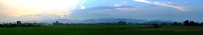
Mae Sariang is a small town and district (Amphoe
) alongside the Yuam River in Mae Hong Son Province
, northern Thailand
, along the Myanmar border. The areas around Mae Sariang are mountainous and forested. The area has many links to Burma, such as its architecture
and a large population of Burmese
Muslims.
of Mae Hong Son Province, Mae Chaem
, Hot
of Chiang Mai Province
, Sop Moei
of Mae Hong Son Province
again Kayin State
and Kayah State
of Myanmar
.
The Salawin National Park
is located in the district.
The important river of Mae Sariang is the Yuam River.
 The district is subdivided into 7 subdistricts (tambon
), which are further subdivided into 77 villages (muban
). Mae Sariang is also a subdistrict municipality (thesaban tambon) which covers parts of the tambon Ban Kat and Mae Sariang. There are further 7 Tambon administrative organizations (TAO).
Number 7 is not used.
Amphoe
An amphoe is the second level administrative subdivision of Thailand. Usually translated as district, amphoe make up the provinces, and are analogous to a county seat...
) alongside the Yuam River in Mae Hong Son Province
Mae Hong Son Province
Most of the areas of Mae Hong Son Province are complex mountain ranges and likely still pristine virgin forest. Of the approximately 6,976,650 rai of national forest reserves, 88.02% is thought to be pristine virgin forest...
, northern Thailand
Thailand
Thailand , officially the Kingdom of Thailand , formerly known as Siam , is a country located at the centre of the Indochina peninsula and Southeast Asia. It is bordered to the north by Burma and Laos, to the east by Laos and Cambodia, to the south by the Gulf of Thailand and Malaysia, and to the...
, along the Myanmar border. The areas around Mae Sariang are mountainous and forested. The area has many links to Burma, such as its architecture
Architecture
Architecture is both the process and product of planning, designing and construction. Architectural works, in the material form of buildings, are often perceived as cultural and political symbols and as works of art...
and a large population of Burmese
Bamar
The Bamar are the dominant ethnic group of Burma , constituting approximately two-thirds of the population. The Bamar live primarily in the Irrawaddy basin, and speak the Burmese language, which is also the official language of Burma. Bamar customs and identity are closely intertwined with general...
Muslims.
Geography
Neighboring are (from north clockwise) Mae La NoiAmphoe Mae La Noi
Mae La Noi is a district in the southern part of Mae Hong Son Province, northern Thailand.-History:The minor district was created on February 10 1967, consisting of the two tambon Mae La Noi and Mae La Luang. It was made a subordinate of Mae Sariang district, from which the tambon Mae La Noi was...
of Mae Hong Son Province, Mae Chaem
Amphoe Mae Chaem
Mae Chaem is a district of Chiang Mai Province in northern Thailand.-History:The district Mueang Chaem was created in 1908, consisting of the tambon Mae Thap,Tha Pha, Chang Khoeng and Mae Suek split off from Chom Thong. In 1917 it was renamed to Chang Khoeng, as the district office was located in...
, Hot
Amphoe Hot
Hot is a district in the southern part of Chiang Mai Province in northern Thailand.-Geography:Neighboring districts are Mae Chaem, Chom Thong of Chiang Mai Province, Ban Hong, Li of Lamphun Province, Doi Tao, Omkoi of Chiang Mai Province again, Sop Moei and Mae Sariang of Mae Hong Son...
of Chiang Mai Province
Chiang Mai Province
Chiang Mai is the second-largest province of Thailand, located in the north of the country. Neighboring provinces are Chiang Rai, Lampang, Lamphun, Tak, and Mae Hong Son. In the north it borders Shan State of Burma...
, Sop Moei
Amphoe Sop Moei
Sop Moei is the southernmost district of Mae Hong Son Province, northern Thailand.-History:Tambon Sop Moei, Mae Khatuan and Kong Koi were separated from Mae Sariang district to create Sop Moei minor district on April 1 1984...
of Mae Hong Son Province
Mae Hong Son Province
Most of the areas of Mae Hong Son Province are complex mountain ranges and likely still pristine virgin forest. Of the approximately 6,976,650 rai of national forest reserves, 88.02% is thought to be pristine virgin forest...
again Kayin State
Kayin State
Kayin State is a state of Burma . The capital city is Hpa-an.-History:The region that forms today's Kayin State was part of successive Burmese kingdoms since the formation of the Pagan Empire in mid-11th century...
and Kayah State
Kayah State
Kayah State is a state of Myanmar. Situated in eastern Myanmar, it is bounded on the north by Shan State, on the east by Thailand's Mae Hong Son Province, and on the south and west by Kayin State. It lies approximately between 18° 30' and 19° 55' north latitude and between 94°40' and 97° 93' east...
of Myanmar
Myanmar
Burma , officially the Republic of the Union of Myanmar , is a country in Southeast Asia. Burma is bordered by China on the northeast, Laos on the east, Thailand on the southeast, Bangladesh on the west, India on the northwest, the Bay of Bengal to the southwest, and the Andaman Sea on the south....
.
The Salawin National Park
Salawin National Park
The Salawin National Park is located in Mae Sariang and Sop Moei Districts in Mae Hong Son Province, northern Thailand, adjacent to its border with Burma. Much of the Salween River is included in the park. The terrain is mountainous jungle and rocky river...
is located in the district.
The important river of Mae Sariang is the Yuam River.
History
1900 the administration in the area was formalized as a district under Mae Hong Song. Originally the district was named Mueang Yuam (เมืองยวม), which was changed in 1917 to Mae Sariang.Administration
Tambon
Tambon is a local government unit in Thailand. Below district and province , they form the third administrative subdivision level. As of the 2009 there are 7255 tambon, not including the 169 khwaeng of Bangkok, which are set at the same administrative level, thus every district contains 8-10 tambon...
), which are further subdivided into 77 villages (muban
Muban
Muban is the lowest administrative subdivision of Thailand. Usually translated as village, they are the subdivision of tambon. As of 2008, there are 74944 administrative villages in Thailand. As of the 1990 census, the average village consisted of 144 households or 746 persons.A muban does not...
). Mae Sariang is also a subdistrict municipality (thesaban tambon) which covers parts of the tambon Ban Kat and Mae Sariang. There are further 7 Tambon administrative organizations (TAO).
| No. | Name | Thai | Villages | Inh. Population A population is all the organisms that both belong to the same group or species and live in the same geographical area. The area that is used to define a sexual population is such that inter-breeding is possible between any pair within the area and more probable than cross-breeding with individuals... |
|---|---|---|---|---|
| 1. | Ban Kat Ban Kat, Mae Sariang Ban Kat is a village and tambon of Mae Sariang District, in Mae Hong Son Province, Thailand. In 2005 it had a total population of 11,283 people. The tambon contains 13 villages.... |
บ้านกาศ | 13 | 11,283 |
| 2. | Mae Sariang Mae Sariang Mae Sariang is a small town and district alongside the Yuam River in Mae Hong Son Province, northern Thailand, along the Myanmar border. The areas around Mae Sariang are mountainous and forested... |
แม่สะเรียง | 9 | 9,968 |
| 3. | Mae Khong Mae Khong Mae Khong is a village and tambon of Mae Sariang District, in Mae Hong Son Province, Thailand. In 2005 it had a total population of 4154 people. The tambon contains 11 villages.... |
แม่คง | 11 | 4,154 |
| 4. | Mae Ho Mae Ho Mae Ho is a village and tambon of Mae Sariang District, in Mae Hong Son Province, Thailand. In 2005 it had a total population of 7813 people. The tambon contains 13 villages.... |
แม่เหาะ | 13 | 7,813 |
| 5. | Mae Yuam Mae Yuam Mae Yuam is a village and tambon of Mae Sariang District, in Mae Hong Son Province, Thailand. In 2005 it had a total population of 9273 people. The tambon contains 13 villages.... |
แม่ยวม | 13 | 9,273 |
| 6. | Sao Hin Sao Hin Sao Hin is a river village and tambon of Mae Sariang District, in Mae Hong Son Province, Thailand. In 2005 it had a total population of 2691 people. The tambon contains 6 villages.... |
เสาหิน | 6 | 2,691 |
| 8. | Pa Pae Pa Pae, Mae Sariang Pa Pae is a village and tambon of Mae Sariang District, in Mae Hong Son Province, Thailand. In 2005 it had a total population of 5755 people. The tambon contains 12 villages.... |
ป่าแป๋ | 12 | 5,755 |
Number 7 is not used.
External links
- amphoe.com (Thai)
- http://www.maesariang.go.th/ Website of Mae Sariang municipality
- Salawin National Park