
Madan, Bulgaria
Encyclopedia
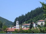
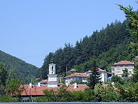
Madan is a town in Smolyan Province
, the very south of Bulgaria
in the Yellow Share of the Rhodope Mountains
. It is the administrative centre of the homonymous Madan Municipality. As of December 2009, the town has a population of 6,007 inhabitants.
 Madan is a part of Ardino Ridge, sloping down to the northeast between the rivers Arda
and Varbitsa
. In the central part of the Yellow Share rise the peaks Buchovitsa (1404 m), Veternitsa (1372 m) and Petrovitsa (1309 m).
 The end of the ridge is Alada Peak (1241 m). From all sides the Yellow Share is separated by mountain-spurs, whose segmentations gradually slope down and vanish into the valleys of the rivers. The river system of the region is presented by the basins of the upper reaches of some of the longer rivers – to the north the basin of the Arda River with the headers Elhovska and Chepinska Rivers.
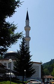
Most of the town's population consists of local Muslim Bulgarians due to the Ottoman invasion of the late 14th century. Тhere is a minority of Eastern Orthodox Bulgarians
. Part of them came as refugeees from Greece and Turkey or during the Communist period (1944–1989) to work in the mines. It is, however, important to note that Madan was fully integrated in the first and second Bulgarian empires long before the arrival of the Ottomans to this part of the Balkans.
on Smith Island
, South Shetland Islands
is named after Madan.
Smolyan Province
-Religion:The Smolyan province along with the Kardzhali Province is a province where the predominant religion is not Orthodox Christianity but Islam. However, unlike Kardzhali where the majority of the population is Turkish, the Muslim population of the Smolyan province is made up almost entirely...
, the very south of Bulgaria
Bulgaria
Bulgaria , officially the Republic of Bulgaria , is a parliamentary democracy within a unitary constitutional republic in Southeast Europe. The country borders Romania to the north, Serbia and Macedonia to the west, Greece and Turkey to the south, as well as the Black Sea to the east...
in the Yellow Share of the Rhodope Mountains
Rhodope Mountains
The Rhodopes are a mountain range in Southeastern Europe, with over 83% of its area in southern Bulgaria and the remainder in Greece. Its highest peak, Golyam Perelik , is the seventh highest Bulgarian mountain...
. It is the administrative centre of the homonymous Madan Municipality. As of December 2009, the town has a population of 6,007 inhabitants.
Geography
Arda River (Maritsa)
The Arda is a river whose source lies in the Bulgarian Rhodope Mountains near the town of Smolyan, flowing 290 kilometres eastward past Kardzhali and Ivaylovgrad and through Greece in the northern portion of the Evros prefecture including Kastanies. It then enters the Maritsa just west of Edirne,...
and Varbitsa
Varbitsa
Varbitsa is a river in the Eastern Rhodope mountains in Bulgaria.The Varbitsa river, a tributary to the Arda, the main river of the Rhodope Mountains, runs through 8 municipalities, 6 of them within the region of Kardjali and 2 in the region of Smolyan...
. In the central part of the Yellow Share rise the peaks Buchovitsa (1404 m), Veternitsa (1372 m) and Petrovitsa (1309 m).
History and population
Madan is an ancient ore-miners' settlement, the extraction of lead ore having begun around 5th-4th century BC.Most of the town's population consists of local Muslim Bulgarians due to the Ottoman invasion of the late 14th century. Тhere is a minority of Eastern Orthodox Bulgarians
Bulgarians
The Bulgarians are a South Slavic nation and ethnic group native to Bulgaria and neighbouring regions. Emigration has resulted in immigrant communities in a number of other countries.-History and ethnogenesis:...
. Part of them came as refugeees from Greece and Turkey or during the Communist period (1944–1989) to work in the mines. It is, however, important to note that Madan was fully integrated in the first and second Bulgarian empires long before the arrival of the Ottomans to this part of the Balkans.
Honour
Madan SaddleMadan Saddle
Madan Saddle is a saddle of elevation 1110 m in Imeon Range on Smith Island, South Shetland Islands bounded by Neofit Peak to the northeast and Riggs Peak to the south-southwest. Overlooking Gramada Glacier to the southeast. Bulgarian early mapping in 2009. Named after the town of Madan in the...
on Smith Island
Smith Island (South Shetland Islands)
Smith Island is long and wide, lying west of Deception Island in the South Shetland Islands of the British Antarctic Territory. Surface area ....
, South Shetland Islands
South Shetland Islands
The South Shetland Islands are a group of Antarctic islands, lying about north of the Antarctic Peninsula, with a total area of . By the Antarctic Treaty of 1959, the Islands' sovereignty is neither recognized nor disputed by the signatories and they are free for use by any signatory for...
is named after Madan.