
.gif)
M3 motorway (Northern Ireland)
Encyclopedia
The M3 is an urban
motorway 0.8 miles (1.3 km) in length owned by Siac Construction and Cintra, S.A. that connects the M2
in north Belfast
, Northern Ireland
to the A2 Sydenham Bypass
in east Belfast. It is the shortest motorway in Northern Ireland, and one of the busiest, carrying 60,000 vehicles per day as of 2005. Whilst classed as a motorway it has a permanent speed limit of 50 mph (80 km/h).
dual-carriageway and only partially completed. Traffic had to make do with crossing the River Lagan on the Queen's Bridge
and using the A2 to Bangor.
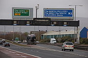 However in 1987 the government announced a plan to build a new bridge across the Lagan connecting the M2 directly to the A2. It was built in two stages: the Lagan Bridge section connecting to the M2 opened on 22 January 1995 while the link to the A2 opened three years later in May 1998. The route was designated as the M3, although it is not the same scheme as the one originally expected to be the M3. Construction of this road was unusual as government policy was against the construction of new urban motorways.
Urban area
An urban area is characterized by higher population density and vast human features in comparison to areas surrounding it. Urban areas may be cities, towns or conurbations, but the term is not commonly extended to rural settlements such as villages and hamlets.Urban areas are created and further...
motorway 0.8 miles (1.3 km) in length owned by Siac Construction and Cintra, S.A. that connects the M2
M2 motorway (Northern Ireland)
The M2 is a motorway in Belfast and County Antrim in Northern Ireland. It is in two sections, the southern section running from north Belfast to Antrim and the northern section acts as a bypass of Ballymena, with the A26 road linking the two sections. In total it is 22 miles...
in north Belfast
Belfast
Belfast is the capital of and largest city in Northern Ireland. By population, it is the 14th biggest city in the United Kingdom and second biggest on the island of Ireland . It is the seat of the devolved government and legislative Northern Ireland Assembly...
, Northern Ireland
Northern Ireland
Northern Ireland is one of the four countries of the United Kingdom. Situated in the north-east of the island of Ireland, it shares a border with the Republic of Ireland to the south and west...
to the A2 Sydenham Bypass
A2 road (Northern Ireland)
The A2 is a major road in Northern Ireland, a large section of which is often called the Antrim Coast Road because it follows the scenic coastline of County Antrim....
in east Belfast. It is the shortest motorway in Northern Ireland, and one of the busiest, carrying 60,000 vehicles per day as of 2005. Whilst classed as a motorway it has a permanent speed limit of 50 mph (80 km/h).
History
The M3 was originally planned in 1956 as the Eastern Approach, named the M3 the following year, which would run from east Belfast to Bangor. The plan was extended to include an orbital Belfast Urban Motorway, close to the city centre, in 1964. However due to a combination of financial cutbacks and public opposition construction of the M3 never took place and the Belfast Urban Motorway was downgraded to the A12 WestlinkWestlink Belfast
The Westlink road in Belfast, Northern Ireland is a dual carriageway throughpass, designated the A12, connecting the M1 to the M2 and M3 motorways which run south, north and east of the city, respectively...
dual-carriageway and only partially completed. Traffic had to make do with crossing the River Lagan on the Queen's Bridge
Queen's Bridge
Queens Bridge is a bridge in Belfast, Northern Ireland. It is one of eight bridges in the city, not to be confused with the adjacent Queen Elizabeth II Bridge. It was opened in 1849.-History:...
and using the A2 to Bangor.
Junctions
| M3 Motorway | ||
| Eastbound exits | Junction | Westbound exits |
| End of motorway City Centre Belfast Belfast is the capital of and largest city in Northern Ireland. By population, it is the 14th biggest city in the United Kingdom and second biggest on the island of Ireland . It is the seat of the devolved government and legislative Northern Ireland Assembly... , Dublin (A12 Westlink Belfast The Westlink road in Belfast, Northern Ireland is a dual carriageway throughpass, designated the A12, connecting the M1 to the M2 and M3 motorways which run south, north and east of the city, respectively... ) Derry Derry Derry or Londonderry is the second-biggest city in Northern Ireland and the fourth-biggest city on the island of Ireland. The name Derry is an anglicisation of the Irish name Doire or Doire Cholmcille meaning "oak-wood of Colmcille"... , Carrickfergus Carrickfergus Carrickfergus , known locally and colloquially as "Carrick", is a large town in County Antrim, Northern Ireland. It is located on the north shore of Belfast Lough, from Belfast. The town had a population of 27,201 at the 2001 Census and takes its name from Fergus Mór mac Eirc, the 6th century king... (M2 M2 motorway (Northern Ireland) The M2 is a motorway in Belfast and County Antrim in Northern Ireland. It is in two sections, the southern section running from north Belfast to Antrim and the northern section acts as a bypass of Ballymena, with the A26 road linking the two sections. In total it is 22 miles... ) |
- | Start of motorway |
| Lagan Bridge | ||
| Start of motorway | - | End of motorway Bangor Bangor, County Down Bangor is a large town in County Down, Northern Ireland. It is a seaside resort on the southern side of Belfast Lough and within the Belfast Metropolitan Area. Bangor Marina is one of the largest in Ireland, and holds Blue Flag status... (A2 A2 road (Northern Ireland) The A2 is a major road in Northern Ireland, a large section of which is often called the Antrim Coast Road because it follows the scenic coastline of County Antrim.... ) Newtownards Newtownards Newtownards is a large town in County Down, Northern Ireland. It lies at the most northern tip of Strangford Lough, 10 miles east of Belfast, on the Ards Peninsula. Newtownards is the largest town in the Borough of Ards. According to the 2001 Census, it has a population of 27,821 people in... (A20 A20 road (Northern Ireland) The A20 is a road in Northern Ireland. It runs from Belfast to Newtownards and on to Portaferry in County Down.Beginning as the Newtownards Road at the junction of Bridge End close to Belfast city centre, the road runs in an easterly direction through east Belfast... ) Downpatrick Downpatrick Downpatrick is a medium-sized town about 33 km south of Belfast in County Down, Northern Ireland. It is the county town of Down with a rich history and strong connection to Saint Patrick. It had a population of 10,316 at the 2001 Census... , Ballynahinch Ballynahinch Ballynahinch is the name of a number of towns in Ireland:*Ballynahinch, County Down, a town in Northern Ireland*Ballynahinch, County Armagh, a townland in County Armagh, Northern Ireland*Ballynahinch, County Galway in the Republic of Ireland... (A23 A23 road (Ireland) The A23 is an 8.7 mile long road in County Down, in Northern Ireland. The route starts in near the Short Strand district in east Belfast and follows the Castlereagh Road through the southeastern suburbs of the city. Upon passing through the A55 Outer Ring Road, the A23 becomes the Ballygowan Road... ) |
External links
- CBRD Motorway Database - M3 (Northern Ireland)
- Northern Ireland Roads Site
- The Motorway Archive - M3 (Northern Ireland)