
Luentinum
Encyclopedia
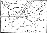
Luentinum was a fort
and mining
settlement in the Roman province
of Britannia
. It was associated with the Dolaucothi Gold Mines
and its remains lie beneath the adjoining village of Pumsaint
in the Welsh
county of Carmarthenshire
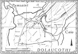
. It lay between similar forts at Llandovery
and Bremia
near Llanio, and some distance away from the fort at Llandeilo
. The Roman road Sarn Helen
linked Luentinum with Llanio and LLandovery.
 Luentinum appears to have been founded as a square 5½ acre
(2.25 hectare
) Roman auxiliary fort controlling the adjoining gold mines, around AD 75 when Frontinus was governor of Roman Britain
and active in subduing the Silures
of Roman Wales. The fort had an earthen rampart and double ditch. The date of first construction was determined from a Samian ware inkwell with stamp in the early 1970s where the river bank had cut into the fort. On the east bank of the River Cothi
, a few hundred yards south of Pumsaint village was discovered a small double-roomed building with hypocaust
and plain tesselated floors. It was probably the military bath-house. The internal buildings of the fort underwent a number of rebuildings until the fort was abandoned around 140. The surrounding civilian vicus
then took over the area and, no doubt, also the mines. The fort is situated about half way between similar forts at Llandovery
to the east and Bremia or Llanio to the west, with Llandeilo
to the south.
. It appears to be related to the Brythonic word for 'washing', as suggested by George Boon of the National Museum of Wales. It refers to the hydraulic mining
methods used on the site for extraction of the gold, and the washing tables used to concentrate the gold dust and nuggets. It is one of the best examples of the application of advanced Roman technology
in Britain, and compares with other Roman mines in Europe such as those at Verespatak in Transylvania
and Las Medulas
in northern Spain
. It is a site of international significance and importance.
Castra
The Latin word castra, with its singular castrum, was used by the ancient Romans to mean buildings or plots of land reserved to or constructed for use as a military defensive position. The word appears in both Oscan and Umbrian as well as in Latin. It may have descended from Indo-European to Italic...
and mining
Mining
Mining is the extraction of valuable minerals or other geological materials from the earth, from an ore body, vein or seam. The term also includes the removal of soil. Materials recovered by mining include base metals, precious metals, iron, uranium, coal, diamonds, limestone, oil shale, rock...
settlement in the Roman province
Roman province
In Ancient Rome, a province was the basic, and, until the Tetrarchy , largest territorial and administrative unit of the empire's territorial possessions outside of Italy...
of Britannia
Britannia
Britannia is an ancient term for Great Britain, and also a female personification of the island. The name is Latin, and derives from the Greek form Prettanike or Brettaniai, which originally designated a collection of islands with individual names, including Albion or Great Britain. However, by the...
. It was associated with the Dolaucothi Gold Mines
Dolaucothi Gold Mines
The Dolaucothi Gold Mines , also known as the Ogofau Gold Mine, are Roman surface and deep mines located in the valley of the River Cothi, near Pumsaint, Carmarthenshire, Wales...
and its remains lie beneath the adjoining village of Pumsaint
Pumsaint
Pumsaint is a village in Carmarthenshire, Wales situated half way between Llanwrda and Lampeter on the A482 in the valley of the River Cothi. It forms part of the extensive estate of Dolaucothi which is owned by the National Trust....
in the Welsh
Wales
Wales is a country that is part of the United Kingdom and the island of Great Britain, bordered by England to its east and the Atlantic Ocean and Irish Sea to its west. It has a population of three million, and a total area of 20,779 km²...
county of Carmarthenshire
Carmarthenshire
Carmarthenshire is a unitary authority in the south west of Wales and one of thirteen historic counties. It is the 3rd largest in Wales. Its three largest towns are Llanelli, Carmarthen and Ammanford...
. It lay between similar forts at Llandovery
Llandovery
Llandovery is a market town in Carmarthenshire, Wales, lying on the River Tywi and the A40 road.The town is served by Llandovery railway station, where there is a park and ride to Llanelli and Shrewsbury via the Heart of Wales Line...
and Bremia
Bremia
Bremia is the name of the Roman fort in Llanio, West Wales. The fort was used by the Romans between AD 75 to AD 120 in Roman Wales. The fort was situated on Sarn Helen , a Roman road leading north from the fort at Dolaucothi. It has produced an inscription dedicated to a cohort from the Asturias,...
near Llanio, and some distance away from the fort at Llandeilo
Llandeilo
Llandeilo is a town in Carmarthenshire, Wales, situated at the crossing of the River Towy by the A483 on a 19th century stone bridge. Its population is 1,731.The town is served by Llandeilo railway station on the Heart of Wales Line.- Early history :...
. The Roman road Sarn Helen
Sarn Helen
right|thumb|250px|A section of Sarn Helen near Betws-y-coed.Sarn Helen was a Roman road in Wales, running from Aberconwy in the north to Carmarthen in the south.It was some 160 miles in length...
linked Luentinum with Llanio and LLandovery.
The Fort
Acre
The acre is a unit of area in a number of different systems, including the imperial and U.S. customary systems. The most commonly used acres today are the international acre and, in the United States, the survey acre. The most common use of the acre is to measure tracts of land.The acre is related...
(2.25 hectare
Hectare
The hectare is a metric unit of area defined as 10,000 square metres , and primarily used in the measurement of land. In 1795, when the metric system was introduced, the are was defined as being 100 square metres and the hectare was thus 100 ares or 1/100 km2...
) Roman auxiliary fort controlling the adjoining gold mines, around AD 75 when Frontinus was governor of Roman Britain
Roman Britain
Roman Britain was the part of the island of Great Britain controlled by the Roman Empire from AD 43 until ca. AD 410.The Romans referred to the imperial province as Britannia, which eventually comprised all of the island of Great Britain south of the fluid frontier with Caledonia...
and active in subduing the Silures
Silures
The Silures were a powerful and warlike tribe of ancient Britain, occupying approximately the counties of Monmouthshire, Breconshire and Glamorganshire of present day South Wales; and possibly Gloucestershire and Herefordshire of present day England...
of Roman Wales. The fort had an earthen rampart and double ditch. The date of first construction was determined from a Samian ware inkwell with stamp in the early 1970s where the river bank had cut into the fort. On the east bank of the River Cothi
River Cothi
The River Cothi is the largest tributary of the River Tywi in south Wales. It is noted for its trout and sea trout fishing and for its beautiful scenery.-Dolaucothi:...
, a few hundred yards south of Pumsaint village was discovered a small double-roomed building with hypocaust
Hypocaust
A hypocaust was an ancient Roman system of underfloor heating, used to heat houses with hot air. The word derives from the Ancient Greek hypo meaning "under" and caust-, meaning "burnt"...
and plain tesselated floors. It was probably the military bath-house. The internal buildings of the fort underwent a number of rebuildings until the fort was abandoned around 140. The surrounding civilian vicus
Vicus (Rome)
In ancient Rome, the vicus was a neighborhood. During the Republican era, the four regiones of the city of Rome were subdivided into vici. In the 1st century BC, Augustus reorganized the city for administrative purposes into 14 regions, comprising 265 vici. Each vicus had its own board of...
then took over the area and, no doubt, also the mines. The fort is situated about half way between similar forts at Llandovery
Llandovery
Llandovery is a market town in Carmarthenshire, Wales, lying on the River Tywi and the A40 road.The town is served by Llandovery railway station, where there is a park and ride to Llanelli and Shrewsbury via the Heart of Wales Line...
to the east and Bremia or Llanio to the west, with Llandeilo
Llandeilo
Llandeilo is a town in Carmarthenshire, Wales, situated at the crossing of the River Towy by the A483 on a 19th century stone bridge. Its population is 1,731.The town is served by Llandeilo railway station on the Heart of Wales Line.- Early history :...
to the south.
Ptolemy
The name Luentinum appears only in Ptolemy's GeographiaGeographia (Ptolemy)
The Geography is Ptolemy's main work besides the Almagest...
. It appears to be related to the Brythonic word for 'washing', as suggested by George Boon of the National Museum of Wales. It refers to the hydraulic mining
Hydraulic mining
Hydraulic mining, or hydraulicking, is a form of mining that uses high-pressure jets of water to dislodge rock material or move sediment. In the placer mining of gold or tin, the resulting water-sediment slurry is directed through sluice boxes to remove the gold.-Precursor - ground...
methods used on the site for extraction of the gold, and the washing tables used to concentrate the gold dust and nuggets. It is one of the best examples of the application of advanced Roman technology
Roman technology
Roman technology is the engineering practice which supported Roman civilization and made the expansion of Roman commerce and Roman military possible over nearly a thousand years....
in Britain, and compares with other Roman mines in Europe such as those at Verespatak in Transylvania
Transylvania
Transylvania is a historical region in the central part of Romania. Bounded on the east and south by the Carpathian mountain range, historical Transylvania extended in the west to the Apuseni Mountains; however, the term sometimes encompasses not only Transylvania proper, but also the historical...
and Las Medulas
Las Médulas
Las Médulas is a historical site near the town of Ponferrada in the region of El Bierzo , which used to be the most important gold mine in the Roman Empire...
in northern Spain
Spain
Spain , officially the Kingdom of Spain languages]] under the European Charter for Regional or Minority Languages. In each of these, Spain's official name is as follows:;;;;;;), is a country and member state of the European Union located in southwestern Europe on the Iberian Peninsula...
. It is a site of international significance and importance.