

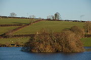
Loughbrickland Crannog
Encyclopedia
Bronze Age
The Bronze Age is a period characterized by the use of copper and its alloy bronze as the chief hard materials in the manufacture of some implements and weapons. Chronologically, it stands between the Stone Age and Iron Age...
man-made island known as a crannóg
Crannog
A crannog is typically a partially or entirely artificial island, usually built in lakes, rivers and estuarine waters of Scotland and Ireland. Crannogs were used as dwellings over five millennia from the European Neolithic Period, to as late as the 17th/early 18th century although in Scotland,...
, four miles (6.5 km) south west of Banbridge
Banbridge
Banbridge is a town in County Down, Northern Ireland. It lies on the River Bann and the A1 road. It was named after a bridge built over the Bann in 1712. The town grew as a coaching stop on the road from Belfast to Dublin and thrived from Irish linen manufacturing...
, County Down
County Down
-Cities:*Belfast *Newry -Large towns:*Dundonald*Newtownards*Bangor-Medium towns:...
, Northern Ireland
Northern Ireland
Northern Ireland is one of the four countries of the United Kingdom. Situated in the north-east of the island of Ireland, it shares a border with the Republic of Ireland to the south and west...
. It is situated in the middle of the lough
Lough
A lough is a body of water and is either:* A lake* A sea lough, which may be a fjord, estuary, bay, or sea inlet.It can also be used as a surname, with various pronunciations: law, loch, low, lowe, loth, loff....
, 1 mile from the village of Loughbrickland. The crannóg in Loughbrickland is a Scheduled Historic Monument in the townland
Townland
A townland or bally is a small geographical division of land used in Ireland. The townland system is of Gaelic origin—most townlands are believed to pre-date the Norman invasion and most have names derived from the Irish language...
of Drumnahare, in Banbridge District, at grid reference J1113 4118.. It is easily visible from the south-bound carriageway of the trunk A1
A1 road (Northern Ireland)
The A1 is a major route in Northern Ireland. It runs from Belfast via Lisburn and Banbridge to the border with the Republic of Ireland south of Newry, from where the road continues to Dublin, becoming the N1 road and M1 motorway...
Belfast
Belfast
Belfast is the capital of and largest city in Northern Ireland. By population, it is the 14th biggest city in the United Kingdom and second biggest on the island of Ireland . It is the seat of the devolved government and legislative Northern Ireland Assembly...
-Dublin route, just past the B3 Rathfriland
Rathfriland
Rathfriland is a village in County Down, Northern Ireland. It is a hilltop Plantation of Ulster settlement between the Mourne Mountains, Slieve Croob and Banbridge. It had a population of 2,079 people in the 2001 Census.-History:...
exit.
Features
Loughbrickland Crannóg, set in the middle of the lake, was surrounded by a row of stakes and partly built up of occupation debris.History
The crannóg is a man-made island dating from around the Late Bronze Age period (from approx. 2000 to 500 BC). It was later, in the 17th century, inhabited by the Magennis family, who had vacated a castle that is thought to have been located on the lake shore. It was the site of a skirmish in the 1642 uprisingIrish Rebellion of 1641
The Irish Rebellion of 1641 began as an attempted coup d'état by Irish Catholic gentry, who tried to seize control of the English administration in Ireland to force concessions for the Catholics living under English rule...
when it was used as a hiding place by rebels.
The Loughbrickland Community Association adopted an image of the crannóg as its logo and this appears on waymarks and signs along the Loughbrickland Historic Trail.