

Lost Blue Bucket Mine
Encyclopedia
Lost mines
Lost mines are a popular form of lost treasure legend. The mine involved is usually of a high-value commodity such as gold, silver or diamonds. Often there is a map purportedly showing the location of the mine...
reputed to be located along the Meek Wagon Train trail between the present day cities of Vale
Vale, Oregon
Vale is a city in Malheur County, Oregon, United States, about west of the Idaho border. It is at the intersection of U.S. Routes 20 and 26, on the Malheur River.Vale was selected as Malheur's county seat in 1955, 68 years after the county was founded...
and The Dalles
The Dalles, Oregon
The Dalles is the largest city and county seat of Wasco County, Oregon, United States. The name of the city comes from the French word dalle The Dalles is the largest city and county seat of Wasco County, Oregon, United States. The name of the city comes from the French word dalle The Dalles is...
in Oregon
Oregon
Oregon is a state in the Pacific Northwest region of the United States. It is located on the Pacific coast, with Washington to the north, California to the south, Nevada on the southeast and Idaho to the east. The Columbia and Snake rivers delineate much of Oregon's northern and eastern...
, United States. Its existence traces back to 1845, several years before the California Gold Rush
California Gold Rush
The California Gold Rush began on January 24, 1848, when gold was found by James W. Marshall at Sutter's Mill in Coloma, California. The first to hear confirmed information of the gold rush were the people in Oregon, the Sandwich Islands , and Latin America, who were the first to start flocking to...
.
Points of agreement
The various versions of the legend tend to agree on a few key points http://www.thegeozone.com/treasure/nevada/tales/nv002a.jsp:- Lost Oregon-bound emigrants discovered it in summer 1845,
- The deposit is coarse placer gold in a dry stream bedStream bedA stream bed is the channel bottom of a stream, river or creek; the physical confine of the normal water flow. The lateral confines or channel margins, during all but flood stage, are known as the stream banks or river banks. In fact, a flood occurs when a stream overflows its banks and flows onto...
or canyonCanyonA canyon or gorge is a deep ravine between cliffs often carved from the landscape by a river. Rivers have a natural tendency to reach a baseline elevation, which is the same elevation as the body of water it will eventually drain into. This forms a canyon. Most canyons were formed by a process of...
, - The canyon is bottomed with lavaLavaLava refers both to molten rock expelled by a volcano during an eruption and the resulting rock after solidification and cooling. This molten rock is formed in the interior of some planets, including Earth, and some of their satellites. When first erupted from a volcanic vent, lava is a liquid at...
pocked with cavities and potholes.
Versions of the legend
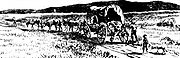
One version states that a wagon trainWagon train
A wagon train is a group of wagons traveling together. In the American West, individuals traveling across the plains in covered wagons banded together for mutual assistance, as is reflected in numerous films and television programs about the region, such as Audie Murphy's Tumbleweed and Ward Bond...
got lost off the Meek Cutoff of the Oregon Trail
Oregon Trail
The Oregon Trail is a historic east-west wagon route that connected the Missouri River to valleys in Oregon and locations in between.After 1840 steam-powered riverboats and steamboats traversing up and down the Ohio, Mississippi and Missouri rivers sped settlement and development in the flat...
, near the Malheur River
Malheur River
The Malheur River is a tributary of the Snake River in eastern Oregon in the United States. It drains a high desert area, between the Harney Basin and the Blue Mountains and the Snake....
. Three young men (or boys, or a single girl — accounts vary) went to fetch water, and while doing so put some shiny rocks into a blue bucket. Older members of the party said it was copper
Copper
Copper is a chemical element with the symbol Cu and atomic number 29. It is a ductile metal with very high thermal and electrical conductivity. Pure copper is soft and malleable; an exposed surface has a reddish-orange tarnish...
. Someone asked, "Was there much of it?". One replied, "We could have filled one of these blue buckets". This was 1845, before the California Gold Rush
California Gold Rush
The California Gold Rush began on January 24, 1848, when gold was found by James W. Marshall at Sutter's Mill in Coloma, California. The first to hear confirmed information of the gold rush were the people in Oregon, the Sandwich Islands , and Latin America, who were the first to start flocking to...
, and back then many could not recognize gold
Gold
Gold is a chemical element with the symbol Au and an atomic number of 79. Gold is a dense, soft, shiny, malleable and ductile metal. Pure gold has a bright yellow color and luster traditionally considered attractive, which it maintains without oxidizing in air or water. Chemically, gold is a...
. A Mrs. Fisher kept one nugget
Gold nugget
A gold nugget is a naturally occurring piece of native gold. Watercourses often concentrate and grow the nuggets. Nuggets are recovered by placer mining, but they are also found in residual deposits where the gold-bearing veins or lodes are weathered...
and left the rest behind. The wagons eventually reached what is now The Dalles, Oregon
The Dalles, Oregon
The Dalles is the largest city and county seat of Wasco County, Oregon, United States. The name of the city comes from the French word dalle The Dalles is the largest city and county seat of Wasco County, Oregon, United States. The name of the city comes from the French word dalle The Dalles is...
in October, 1845. The single nugget was eventually recognized as gold.
Another version holds that when the Stephen Meek
Stephen Meek
Stephen Hall Meek was a fur trapper and guide in the American west, most notably a guide on a large wagon train known as St. Joseph's Company...
Wagon train stopped along the trail in present-day Crook County
Crook County, Oregon
-Demographics:As of the census of 2000, there were 19,182 people, 7,354 households, and 5,427 families residing in the county. The population density was 6 people per square mile . There were 8,264 housing units at an average density of 3 per square mile...
near Bear Creek, children went to gather water at some distance from the camp. They returned with a blue bucket filled with shiny pebbles. An old-timer in the party stated that the pebbles were made of copper. One of the families, however, kept several of the pebbles as souvenirs. Years later, and after having moved to California, the family came across the pebbles in a dresser drawer. By this time, the California Gold Rush
California Gold Rush
The California Gold Rush began on January 24, 1848, when gold was found by James W. Marshall at Sutter's Mill in Coloma, California. The first to hear confirmed information of the gold rush were the people in Oregon, the Sandwich Islands , and Latin America, who were the first to start flocking to...
had occurred, and the expertise was available to recognize that the pebbles were in fact gold. However, no-one could remember the precise location in which the pebbles had been found.
Results
The legend sparked a gold rushGold rush
A gold rush is a period of feverish migration of workers to an area that has had a dramatic discovery of gold. Major gold rushes took place in the 19th century in Australia, Brazil, Canada, South Africa, and the United States, while smaller gold rushes took place elsewhere.In the 19th and early...
to the area of modern-day Baker City, Oregon
Baker City, Oregon
Baker City is a city in and the county seat of Baker County, Oregon, United States. It was named after Edward D. Baker. The population was 9,828 at the 2010 census.-History:...
, http://www.oregongold.net/tag/baker/.
Current status
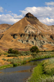
If the mine existed, its location is unknown; the area comprises perhaps 40000 square miles (103,599.5 km²) http://www.thegeozone.com/treasure/nevada/tales/nv002a.jsp. It is believed to be on a tributaryTributary
A tributary or affluent is a stream or river that flows into a main stem river or a lake. A tributary does not flow directly into a sea or ocean...
of the John Day River
John Day River
The John Day River is a tributary of the Columbia River, approximately long, in northeastern Oregon in the United States. Undammed along its entire length, the river is the third longest free-flowing river in the conterminous United States. There is extensive use of its waters for irrigation. Its...
, or in another version, on a Bear Creek tributary of the Crooked River. There are three real mines
Mining
Mining is the extraction of valuable minerals or other geological materials from the earth, from an ore body, vein or seam. The term also includes the removal of soil. Materials recovered by mining include base metals, precious metals, iron, uranium, coal, diamonds, limestone, oil shale, rock...
in the U.S. named the "Blue Bucket", including one in Grant County, that are unrelated to the lost mine.