

Lodhi Road
Encyclopedia
Lodhi Road in New Delhi
, India, is named after the Lodhi Gardens located on it. Two Mughal
mausoleums, Humayun's Tomb
and Safdarjung's Tomb
, lie at the eastern and western ends of the road respectively. A number of cultural, educational, and international institutions line the road. The Jor Bagh
metro station lies under Aurobindo Marg near its intersection with Lodhi Road. Also located near it are Lodhi colony
and Lodhi Estate built during British Raj
in 1940s , and Lodhi Road Institutional Area.
's troops in 1398.
The road has always marked a boundary between neighbouring settlements. During the 15th century it divided the Kotla Mubarakpur
(of the Sayyid
s) from the necropolis of the Lodis. In the 16th and 17th centuries it marked the boundary between the Delhi
and Mehrauli
tehsil
s. The masonry bridge over the now dried-up rivulet of Jaitpur (the village occupying the site razed by the British in 1912) is a reminder of Mughal
Emperor Akbar's interest in the region. By the late 18th century the road marked the edge of the then controversial Shia enclave of Alipur, which contained the remains, houses, and troops of some estranged Persian nobles of the later Mughal court.
 The road marked the edge of the original New Delhi Plan, and still defines the Lutyens Bungalow Zone (Lutyens' Delhi
). Almost all the trees lining New Delhi's avenues can be traced to the Lodhi Road nursery, created as New Delhi was being planned. The road was significantly widened in preparation for the Asian Games of 1982.
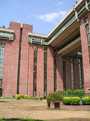
The post-independence spurt of institutions constructed along Lodhi Road began with Nehru's gift of some minor bungalow plots to the India International Center (IIC). The Ford Foundation
, the architectural input of Joseph Allen Stein
, the "brown sahib" bureaucrat nexus, and the approval of the Indian government, allowed the gradual growth of institutions built in a sultanate-cum-prairie architectural style extending as far as the Lodhi tombs in Lodhi Gardens, which Stein re-landscaped in 1968.
The Metereological Department was soon followed by the international development community active in Delhi during the 1960s. UNICEF, WHF, and others acquired plots in what was developing into an enclave for the diplomatic and government elite. Subsequently the Chinmaya Mission
, World Bank
, INTACH and India Habitat Centre
(IHC) constructed buildings in sympathetic materials and architectural styles. The area was referred to as Steinabad, and Stein remained involved with the construction until the early 1990s. In addition, the Research and Analysis Wing
, India's external intelligence agency, is headquartered at Lodhi Road.
The area is largely an exclusive, elite preserve in the heart of the city, containing the offices of many large Indian companies.
New Delhi
New Delhi is the capital city of India. It serves as the centre of the Government of India and the Government of the National Capital Territory of Delhi. New Delhi is situated within the metropolis of Delhi. It is one of the nine districts of Delhi Union Territory. The total area of the city is...
, India, is named after the Lodhi Gardens located on it. Two Mughal
Mughal (tribe)
The term Mughal is simply a Turkic word and many groups in India, Pakistan, Afghanistan, and Bangladesh use the term Mughal to describe themselves...
mausoleums, Humayun's Tomb
Humayun's Tomb
Humayun's tomb is the tomb of the Mughal Emperor Humayun. The tomb was commissioned by Humayun's wife Hamida Banu Begum in 1562 AD, and designed by Mirak Mirza Ghiyath, a Persian architect...
and Safdarjung's Tomb
Safdarjung's Tomb
Safdarjung's Tomb is a garden tomb with a marble mausoleum in New Delhi, India. It was built in 1754 in the late Mughal Empire style, and was described as "the last flicker in the lamp of Mughal architecture". The top storey of the edifice houses the Archaeological Survey of India...
, lie at the eastern and western ends of the road respectively. A number of cultural, educational, and international institutions line the road. The Jor Bagh
Jor Bagh (Delhi Metro)
The Jor Bagh Metro Station is located on the Yellow Line of the Delhi Metro.It is the northern-most station on Aurobindo Marg, and is located near the Lodhi Road crossing. A Mughal mausoleum, Safdarjung's Tomb, is located nearby. It is also close to Safdarjung Airport....
metro station lies under Aurobindo Marg near its intersection with Lodhi Road. Also located near it are Lodhi colony
Lodhi colony
Lodhi Colony Lodhi Colony Lodhi Colony (Hindi:लोधी कालोनी] (Urdu:لودی کالونی) is a Central Government Officers and Staff Residential Colony in South Central part of New Delhi, built in the 1940s, and lies close to Lodhi Road.-History:...
and Lodhi Estate built during British Raj
British Raj
British Raj was the British rule in the Indian subcontinent between 1858 and 1947; The term can also refer to the period of dominion...
in 1940s , and Lodhi Road Institutional Area.
History
The road follows a 14th-century dirt track connecting Ghiyathpur (now Nizamuddin) village with the Bagh-i Jud (from which the present day Jor Bagh is derived), one of the earliest orchards mentioned in Sultanate records, before joining the larger road from Rewari and Gurgaon. It has been used by invading armies, most famously by TimurTimur
Timur , historically known as Tamerlane in English , was a 14th-century conqueror of West, South and Central Asia, and the founder of the Timurid dynasty in Central Asia, and great-great-grandfather of Babur, the founder of the Mughal Dynasty, which survived as the Mughal Empire in India until...
's troops in 1398.
The road has always marked a boundary between neighbouring settlements. During the 15th century it divided the Kotla Mubarakpur
Kotla Mubarakpur
Kotla Mubarakpur Complex , a medieval village, is now an upscale market place with a residential colony in South Delhi, India...
(of the Sayyid
Sayyid
Sayyid is an honorific title, it denotes males accepted as descendants of the Islamic prophet Muhammad through his grandsons, Hasan ibn Ali and Husain ibn Ali, sons of the prophet's daughter Fatima Zahra and his son-in-law Ali ibn Abi Talib.Daughters of sayyids are given the titles Sayyida,...
s) from the necropolis of the Lodis. In the 16th and 17th centuries it marked the boundary between the Delhi
Delhi
Delhi , officially National Capital Territory of Delhi , is the largest metropolis by area and the second-largest by population in India, next to Mumbai. It is the eighth largest metropolis in the world by population with 16,753,265 inhabitants in the Territory at the 2011 Census...
and Mehrauli
Mehrauli
Mehrauli is a neighbourhood in the South West district of Delhi in India. It represents a constituency in the legislative assembly of Delhi. The area is located close to Gurgaon.-History:...
tehsil
Tehsil
A Tehsil or Tahsil/Tahasil , also known as Taluk and Mandal, is an administrative division of some country/countries of South Asia....
s. The masonry bridge over the now dried-up rivulet of Jaitpur (the village occupying the site razed by the British in 1912) is a reminder of Mughal
Mughal Empire
The Mughal Empire , or Mogul Empire in traditional English usage, was an imperial power from the Indian Subcontinent. The Mughal emperors were descendants of the Timurids...
Emperor Akbar's interest in the region. By the late 18th century the road marked the edge of the then controversial Shia enclave of Alipur, which contained the remains, houses, and troops of some estranged Persian nobles of the later Mughal court.
Overview
Lutyens' Delhi
Lutyens' Delhi is an area in Delhi, specifically New Delhi, India, named after the leading British architect Edwin Lutyens , who was responsible for much of the architectural design and building when India was part of the British Empire in the 1920s and 1930s...
). Almost all the trees lining New Delhi's avenues can be traced to the Lodhi Road nursery, created as New Delhi was being planned. The road was significantly widened in preparation for the Asian Games of 1982.
The post-independence spurt of institutions constructed along Lodhi Road began with Nehru's gift of some minor bungalow plots to the India International Center (IIC). The Ford Foundation
Ford Foundation
The Ford Foundation is a private foundation incorporated in Michigan and based in New York City created to fund programs that were chartered in 1936 by Edsel Ford and Henry Ford....
, the architectural input of Joseph Allen Stein
Joseph Allen Stein
Joseph Stein, was an American architect. An a major figure in the establishment of a regional modern architecture in the San Francisco Bay area in the 1940s and 1950s during the early days of the environmental design movement, he is noted for designing several important buildings in India, most...
, the "brown sahib" bureaucrat nexus, and the approval of the Indian government, allowed the gradual growth of institutions built in a sultanate-cum-prairie architectural style extending as far as the Lodhi tombs in Lodhi Gardens, which Stein re-landscaped in 1968.
The Metereological Department was soon followed by the international development community active in Delhi during the 1960s. UNICEF, WHF, and others acquired plots in what was developing into an enclave for the diplomatic and government elite. Subsequently the Chinmaya Mission
Chinmaya Mission
Chinmaya Mission was founded in 1953 by the devotees of Swami Chinmayananda to 'give organizational structure and cohesiveness to the work and activities initiated by Swami Chinmayananda' . It is administered from Central Chinmaya Mission Trust, Mumbai...
, World Bank
World Bank
The World Bank is an international financial institution that provides loans to developing countries for capital programmes.The World Bank's official goal is the reduction of poverty...
, INTACH and India Habitat Centre
India Habitat Centre
The India Habitat Centre, located in New Delhi, India, was conceived to be a catalyst relationship between individuals and institutions working in habitat related areas to increase their effectiveness...
(IHC) constructed buildings in sympathetic materials and architectural styles. The area was referred to as Steinabad, and Stein remained involved with the construction until the early 1990s. In addition, the Research and Analysis Wing
Research and Analysis Wing
The Research and Analysis Wing is India's external intelligence agency. It was formed in September 1968 after the poor performance of the Intelligence Bureau in the Sino-Indian war of 1962 and the India-Pakistani war of 1965 convinced the then government of India that a specialized, independent...
, India's external intelligence agency, is headquartered at Lodhi Road.
The area is largely an exclusive, elite preserve in the heart of the city, containing the offices of many large Indian companies.
Landmarks
- Aman HotelAmanresortsAmanresorts is a small luxury hotel group, located in 15 countries around the world. The word "Aman" is Urdu for "peace." It is owned by DLF Limited, India's largest real estate company.-History:...
– featuring a 50-metre pool - Air Force Bal Bharati SchoolAir Force Bal Bharati SchoolAir Force Bal Bharati School established 1955, is a senior secondary school situated on Lodi Road, New Delhi, India, and run by the Indian Air Force Educational and Cultural Society...
- Dyal Singh College, DelhiDyal Singh College, DelhiDyal Singh College, Delhi is a college of University of Delhi, established in 1959, and is situated in Delhi. It offers undergraduate as well as postgraduate courses in Science, Humanities and Commerce.-The College:...