
Little Hartley, New South Wales
Encyclopedia
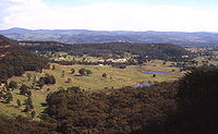
Little Hartley is a village in the Blue Mountains area of New South Wales
, Australia. It is located approximately 150 kilometres west of Sydney
and 20 kilometres south-east of Lithgow, on the Great Western Highway. It is in the Local Government Area of the City of Lithgow
.
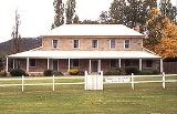
. The most prominent landmarks are Rosedale, on the west side of the highway, and Meads Farm on the east side. Other properties in the area include The Grange (the site of an art gallery), Sheepcombe (formerly William's Store), Ambermere (formerly the Rose Inn), Deloraine Park, Tathra, Nioka, Niangala, Glyn Ruthin, Kariba, Bimbadgen and Bimbimbi. There is a caravan park in Browns Gap Road, a sale yards on the west side of the highway, and a cemetery on the east side.
in 1912. Berghofer renamed the building Rosenthal, but it was eventually renamed Rosedale. It is now listed with the National Trust.
Mead's Farm, located almost two kilometres north-west of Rosedale, dates back to a land grant of forty hectares given to Hugh Beattie in 1856. It was operated as the Kerosene Inn between 1867 and 1880, during which time it was used by the miners who worked at the shale mine in Hartley Vale
. Some of its owners over the years were Louis Meads, from 1872, Captain George Stevens, and Captain Thomas Rowntree, who was an early mayor of Balmain
. Like Rosedale, Meads Farm is listed with the National Trust.
New South Wales
New South Wales is a state of :Australia, located in the east of the country. It is bordered by Queensland, Victoria and South Australia to the north, south and west respectively. To the east, the state is bordered by the Tasman Sea, which forms part of the Pacific Ocean. New South Wales...
, Australia. It is located approximately 150 kilometres west of Sydney
Sydney
Sydney is the most populous city in Australia and the state capital of New South Wales. Sydney is located on Australia's south-east coast of the Tasman Sea. As of June 2010, the greater metropolitan area had an approximate population of 4.6 million people...
and 20 kilometres south-east of Lithgow, on the Great Western Highway. It is in the Local Government Area of the City of Lithgow
City of Lithgow
Lithgow is a Local Government Area in New South Wales, Australia that includes Lithgow and its surrounding area. It is on the Great Western Highway and the Main Western railway line.- Demographics :According to the , there:...
.
Description
Little Hartley is a collection of properties in a rural setting, distributed on both sides of the Great Western HighwayGreat Western Highway
The Great Western Highway is a highway in New South Wales, Australia. It runs 210 km from Sydney to Bathurst.Starting as Broadway at the intersection of City Road near the fringe of the Sydney CBD, and becoming Parramatta Road to Parramatta itself, the Great Western Highway heads due west from...
. The most prominent landmarks are Rosedale, on the west side of the highway, and Meads Farm on the east side. Other properties in the area include The Grange (the site of an art gallery), Sheepcombe (formerly William's Store), Ambermere (formerly the Rose Inn), Deloraine Park, Tathra, Nioka, Niangala, Glyn Ruthin, Kariba, Bimbadgen and Bimbimbi. There is a caravan park in Browns Gap Road, a sale yards on the west side of the highway, and a cemetery on the east side.
History
The most prominent property, Rosedale, was built in 1839 for William Cummings. It was originally licensed as the Coach and Horses, but the name was later changed to Victoria Inn. In 1903 it was acquired by W.J.Berghofer, who was responsible for building Berghofer's Pass at Mount YorkMount York
Mount York is a 1061 metre high mountain in the western Blue Mountains of New South Wales, Australia, located approximately 150 kilometres west of Sydney. It is in fact a projection of the Blue Mountains plateau, creating a promontory of the western escarpment with a minor rise at its...
in 1912. Berghofer renamed the building Rosenthal, but it was eventually renamed Rosedale. It is now listed with the National Trust.
Mead's Farm, located almost two kilometres north-west of Rosedale, dates back to a land grant of forty hectares given to Hugh Beattie in 1856. It was operated as the Kerosene Inn between 1867 and 1880, during which time it was used by the miners who worked at the shale mine in Hartley Vale
Hartley Vale, New South Wales
Hartley Vale is a small village in the Blue Mountains area of New South Wales, Australia. It is approximately 150 kilometres west of Sydney and 12 kilometres south-east of Lithgow. It is in the Local Government Area of the City of Lithgow.-Description:...
. Some of its owners over the years were Louis Meads, from 1872, Captain George Stevens, and Captain Thomas Rowntree, who was an early mayor of Balmain
Balmain, New South Wales
Balmain is a suburb in the inner-west of Sydney, in the state of New South Wales, Australia. Balmain is located slightly west of the Sydney central business district, in the local government area of the Municipality of Leichhardt....
. Like Rosedale, Meads Farm is listed with the National Trust.