List of tributaries of the Gila River
Encyclopedia

Gila River
The Gila River is a tributary of the Colorado River, 650 miles long, in the southwestern states of New Mexico and Arizona.-Description:...
, the final river drainage of the Colorado River
Colorado River
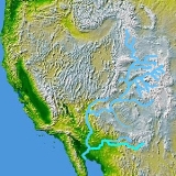
The Colorado River , is a river in the Southwestern United States and northwestern Mexico, approximately long, draining a part of the arid regions on the western slope of the Rocky Mountains. The watershed of the Colorado River covers in parts of seven U.S. states and two Mexican states...
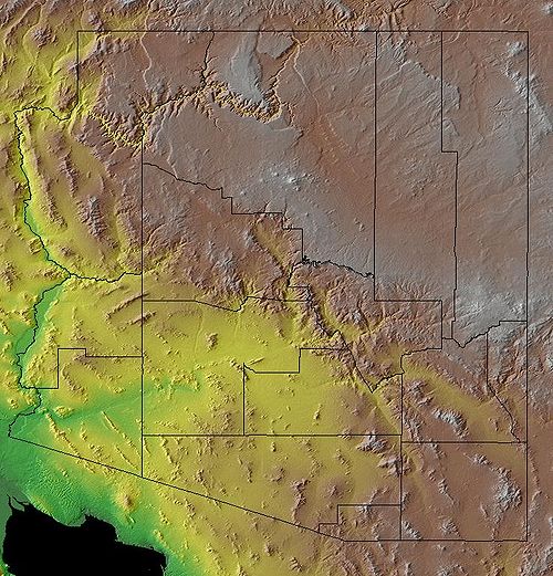
, and covers the entire width of southern Arizona. The headwaters of the Gila River begin in the Gila National Forest
Gila National Forest
The Gila National Forest is a protected national forest in New Mexico in the southwestern United States established in 1905. It covers approximately 3.3 million acres of public land, making it the sixth largest National Forest in the continental United States...
of New Mexico
New Mexico
New Mexico is a state located in the southwest and western regions of the United States. New Mexico is also usually considered one of the Mountain States. With a population density of 16 per square mile, New Mexico is the sixth-most sparsely inhabited U.S...
. The northern branch tributary to the Gila River in the Gila National Forest, is the San Francisco River
San Francisco River
The San Francisco River is a river in the southwest United States, the largest tributary of the Upper Gila River. The river originates in Arizona and flows into New Mexico before it curves around and enters the Gila down stream from Clifton, Arizona....
.
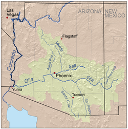
The map highlights the Gila River
Gila River
The Gila River is a tributary of the Colorado River, 650 miles long, in the southwestern states of New Mexico and Arizona.-Description:...
extending eastward across southern Arizona to the southwestern corner of Arizona and its input into the Colorado River
Colorado River
The Colorado River , is a river in the Southwestern United States and northwestern Mexico, approximately long, draining a part of the arid regions on the western slope of the Rocky Mountains. The watershed of the Colorado River covers in parts of seven U.S. states and two Mexican states...
, from its origins about 400 miles east in the southwestern corner of the state of New Mexico
New Mexico
New Mexico is a state located in the southwest and western regions of the United States. New Mexico is also usually considered one of the Mountain States. With a population density of 16 per square mile, New Mexico is the sixth-most sparsely inhabited U.S...
. The highlighted river north and adjacent is the Salt River
Salt River (Arizona)
The Salt River is a stream in the U.S. state of Arizona. It is the largest tributary of the Gila River. The river is about long. Its drainage basin is about large. The longest of the Salt River's many tributaries is the Verde River...
which has the Verde River
Verde River
The Verde River is the north and northwestern watershed of the Salt River–Verde River Watershed that co-join and enter the Gila River at Phoenix, Arizona, located in the U.S. state of Arizona...
connected just prior to its drainage into the Gila River. The Verde and Salt rivers effectively drain the western and central portion of the Mogollon Rim
Mogollon Rim
The Mogollon Rim is a topographical and geological feature running across the U.S. state of Arizona. It extends approximately from northern Yavapai County eastward to near the border with New Mexico.-Description:...
, NW to SE across the state, and the White Mountain region of the Mogollon Rim, in east-central, and east Arizona.
The Verde River drainage into the Salt River, at its very northwestern drainages, east of Kingman, Arizona
Kingman, Arizona
Kingman is located in a desert climate on the edge of the Mojave Desert, but its higher elevation and location between the Colorado Plateau and the Lower Colorado River Valley tempers summer high temperatures and contributes to winter cold and rare snowfall. Summer daytime highs reach above 90 °F ...
, even drains the South Rim, of the Grand Canyon
Grand Canyon
The Grand Canyon is a steep-sided canyon carved by the Colorado River in the United States in the state of Arizona. It is largely contained within the Grand Canyon National Park, the 15th national park in the United States...
. Thus, the Gila River watershed, may cover more than sixty (60) percent of the state.
The 3-north-south drainages + Salt-Verde WatershedSalt River (Arizona)The Salt River is a stream in the U.S. state of Arizona. It is the largest tributary of the Gila River. The river is about long. Its drainage basin is about large. The longest of the Salt River's many tributaries is the Verde River...
From west–to–east the Hassayampa River'sHassayampa River
The Hassayampa River is a mostly underground river, the headwaters of which are just south of Prescott, Arizona, and flows mostly south towards Wickenburg entering the Gila River near Hassayampa, Arizona...
final destination is the dry desert, and groundwater. The second drainage, the Agua Fria River enters the Gila in western Phoenix, but not as a flowing river. The Agua Fria puts most of its winter drainage, or snowmelt/rain floodwaters into Lake Pleasant Regional Park
Lake Pleasant Regional Park
Lake Pleasant Regional Park is a large outdoors recreation area straddling the Maricopa and Yavapai county border northwest of Phoenix, Arizona...
. The largest of the three north/south rivers, the Verde River
Verde River
The Verde River is the north and northwestern watershed of the Salt River–Verde River Watershed that co-join and enter the Gila River at Phoenix, Arizona, located in the U.S. state of Arizona...
(plus the East Verde), goes through Horseshoe Reservoir and Bartlett Reservoir before joining the Salt River
Salt River (Arizona)
The Salt River is a stream in the U.S. state of Arizona. It is the largest tributary of the Gila River. The river is about long. Its drainage basin is about large. The longest of the Salt River's many tributaries is the Verde River...
. (The Salt River enters the Gila, 40 miles downstream, through central Phoenix, and five miles before the Agua Fria River tributary. The Hassayampa River is 35 miles farther downstream, and just prior to the tributary of Centennial Wash
Centennial Wash
Centennial Wash is an ephemeral dry wash that forms the final watershed of the Gila River in central Arizona — before the river turns south. From the Centennial Wash confluence, the Gila turns south, then southwest to exit Arizona on the California border adjacent Yuma.The Centennial Wash drainage...
.)
The Verde River
Verde River
The Verde River is the north and northwestern watershed of the Salt River–Verde River Watershed that co-join and enter the Gila River at Phoenix, Arizona, located in the U.S. state of Arizona...
drainage extends north and northwest of the Agua Fria River, and Hassayampa River drainages, and continues to the South Rim of the Grand Canyon
Grand Canyon
The Grand Canyon is a steep-sided canyon carved by the Colorado River in the United States in the state of Arizona. It is largely contained within the Grand Canyon National Park, the 15th national park in the United States...
. The combined: Salt River–Verde River Drainage would be the major, (and central), component of the Mogollon Rim
Mogollon Rim
The Mogollon Rim is a topographical and geological feature running across the U.S. state of Arizona. It extends approximately from northern Yavapai County eastward to near the border with New Mexico.-Description:...
drainages of central Arizona.
Gila watershed
- Agua Fria River- North
- Centennial WashCentennial WashCentennial Wash is an ephemeral dry wash that forms the final watershed of the Gila River in central Arizona — before the river turns south. From the Centennial Wash confluence, the Gila turns south, then southwest to exit Arizona on the California border adjacent Yuma.The Centennial Wash drainage...
- Eagle CreekEagle Creek (Arizona)Eagle Creek is a river located northwest of Clifton, Arizona, USA, at the base of the White Mountain Range. It is a tributary of the Gila River.- Fish species :* Smallmouth bass* Channel catfish* Flathead catfish* Apache trout* Carp- External links :...
- Gila RiverGila RiverThe Gila River is a tributary of the Colorado River, 650 miles long, in the southwestern states of New Mexico and Arizona.-Description:...
- Hassayampa RiverHassayampa RiverThe Hassayampa River is a mostly underground river, the headwaters of which are just south of Prescott, Arizona, and flows mostly south towards Wickenburg entering the Gila River near Hassayampa, Arizona...
- North - Queen Creek Wash
- Salt RiverSalt River (Arizona)The Salt River is a stream in the U.S. state of Arizona. It is the largest tributary of the Gila River. The river is about long. Its drainage basin is about large. The longest of the Salt River's many tributaries is the Verde River...
- San Carlos River, Arizona–(into San Carlos LakeSan Carlos LakeSan Carlos Lake was formed by the construction of the Coolidge Dam and is rimmed by of shoreline. The lake is located within the San Carlos Apache Indian Reservation, and is thus subject to tribal regulations....
) - San Francisco RiverSan Francisco RiverThe San Francisco River is a river in the southwest United States, the largest tributary of the Upper Gila River. The river originates in Arizona and flows into New Mexico before it curves around and enters the Gila down stream from Clifton, Arizona....
, (Arizona and New Mexico) - San Pedro River, Arizona- South
- San Simon River- Southeast
- Santa Cruz River- South
- Verde RiverVerde RiverThe Verde River is the north and northwestern watershed of the Salt River–Verde River Watershed that co-join and enter the Gila River at Phoenix, Arizona, located in the U.S. state of Arizona...
- North
Arizona watersheds
- NW Ariz(strip): Virgin RiverVirgin RiverThe Virgin River is a tributary of the Colorado River in the U.S. states of Utah, Nevada, and Arizona. The river is about long. It was designated Utah's first wild and scenic river in 2009, during the centennial celebration of Zion National Park.-Course:...
and Lake MeadLake MeadLake Mead is the largest reservoir in the United States. It is located on the Colorado River about southeast of Las Vegas, Nevada, in the states of Nevada and Arizona. Formed by water impounded by the Hoover Dam, it extends behind the dam, holding approximately of water.-History:The lake was... - NE Ariz: (Colorado Plateau), Little Colorado RiverLittle Colorado RiverThe Little Colorado River is a river in the U.S. state of Arizona, providing the principal drainage from the Painted Desert region. Together with its major tributary, the Puerco River, it drains an area of about in eastern Arizona and western New Mexico...
drainage, (Four Corners) - Central, E, S, and SE Ariz: Gila RiverGila RiverThe Gila River is a tributary of the Colorado River, 650 miles long, in the southwestern states of New Mexico and Arizona.-Description:...
drainage- SW Gila washes:
- SW: one sixth of state as –dry-wash– or –desert–
- W (+NW–KingmanKingman, ArizonaKingman is located in a desert climate on the edge of the Mojave Desert, but its higher elevation and location between the Colorado Plateau and the Lower Colorado River Valley tempers summer high temperatures and contributes to winter cold and rare snowfall. Summer daytime highs reach above 90 °F ...
), (into Colorado RiverColorado RiverThe Colorado River , is a river in the Southwestern United States and northwestern Mexico, approximately long, draining a part of the arid regions on the western slope of the Rocky Mountains. The watershed of the Colorado River covers in parts of seven U.S. states and two Mexican states...
): Bill Williams RiverBill Williams RiverThe Bill Williams River is a river in western-central Arizona in Mohave County; the river proper is the northern border of La Paz County which it drains in the north, as well as areas of far western Yavapai County...
(and Big Sandy RiverBig Sandy River (Arizona)The Big Sandy River is in northwestern Arizona in Mohave County. It begins where Cottonwood Wash and Trout Creek converge in the Hualapai Indian Reservation near Hualapai Peak then flows past Wikieup south of Kingman. It has a length of and joins the Santa Maria River to form Bill Williams River...
)