

List of places in East Dunbartonshire
Encyclopedia
This List of places in East Dunbartonshire is a list of links for any town
, village
, hamlet
, golf course
, historic house
, nature reserve
, reservoir
, river
, canal
and other place of interest in East Dunbartonshire
, Scotland
, UK.
Town
A town is a human settlement larger than a village but smaller than a city. The size a settlement must be in order to be called a "town" varies considerably in different parts of the world, so that, for example, many American "small towns" seem to British people to be no more than villages, while...
, village
Village
A village is a clustered human settlement or community, larger than a hamlet with the population ranging from a few hundred to a few thousand , Though often located in rural areas, the term urban village is also applied to certain urban neighbourhoods, such as the West Village in Manhattan, New...
, hamlet
Hamlet
The Tragical History of Hamlet, Prince of Denmark, or more simply Hamlet, is a tragedy by William Shakespeare, believed to have been written between 1599 and 1601...
, golf course
Golf course
A golf course comprises a series of holes, each consisting of a teeing ground, fairway, rough and other hazards, and a green with a flagstick and cup, all designed for the game of golf. A standard round of golf consists of playing 18 holes, thus most golf courses have this number of holes...
, historic house
Historic house
A historic house can be a stately home, the birthplace of a famous person, or a house with an interesting history or architecture.- Background :...
, nature reserve
Nature reserve
A nature reserve is a protected area of importance for wildlife, flora, fauna or features of geological or other special interest, which is reserved and managed for conservation and to provide special opportunities for study or research...
, reservoir
Reservoir
A reservoir , artificial lake or dam is used to store water.Reservoirs may be created in river valleys by the construction of a dam or may be built by excavation in the ground or by conventional construction techniques such as brickwork or cast concrete.The term reservoir may also be used to...
, river
River
A river is a natural watercourse, usually freshwater, flowing towards an ocean, a lake, a sea, or another river. In a few cases, a river simply flows into the ground or dries up completely before reaching another body of water. Small rivers may also be called by several other names, including...
, canal
Canal
Canals are man-made channels for water. There are two types of canal:#Waterways: navigable transportation canals used for carrying ships and boats shipping goods and conveying people, further subdivided into two kinds:...
and other place of interest in East Dunbartonshire
East Dunbartonshire
This article is about the East Dunbartonshire council area of Scotland. See also East Dunbartonshire .East Dunbartonshire is one of the 32 council areas of Scotland. It borders onto the north-west of the City of Glasgow. It contains many of the suburbs of Glasgow as well as containing many of...
, Scotland
Scotland
Scotland is a country that is part of the United Kingdom. Occupying the northern third of the island of Great Britain, it shares a border with England to the south and is bounded by the North Sea to the east, the Atlantic Ocean to the north and west, and the North Channel and Irish Sea to the...
, UK.
A
- Aldessan Burn
- Allander WaterAllander WaterThe Allander Water is a river in East Dunbartonshire and West Dunbartonshire, Scotland, and one of the three main tributaries of the River Kelvin, the others being the Glazert Water and the Luggie Water.The Allander Water flows through Milngavie...
, a tributaryTributaryA tributary or affluent is a stream or river that flows into a main stem river or a lake. A tributary does not flow directly into a sea or ocean...
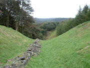
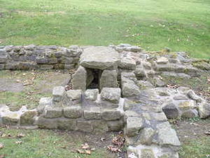
of the River KelvinRiver KelvinThe Kelvin rises on watershed of Scotland on the moor south east of the village of Banton, east of Kilsyth - . At almost 22 miles long, it initially flows south to Dullatur Bog where it falls into a man made trench and takes a ninety degree turn flowing west along the northern boundary of the bog... - Antonine WallAntonine WallThe Antonine Wall is a stone and turf fortification built by the Romans across what is now the Central Belt of Scotland, between the Firth of Forth and the Firth of Clyde. Representing the northernmost frontier barrier of the Roman Empire, it spanned approximately 39 miles and was about ten feet ...
- AuchenhowieAuchenhowieAuchenhowie is a small area in Glasgow, by Milngavie. It is best known as the location of Rangers F.C.'s Murray Park training facility.It is also home to Western Wildcats Hockey Club....
- AuchinairnAuchinairnAuchinairn is an area within East Dunbartonshire, Scotland, and shares its southern boundary with the City of Glasgow. The village Auchinairn possibly derives its name from the Gaelic "auch-an-earna" meaning "field of barley" or "auch-an-iarann" meaning “field of iron" .There were actually two...
- AuchinreochAuchinreochAuchinreoch is a village in East Dunbartonshire, Scotland....
- Auld Kirk Museum, KirkintillochKirkintillochKirkintilloch is a town and former burgh in East Dunbartonshire, Scotland. It lies on the Forth and Clyde Canal, about eight miles northeast of central Glasgow...
B
- BaldernockBaldernockBaldernock is a small parish in East Dunbartonshire , Scotland, ten miles to the north of Glasgow's city centre.-Geography:...
- Balgrochan
- Baljaffray
- BalmoreBalmoreBalmore is a hamlet in East Dunbartonshire, Scotland, located 1 km West of Torrance and 5 km East of Milngavie....
- Balmore Golf Club
- Bardowie
- BearsdenBearsdenBearsden ) is a town in East Dunbartonshire, Scotland. It lies on the northwestern fringe of Greater Glasgow, approximately from the City Centre, and is effectively a suburb, with housing development coinciding with the introduction of a railway line in 1863, and from where the town gets its name...
- Bearsden AcademyBearsden AcademyBearsden Academy is a non-denominational, state secondary school in Bearsden, a suburb of Glasgow, Scotland.-History:The school was founded in 1911, sharing a building at Bearsden Cross with Bearsden Primary School. This building is still in use as the current Bearsden Primary site. In 1958, the...
- Bearsden Golf Club
- BirdstonBirdstonBirdston is a village in East Dunbartonshire, Scotland....
- BishopbriggsBishopbriggsBishopbriggs is a town in East Dunbartonshire, Scotland. The area was once part of the historic parish of Cadder - originally lands granted by King William the Lion to the Bishop of Glasgow, Jocelin, in 1180. It was later part of the county of Lanarkshire and subsequently an independent burgh from...
- Bishopbriggs AcademyBishopbriggs AcademyBishopbriggs Academy is a secondary school in the town of Bishopbriggs, in the district of East Dunbartonshire. Bishopbriggs Academy is a non-denominational, co-educational, comprehensive school taking pupils from S1 to S6...
- Bishopbriggs Library
- Bishopbriggs Golf Club
- Blairskaith
- Boclair AcademyBoclair AcademyBoclair Academy is a co-educational comprehensive secondary school located in the Greater Glasgow suburb of Bearsden, East Dunbartonshire, Scotland. The school serves pupils aged 11 – 18 from Southern Bearsden and Torrance...
- BrookwoodBrookwoodBrookwood can refer to:*Brookwood, a shopping center and hospital in Homewood, Alabama*Brookwood, Alabama, a place in the Tuscaloosa metropolitan area*Brookwood, Surrey, a village in Surrey, England*Brookwood Cemetery, a place in England...
C
- CadderCadderCadder is a district of the town of Bishopbriggs, East Dunbartonshire, Scotland. Located 7 km north of Glasgow city centre, 0.5 km south of the River Kelvin, and approximately 1.5 km north-east of Bishopbriggs town centre, sited on the route of the Forth and Clyde Canal...
- Campsie FellsCampsie FellsThe Campsie Fells are a range of hills in central Scotland, stretching east to west, from Denny Muir to Dumgoyne, in Stirlingshire. . The highest point in the range is Earl's Seat which is 578 m high...
- Campsie Glen
- Campsie Golf Club
- Campsie Outdoors
- Cawder Golf Club
- Celtic F.C. training ground
- Clachan of CampsieClachan of CampsieClachan of Campsie or Campsie is a settlement now in the East Dunbartonshire area of Scotland. It was formerly part of the county of Stirlingshire...
- Clober Golf Club
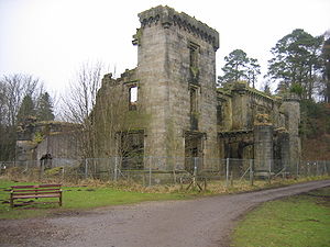
- Craigend CastleCraigend CastleCraigend Castle is a ruined country house, located to the north of Milngavie, in East Dunbartonshire, central Scotland.The lands of Craigend were part of the Barony of Mugdock in medieval times, but the estate was sold in the mid-17th century to the Smith family. John Smith was born at Craigend...
- CraigtonCraigtonFormerly farming land for the Township of Govan, Craigton is a residential suburb in the southwest of the Scottish city of Glasgow. It borders Cardonald, Govan and Bellahouston Park. It has a primary school, Craigton Primary School, a small industrial estate and a number of shops lining Paisley...
G
- The GadlochGadlochThe Gadloch is a fresh water loch situated at the edge of the town of Lenzie in East Dunbartonshire, Scotland....
, Lenzie - Glasgow Killermont Golf Club
- Glazert Water, a tributaryTributaryA tributary or affluent is a stream or river that flows into a main stem river or a lake. A tributary does not flow directly into a sea or ocean...
of the River KelvinRiver KelvinThe Kelvin rises on watershed of Scotland on the moor south east of the village of Banton, east of Kilsyth - . At almost 22 miles long, it initially flows south to Dullatur Bog where it falls into a man made trench and takes a ninety degree turn flowing west along the northern boundary of the bog...
H
- Hayston Golf Club
- Hilton Park Golf Club
- Huntershill HouseHuntershill HouseHuntershill House is an 18th-century building in Bishopbriggs, East Dunbartonshire, Scotland. It was built around 1765, designed by an unknown architect. From the 1780s it was the family home of the political reformer Thomas Muir, Younger of Huntershill...
- Huntershill VillageHuntershill VillageHuntershill Village is located opposite Huntershill House at the top of Crowhill Road in Bishopbriggs, East Dunbartonshire, Scotland. Over forty local businesses operate from the location. It was historically part of the Huntershill Estate, former residence of the political reformer Thomas Muir...
K
- Kilmardinny House arts centre
- KilmardinnyKilmardinnyKilmardinny is a loch in Bearsden, East Dunbartonshire, Scotland. The loch is renowned for coarse fishing and its abundance of perch and roach. Situated nearby is Kilmardinny House, which after being owned by a succession of Glaswegian merchants and the Glasgow MP Robert Dalglish was donated to the...
Loch - KirkintillochKirkintillochKirkintilloch is a town and former burgh in East Dunbartonshire, Scotland. It lies on the Forth and Clyde Canal, about eight miles northeast of central Glasgow...
- Kirkintilloch High SchoolKirkintilloch High SchoolKirkintilloch High School is a six year co-educational secondary school located in the Oxgang area of Kirkintilloch, East Dunbartonshire, Scotland.-School roll:...
- Kirkintilloch Golf Club
L
- LennoxtownLennoxtownLennoxtown is a town in East Dunbartonshire, Scotland at the foot of the Campsie Fells, which are just to the north.It is now part of the East Dunbartonshire council area but prior to 1975 was in the county of Stirling....
- LenzieLenzieLenzie is a small town by the Edinburgh and Glasgow Railway in the East Dunbartonshire council area of Scotland. It is about six miles north-east of Glasgow city centre and one mile south of Kirkintilloch. It has a population of about 10,000.-Name:...
- Lenzie AcademyLenzie AcademyLenzie Academy is a co-educational comprehensive secondary school located in Lenzie, East Dunbartonshire, Scotland. The catchment area covers the town of Lenzie, the village of Auchinloch and southern parts of Kirkintilloch.-Senior Management Team:...
- Lenzie Golf Club
- LillieLillieLillie is a British television serial made by London Weekend Television for ITV and broadcast in 1978.This period serial starred Francesca Annis in the title role of Lillie Langtry...
Art Gallery - Luggie WaterLuggie WaterAccording to the "Ordnance Gazetteer of Scotland:Luggie Water, a rivulet of Lanarkshire and the detached district of Dumbartonshire, flowing 10 7/8 miles westward and west-north-westward along the boundaries or through the interior of Cumbernauld, New Monkland, Cadder, and Kirkintilloch parishes,...
, a tributaryTributaryA tributary or affluent is a stream or river that flows into a main stem river or a lake. A tributary does not flow directly into a sea or ocean...
of the River KelvinRiver KelvinThe Kelvin rises on watershed of Scotland on the moor south east of the village of Banton, east of Kilsyth - . At almost 22 miles long, it initially flows south to Dullatur Bog where it falls into a man made trench and takes a ninety degree turn flowing west along the northern boundary of the bog...
M
- MilngavieMilngavieMilngavie , is a town in East Dunbartonshire, Scotland. It is on the Allander Water, at the northwestern edge of Greater Glasgow, and about from Glasgow city centre. It neighbours Bearsden....
- Milngavie water treatment worksMilngavie water treatment worksMilngavie water treatment works is the primary source of the water for the city of Glasgow in western Scotland. Part of the Victorian Loch Katrine water project, construction was started in 1855 and the works was opened by Queen Victoria in 1859, replacing the previous water supply sourced from...
- Milngavie Golf Club
- Milton of CampsieMilton of CampsieMilton of Campsie is a small village situated in East Dunbartonshire, Scotland roughly 10 miles north of Glasgow. Nestling at the foot of the Campsie Fells, it is neighboured by Kirkintilloch and Lennoxtown...
N
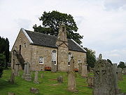
- New Kilpatrick Parish Church, BearsdenBearsdenBearsden ) is a town in East Dunbartonshire, Scotland. It lies on the northwestern fringe of Greater Glasgow, approximately from the City Centre, and is effectively a suburb, with housing development coinciding with the introduction of a railway line in 1863, and from where the town gets its name...
R
- Rangers F.C. training groundMurray ParkMurray Park is the training ground of association football team Rangers F.C. Located in Auchenhowie, Milngavie, on the outskirts of Glasgow.- History :...
- River KelvinRiver KelvinThe Kelvin rises on watershed of Scotland on the moor south east of the village of Banton, east of Kilsyth - . At almost 22 miles long, it initially flows south to Dullatur Bog where it falls into a man made trench and takes a ninety degree turn flowing west along the northern boundary of the bog...
, a tributaryTributaryA tributary or affluent is a stream or river that flows into a main stem river or a lake. A tributary does not flow directly into a sea or ocean...
of the River ClydeRiver ClydeThe River Clyde is a major river in Scotland. It is the ninth longest river in the United Kingdom, and the third longest in Scotland. Flowing through the major city of Glasgow, it was an important river for shipbuilding and trade in the British Empire....
W
- WatersideWaterside, East DunbartonshireWaterside is a small village situated in East Dunbartonshire, Scotland roughly 10 miles north-east of Glasgow, on the eastern outskirts of Kirkintilloch.-History:...
- WestertonWestertonWesterton may be:*Westerton, County Durham, England*Westerton, East Dunbartonshire, Scotland**Westerton railway station...
- West Highland WayWest Highland WayThe West Highland Way is a linear long distance footpath in Scotland, with the official status of Long Distance Route. It is 154.5km long, running from Milngavie north of Glasgow to Fort William in the Scottish Highlands, with an element of hill walking in the route...
- Windyhill Golf Club