
List of bridges on the National Register of Historic Places in Virginia
Encyclopedia
This is a list of bridge
s and tunnel
s on the National Register of Historic Places
in the U.S. state
of Virginia
.
Bridge
A bridge is a structure built to span physical obstacles such as a body of water, valley, or road, for the purpose of providing passage over the obstacle...
s and tunnel
Tunnel
A tunnel is an underground passageway, completely enclosed except for openings for egress, commonly at each end.A tunnel may be for foot or vehicular road traffic, for rail traffic, or for a canal. Some tunnels are aqueducts to supply water for consumption or for hydroelectric stations or are sewers...
s on the National Register of Historic Places
National Register of Historic Places
The National Register of Historic Places is the United States government's official list of districts, sites, buildings, structures, and objects deemed worthy of preservation...
in the U.S. state
U.S. state
A U.S. state is any one of the 50 federated states of the United States of America that share sovereignty with the federal government. Because of this shared sovereignty, an American is a citizen both of the federal entity and of his or her state of domicile. Four states use the official title of...
of Virginia
Virginia
The Commonwealth of Virginia , is a U.S. state on the Atlantic Coast of the Southern United States. Virginia is nicknamed the "Old Dominion" and sometimes the "Mother of Presidents" after the eight U.S. presidents born there...
.
| Name | Image | Built | Listed | Location | County | Type |
|---|---|---|---|---|---|---|
| Appomattox River Bridge | 1930 | 2005-07-27 | Appomattox Appomattox, Virginia Appomattox is a town in Appomattox County, Virginia, United States. The population was 1,761 at the 2000 census. It is the county seat of Appomattox County.Appomattox is part of the Lynchburg Metropolitan Statistical Area.-History:... 37°23′1"N 78°47′22"W |
Appomattox Appomattox County, Virginia Appomattox County is a county located in the Commonwealth of Virginia. As of 2010, the population was 14,973. Its county seat is Appomattox. For a long time, Appomattox was a prohibition or dry county... |
||
| Blackford Bridge | 2010-6-24 | Lebanon vicinity Lebanon, Virginia Lebanon is a town in Russell County, Virginia, United States. The population was 3,273 at the 2000 census. It is the county seat of Russell County.-Geography:Lebanon is located at .... |
Russell Russell County, Virginia As of the census of 2000, there were 30,308 people, 11,789 households, and 8,818 families residing in the county. The population density was 64 people per square mile . There were 13,191 housing units at an average density of 28 per square mile... |
|||
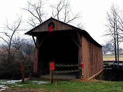
| Bob White Covered Bridge Bob White Covered Bridge The Bob White Covered Bridge, also known as the Lower Covered Bridge or Woolwine Covered Bridge, is a county owned wooden covered bridge that spans the Smith River in Patrick County, Virginia, United States. It is located on the old portion of Bob White Road off State Route 8 southeast of the... |
 |
1820, 1821 | 1973-05-22 | Woolwine Woolwine, Virginia Woolwine is an unincorporated community in northern Patrick County, Virginia, United States. The western terminus of State Route 40 is here, at State Route 8. The community lies in the Rocky Knob American Viticultural Area... 36°46′45"N 80°14′53"W |
Patrick Patrick County, Virginia Patrick County is a county located in the Commonwealth of Virginia. As of 2010, the population was 18,490. Its county seat is Stuart. It is located within both the rolling hills and valleys of the Piedmont Region of Virginia and mountainous Southwest Virginia.... |
Burr Arch |
| Bridge at Falling Creek | 1995-10-12 | Richmond Richmond, Virginia Richmond is the capital of the Commonwealth of Virginia, in the United States. It is an independent city and not part of any county. Richmond is the center of the Richmond Metropolitan Statistical Area and the Greater Richmond area... 37°26′22"N 77°26′22"W |
Chesterfield Chesterfield County, Virginia Chesterfield County is a county located in the Commonwealth of Virginia, a state of the United States. In 2010, its population was estimated to be 316,236. Chesterfield County is now the fourth-largest municipality in Virginia . Its county seat is Chesterfield... |
|||
| Broad Run Bridge and Tollhouse Broad Run Bridge and Tollhouse The Broad Run Bridge and Tollhouse were built for the Leesburg Turnpike Company in Loudoun County, Virginia. The stone bridge, built about 1820, was a permanent replacement for a series of wood bridges at the location, with at least three that had been washed away between 1771 and 1803. The bridge... |
1820 | 1970-04-17 | Sterling Sterling, Virginia Sterling, Virginia is a census-designated place in Loudoun County, Virginia. The population as of the 2010 Census was 27,822.It is located northwest of Herndon, east of Ashburn, and west of Great Falls, and includes part of Dulles International Airport and the former AOL corporate headquarters... 39°2′48"N 77°25′59"W |
Loudoun Loudoun County, Virginia Loudoun County is a county located in the Commonwealth of Virginia, and is part of the Washington Metropolitan Area. As of the 2010 U.S. Census, the county is estimated to be home to 312,311 people, an 84 percent increase over the 2000 figure of 169,599. That increase makes the county the fourth... |
Stone arch, collapsed since 1972 | |
| Cartersville Bridge Cartersville Bridge Cartersville Bridge is a historic bridge located near Cartersville, Virginia. It was constructed in 1822, and was added to the National Register of Historic Places in 1972.... |
1822, 1842, 1883 | 1972-09-14 | Cartersville 37°40′12"N 78°5′14"W |
Cumberland Cumberland County, Virginia As of the census of 2000, there were 9,017 people, 3,528 households, and 2,487 families residing in the county. The population density was 30 people per square mile . There were 4,085 housing units at an average density of 14 per square mile... |
Pratt truss | |
| Catoctin Creek Bridge Catoctin Creek Bridge The Catoctin Creek Bridge over Catoctin Creek in Virginia, is a nine-panel iron Pratt truss bridge, first erected about 1899. The bridge was fabricated by the Variety Iron Works of Cleveland, Ohio. It carries Virginia Route 673, also known as Featherbottom Road... |
1900, 1932 | 1974-06-25 | Waterford Waterford, Virginia Waterford is an unincorporated village in the Catoctin Valley of Loudoun County, Virginia, located along Catoctin Creek. Waterford is northwest of Washington, D.C., and northwest of Leesburg... 39°13′56"N 77°35′31"W |
Loudoun Loudoun County, Virginia Loudoun County is a county located in the Commonwealth of Virginia, and is part of the Washington Metropolitan Area. As of the 2010 U.S. Census, the county is estimated to be home to 312,311 people, an 84 percent increase over the 2000 figure of 169,599. That increase makes the county the fourth... |
Pratt Truss | |
| Clarkton Bridge | 1902 | 2007-01-26 | Nathalie Nathalie, Virginia Nathalie is a census-designated place in Halifax County, Virginia, United States, in the south central region of the state. The population as of the 2010 Census was 183. Located at , at an altitude of 554 feet , it lies along Road 603 north of the town of Halifax, the county seat of Halifax... 36°58′49"N 78°53′34"W |
Charlotte Charlotte County, Virginia As of the census of 2000, there were 12,472 people, 4,951 households, and 3,435 families residing in the county. The population density was 26 people per square mile . There were 5,734 housing units at an average density of 12 per square mile... |
Pratt through truss | |
| Crab Tree Run Truss Bridge | 2009-9-16 | McDowell |
Charlotte Highland County, Virginia As of the census of 2000, there were 2,536 people, 1,131 households, and 764 families residing in the county. The population density was 6 people per square mile . There were 1,822 housing units at an average density of 4 per square mile... |
truss | ||
| Gholson Bridge | 1884 | 1978-05-05 | Lawrenceville Lawrenceville, Virginia Lawrenceville is a town in Brunswick County, Virginia, United States. The population was 1,275 at the 2000 census. Located by the Meherrin River, it is the county seat of Brunswick County and home to historically black Saint Paul's College, founded in 1888 and affiliated with the Episcopal Church... 36°43′0"N 77°49′53"W |
Brunswick Brunswick County, Virginia As of the census of 2000, there were 18,419 people, 6,277 households, and 4,312 families residing in the county. The population density was 32 people per square mile . There were 7,541 housing units at an average density of 13 per square mile... |
Pratt Truss | |
| Goose Creek Stone Bridge Goose Creek Stone Bridge The Goose Creek Stone Bridge crosses Goose Creek in Loudoun County, Virginia. The long stone arch bridge spans the creek in four arches. Built about 1810, it is the largest stone turnpike bridge in northern Virginia, designed to carry the Ashby's Gap Turnpike across the creek. The turnpike was... |
1810 | 1974-10-09 | Atoka | Loudoun Loudoun County, Virginia Loudoun County is a county located in the Commonwealth of Virginia, and is part of the Washington Metropolitan Area. As of the 2010 U.S. Census, the county is estimated to be home to 312,311 people, an 84 percent increase over the 2000 figure of 169,599. That increase makes the county the fourth... |
||
| Goshen Land Company Bridge | 1890 | 1978-05-15 | Goshen Goshen, Virginia Goshen is a town in Rockbridge County, Virginia, United States. The population was 406 at the 2000 census. The town is known amongst the Boy Scouts of America for hosting Goshen Scout Reservation, one of the largest Boy Scout camps in America.... 37°59′7"N 79°29′39"W |
Rockbridge Rockbridge County, Virginia As of the census of 2000, there were 20,808 people, 8,486 households, and 6,075 families residing in the county. The population density was 35 people per square mile . There were 9,550 housing units at an average density of 16 per square mile... |
Through Pratt Truss Bridge | |
| Hibbs Bridge | 1829 | 2011-3-1 | Mountville vicinity Mountville, Virginia Mountville is an unincorporated community in the Loudoun Valley of Loudoun County, Virginia. The village is situated on Snickersville Turnpike halfway between Aldie and Philomont at the intersection of Mountville road.... 39°02′17"N 77°43′27"W |
Loudon | stone arch | |
| High Bridge High Bridge (Appomattox River) High Bridge is a historic former railroad bridge across the Appomattox River valley about east, or downstream, of the town of Farmville in Prince Edward County, Virginia... |
 |
2008-9-12 | Farmville Farmville, Virginia Farmville is a town in Prince Edward and Cumberland counties in the U.S. state of Virginia. The population was 6,845 at the 2000 census. It is the county seat of Prince Edward County.... vicinity 37°18′39.52"N 78°19′5.74"W |
Cumberland Cumberland County, Virginia As of the census of 2000, there were 9,017 people, 3,528 households, and 2,487 families residing in the county. The population density was 30 people per square mile . There were 4,085 housing units at an average density of 14 per square mile... |
||
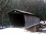
| Humpback Covered Bridge Humpback Covered Bridge The Humpback Covered Bridge located in the U.S. state of Virginia, is one of the few remaining covered bridges in the United States that was built higher in the middle than on either end; hence the name of "humpback". The bridge was built in 1857 and is also the oldest remaining covered bridge in... |
 |
1835 | 1969-10-01 | Callaghan Callaghan, Virginia Callaghan is a census-designated place in Alleghany County, Virginia, United States. The population as of the 2010 Census was 348.-Reference:*... 37°47′50"N 80°2′48"W |
Alleghany Alleghany County, Virginia As of the census of 2000, there were 12,926 people, 5,149 households, and 3,866 families residing in the county. The population density was 29 people per square mile . There were 5,812 housing units at an average density of 13 per square mile... |
|
| Jack's Creek Covered Bridge Jack's Creek Covered Bridge The Jack's Creek Covered Bridge, also known as the Upper Covered Bridge, is a county owned wooden covered bridge that spans the Smith River in Patrick County, Virginia, United States. It is located on Jack's Creek Road off State Route 8 just south of the community of Woolwine, about 11 miles ... |
 |
1914 | 1973-05-22 | Woolwine Woolwine, Virginia Woolwine is an unincorporated community in northern Patrick County, Virginia, United States. The western terminus of State Route 40 is here, at State Route 8. The community lies in the Rocky Knob American Viticultural Area... 36°45′51"N 80°16′25"W |
Patrick Patrick County, Virginia Patrick County is a county located in the Commonwealth of Virginia. As of 2010, the population was 18,490. Its county seat is Stuart. It is located within both the rolling hills and valleys of the Piedmont Region of Virginia and mountainous Southwest Virginia.... |
|
| Francis Scott Key Bridge | 1917, 1923, 1939 | 1996-03-01 | Arlington 38°54′8"N 77°4′13"W |
Arlington Arlington County, Virginia Arlington County is a county in the Commonwealth of Virginia. The land that became Arlington was originally donated by Virginia to the United States government to form part of the new federal capital district. On February 27, 1801, the United States Congress organized the area as a subdivision of... |
||
| Linville Creek Bridge | 1898 | 1978-04-15 | Broadway Broadway, Virginia Broadway is a town in Rockingham County, Virginia, United States. The population was 2,192 at the 2000 census. It is included in the Harrisonburg, Virginia Metropolitan Statistical Area.-Geography:Broadway is located at .... 38°36′22"N 78°48′13"W |
Rockingham Rockingham County, Virginia As of the census of 2000, there were 67,725 people, 25,355 households, and 18,889 families residing in the county. The population density was 80 people per square mile . There were 27,328 housing units at an average density of 32 per square mile... |
Hybrid Pratt-Warren Truss | |
| Meems Bottom Covered Bridge | 1893, 1894 | 1975-06-10 | Mt. Jackson 38°43′14"N 78°39′20"W |
Shenandoah Shenandoah County, Virginia As of the census of 2000, there were 35,075 people, 14,296 households, and 10,064 families residing in the county. The population density was 68 people per square mile . There were 16,709 housing units at an average density of 33 per square mile... |
Burr truss | |
| Natural Bridge Natural Bridge (Virginia) Natural Bridge, known as Natty B by locals, in the eponymous Rockbridge County, Virginia is a geological formation in which Cedar Creek has carved out a gorge in the mountainous limestone terrain, forming an arch 215 ft high with a span of 90 ft... |
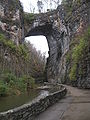 |
1774 | 1997-11-18 | Natural Bridge 37°37′39"N 79°32′43"W |
Rockbridge Rockbridge County, Virginia As of the census of 2000, there were 20,808 people, 8,486 households, and 6,075 families residing in the county. The population density was 35 people per square mile . There were 9,550 housing units at an average density of 16 per square mile... |
natural rock bridge |
| Nokesville Truss Bridge | 1882 | 1978-04-15 | Nokesville Nokesville, Virginia Nokesville is a census-designated place in Prince William County, Virginia, United States. The population was 1,236 at the 2000 census.-History:... 38°42′25"N 77°33′52"W |
Prince William Prince William County, Virginia -National protected areas:* Featherstone National Wildlife Refuge* Manassas National Battlefield Park* Occoquan Bay National Wildlife Refuge* Prince William Forest Park-Government and politics:... |
Single span Pratt truss | |
| Norfolk Southern Six Mile Bridge No. 58 | 1995-10-12 | Lynchburg Lynchburg, Virginia Lynchburg is an independent city in the Commonwealth of Virginia. The population was 75,568 as of 2010. Located in the foothills of the Blue Ridge Mountains along the banks of the James River, Lynchburg is known as the "City of Seven Hills" or "The Hill City." Lynchburg was the only major city in... |
Amherst Amherst County, Virginia As of the census of 2000, there were 31,894 people, 11,941 households, and 8,645 families residing in the county. The population density was 67 people per square mile . There were 12,958 housing units at an average density of 27 per square mile... , Campbell Campbell County, Virginia As of the census of 2000, there were 51,078 people, 20,639 households, and 14,694 families residing in the county. The population density was 101 people per square mile . There were 22,088 housing units at an average density of 44 per square mile... |
Pratt Truss | ||
| Oak Ridge Railroad Overpass | 1882 | 1978-04-15 | Shipman Shipman, Virginia Shipman is a census-designated place in Nelson County, Virginia, United States. The population as of the 2010 Census was 507.-References:*... 37°42′11"N 78°52′16"W |
Nelson Nelson County, Virginia As of the census of 2000, there were 14,445 people, 5,887 households, and 4,144 families residing in the county. The population density was 31 people per square mile . There were 8,554 housing units at an average density of 18 per square mile... |
Pratt truss | |
| Orange and Alexandria Railroad Bridge Piers | 1861, 1865 | 1989-08-08 | Manassas Park | Prince William Prince William County, Virginia -National protected areas:* Featherstone National Wildlife Refuge* Manassas National Battlefield Park* Occoquan Bay National Wildlife Refuge* Prince William Forest Park-Government and politics:... |
||
| Orange and Alexandria Railroad Hooff's Run Bridge Orange and Alexandria Railroad Hooff's Run Bridge The Orange and Alexandria Railroad Hooff's Run Bridge is a bridge in Alexandria, in the U.S. state of Virginia. It was added to the National Register of Historic Places in 2003.... |
 |
1856, 1872, by 1885 | 2003-08-07 | Alexandria Alexandria, Virginia Alexandria is an independent city in the Commonwealth of Virginia. As of 2009, the city had a total population of 139,966. Located along the Western bank of the Potomac River, Alexandria is approximately six miles south of downtown Washington, D.C.Like the rest of northern Virginia, as well as... 38°48′10"N 77°3′32"W |
Alexandria City Alexandria, Virginia Alexandria is an independent city in the Commonwealth of Virginia. As of 2009, the city had a total population of 139,966. Located along the Western bank of the Potomac River, Alexandria is approximately six miles south of downtown Washington, D.C.Like the rest of northern Virginia, as well as... |
Stone-arch railroad bridge |
| Phoenix Bridge | 1887 | 1975-06-10 | Eagle Rock Eagle Rock, Virginia Eagle Rock is an unincorporated community in Botetourt County, Virginia, United States, located on the James River between Iron Gate and Buchanan, Virginia.-Geography:Eagle Rock is located at . Its elevation is .-History:... 37°39′16"N 79°50′23"W |
Botetourt Botetourt County, Virginia As of the census of 2000, there were 30,496 people, 11,700 households, and 9,114 families residing in the county. The population density was 56 people per square mile . There were 12,571 housing units at an average density of 23 per square mile... |
Trapezoidal Whipple Truss | |
| Valley Railroad Stone Bridge | 1874 | 1974-11-19 | Jolivue Jolivue, Virginia Jolivue is a census-designated place in Augusta County, Virginia, United States. The population was 1,037 at the 2000 census. It is part of the Staunton–Waynesboro Micropolitan Statistical Area.-Geography:... 38°5′21"N 79°4′40"W |
Augusta Augusta County, Virginia As of the census of 2000, there were 65,615 people, 24,818 households, and 18,911 families residing in the county. The population density was 68 people per square mile . There were 26,738 housing units at an average density of 28 per square mile... |
||
| Virginian Railway Underpass | 1906 | 1989-11-13 | New Ellett 37°11′58"N 80°21′51"W |
Montgomery Montgomery County, Virginia As of the census of 2000, there were 83,629 people, 30,997 households, and 17,203 families residing in the county. The population density was 215 people per square mile . There were 32,527 housing units at an average density of 84 per square mile... |
Horseshoe-arch underpass | |
| Wolf Creek Bridge | 1927 | 2011-01-07 | Rocky Gap vicinity Rocky Gap, Virginia Rocky Gap is an unincorporated community that is located in Bland County in the U.S. state of Virginia. Rocky Gap's center sits at a high elevation of around 2,887 ft. In the year of 2009, there was an estimate that there were a total of 75 people living in Rocky Gap. Rocky Gap has one zip code... 37°14′24"N 81°5′56"W |
Bland Bland County, Virginia As of the census of 2000, there were 6,871 people, 2,568 households, and 1,908 families residing in the county. The population density was 19 people per square mile . There were 3,161 housing units at an average density of 9 per square mile... |
Truss | |
| Bridge over North Fork of Roanoke River | 1892 | removed 2001-03-19 |
Ironto | Montgomery Montgomery County, Virginia As of the census of 2000, there were 83,629 people, 30,997 households, and 17,203 families residing in the county. The population density was 215 people per square mile . There were 32,527 housing units at an average density of 84 per square mile... |
Through Pratt truss bridge | |
| Mansion Truss Bridge | 1903 | removed 2005-06-10 |
Mansion | Campbell Campbell County, Virginia As of the census of 2000, there were 51,078 people, 20,639 households, and 14,694 families residing in the county. The population density was 101 people per square mile . There were 22,088 housing units at an average density of 44 per square mile... |
Camelback through truss | |
| Springwood Truss Bridge | 1883, 1884 | removed 2001-03-19 |
Springwood Springwood, Virginia Springwood is an unincorporated community in Botetourt County, Virginia, United States.... |
Botetourt Botetourt County, Virginia As of the census of 2000, there were 30,496 people, 11,700 households, and 9,114 families residing in the county. The population density was 56 people per square mile . There were 12,571 housing units at an average density of 23 per square mile... |
Wooden Truss |