

List of bridges on the National Register of Historic Places in Missouri
Encyclopedia
This is a list of bridge
s and tunnel
s on the National Register of Historic Places
in the U.S. state
of Missouri
.
Bridge
A bridge is a structure built to span physical obstacles such as a body of water, valley, or road, for the purpose of providing passage over the obstacle...
s and tunnel
Tunnel
A tunnel is an underground passageway, completely enclosed except for openings for egress, commonly at each end.A tunnel may be for foot or vehicular road traffic, for rail traffic, or for a canal. Some tunnels are aqueducts to supply water for consumption or for hydroelectric stations or are sewers...
s on the National Register of Historic Places
National Register of Historic Places
The National Register of Historic Places is the United States government's official list of districts, sites, buildings, structures, and objects deemed worthy of preservation...
in the U.S. state
U.S. state
A U.S. state is any one of the 50 federated states of the United States of America that share sovereignty with the federal government. Because of this shared sovereignty, an American is a citizen both of the federal entity and of his or her state of domicile. Four states use the official title of...
of Missouri
Missouri
Missouri is a US state located in the Midwestern United States, bordered by Iowa, Illinois, Kentucky, Tennessee, Arkansas, Oklahoma, Kansas and Nebraska. With a 2010 population of 5,988,927, Missouri is the 18th most populous state in the nation and the fifth most populous in the Midwest. It...
.
| Name | Image | Built | Listed | Location | County | Type |
|---|---|---|---|---|---|---|
| Arrow Rock State Historic Site Bridge | 1985-03-04 | Arrow Rock Arrow Rock, Missouri Arrow Rock is a village in Saline County, Missouri, United States. The population was 79 as of the 2000 Census . The musical Tom Sawyer , based on the novel by Mark Twain, was filmed here. Arrow Rock Historic District has significant properties and the George Caleb Bingham House has been designated... 39°4′6"N 92°56′39"W |
Saline | |||
| Barretts Tunnels | 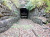 |
1851, 1853 | 1978-12-08 | Kirkwood Kirkwood, Missouri Kirkwood is an inner-ring suburb of St. Louis, located in St. Louis County, Missouri. As of the 2010 census, the city population was 27,540. Founded in 1853, the city is named for James Pugh Kirkwood, builder of the Pacific Railroad through that town. It was the first planned suburb located west... 38°34′21"N 90°27′18"W |
St. Louis St. Louis County, Missouri St. Louis County is a county located in the U.S. state of Missouri. Its county seat is Clayton. St. Louis County is part of the St. Louis Metro Area wherein the independent City of St. Louis and its suburbs in St. Louis County, as well as the surrounding counties in both Missouri and Illinois all... |
|
| Boeckman Bridge | 1926 | 1979-03-19 | St. Elizabeth St. Elizabeth, Missouri St. Elizabeth is a village in Miller County, Missouri, United States. The population was 336 at the 2010 census.-Geography:St. Elizabeth is located at .... 38°13′35"N 92°14′23"W |
Miller | ||
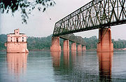
| Brownville Bridge |  |
1939 | 1993-06-17 | Phelps City Phelps City, Missouri Phelps City, Missouri is a location in Atchison County, Missouri. It is the closest Missouri community to Brownville Bridge, a Missouri River crossing that is listed on the National Register of Historic Places.-References:... 40°23′57"N 95°39′6"W |
Atchison Atchison County, Missouri Atchison County is a county located in the U.S. state of Missouri. As of 2010, the population was 5,685. Its county seat is Rock Port. The county was organized in 1845 and named for David Rice Atchison, U.S... |
|
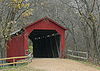
| Burfordville Covered Bridge Bollinger Mill State Historic Site The Bollinger Mill State Historic Site is located in Burfordville, in Cape Girardeau County, Missouri. The park was established in 1967 around a mill and covered bridge that pre-date the American Civil War... |
.jpg) |
1858 | 1970-05-19 | Burfordville Burfordville, Missouri Burfordville is an unincorporated community in western Cape Girardeau County, Missouri, United States. It is located five miles west of Jackson on Route 34. Bollinger Mill State Historic Site is located here, on the banks of the Whitewater River.... 37°22′2"N 89°48′9"W |
Cape Girardeau Cape Girardeau County, Missouri Cape Girardeau County is a county located in Southeast Missouri in the United States. As of the 2010 U.S. Census, the county's population was 75,764. While the largest city in the county is Cape Girardeau, the county seat is actually Jackson, which was the first city named in honor of President... |
Howe Truss |
| Chain of Rocks Bridge Chain of Rocks Bridge The Chain of Rocks Bridge spans the Mississippi River on the north edge of St. Louis, Missouri. The eastern end of the bridge is on Chouteau Island, , while the western end is on the Missouri shoreline.... |
 |
1929, 1936 | 2006-12-01 | St. Louis St. Louis, Missouri St. Louis is an independent city on the eastern border of Missouri, United States. With a population of 319,294, it was the 58th-largest U.S. city at the 2010 U.S. Census. The Greater St... |
St. Louis City St. Louis, Missouri St. Louis is an independent city on the eastern border of Missouri, United States. With a population of 319,294, it was the 58th-largest U.S. city at the 2010 U.S. Census. The Greater St... |
Warrant Truss |
| Crowder State Park Vehicle Bridge | 1985-03-04 | Trenton Trenton, Missouri Trenton is a city in Grundy County, Missouri, United States. The population was 6,006 in 2009. The population according to the 2000 census was 6,216, indicating a 3.4% decrease in population from 2000 to 2009. It is the county seat of Grundy County... 40°5′31"N 93°39′51"W |
Grundy | Rustic arch | ||
| Eads Bridge Eads Bridge The Eads Bridge is a combined road and railway bridge over the Mississippi River at St. Louis, connecting St. Louis and East St. Louis, Illinois.... |
1867, 1874 | 1966-10-15 | St. Louis St. Louis, Missouri St. Louis is an independent city on the eastern border of Missouri, United States. With a population of 319,294, it was the 58th-largest U.S. city at the 2010 U.S. Census. The Greater St... 38°37′45"N 90°11′8"W |
St. Louis City St. Louis, Missouri St. Louis is an independent city on the eastern border of Missouri, United States. With a population of 319,294, it was the 58th-largest U.S. city at the 2010 U.S. Census. The Greater St... |
Cantilever deck arch | |
| Hargrove Pivot Bridge | 1917 | 1985-10-15 | Poplar Bluff Poplar Bluff, Missouri Poplar Bluff is a city in Butler County located in Southeast Missouri in the United States. It is the county seat of Butler County and is known as "The Gateway to the Ozarks" among other names. As of the 2000 U.S... 36°38′50"N 90°18′0"W |
Butler Butler County, Missouri Butler County is a county located in the southeast Ozark Foothills Region in Southeast Missouri in the United States. As of the 2010 U.S. Census, the county's population was 42,794. The largest city and county seat is Poplar Bluff. The county was officially organized from Wayne County on February... |
Wichert and Warren Truss | |
| Jefferson Street Footbridge |  |
2003-09-02 | Springfield Springfield, Missouri Springfield is the third largest city in the U.S. state of Missouri and the county seat of Greene County. According to the 2010 census data, the population was 159,498, an increase of 5.2% since the 2000 census. The Springfield Metropolitan Area, population 436,712, includes the counties of... 37°13′58"N 93°17′21"W |
Greene Greene County, Missouri Greene County is a county located in Southwest Missouri. As of 2010, the population was 275,174 making it the fourth most populated county in Missouri. Its county seat is Springfield... |
Cantilever Through Truss | |
| Locust Creek Covered Bridge Locust Creek Covered Bridge (Missouri) The Locust Creek Covered Bridge, also called the Linn County Bridge, is a covered bridge located in Linn County, Missouri about west of Laclede and is actually beside Locust Creek in Meadville, Missouri. It is the longest of four surviving covered bridges in Missouri... |
1868 | 1970-05-19 | Laclede Laclede, Missouri Laclede is a city in Linn County, Missouri, United States. The population was 415 at the 2000 census.-Geography:Laclede is located at .... 39°47′30"N 93°14′3"W |
Linn Linn County, Missouri As of the census of 2000, there were 13,754 people, 5,697 households, and 3,760 families residing in the county. The population density was 22 people per square mile . There were 6,554 housing units at an average density of 11 per square mile... |
||
| Meramec River U.S. 66 Bridge - J421 | 2009-9-16 | Eureka Eureka, Missouri Eureka is a city located in St. Louis County, Missouri, United States, between St. Louis and Pacific, Missouri, along Interstate 44. As of the 2010 census, the city had a total population of 10,189. The city is west of the former site of Times Beach, the site of dioxin contamination discovered in... 38°30′20"N 90°35′31.19"W |
St. Louis St. Louis County, Missouri St. Louis County is a county located in the U.S. state of Missouri. Its county seat is Clayton. St. Louis County is part of the St. Louis Metro Area wherein the independent City of St. Louis and its suburbs in St. Louis County, as well as the surrounding counties in both Missouri and Illinois all... |
Warren deck truss | ||
| Montserrat Recreation Demonstration Area Bridge | 1937 | 1985-03-04 | Knob Noster Knob Noster, Missouri Knob Noster is a city in Johnson County, Missouri, United States. The population was 2,462 at the 2000 census. It is located adjacent to Whiteman Air Force Base. Knob Noster State Park is nearby.-History:... 38°45′13"N 93°34′36"W |
Johnson Johnson County, Missouri Johnson County is a county located in the U.S. state of Missouri. As of 2010, the population was 52,595. Its county seat is Warrensburg. The county was formed 13 December 1834 from Lafayette County and was named for Vice President Richard M... |
||
| Papinville Marais des Cygnes River Bridge | 1884 | 2002-10-22 | Papinville 38°4′6"N 94°13′54"W |
Bates Bates County, Missouri Bates County is a county located in the U.S. state of Missouri. As of 2000, the population is 16,653. Its county seat is Butler. The county was organized in 1833 and named after Frederick Bates, the second governor of Missouri.... |
Pinned Pratt through truss | |
| Pin Oak Hollow Bridge | 1934, 1938 | 1985-09-13 | Pin Oak Hollow 38°6′50"N 92°36′43"W |
Camden Camden County, Missouri Camden County is a county located in the U.S. state of Missouri. As of 2000, the population was 37,051. Its county seat is Camdenton. The county was organized in 1841 as Kinderhook County and renamed in 1843, for Charles Pratt, 1st Earl Camden, Chancellor of England, and leader of the Whig... |
Single-arch | |
| Powell Bridge | 2011-4-20 | Powell vicinity Powell, Missouri Powell is an unincorporated community in eastern McDonald County, Missouri, United States. It is located on Missouri Supplemental Route E about ten miles east of Pineville. It is located on Big Sugar Creek in a scenic area. The community includes some homes, a couple of businesses, and a post... 36°36′57"N 94°10′56"W |
McDonald McDonald County, Missouri McDonald County is a county located in Southwest Missouri in the United States of America. As of the 2010 U.S. Census, the population was 23,083. Its county seat is Pineville... |
|||
| Rulo Bridge |  |
1938, 1939 | 1993-01-04 | Fortescue Fortescue, Missouri Fortescue is a village in Holt County, Missouri, United States. The population was 51 at the 2000 census, at which time it was a town.-Geography:Fortescue is located at .... 40°3′14"N 95°25′14"W |
Holt Holt County, Missouri Holt County is a county located in the U.S. state of Missouri. The county is in the northwest part of the state. As of 2010, the population was 4,912. Its county seat is Oregon. The county was organized in 1841 and is named after the Missouri state legislator Dr... |
Pennsylvania through truss |
| Sandy Creek Covered Bridge Sandy Creek Covered Bridge State Historic Site Sandy Creek Covered Bridge State Historic Site in Jefferson County, Missouri, is administered by the Missouri Department of Natural Resources' Division of State Parks to preserve the Sandy Creek Covered Bridge. The bridge is one of four remaining covered bridges in Missouri, which once numbered... |
 |
1872 | 1970-07-08 | Hillsboro Hillsboro, Missouri Hillsboro is a city in Jefferson County, Missouri, United States. The estimated population as of 2008 is 2,062. The population was 1,675 at the 2000 census. It is the county seat of Jefferson County.- Origin of name :... 38°17′38"N 90°31′5"W |
Jefferson Jefferson County, Missouri Jefferson County is a county located in East Central Missouri in the United States. The county was included as the mean center of U.S. population in 1980. It is the sixth most-populous county in Missouri. Census 2010 put the population at 218,733 Its county seat is Hillsboro. The county was... |
Howe Truss |
| Swan Creek Bridge | 1914, 1932 | 1983-09-08 | Forsyth Forsyth, Missouri Forsyth is a city in Taney County, Missouri, United States. The population was 1,686 at the 2000 census. It is the county seat of Taney County. The town is part of the Branson, Missouri Micropolitan Statistical Area-Geography:... 36°42′2"N 93°5′8"W |
Taney Taney County, Missouri Taney County is a county located in Southwest Missouri in the United States. As of the 2000 U.S. Census, the county's population was 39,703. In the 2010 census the counties population was 51,675 Its county seat is Forsyth.... |
||
| Union Covered Bridge Union Covered Bridge State Historic Site Union Covered Bridge State Historic Site in Monroe County, Missouri, is maintained by the Missouri Department of Natural Resources as a state historic site to preserve the Union covered bridge. The bridge was built in 1871 across the Elk Fork of the Salt River as a link in the Paris-to-Fayette... |
1870, 1871 | 1970-06-15 | Paris Paris, Missouri Paris is a city in Monroe County, Missouri, United States. The population was 1,529 at the 2000 census. It is the county seat of Monroe County.-Geography:Paris is located at... 39°25′58"N 92°6′9"W |
Monroe | ||
| Upper Bridge | 1928 | 1999-09-17 | Warsaw Warsaw, Missouri Warsaw is a city located in Benton County, Missouri. As of the 2000 census, the city had a total population of 2,070. It is the county seat of Benton County. As of 2005, its estimated population was 2,268.-State and U.S. records:... 38°14′39"N 93°23′16"W |
Benton | ||
| Waddell "A" Truss Bridge | 1898, 1980, 1987 | 1991-01-25 | Parkville Parkville, Missouri Parkville is a city in Platte County, Missouri, United States. The population was 4,059 at the 2000 census. Parkville is known for its antique shops, art galleries, and historic downtown. The city is home to Park University and English Landing Park.... 39°11′9"N 94°40′55"W |
Platte Platte County, Missouri As of the census of 2000, there were 73,781 people, 29,278 households, and 20,231 families residing in the county. The population density was 176 people per square mile . There were 30,902 housing units at an average density of 74 per square mile... |
Waddell "A" truss | |
| Waverly Bridge Waverly Bridge (Missouri) The Waverly Bridge is a bridge at Waverly, Missouri, carrying U.S. Route 24 and U.S. Route 65 over the Missouri River between Carroll County and Lafayette County.... |
||||||
| Windsor Harbor Road Bridge Windsor Harbor Road Bridge Windsor Harbor Road Bridge - a sign outside this bridge proclaims:WINDSOR HARBOR ROAD BRIDGECarondelt, Missouri, 1874-1928Moved to this site 1930... |
 |
1874, 1875 | 1983-09-08 | Kimmswick Kimmswick, Missouri Kimmswick is a city in Jefferson County, Missouri, United States. The estimated population in 2007 was 102. It was 94 at the 2000 census.-Geography:Kimmswick is a fourth class city located at... 38°21′50"N 90°21′44"W |
Jefferson Jefferson County, Missouri Jefferson County is a county located in East Central Missouri in the United States. The county was included as the mean center of U.S. population in 1980. It is the sixth most-populous county in Missouri. Census 2010 put the population at 218,733 Its county seat is Hillsboro. The county was... |
|
| Y Bridge Y-Bridge (Galena, Missouri) The Y-Bridge is an old highway bridge over the James River located at Galena, Missouri and opened in 1927. It is named the Y-Bridge because it is shaped like the letter "Y". The bridge is such that , one could then either head north or south upon reaching the east end, where the highway was... |
 |
1926, 1927 | 1991-05-23 | Galena Galena, Missouri Galena is a city in Stone County, Missouri, United States. The population was 451 at the 2000 census. It is the county seat of Stone County. Galena is part of the Branson, Missouri Micropolitan Statistical Area.-Geography:... 36°48′18"N 93°27′41"W |
Stone Stone County, Missouri Stone County is a county located in Southwest Missouri in the United States. As of the 2010 U.S. Census, the county's population was 32,202. Its county seat is Galena... |
Open spandrel arch Y bridge |