
List of West Virginia state parks
Encyclopedia
State park
State parks are parks or other protected areas managed at the federated state level within those nations which use "state" as a political subdivision. State parks are typically established by a state to preserve a location on account of its natural beauty, historic interest, or recreational...
system in West Virginia
West Virginia
West Virginia is a state in the Appalachian and Southeastern regions of the United States, bordered by Virginia to the southeast, Kentucky to the southwest, Ohio to the northwest, Pennsylvania to the northeast and Maryland to the east...
has grown to 36 parks and 2 rail trails since the dedication of the Droop Mountain Battlefield
Droop Mountain Battlefield State Park
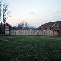
Droop Mountain Battlefield State Park is a state park located on Droop Mountain in Pocahontas County, West Virginia. Droop Mountain was the site of the last major conflict of the American Civil War in West Virginia. A private in the U.S. Army at the Battle of Droop Mountain, John D...
as the first state park on July 4, 1928. The state park system is managed as a component of the West Virginia Division of Natural Resources
West Virginia Division of Natural Resources
The West Virginia Division of Natural Resources is an agency of the government of the U.S. state of West Virginia. While formerly known as the cabinet-level Department of Natural Resources, it is now part of the West Virginia Department of Commerce...
.
West Virginia State Parks
Park |
County |
Area |
Accommodations |
Dining |
Swimming |
Gift |
Golfing |
||||
|---|---|---|---|---|---|---|---|---|---|---|---|
Acres |
Hectares |
Lodge |
Cabins |
Camping |
Shop |
||||||
 |
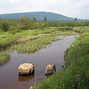
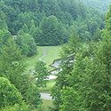
Audra Audra State Park Audra State Park is a West Virginia state park located on in southwestern Barbour County. It was established around the remnants of an early nineteenth century gristmill and the tiny community of Audra. A gristmill spillway is still visible in the river.... |
Barbour Barbour County, West Virginia As of the census of 2000, there are 15,557 people, 6,123 households, and 4,365 families residing in the county. The population density is 46 people per square mile . There are 7,348 housing units at an average density of 22 per square mile... |
355 | 144 |  |
|
|||||
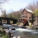 |
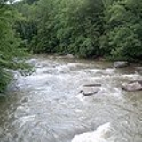
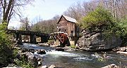
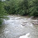
Babcock Babcock State Park Babcock State Park is a state park located along the New River Gorge on wooded in Fayette County, West Virginia. Located near the park headquarters, the Glade Creek Grist Mill is among the most photographed tourist sites in the state of West Virginia. It was named in honor of Edward V... |
Fayette Fayette County, West Virginia As of the census of 2000, there were 47,579 people, 18,945 households, and 13,128 families residing in the county. The population density was 72 people per square mile . There were 21,616 housing units at an average density of 33 per square mile... |
4,127 | 1,670 | |
|
|
|
|||
 |
Beartown Beartown State Park Beartown State Park is a state park located on the eastern summit of Droop Mountain, southwest of Hillsboro, West Virginia, in northern Greenbrier County, West Virginia . The land was purchased in 1970 with funds from the Nature Conservancy and a donation from Mrs. Edwin G... |
Greenbrier Greenbrier County, West Virginia As of the census of 2000, there were 34,453 people, 14,571 households, and 9,922 families residing in the county. The population density was 34 people per square mile . There were 17,644 housing units at an average density of 17 per square mile... |
110 | 45 | |||||||
 Beech Fork State Park Beech Fork State Park is a state park located in Cabell County and Wayne County, West Virginia. The park is located on the tailwater shores of Beech Fork Lake, a flood control impoundment of the U.S. Army Corps of Engineers on the Beech Fork of Twelvepole Creek... |
Wayne Wayne County, West Virginia As of the census of 2000, there were 42,903 people, 17,239 households, and 12,653 families residing in the county. The population density was 85 people per square mile . There were 19,107 housing units at an average density of 38 per square mile... |
3,860 | 1,562 | |
|
|
|||||
| Cabell Cabell County, West Virginia As of the census of 2000, there were 96,784 people, 41,180 households, and 25,490 families residing in the county. The population density was 344 people per square mile . There were 45,615 housing units at an average density of 162 per square mile... |
|||||||||||
 |
Berkeley Springs Berkeley Springs State Park Berkeley Springs State Park is a state park located in the center of Berkeley Springs, West Virginia. The centerpieces of this park are the spa facilities. These waters are currently and historically billed as having medicinal or restorative powers, generally taken internally for digestive... |
Morgan Morgan County, West Virginia Morgan County is a county located in the U.S. state of West Virginia. As of 2010, it's population was 17,541. Its county seat is Berkeley Springs. The county is one of three in Hagerstown-Martinsburg, MD-WV Metropolitan Statistical Area... |
7 | 3 | |||||||
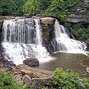 |
Blackwater Falls Blackwater Falls State Park Blackwater Falls State Park is located in the Allegheny Mountains of Tucker County, West Virginia, USA. The centerpiece of the Park is Blackwater Falls, a cascade where the Blackwater River leaves its leisurely course in Canaan Valley and enters rugged Blackwater Canyon... |
Tucker Tucker County, West Virginia As of the census of 2000, there were 7,321 people, 3,052 households, and 2,121 families residing in the county. The population density was 18 people per square mile . There were 4,634 housing units at an average density of 11 per square mile... |
2,358 | 954 | |
|
|
|
|
||
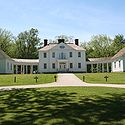 |
Blennerhassett Island Historical Blennerhassett Island Historical State Park Blennerhassett Island Historical State Park is a state park located on Blennerhassett Island, a small island in the Ohio River, located in Wood County, West Virginia, USA. The property was the site of a Palladian mansion owned by Harman Blennerhassett, a participant in some of the alleged... |
Wood Wood County, West Virginia As of the census of 2000, there were 87,986 people, 36,275 households, and 24,884 families residing in the county. The population density was 240 people per square mile . There were 39,785 housing units at an average density of 108 per square mile... |
511 | 206 | |
||||||
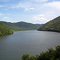 |
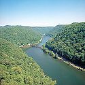
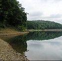
Bluestone Bluestone State Park Bluestone State Park is a state park in Summers County, West Virginia. The park is located along the western shores of Bluestone Lake, an impoundment of the New River built and managed by the U.S. Army Corps of Engineers... |
Summers Summers County, West Virginia Summers County is a county located in the U.S. state of West Virginia. As of the 2010 census, the population was 13,927. Its county seat is Hinton. Summers County was created by an act of the West Virginia General Assembly on February 27, 1871 from parts of Fayette, Greenbrier, Mercer and Monroe... |
2,154 | 872 | |
|
|
||||
 |
Cacapon Resort Cacapon Resort State Park Opened in 1933, the Cacapon Resort State Park is located on the eastern slopes of Cacapon Mountain in Morgan County, West Virginia. Panorama Overlook, at the southern end of the park and above sea level, is the highest point in the park and in Morgan County.- Features :* 48-room Lodge* 12-room... |
Morgan Morgan County, West Virginia Morgan County is a county located in the U.S. state of West Virginia. As of 2010, it's population was 17,541. Its county seat is Berkeley Springs. The county is one of three in Hagerstown-Martinsburg, MD-WV Metropolitan Statistical Area... |
6,115 | 2,430 | |
|
|
|
|
|
|
 |
Camp Creek Camp Creek State Park Camp Creek State Park was created in 1987 by dividing the area from Camp Creek State Forest. Camp Creek State Park is located about two miles from the Camp Creek Exit of I-77 in Mercer County, West Virginia.- Features :* 3 campgrounds... |
Mercer Mercer County, West Virginia -External links:* * * * * * *... |
550 | 223 | |
||||||
 |
Canaan Valley Resort Canaan Valley Resort State Park Canaan Valley Resort State Park is a state park within Canaan Valley, Tucker County, West Virginia. Located in the highest valley east of the Mississippi River, the park contains the second-largest inland wetland area in the United States... |
Tucker Tucker County, West Virginia As of the census of 2000, there were 7,321 people, 3,052 households, and 2,121 families residing in the county. The population density was 18 people per square mile . There were 4,634 housing units at an average density of 11 per square mile... |
6,300 | 2,550 | |
|
|
||||
 |
Carnifex Ferry Battlefield Carnifex Ferry Battlefield State Park Carnifex Ferry Battlefield State Park is an American Civil War battle site that commemorates the Battle of Carnifex Ferry. It is located on the rim of the Gauley River Canyon near Summersville, a town in Nicholas County, West Virginia. The park features Patterson House Museum, three views of the... |
Nicholas | 156 | 63 | |||||||
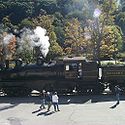 |
Cass Scenic Railroad Cass Scenic Railroad State Park Cass Scenic Railroad State Park is a State Park located in Cass, Pocahontas County, West Virginia.It consists of the Cass Scenic Railroad, an long heritage railroad that is owned by the state of West Virginia... |
Pocahontas Pocahontas County, West Virginia As of the census of 2000, there were 9,131 people, 835 households, and 527 families residing in the county. The population density was 10 people per square mile . There were 7,594 housing units at an average density of 8 per square mile... |
940 (1) | 380 (1) | |
|
|
||||
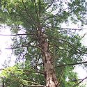 |
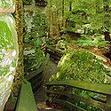
Cathedral Cathedral State Park Cathedral State Park is the largest virgin timber tract remaining in West Virginia. Located on about one mile east of the town of Aurora, Cathedral is a mixed forest of predominantly eastern hemlock.... |
Preston Preston County, West Virginia As of the census of 2000, there were 29,334 people, 11,544 households, and 8,357 families residing in the county. The population density was 45 people per square mile . There were 13,444 housing units at an average density of 21 per square mile... |
132 | 53 | |||||||
 |
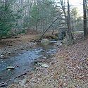
Cedar Creek Cedar Creek State Park Cedar Creek State Park is sited on along Cedar Creek in Gilmer County, West Virginia, located about south of Glenville and about west of Burnsville/Glenville exit of I-79... |
Gilmer Gilmer County, West Virginia As of the census of 2000, there were 7,160 people, 2,768 households, and 1,862 families residing in the county. The population density was 21 people per square mile . There were 3,621 housing units at an average density of 11 per square mile... |
2,588 | 1,047 | |
|
|
||||
| Chief Logan Chief Logan State Park Chief Logan State Park is located on about north of Logan in Logan County, West Virginia, United States. The park, the town and the county were all named after Chief Logan, a Mingo Native American leader who lived in the region before the American Revolutionary War... |
Logan Logan County, West Virginia As of the census of 2000, there were 37,710 people, 14,880 households, and 10,936 families residing in the county. The population density was 83 people per square mile . There were 16,807 housing units at an average density of 37 per square mile... |
3,988 | 1,614 | |
|
|
|
|
|||
 |
Droop Mountain Battlefield Droop Mountain Battlefield State Park Droop Mountain Battlefield State Park is a state park located on Droop Mountain in Pocahontas County, West Virginia. Droop Mountain was the site of the last major conflict of the American Civil War in West Virginia. A private in the U.S. Army at the Battle of Droop Mountain, John D... |
Pocahontas Pocahontas County, West Virginia As of the census of 2000, there were 9,131 people, 835 households, and 527 families residing in the county. The population density was 10 people per square mile . There were 7,594 housing units at an average density of 8 per square mile... |
287 | 116 | |||||||
 |
Fairfax Stone Fairfax Stone Fairfax Stone Historical Monument State Park is a West Virginia state park commemorating the Fairfax Stone, a surveyor's marker and boundary stone at the source of the North Branch of the Potomac River in West Virginia... |
Tucker Tucker County, West Virginia As of the census of 2000, there were 7,321 people, 3,052 households, and 2,121 families residing in the county. The population density was 18 people per square mile . There were 4,634 housing units at an average density of 11 per square mile... |
4 | 2 | |||||||
| Preston Preston County, West Virginia As of the census of 2000, there were 29,334 people, 11,544 households, and 8,357 families residing in the county. The population density was 45 people per square mile . There were 13,444 housing units at an average density of 21 per square mile... |
|||||||||||
 |
Greenbrier River Trail Greenbrier River Trail The Greenbrier River Trail is a rail trail operated by West Virginia State Parks. The trail is a long former railroad, now used for hiking, bicycling, ski-touring, horseback-riding, and wheel-chair use. The trail passes through numerous small towns and traverses 35 bridges and 2 tunnels as it... |
Greenbrier Greenbrier County, West Virginia As of the census of 2000, there were 34,453 people, 14,571 households, and 9,922 families residing in the county. The population density was 34 people per square mile . There were 17,644 housing units at an average density of 17 per square mile... |
(2) | (2) | |||||||
| Pocahontas Pocahontas County, West Virginia As of the census of 2000, there were 9,131 people, 835 households, and 527 families residing in the county. The population density was 10 people per square mile . There were 7,594 housing units at an average density of 8 per square mile... |
|||||||||||
 |
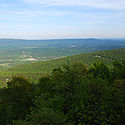
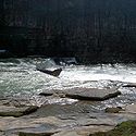
Hawks Nest Hawks Nest State Park Hawks Nest State Park is located on in Fayette County near Ansted, West Virginia. The park's clifftop overlook along U.S. Route 60 provides a scenic vista of the New River, some 750 feet below. The hydro-electric project tunnel that passes underneath nearby Gauley Mountain was the scene of the... |
Fayette Fayette County, West Virginia As of the census of 2000, there were 47,579 people, 18,945 households, and 13,128 families residing in the county. The population density was 72 people per square mile . There were 21,616 housing units at an average density of 33 per square mile... |
370 | 150 | |
|
|
||||
 |
Holly River Holly River State Park Holly River State Park is located in Webster County, West Virginia, USA, approximately north of Webster Springs. It is the second largest park in the West Virginia state park system with a total of... |
Webster | 8,294 | 3,356 | |
|
|
|
|
||
 |
Little Beaver Little Beaver State Park Little Beaver State Park is state park in Raleigh County, West Virginia. It is located near Beckley, West Virginia, about south of I-64 at Grandview Road, exit 129A... |
Raleigh Raleigh County, West Virginia As of the census of 2000, there were 79,220 people, 31,793 households, and 22,096 families residing in the county. The population density was 130 people per square mile . There were 35,678 housing units at an average density of 59 per square mile... |
562 | 227 | |
|
|||||
 |
Lost River Lost River State Park Lost River State Park is a state park located in Hardy County, West Virginia near the community of Mathias. The park encompasses managed by the West Virginia Division of Natural Resources. Despite the name of the park, it actually does not abut the Lost River; it actually lies about west of the... |
Hardy Hardy County, West Virginia As of the census of 2000, there were 12,669 people, 5,204 households, and 3,564 families residing in the county. The population density was 22 people per square mile . There were 7,115 housing units at an average density of 12 per square mile... |
3,712 | 1,502 | |
||||||
 |
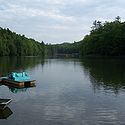
Moncove Lake Moncove Lake State Park Moncove Lake State Park was created in 1990 by setting aside of the Moncove Lake Wildlife Management Area to be operated as a state park. The park is located near Union in Monroe County, West Virginia... |
Monroe Monroe County, West Virginia As of the census of 2000, there were 14,583 people, 5,447 households, and 3,883 families residing in the county. The population density was 31 people per square mile . There were 7,267 housing units at an average density of 15 per square mile... |
896 | 363 | |
|
|||||
 |
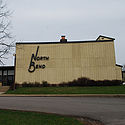
North Bend Rail Trail North Bend Rail Trail The North Bend Rail Trail is a rail trail in north-central and western West Virginia in the United States. It is operated by West Virginia State Parks and is part of the American Discovery Trail.... |
Doddridge Doddridge County, West Virginia As of the census of 2000, there were 7,403 people, 2,845 households, and 2,102 families residing in the county. The population density was 23 people per square mile . There were 3,661 housing units at an average density of 11 per square mile... |
(3) | (3) | |||||||
| Harrison Harrison County, West Virginia As of the census of 2000, there were 68,652 people, 27,867 households, and 19,088 families residing in the county. The population density was 165 people per square mile . There were 31,112 housing units at an average density of 75 per square mile... |
|||||||||||
| Ritchie Ritchie County, West Virginia As of the census of 2000, there were 10,343 people, 4,184 households, and 2,999 families residing in the county. The population density was 23 people per square mile . There were 5,513 housing units at an average density of 12 per square mile... |
|||||||||||
| Wood Wood County, West Virginia As of the census of 2000, there were 87,986 people, 36,275 households, and 24,884 families residing in the county. The population density was 240 people per square mile . There were 39,785 housing units at an average density of 108 per square mile... |
|||||||||||
 |
North Bend North Bend State Park North Bend State Park sits on along the North Fork of the Hughes River in Ritchie County near Cairo, West Virginia. The park is named after the sharp bend in the river that the formed three sides of the original park boundary. The North Bend Rail Trail, a 72-mile hiking and biking corridor, is... |
Ritchie Ritchie County, West Virginia As of the census of 2000, there were 10,343 people, 4,184 households, and 2,999 families residing in the county. The population density was 23 people per square mile . There were 5,513 housing units at an average density of 12 per square mile... |
2,459 | 995 | |
|
|
|
|
|
|
 |
Pinnacle Rock Pinnacle Rock State Park Pinnacle Rock State Park is a day use facility in Mercer County, West Virginia. The park surrounds Pinnacle Rock, a sandstone formation that rises to 3,100-ft elevation.-Features:* Pinnacle Rock* Jimmy Lewis Lake... |
Mercer Mercer County, West Virginia -External links:* * * * * * *... |
374 | 141 | |||||||
 |
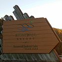
Pipestem Resort Pipestem Resort State Park Pipestem Resort State Park is a state park located in southern West Virginia, on the border between Mercer and Summers counties. The park was built with grants provided by the Area Redevelopment Administration of the U.S. Department of Commerce under the administration of President John F. Kennedy... |
Mercer Mercer County, West Virginia -External links:* * * * * * *... |
4,050 | 1,639 | |
|
|
|
|
|
|
| Summers Summers County, West Virginia Summers County is a county located in the U.S. state of West Virginia. As of the 2010 census, the population was 13,927. Its county seat is Hinton. Summers County was created by an act of the West Virginia General Assembly on February 27, 1871 from parts of Fayette, Greenbrier, Mercer and Monroe... |
|||||||||||
 |
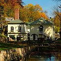
Prickett's Fort Prickett's Fort State Park Prickett's Fort State Park is a West Virginia state park north of Fairmont, near the confluence of Prickett's Creek and the Monongahela River, and two miles from Interstate 79... |
Marion Marion County, West Virginia | style="float:right;"|As of the census of 2000, there were 56,598 people, 23,652 households, and 15,515 families residing in the county. The population density was 183 people per square mile . There were 26,660 housing units at an average density of 86 per square mile... |
188 | 76 | |||||||
 |
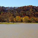
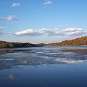
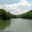
Stonewall Jackson Lake Stonewall Jackson Lake State Park Stonewall Jackson Lake State Park is a state park along the shores of Stonewall Jackson Lake, an impoundment on the West Fork River in the U.S. state of West Virginia. The lake is a project of the United States Army Corps of Engineers. The original park was completed in 1990 and consisted of a... |
Lewis Lewis County, West Virginia As of the census of 2000, there were 16,919 people, 6,946 households, and 4,806 families residing in the county. The population density was 44 people per square mile . There were 7,944 housing units at an average density of 21 per square mile... |
1,736 | 703 | |
|
|
|
|
|
|
 |
Tomlinson Run Tomlinson Run State Park Tomlinson Run State Park sits on along the small Ohio River tributary of the same name. The Hancock County park may be the only place in West Virginia that offers overnight accommodations in a yurt.... |
Hancock Hancock County, West Virginia As of the census of 2000, there were 32,667 people, 13,678 households, and 9,506 families residing in the county. The population density was 394 people per square mile . There were 14,728 housing units at an average density of 178 per square mile... |
1,396 | 565 | |
|
|
|
|||
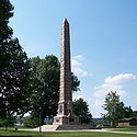 |
Tu-Endi-Wei Tu-Endie-Wei State Park Tu-Endie-Wei State Park is located at the confluence of the Kanawha River and the Ohio River in downtown Point Pleasant, West Virginia. The park commemorates the Battle of Point Pleasant, fought between the settler militia of Virginia and the forces of Shawnee Chief Cornstalk on October 10, 1774... |
Mason Mason County, West Virginia As of the census of 2000, there were 25,957 people, 10,587 households, and 7,569 families residing in the county. The population density was 60 people per square mile . There were 12,056 housing units at an average density of 28 per square mile... |
4 | 2 | |||||||
 |
Twin Falls Resort Twin Falls Resort State Park Twin Falls State Resort Park is a state park in Wyoming County, West Virginia. It is located west of Exit 42 from the West Virginia Turnpike.The park was opened in 1968 and was completed by 1975... |
Wyoming Wyoming County, West Virginia Wyoming County is a county located in the U.S. state of West Virginia. As of the 2010 census, the population was 23,796. Its county seat is Pineville. Wyoming County was created in 1850 from Logan County and named for the Delaware Indian word meaning "large plains."-Geography:According to the U.S... |
3,776 | 1528 | |
|
|
|
|
|
|
 |
Tygart Lake Tygart Lake State Park Tygart Lake State Park sits on 391 acres along the shores of Tygart Lake in Taylor County near Grafton, West Virginia, United States.-Facilities:* 20-room Tygart Lake Lodge* Lodge restaurant* 2 gift shops* Golfing* 11 cabins... |
Taylor Taylor County, West Virginia As of the census of 2000, there were 16,089 people, 6,320 households, and 4,487 families residing in the county. The population density was 93 people per square mile . There were 7,125 housing units at an average density of 41 per square mile... |
2,134 | 864 | |
|
|
|
|
|
|
 |
Valley Falls Valley Falls State Park Valley Falls State Park is a 1,145 acre day use facility sited along both banks of the Tygart Valley River. The park is located about 7 miles south of exit 137 of I-79, near Fairmont, West Virginia.... |
Marion Marion County, West Virginia | style="float:right;"|As of the census of 2000, there were 56,598 people, 23,652 households, and 15,515 families residing in the county. The population density was 183 people per square mile . There were 26,660 housing units at an average density of 86 per square mile... |
1,145 | 463 | |||||||
| Taylor Taylor County, West Virginia As of the census of 2000, there were 16,089 people, 6,320 households, and 4,487 families residing in the county. The population density was 93 people per square mile . There were 7,125 housing units at an average density of 41 per square mile... |
|||||||||||
 |
Watoga Watoga State Park Watoga State Park is the largest of West Virginia’s state parks, covering slightly over . It is located near Seebert in Pocahontas County, West Virginia.-History:... |
Pocahontas Pocahontas County, West Virginia As of the census of 2000, there were 9,131 people, 835 households, and 527 families residing in the county. The population density was 10 people per square mile . There were 7,594 housing units at an average density of 8 per square mile... |
10,100 | 4,090 | |
|
|
|
|
||
 |
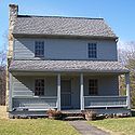
Watters Smith Memorial Watters Smith Memorial State Park Watters Smith Memorial State Park is a historical park and national historic district with a pioneer homestead and museum located in Harrison County, West Virginia... |
Harrison Harrison County, West Virginia As of the census of 2000, there were 68,652 people, 27,867 households, and 19,088 families residing in the county. The population density was 165 people per square mile . There were 31,112 housing units at an average density of 75 per square mile... |
532 | 215 | |
||||||
| Former West Virginia State Parks | |||||||||||
| Grandview State Park New River Gorge National River The New River Gorge National River is a unit of the United States National Park Service designed to protect and maintain the New River Gorge in southern West Virginia. Established in 1978, the NPS-protected area stretches for from just downstream of Hinton to Hawks Nest State Park near Ansted.New... - transferred to the National Park Service National Park Service The National Park Service is the U.S. federal agency that manages all national parks, many national monuments, and other conservation and historical properties with various title designations... in 1990. |
|||||||||||
 |
Mont Chateau State Park Mont Chateau State Park Mont Chateau State Park was formerly a state park located beside Cheat Lake in Monongalia County, West Virginia, USA.-Commissioning and operations:... - closed in 1977. |
||||||||||
| Morgan Morgan Monument - acquired in 1956 and transferred to West Virginia Division of Highways Law and government of West Virginia The capital and seat of government in West Virginia is the city of Charleston, located in the southwest area of the state.-Legislative branch:Like all states except Nebraska, West Virginia has a bicameral state legislature, the West Virginia Legislature. The lower house is the West Virginia House... for roadside rest area Rest area A rest area, travel plaza, rest stop, or service area is a public facility, located next to a large thoroughfare such as a highway, expressway, or freeway at which drivers and passengers can rest, eat, or refuel without exiting on to secondary roads... in 1970. |
|||||||||||
| James Rumsey Monument and Memorial - acquired in 1956 and transferred to Shepherdstown Shepherdstown, West Virginia Shepherdstown is a town in Jefferson County, West Virginia, United States, located along the Potomac River. It is the oldest town in the state, having been chartered in 1762 by Colonial Virginia's General Assembly. Since 1863, Shepherdstown has been in West Virginia, and is the oldest town in... for municipal park on 1978-11-06. |
|||||||||||
| Map of State Parks of West Virginia (Each dot is linked to the corresponding park article) |
See also
- Geography of West VirginiaGeography of West VirginiaThe Environment of West Virginia encompasses terrain and ecosystems ranging from arid plateaus to mountains. Most of West Virginia lies within the Appalachian mixed mesophytic forests ecoregion, while the higher elevations along the eastern border and in the panhandle lie within the...
- History of West VirginiaHistory of West VirginiaWest Virginia is one of two American states formed during the American Civil War , along with Nevada, and is the only state to form by seceding from a Confederate state...
- List of West Virginia state forests
- List of West Virginia wildlife management areas
- List of U.S. national parks
- List of U.S. state parks
- State parkState parkState parks are parks or other protected areas managed at the federated state level within those nations which use "state" as a political subdivision. State parks are typically established by a state to preserve a location on account of its natural beauty, historic interest, or recreational...
- TourismTourismTourism is travel for recreational, leisure or business purposes. The World Tourism Organization defines tourists as people "traveling to and staying in places outside their usual environment for not more than one consecutive year for leisure, business and other purposes".Tourism has become a...
- West VirginiaWest VirginiaWest Virginia is a state in the Appalachian and Southeastern regions of the United States, bordered by Virginia to the southeast, Kentucky to the southwest, Ohio to the northwest, Pennsylvania to the northeast and Maryland to the east...