

List of Registered Historic Places in Pawtucket, Rhode Island
Encyclopedia
This is intended to be a complete list of the properties and districts on the National Register of Historic Places
National Register of Historic Places
The National Register of Historic Places is the United States government's official list of districts, sites, buildings, structures, and objects deemed worthy of preservation...
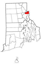
in Pawtucket
Pawtucket, Rhode Island
Pawtucket is a city in Providence County, Rhode Island, United States. The population was 71,148 at the 2010 census. It is the fourth largest city in the state.-History:...
, Rhode Island
Rhode Island
The state of Rhode Island and Providence Plantations, more commonly referred to as Rhode Island , is a state in the New England region of the United States. It is the smallest U.S. state by area...
, United States
United States
The United States of America is a federal constitutional republic comprising fifty states and a federal district...
. Latitude and longitude coordinates are provided for many National Register properties and districts; these locations may be seen together in a Google map.
There are 400 properties and districts listed on the National Register in Providence County, including 15 National Historic Landmark
National Historic Landmark
A National Historic Landmark is a building, site, structure, object, or district, that is officially recognized by the United States government for its historical significance...
s. The city of Pawtucket is the location of 50 these properties and districts, including 1 National Historic Landmark; they are listed here. Properties and districts located in the county's other municipalities are listed separately.
Current listings
| Landmark name | Image | Date listed | Location | Summary | |
|---|---|---|---|---|---|
| 1 | John E. Adams House John E. Adams House John E. Adams House is an historic house at 11 Allen Avenue in Pawtucket, Rhode Island.The house was built in 1867 and added to the National Historic Register in 1983.... |
11 Allen Ave. 41°52′59"N 71°22′38"W |
|||
| 2 | Art's Auto Art's Auto Art's Auto is an historic site at 5-7 Lonsdale Avenue in Pawtucket, Rhode Island.The structure was built in 1927 and added to the National Historic Register in 1978.... |
5-7 Lonsdale Ave. 41°52′7"N 71°23′56"W |
|||
| 3 | Bridge Mill Power Plant Bridge Mill Power Plant Bridge Mill Power Plant is an historic hydroelectric plant at 25 Roosevelt Avenue in Pawtucket, Rhode Island.The plant was built in 1893 and added to the National Historic Register in 1983.... |
 |
25 Roosevelt Ave. 41°52′35"N 71°23′4"W |
||
| 4 | G.A. Burnham House G.A. Burnham House The G.A. Burnham House is an historic house at 17 Nickerson Street in Pawtucket, Rhode Island.The house was built in 1902 and added to the National Historic Register in 1983.... |
17 Nickerson St. 41°52′58"N 71°23′20"W |
|||
| 5 | Childs-Brown House Childs-Brown House The Childs-Brown House is an historic house at 172 Pine Street in Pawtucket, Rhode Island.The house was built in 1868 and added to the National Historic Register in 1983.... |
172 Pine St. 41°52′27.83"N 71°23′23.06"W |
|||
| 6 | Church Hill Grammar School | 81 Park Pl. 41°52′33.16"N 71°23′15.7"W |
|||
| 7 | Church Hill Industrial District Church Hill Industrial District The Church Hill Industrial District is a historic district bounded by South Union, Pine, Baley, Commerce, Main, and Hill Streets in Pawtucket, Rhode Island.The district was added to the National Register of Historic Places in 1982.-See also:... |
 |
Roughly bounded by S. Union, Pine, Baley, Commerce, Main, and Hill Sts. 41°52′34"N 71°23′22"W Boundary increase (listed 2/7/2011): 60 Dexter St., 125 Goff Ave., 265 Pine St. |
||
| 8 | Collyer Monument Collyer Monument Collyer Monument is an historic monument in Mineral Spring Park in Pawtucket, Rhode Island.The monument was built in 1890 by Charles Dowler and added to the National Register of Historic Places in 1983.... |
Mineral Spring Park 41°52′29"N 71°23′35"W |
|||
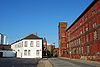
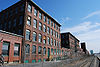
| 9 | Conant Thread-Coats & Clark Mill Complex District Conant Thread-Coats & Clark Mill Complex District Conant Thread—Coats & Clark Mill Complex District is a historic district roughly bounded by Lonsdale Avenue, Pine, Conant, Carpenter, and Rand Streets in Pawtucket, Rhode Island.... |
 |
Roughly bounded by Lonsdale Ave., Pine, Conant, Carpenter, and Rand Sts. 41°52′51"N 71°23′53"W |
||
| 10 | Lorenzo Crandall House Lorenzo Crandall House Lorenzo Crandall House is an historic house at 221 High Street in Pawtucket, Rhode Island.The house is built in 1848 and added to the National Register of Historic Places in 1984.... |
221 High St. 41°52′53"N 71°23′3"W |
|||
| 11 | Division Street Bridge Division Street Bridge Division Street Bridge is a historic bridge at Division Street on the Seekonk River in Pawtucket, Rhode Island.The bridge was built in 1876 and added to the National Register of Historic Places in 1983.... |
 |
Division St. at the Seekonk River Seekonk River The Seekonk River is a tidal extension of the Providence River in the U.S. state of Rhode Island. It flows approximately 8 km . Most historical scholars agree that the name is derived from two Native American words, sucki and honc... 41°52′20"N 71°23′6"W |
||
| 12 | Downtown Pawtucket Historic District Downtown Pawtucket Historic District Downtown Pawtucket Historic District is a historic district roughly bounded by Broad Street, Grant Street, High Street, East Avenue Ext. and Main Street in Pawtucket, Rhode Island.It was added to the National Register of Historic Places in 2007.... |
Roughly bounded by Broad St., Grant St., High St., the East Ave. Extension, and Main St. 41°52′43.29"N 71°23′5.48"W |
|||
| 13 | Exchange Street Historic District Exchange Street Historic District Exchange Street Historic District is a historic district roughly along Exchange, Front and Fountain Streets in Pawtucket, Rhode Island.The district was added to the National Register of Historic Places in 2002.... |
Roughly along Exchange, Front and Fountain Sts. 41°52′47"N 71°22′50"W |
|||
| 14 | Fifth Ward Wardroom Fifth Ward Wardroom Fifth Ward Wardroom is an historic site at 47 Mulberry Street in Pawtucket, Rhode Island.The site was built in 1886 and added to the National Historic Register in 1983.... |
47 Mulberry St. 41°52′27"N 71°23′36"W |
|||
| 15 | Fire Station No. 4 Fire Station No. 4 (Pawtucket, Rhode Island) Fire Station Number 4 is an historic fire station located at 474 Broadway in Pawtucket, Rhode Island. The station was built in 1890 and added to the National Historic Register in 1983. It was closed as a firehouse in 1974 when the current Fire Station #4 on Cottage Street opened. It is currently... |
474 Broadway 41°53′11"N 71°22′36"W |
|||
| 16 | First Ward Wardroom First Ward Wardroom First Ward Wardroom is an historic site at 171 Fountain Street in Pawtucket, Rhode Island.The site was built in 1886 and added to the National Historic Register in 1983.... |
171 Fountain St. 41°53′3.74"N 71°22′41.07"W |
|||
| 17 | Foster-Payne House Foster-Payne House Foster-Payne House is an historic house at 25 Belmont Street in Pawtucket, Rhode Island.The house was built in 1878 and added to the National Historic Register in 1983.... |
25 Belmont St. 41°51′46.05"N 71°23′44.9"W |
|||
| 18 | Fuller Houses Fuller Houses Fuller Houses are an historic site at 339 and 343 Broadway in Pawtucket, Rhode Island.The site was built in 1896 and added to the National Historic Register in 1983.... |
339-341 and 343-345 Broadway 41°53′4"N 71°22′38"W |
|||
| 19 | Gilbane's Service Center Building Gilbane's Service Center Building Gilbane's Service Center Building is an historic site at 175-191 Pawtucket Avenue in Pawtucket, Rhode Island.The site was built in 1931 and added to the National Historic Register in 1983.... |
175-191 Pawtucket Ave. 41°52′9"N 71°23′21"W |
|||
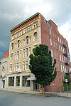
| 20 | Hope Webbing Company Mill Hope Webbing Company Mill Hope Webbing Company Mill is an historic site at 999-1005 Main Street in Pawtucket, Rhode Island.The mill was built in 1889 and added to the National Historic Register in 2006.... |
 |
999-1005 Main St. 41°51′46"N 71°24′4"W |
||
| 21 | Louis Kotzow House Louis Kotzow House The Louis Kotzow House is an historic site at 641 East Avenue in Pawtucket, Rhode Island.The house was built in 1875 and added to the National Historic Register in 1983.... |
641 East Ave. 41°51′37"N 71°23′24"W |
|||
| 22 | Leroy Theatre Leroy Theatre Leroy Theatre is an historic theater at 66 Broad Street in Pawtucket, Rhode Island.The theatre was built in 1922 and added to the National Register of Historic Places in 1983. The Theater was demolished in 1996 and replaced by a Walgreens Drugstore.... |
66 Broad St. 41°52′48"N 71°23′15"W |
|||
| 23 | Liberty Arming the Patriot Liberty Arming the Patriot Liberty Arming the Patriot is an historic sculpture at Park Place in Pawtucket, Rhode Island.The site was built in 1896 and added to the National Historic Register in 2001.-References:... |
Park Place 41°52′37"N 71°23′14"W |
|||
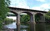
| 24 | Main Street Bridge Main Street Bridge (Pawtucket, Rhode Island) Main Street Bridge is an historic bridge on Main Street over the Pawtucket Falls in Pawtucket, Rhode Island.The bridge was built in 1858 and added to the National Register of Historic Places in 1983.... |
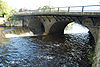 |
Main St. at Pawtucket Falls 41°52′35"N 71°23′2"W |
||
| 25 | Mitchell-Arnold House Mitchell-Arnold House Mitchell-Arnold House is an historic house at 41 Waldo Street in Pawtucket, Rhode Island.The house was built in 1871 and added to the National Historic Register in 1983.... |
41 Waldo St. 41°51′58"N 71°23′27"W |
|||
| 26 | Modern Diner Modern Diner Modern Diner is a historic restaurant at 364 East Avenue in Pawtucket, Rhode Island, United States.Built in 1940, as one of the Sterling Streamliners, the diner was added to the National Register of Historic Places in 1978.... |
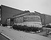 |
364 East Ave. 41°52′8"N 71°23′13"W |
||
| 27 | Nathaniel Montgomery House Nathaniel Montgomery House Nathaniel Montgomery House is an historic house at 178 High Street in Pawtucket, Rhode Island.The house was built in 1814 and added to the National Historic Register in 1984.... |
178 High St. 41°52′51"N 71°23′5"W |
|||
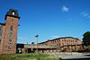
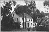
| 28 | Old Slater Mill | 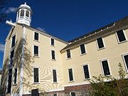 |
Roosevelt Ave. 41°52′39"N 71°22′57"W |
||
| 29 | Pawtucket Armory Pawtucket Armory Pawtucket Armory is an historic site at 172 Exchange Street in Pawtucket, Rhode Island.The armory was built in 1894 and added to the National Historic Register in 1983.... |
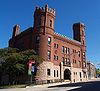 |
172 Exchange St. 41°52′49"N 71°22′49"W |
||
| 30 | Pawtucket City Hall Pawtucket City Hall Pawtucket City Hall is an historical site on 137 Roosevelt Avenue in Pawtucket, Rhode Island.The site was built in 1933 and added to the National Historic Register in 1983.-See also:*Pawtucket, Rhode Island... |
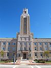 |
137 Roosevelt Ave. 41°52′45"N 71°22′57"W |
||
| 31 | Pawtucket Congregational Church Pawtucket Congregational Church Pawtucket Congregational Church is an historic congregational church at 40 and 56 Walcott Street in Pawtucket, Rhode Island.The church was built in 1867. The church has been active in the community and leased a building to the first Rhode Island Children's Museum from the 1970s to 1990s. The... |
 |
40 and 56 Walcott St. 41°52′36"N 71°22′54"W |
||
| 32 | Pawtucket Elks Lodge Building Pawtucket Elks Lodge Building The Pawtucket Elks Lodge Building is an historic site at 27 Exchange Street in Pawtucket, Rhode Island.The lodge was built in 1926 and added to the National Historic Register in 1983.... |
 |
27 Exchange 41°52′47.21"N 71°23′8.04"W |
||
| 33 | Pawtucket Post Office Pawtucket Post Office The Pawtucket Post Office is an historic site at 56 High Street in Pawtucket, Rhode Island.The office was built in 1896 and added to the National Historic Register in 1976.It is now part of the Pawtucket public library.... |
 |
56 High St. 41°52′42"N 71°23′4"W |
||
| 34 | Pawtucket Times Building Pawtucket Times Building Pawtucket Times Building is an historic site at 23 Exchange Street in Pawtucket, Rhode Island.The building was constructed in 1895 and added to the National Historic Register in 1983.... |
 |
23 Exchange St. 41°52′47.1"N 71°23′8.51"W |
||
| 35 | Pawtucket West High School Pawtucket West High School The Pawtucket West High School is an historic school at 485 East Avenue in Pawtucket, Rhode Island.The school was built in 1938 and added to the National Historic Register in 1983. The school was renamed Charles E. Shea High School to honor the well-known Pawtucket resident.... |
485 East Ave. 41°51′55"N 71°23′19"W |
|||
| 36 | Charles Payne House Charles Payne House The Charles Payne House is an historic site at 25 Brown Street in Pawtucket, Rhode Island.The house was built in 1855 and added to the National Historic Register in 1983.... |
25 Brown St. 41°52′17"N 71°23′29"W |
|||
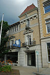
| 37 | Phillips Insulated Wire Company Complex Phillips Insulated Wire Company Complex Phillips Insulated Wire Company Complex is an historic site at 413 Central Avenue in Pawtucket, Rhode Island.The company was built in 1898 and added to the National Historic Register in 2004.... |
 |
413 Central Ave. 41°53′4"N 71°21′59"W |
||
| 38 | Pitcher-Goff House Pitcher-Goff House The Pitcher-Goff House is an historic site at 56 Walcott Street in Pawtucket, Rhode Island.The house was built in 1840 and added to the National Historic Register in 1976.... |
56 Walcott St. 41°52′37"N 71°22′49"W |
|||
| 39 | Potter-Collyer House Potter-Collyer House Potter-Collyer House is an historic house at 67 Cedar Street in Pawtucket, Rhode Island.The house was built in 1890 and added to the National Historic Register in 1983.... |
67 Cedar St. 41°52′24"N 71°23′23"W |
|||
| 40 | Quality Hill Historic District | Roughly bounded by Interstate 95 Interstate 95 Interstate 95 is the main highway on the East Coast of the United States, running parallel to the Atlantic Ocean from Maine to Florida and serving some of the most populated urban areas in the country, including Boston, Providence, New Haven, New York City, Newark, Philadelphia, Baltimore,... , Cottage, Lyon, Bend, and Potter Sts. 41°52′40"N 71°22′25"W |
|||
| 41 | Riverside Cemetery Riverside Cemetery (Pawtucket, Rhode Island) Riverside Cemetery is an historic cemetery in Pawtucket, Rhode Island on 724 Pleasant Street.The cemetery was built in 1874 and added to the National Historic Register in 1983.... |
724 Pleasant St. 41°51′33"N 71°22′56"W |
|||
| 42 | St. John the Baptist Church St. John the Baptist Church (Pawtucket, Rhode Island) St. John the Baptist Church is an historic church at 68 Slater in Pawtucket, Rhode Island.The church was built in 1925 and added to the National Historic Register in 1983.St... |
 |
68 Slater 41°52′24"N 71°23′52"W |
||
| 43 | St. Mary's Church of the Immaculate Conception Complex St. Mary's Church of the Immaculate Conception Complex St. Mary's Church of the Immaculate Conception Complex is an historic site at 103 Pine Street in Pawtucket, Rhode Island.The church was built in 1830. The building was added to the National Register of Historic Places in 1983. in 2009 the church's school closed, and students were allowed to... |
103 Pine St. 41°52′17"N 71°23′21"W |
|||
| 44 | St. Paul's Church Saint Paul's Church (Pawtucket, Rhode Island) St. Paul's Church is a historic Episcopal church at 50 Park Place in Pawtucket, Rhode Island.The church was built in 1901. It was added to the National Register of Historic Places in 1983.... |
 |
50 Park Pl. 41°52′32"N 71°23′14"W |
||
| 45 | Deborah Cook Sayles Public Library Deborah Cook Sayles Public Library The Deborah Cook Sayles Public Library is an historic site at 13 Summer Street in Pawtucket, Rhode Island.The library was built in 1899 and added to the National Historic Register in 1975.... |
 |
13 Summer St. 41°52′44"N 71°23′7"W |
||
| 46 | Scholze-Sayles House Scholze-Sayles House Scholze-Sayles House is an historic site at 625 East Avenue inPawtucket, Rhode Island.The house was built in 1874 and added to the National Historic Register in 1983.... |
625 East Ave. 41°51′38.82"N 71°23′21.28"W |
|||
| 47 | Slater Park Slater Park Slater Park is the oldest and largest public park in Pawtucket, Rhode Island. The park is named after Samuel Slater, a famous American industrialist who constructed America's first water-powered mill in Pawtucket. The park lies on the banks of the beautiful Ten Mile River and features the 1685... |
 |
Armistice Boulevard 41°52′7"N 71°20′43"W |
||
| 48 | South Street Historic District South Street Historic District (Pawtucket, Rhode Island) South Street Historic District is a historic district from South Street between Meadow and Fruit Streets in Pawtucket, Rhode Island.The district was added to the National Register of Historic Places in 1983.... |
Roughly South Street between Meadow and Fruit Sts. 41°52′17"N 71°22′47"W |
|||
| 49 | Joseph Spaulding House Joseph Spaulding House Joseph Spaulding House is an historic house at 30 Fruit Street in Pawtucket, Rhode Island.The house was built in 1828 and added to the National Historic Register in 1976.... |
30 Fruit St. 41°52′26"N 71°22′50"W |
|||
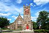
| 50 | Trinity Church Trinity Church (Pawtucket, Rhode Island) Trinity Church is an historic Roman Catholic church at 50 Main Street in Pawtucket, Rhode Island.The church was built in 1850 and added to the National Register of Historic Places in 1972.... |
50 Main St. 41°52′33.19"N 71°22′51.59"W |
See also
- List of National Historic Landmarks in Rhode Island
- National Register of Historic Places listings in Rhode Island