

List of Registered Historic Places in Mississippi
Encyclopedia
This is a list of properties and districts in Mississippi that are listed on the National Register of Historic Places
. There are 1,327 sites distributed among all of Mississippi's 82 counties.
The locations of National Register properties and districts (at least for all showing latitude and longitude coordinates below), may be seen in a Google map by clicking on "Map of all coordinates".
Adams County
Alcorn County
Amite County
Attala County
Benton County
Bolivar County
Calhoun County
Carroll County
Chickasaw County
Choctaw County
Claiborne County
Clarke County
Clay County
Coahoma County
Copiah County
Covington County
DeSoto County
Forrest County
Franklin County
George County
Greene County
Grenada County
Hancock County
Harrison County
Hinds County
Holmes County
Humphreys County
Issaquena County
Itawamba County
Jackson County
Jasper County
Jefferson County
Jefferson Davis County
Jones County
Kemper County
Lafayette County
Lamar County
Lauderdale County
Lawrence County
Leake County
Lee County
Leflore County
Lincoln County
Lowndes County
Madison County
Marion County
Marshall County
Monroe County
Montgomery County
Neshoba County
Newton County
Noxubee County
Oktibbeha County
Panola County
Pearl River County
Perry County
Pike County
Pontotoc County
Prentiss County
Quitman County
Rankin County
Scott County
Sharkey County
Simpson County
Smith County
Stone County
Sunflower County
Tallahatchie County
Tate County
Tippah County
Tishomingo County
Tunica County
Union County
Walthall County
Warren County
Washington County
Wayne County
Webster County
Wilkinson County
Winston County
Yalobusha County
Yazoo County
National Register of Historic Places
The National Register of Historic Places is the United States government's official list of districts, sites, buildings, structures, and objects deemed worthy of preservation...
. There are 1,327 sites distributed among all of Mississippi's 82 counties.
The locations of National Register properties and districts (at least for all showing latitude and longitude coordinates below), may be seen in a Google map by clicking on "Map of all coordinates".
Current listings by county
The following are approximate tallies of current listings by county. These counts are based on entries in the National Register Information Database as of March 13, 2009 and new weekly listings posted since then on the National Register of Historic Places web site. There are frequent additions to the listings and occasional delistings and the counts here are approximate and not official. New entries are added to the official Register on a weekly basis. Also, the counts in this table exclude boundary increase and decrease listings which modify the area covered by an existing property or district and which carry a separate National Register reference number.| County | # of Sites | |
|---|---|---|
| 1 | Adams National Register of Historic Places listings in Adams County, Mississippi This is a list of the National Register of Historic Places listings in Adams County, Mississippi.This is intended to be a complete list of the properties and districts on the National Register of Historic Places in Adams County, Mississippi, United States... |
118 |
| 2 | Alcorn National Register of Historic Places listings in Alcorn County, Mississippi This is a list of the National Register of Historic Places listings in Alcorn County, Mississippi.This is intended to be a complete list of the properties and districts on the National Register of Historic Places in Alcorn County, Mississippi, United States... |
20 |
| 3 | Amite National Register of Historic Places listings in Amite County, Mississippi This is a list of the National Register of Historic Places listings in Amite County, Mississippi.This is intended to be a complete list of the properties on the National Register of Historic Places in Amite County, Mississippi, United States... |
18 |
| 4 | Attala National Register of Historic Places listings in Attala County, Mississippi This is a list of the National Register of Historic Places listings in Attala County, Mississippi.This is intended to be a complete list of the properties and districts on the National Register of Historic Places in Attala County, Mississippi, United States... |
18 |
| 5 | Benton | 1 |
| 6 | Bolivar National Register of Historic Places listings in Bolivar County, Mississippi This is a list of the National Register of Historic Places listings in Bolivar County, Mississippi.This is intended to be a complete list of the properties and districts on the National Register of Historic Places in Bolivar County, Mississippi, United States... |
13 |
| 7 | Calhoun | 2 |
| 8 | Carroll National Register of Historic Places listings in Carroll County, Mississippi This is a list of the National Register of Historic Places listings in Carroll County, Mississippi.This is intended to be a complete list of the properties and districts on the National Register of Historic Places in Carroll County, Mississippi, United States... |
10 |
| 9 | Chickasaw | 9 |
| 10 | Choctaw | 5 |
| 11 | Claiborne National Register of Historic Places listings in Claiborne County, Mississippi This is a list of the National Register of Historic Places listings in Claiborne County, Mississippi.This is intended to be a complete list of the properties and districts on the National Register of Historic Places in Claiborne County, Mississippi, United States... |
36 |
| 12 | Clarke National Register of Historic Places listings in Clarke County, Mississippi This is a list of the National Register of Historic Places listings in Clarke County, Mississippi.This is intended to be a complete list of the properties and districts on the National Register of Historic Places in Clarke County, Mississippi, United States... |
50 |
| 13 | Clay National Register of Historic Places listings in Clay County, Mississippi This is a list of the National Register of Historic Places listings in Clay County, Mississippi.This is intended to be a complete list of the properties and districts on the National Register of Historic Places in Clay County, Mississippi, United States... |
27 |
| 14 | Coahoma National Register of Historic Places listings in Coahoma County, Mississippi This is a list of the National Register of Historic Places listings in Coahoma County, Mississippi.This is intended to be a complete list of the properties and districts on the National Register of Historic Places in Coahoma County, Mississippi, United States... |
21 |
| 15 | Copiah National Register of Historic Places listings in Copiah County, Mississippi This is a list of the National Register of Historic Places listings in Copiah County, Mississippi.This is intended to be a complete list of the properties and districts on the National Register of Historic Places in Copiah County, Mississippi, United States... |
32 |
| 16 | Covington | 1 |
| 17 | DeSoto | 8 |
| 18 | Forrest National Register of Historic Places listings in Forrest County, Mississippi This is a list of the National Register of Historic Places listings in Forrest County, Mississippi.This is intended to be a complete list of the properties and districts on the National Register of Historic Places in Forrest County, Mississippi, United States... |
19 |
| 19 | Franklin | 5 |
| 20 | George | 1 |
| 21 | Greene | 2 |
| 22 | Grenada National Register of Historic Places listings in Grenada County, Mississippi This is a list of the National Register of Historic Places listings in Grenada County, Mississippi.This is intended to be a complete list of the properties and districts on the National Register of Historic Places in Grenada County, Mississippi, United States... |
14 |
| 23 | Hancock National Register of Historic Places listings in Hancock County, Mississippi This is a list of the National Register of Historic Places listings in Hancock County, Mississippi.This is intended to be a complete list of the properties and districts on the National Register of Historic Places in Hancock County, Mississippi, United States... |
15 |
| 24 | Harrison National Register of Historic Places listings in Harrison County, Mississippi This is a list of the National Register of Historic Places listings in Harrison County, Mississippi.This is intended to be a complete list of the properties and districts on the National Register of Historic Places in Harrison County, Mississippi, United States... |
37 |
| 25 | Hinds National Register of Historic Places listings in Hinds County, Mississippi This is a list of the National Register of Historic Places listings in Hinds County, Mississippi.This is intended to be a complete list of the properties and districts on the National Register of Historic Places in Hinds County, Mississippi, United States... |
93 |
| 26 | Holmes National Register of Historic Places listings in Holmes County, Mississippi This is a list of the National Register of Historic Places listings in Holmes County, Mississippi.This is intended to be a complete list of the properties and districts on the National Register of Historic Places in Holmes County, Mississippi, United States... |
16 |
| 27 | Humphreys | 5 |
| 28 | Issaquena | 4 |
| 29 | Itawamba | 1 |
| 30 | Jackson National Register of Historic Places listings in Jackson County, Mississippi This is a list of the National Register of Historic Places listings in Jackson County, Mississippi.This is intended to be a complete list of the properties and districts on the National Register of Historic Places in Jackson County, Mississippi, United States... |
61 |
| 31 | Jasper | 5 |
| 32 | Jefferson National Register of Historic Places listings in Jefferson County, Mississippi This is a list of the National Register of Historic Places listings in Jefferson County, Mississippi.This is intended to be a complete list of the properties and districts on the National Register of Historic Places in Jefferson County, Mississippi, United States... |
23 |
| 33 | Jefferson Davis | 4 |
| 34 | Jones | 7 |
| 35 | Kemper | 5 |
| 36 | Lafayette National Register of Historic Places listings in Lafayette County, Mississippi This is a list of the National Register of Historic Places listings in Lafayette County, Mississippi.This is intended to be a complete list of the properties and districts on the National Register of Historic Places in Lafayette County, Mississippi, United States... |
15 |
| 37 | Lamar | 2 |
| 38 | Lauderdale National Register of Historic Places listings in Lauderdale County, Mississippi This is a list of the National Register of Historic Places listings in Lauderdale County, Mississippi.This is intended to be a complete list of the properties and districts on the National Register of Historic Places in Lauderdale County, Mississippi, United States... |
46 |
| 39 | Lawrence National Register of Historic Places listings in Lawrence County, Mississippi This is a list of the National Register of Historic Places listings in Lawrence County, Mississippi.This is intended to be a complete list of the properties and districts on the National Register of Historic Places in Lawrence County, Mississippi, United States... |
31 |
| 40 | Leake | 4 |
| 41 | Lee National Register of Historic Places listings in Lee County, Mississippi This is a list of the National Register of Historic Places listings in Lee County, Mississippi.This is intended to be a complete list of the properties and districts on the National Register of Historic Places in Lee County, Mississippi, United States... |
22 |
| 42 | Leflore National Register of Historic Places listings in Leflore County, Mississippi This is a list of the National Register of Historic Places listings in Leflore County, Mississippi.This is intended to be a complete list of the properties and districts on the National Register of Historic Places in Leflore County, Mississippi, United States... |
36 |
| 43 | Lincoln National Register of Historic Places listings in Lincoln County, Mississippi This is a list of the National Register of Historic Places listings in Lincoln County, Mississippi.This is intended to be a complete list of the properties and districts on the National Register of Historic Places in Lincoln County, Mississippi, United States... |
14 |
| 44 | Lowndes National Register of Historic Places listings in Lowndes County, Mississippi This is a list of the National Register of Historic Places listings in Lowndes County, Mississippi.This is intended to be a complete list of the properties and districts on the National Register of Historic Places in Lowndes County, Mississippi, United States... |
33 |
| 45 | Madison National Register of Historic Places listings in Madison County, Mississippi This is a list of the National Register of Historic Places listings in Madison County, Mississippi.This is intended to be a complete list of the properties and districts on the National Register of Historic Places in Madison County, Mississippi, United States... |
30 |
| 46 | Marion | 9 |
| 47 | Marshall National Register of Historic Places listings in Marshall County, Mississippi This is a list of the National Register of Historic Places listings in Marshall County, Mississippi.This is intended to be a complete list of the properties and districts on the National Register of Historic Places in Marshall County, Mississippi, United States... |
20 |
| 48 | Monroe National Register of Historic Places listings in Monroe County, Mississippi This is a list of the National Register of Historic Places listings in Monroe County, Mississippi.This is intended to be a complete list of the properties and districts on the National Register of Historic Places in Monroe County, Mississippi, United States... |
35 |
| 49 | Montgomery | 7 |
| 50 | Neshoba | 5 |
| 51 | Newton | 6 |
| 52 | Noxubee National Register of Historic Places listings in Noxubee County, Mississippi This is a list of the National Register of Historic Places listings in Noxubee County, Mississippi.This is intended to be a complete list of the properties and districts on the National Register of Historic Places in Noxubee County, Mississippi, United States... |
13 |
| 53 | Oktibbeha National Register of Historic Places listings in Oktibbeha County, Mississippi This is a list of the National Register of Historic Places listings in Oktibbeha County, Mississippi.This is intended to be a complete list of the properties and districts on the National Register of Historic Places in Oktibbeha County, Mississippi, United States... |
21 |
| 54 | Panola National Register of Historic Places listings in Panola County, Mississippi This is a list of the National Register of Historic Places listings in Panola County, Mississippi.This is intended to be a complete list of the properties and districts on the National Register of Historic Places in Panola County, Mississippi, United States... |
28 |
| 55 | Pearl River | 1 |
| 56 | Perry | 2 |
| 57 | Pike National Register of Historic Places listings in Pike County, Mississippi This is a list of the National Register of Historic Places listings in Pike County, Mississippi.This is intended to be a complete list of the properties and districts on the National Register of Historic Places in Pike County, Mississippi, United States... |
26 |
| 58 | Pontotoc | 3 |
| 59 | Prentiss | 2 |
| 60 | Quitman | 4 |
| 61 | Rankin National Register of Historic Places listings in Rankin County, Mississippi This is a list of the National Register of Historic Places listings in Rankin County, Mississippi.This is intended to be a complete list of the properties and districts on the National Register of Historic Places in Rankin County, Mississippi, United States... |
14 |
| 62 | Scott | 4 |
| 63 | Sharkey | 5 |
| 64 | Simpson | 3 |
| 65 | Smith | 1 |
| 66 | Stone | 1 |
| 67 | Sunflower | 4 |
| 68 | Tallahatchie | 9 |
| 69 | Tate National Register of Historic Places listings in Tate County, Mississippi This is a list of the National Register of Historic Places listings in Tate County, Mississippi.This is intended to be a complete list of the properties and districts on the National Register of Historic Places in Tate County, Mississippi, United States... |
10 |
| 70 | Tippah | 3 |
| 71 | Tishomingo National Register of Historic Places listings in Tishomingo County, Mississippi This is a list of the National Register of Historic Places listings in Tishomingo County, Mississippi.This is intended to be a complete list of the properties and districts on the National Register of Historic Places in Tishomingo County, Mississippi, United States... |
17 |
| 72 | Tunica | 8 |
| 73 | Union | 3 |
| 74 | Walthall | 4 |
| 75 | Warren National Register of Historic Places listings in Warren County, Mississippi This is a list of the National Register of Historic Places listings in Warren County, Mississippi.This is intended to be a complete list of the properties and districts on the National Register of Historic Places in Warren County, Mississippi, United States... |
68 |
| 76 | Washington National Register of Historic Places listings in Washington County, Mississippi This is a list of the National Register of Historic Places listings in Washington County, Mississippi.This is intended to be a complete list of the properties and districts on the National Register of Historic Places in Washington County, Mississippi, United States... |
19 |
| 77 | Wayne | 1 |
| 78 | Webster | 2 |
| 79 | Wilkinson National Register of Historic Places listings in Wilkinson County, Mississippi This is a list of the National Register of Historic Places listings in Wilkinson County, Mississippi.This is intended to be a complete list of the properties and districts on the National Register of Historic Places in Wilkinson County, Mississippi, United States... |
15 |
| 80 | Winston | 8 |
| 81 | Yalobusha | 1 |
| 82 | Yazoo National Register of Historic Places listings in Yazoo County, Mississippi This is a list of the National Register of Historic Places listings in Yazoo County, Mississippi.This is intended to be a complete list of the properties and districts on the National Register of Historic Places in Yazoo County, Mississippi, United States... |
14 |
| (duplicates) | (8) | |
| Total: | 1,327 | |
Adams CountyAdams County, MississippiAs of the census of 2000, there were 34,340 people, 13,677 households, and 9,409 families residing in the county. The population density was 75 people per square mile . There were 15,175 housing units at an average density of 33 per square mile...
Alcorn CountyAlcorn County, MississippiThere were 14,224 households out of which 30.90% had children under the age of 18 living with them, 54.50% were married couples living together, 11.50% had a female householder with no husband present, and 30.30% were non-families. 27.60% of all households were made up of individuals and 11.90% had...
Amite CountyAmite County, Mississippi-Demographics:As of the census of 2000, there were 13,599 people, 5,271 households, and 3,879 families residing in the county. The population density was 19 people per square mile . There were 6,446 housing units at an average density of 9 per square mile...
Attala CountyAttala County, Mississippi-Demographics:As of the census of 2000, there were 19,661 people, 7,567 households, and 5,380 families residing in the county. The population density was 27 people per square mile . There were 8,639 housing units at an average density of 12 per square mile...
Benton CountyBenton County, Mississippi-Demographics:At the 2000 census, there were 8,026 people, 2,999 households and 2,216 families residing in the county. The population density was 20 per square mile . There were 3,456 housing units at an average density of 8 per square mile...
| Landmark name | Image | Date listed | Location | City or Town | Summary | |
|---|---|---|---|---|---|---|
| 1 | Davis' Mills Battle Site | Off Mississippi Highway 7 34°58′43"N 89°15′7"W |
Michigan City Michigan City, Mississippi Michigan City is a community in Benton County, Mississippi, United States. It is located along Mississippi Highway 7 in north central Benton County, just south of the Tennessee state line, approximately three miles north of U. S. Route 72. Michigan City has a post office, with the ZIP code of 38647.... |
Bolivar CountyBolivar County, Mississippi-Demographics:As of the census of 2000, there were 40,633 people, 13,776 households, and 9,725 families residing in the county. The population density was 46 people per square mile . There were 14,939 housing units at an average density of 17 per square mile...
Calhoun CountyCalhoun County, MississippiCalhoun County is a county located in the U.S. state of Mississippi. As of 2010, the population was 14,962. Its county seat is Pittsboro. Calhoun County is named after John C. Calhoun, the U.S. Vice President and U.S...
| Landmark name | Image | Date listed | Location | City or Town | Summary | |
|---|---|---|---|---|---|---|
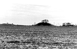
| 1 | New Liberty School | Junction of County Roads 427 and 428 33°53′8"N 89°13′30"W |
Vardaman Vardaman, Mississippi Vardaman is a town in Calhoun County, Mississippi, United States. The population was 1,065 at the 2000 census. The town was named for Mississippi Governor James K. Vardaman.-Geography:Vardaman is located at .... |
|||
| 2 | West Mound | Address Restricted | Slate Springs Slate Springs, Mississippi Slate Springs is a village in Calhoun County, Mississippi, United States. The population was 121 at the 2000 census.-Geography:Slate Springs is located at .... |
Carroll CountyCarroll County, Mississippi-Demographics:As of the census of 2000, there were 10,769 people, 4,071 households, and 3,069 families residing in the county. The population density was 17 people per square mile . There were 4,888 housing units at an average density of 8 per square mile...
Chickasaw CountyChickasaw County, Mississippi-National protected areas:* Natchez Trace Parkway * Tombigbee National Forest -Demographics:As of the census of 2000, there were 19,440 people, 7,253 households, and 5,287 families residing in the county. The population density was 39 people per square mile . There were 7,981 housing units at an...
| Landmark name | Image | Date listed | Location | City or Town | Summary | |
|---|---|---|---|---|---|---|
| 1 | Bynum Mound and Village Site Bynum Mound and Village Site The Bynum Mound and Village Site is a Middle Woodland period archaeological site located near Houston in Chickasaw County, Mississippi. The complex of six burial mounds was in use during the Miller 1 and Miller 2 phases of the Miller culture and was built between 100 BCE and 100 CE... (22CS501) |
Mile 232.4 on the Natchez Trace Parkway Natchez Trace Parkway The Natchez Trace Parkway is a National Park Service unit in the southeastern United States that commemorates the historic Old Natchez Trace and preserves sections of the original trail.... 33°53′53.16"N 88°56′53.09"W |
Houston Houston, Mississippi Houston is a city in and one of two county seats of Chickasaw County, Mississippi, United States. The population was 4,079 at the 2000 census. The land on which Houston, MS resides was donated to the city by Judge Joel Pinson on the condition that it would be named for Sam Houston, a childhood... |
|||
| 2 | Elliott-Donaldson House | 109 Church St. 34°0′24"N 88°45′24"W |
Okolona Okolona, Mississippi Okolona is a city in and one of the county seats of Chickasaw County, Mississippi, United States. The population was 3,056 at the 2000 census.-Geography:Okolona is located at .... |
|||
| 3 | Houston Carnegie Library | Madison and Huddleston Sts. 33°53′47"N 89°0′3"W |
Houston Houston, Mississippi Houston is a city in and one of two county seats of Chickasaw County, Mississippi, United States. The population was 4,079 at the 2000 census. The land on which Houston, MS resides was donated to the city by Judge Joel Pinson on the condition that it would be named for Sam Houston, a childhood... |
|||
| 4 | Judge Bates House | S. Monroe St. 33°53′46"N 89°0′1"W |
Houston Houston, Mississippi Houston is a city in and one of two county seats of Chickasaw County, Mississippi, United States. The population was 4,079 at the 2000 census. The land on which Houston, MS resides was donated to the city by Judge Joel Pinson on the condition that it would be named for Sam Houston, a childhood... |
|||
| 5 | Merchants and Farmers Bank Building | 423 Main St. 34°0′15"N 88°44′56"W |
Okolona Okolona, Mississippi Okolona is a city in and one of the county seats of Chickasaw County, Mississippi, United States. The population was 3,056 at the 2000 census.-Geography:Okolona is located at .... |
|||
| 6 | Okolona College | Mississippi Highway 245, N., 1.1 miles north of its junction with Mississippi Highways 32 and 41 34°1′4"N 88°45′27"W |
Okolona Okolona, Mississippi Okolona is a city in and one of the county seats of Chickasaw County, Mississippi, United States. The population was 3,056 at the 2000 census.-Geography:Okolona is located at .... |
|||
| 7 | Okolona Historic District | Roughly bounded by Fleming, Monroe, Buchanan, and Washington Sts. 34°0′18"N 88°45′3"W |
Okolona Okolona, Mississippi Okolona is a city in and one of the county seats of Chickasaw County, Mississippi, United States. The population was 3,056 at the 2000 census.-Geography:Okolona is located at .... |
|||
| 8 | Owl Creek Site | Along Davis Lake Rd., off the Natchez Trace Parkway Natchez Trace Parkway The Natchez Trace Parkway is a National Park Service unit in the southeastern United States that commemorates the historic Old Natchez Trace and preserves sections of the original trail.... and southwest of Tupelo |
Old Houlka | |||
| 9 | Thelma Mound Archaeological Site | Address Restricted | Houston Houston, Mississippi Houston is a city in and one of two county seats of Chickasaw County, Mississippi, United States. The population was 4,079 at the 2000 census. The land on which Houston, MS resides was donated to the city by Judge Joel Pinson on the condition that it would be named for Sam Houston, a childhood... |
|||
Choctaw CountyChoctaw County, Mississippi-National protected areas:* Natchez Trace Parkway * Tombigbee National Forest -Demographics:As of the census of 2000, there were 9,758 people, 3,686 households, and 2,668 families residing in the county. The population density was 23 people per square mile . There were 4,249 housing units at an...
| Landmark name | Image | Date listed | Location | City or Town | Summary | |
|---|---|---|---|---|---|---|
| 1 | Choctaw Lake Ranger House | Address Restricted | Ackerman Ackerman, Mississippi Ackerman is a town in Choctaw County, Mississippi, United States. The population was 1,696 at the 2000 census. It is the county seat of Choctaw County.It is named for an early landowner.-Geography:Ackerman is located at .... |
|||
| 2 | Col. James Drane House Col. James Drane House The Col. James Drane House is a Frontier I-House built in 1846. It is located on the historic Natchez Trace, at mile marker 180.7 on the modern Natchez Trace Parkway.The house was listed on the National Register of Historic Places in 1983.... |
Natchez Trace Parkway 33°17′43"N 89°24′2"W |
French Camp French Camp, Mississippi French Camp is a town in Choctaw County, Mississippi, United States, located eighty miles southwest of Tupelo. The population was 393 at the 2000 census.-Geography:French Camp is located at .... |
|||
| 3 | Janet's Mound Janet's Mound Janet's Mound, also known as 22-Ch-520, is an archeological site near French Camp, Mississippi. It is a area.... |
Address Restricted | French Camp French Camp, Mississippi French Camp is a town in Choctaw County, Mississippi, United States, located eighty miles southwest of Tupelo. The population was 393 at the 2000 census.-Geography:French Camp is located at .... |
|||
| 4 | Old Natchez Trace (230-3H) | South of Mathiston at Natchez Trace Parkway Natchez Trace Parkway The Natchez Trace Parkway is a National Park Service unit in the southeastern United States that commemorates the historic Old Natchez Trace and preserves sections of the original trail.... milepost 198 33°28′32"N 89°12′4"W |
Mathiston Mathiston, Mississippi Mathiston is a town in Choctaw and Webster Counties in the U.S. state of Mississippi. The population was 720 at the 2000 census.-Geography:Mathiston is located at . Most of the town is in Webster County with a portion on the south side extending into Choctaw County... |
Segment of the Natchez Trace Natchez Trace The Natchez Trace, also known as the "Old Natchez Trace", is a historical path that extends roughly from Natchez, Mississippi to Nashville, Tennessee, linking the Cumberland, Tennessee and Mississippi rivers... located at a Natchez Trace Parkway Natchez Trace Parkway The Natchez Trace Parkway is a National Park Service unit in the southeastern United States that commemorates the historic Old Natchez Trace and preserves sections of the original trail.... interpretive stop. |
||
| 5 | Col. John Weir House | 102 Ann St. 33°15′28"N 89°17′19"W |
Weir Weir, Mississippi Weir is a town in Choctaw County, Mississippi, United States. The population was 553 at the 2000 census.-Geography:Weir is located at , along the Yockanookany River.... |
Claiborne CountyClaiborne County, Mississippi-Demographics:As of the census of 2000, there were 11,831 people, 3,685 households, and 2,531 families residing in the county. The population density was 24 people per square mile . There were 4,252 housing units at an average density of 9 per square mile...
Clarke CountyClarke County, Mississippi-Demographics:As of the census of 2000, there were 17,955 people, 6,978 households, and 5,024 families residing in the county. The population density was 26 people per square mile . There were 8,100 housing units at an average density of 12 per square mile...
Clay CountyClay County, MississippiAs of the census of 2000, there were 21,979 people, 8,152 households, and 5,885 families residing in the county. The population density was 54 people per square mile . There were 8,810 housing units at an average density of 22 per square mile...
Coahoma CountyCoahoma County, Mississippi-Demographics:As of the census of 2000, there were 30,622 people, 10,553 households, and 7,482 families residing in the county. The population density was 55 people per square mile . There were 11,490 housing units at an average density of 21 per square mile...
Copiah CountyCopiah County, MississippiAs of the census of 2000, there were 28,757 people, 10,142 households, and 7,494 families residing in the county. The population density was 37 people per square mile . There were 11,101 housing units at an average density of 14 per square mile...
Covington CountyCovington County, Mississippi-2010 Census:As of the most recent census, 2010, the population of Covington County is 19,568, only a slight increase from 2000. Racially, the population was distributed with 62.7% being White, 34.7% Black/African American, 1.9% Hispanic/Latino, 0.2% Asian, 0.1% American Indian/Alaskan Native, and...
| Landmark name | Image | Date listed | Location | City or Town | Summary | |
|---|---|---|---|---|---|---|
| 1 | Covington County Courthouse | Dogwood Ave. 31°38′37"N 89°33′24"W |
Collins Collins, Mississippi Collins is a city in Covington County, Mississippi, United States. The population was 2,761 at the 2005 census. It is the county seat of Covington County.... |
DeSoto CountyDeSoto County, Mississippi-Demographics:As of the census of 2005 estimate, there were 137,004 people, 38,792 households, and 30,102 families residing in the county. The population density was 224 people per square mile . There were 40,795 housing units at an average density of 85 per square mile...
| Landmark name | Image | Date listed | Location | City or Town | Summary | |
|---|---|---|---|---|---|---|
| 1 | Dockery House | 3831 Robertson Gin Rd. 34°48′11"N 90°0′38"W |
Hernando Hernando, Mississippi Hernando is a city in central DeSoto County, Mississippi. The population was 6,812 at the 2000 census. The 2006 census estimate reflects a population of 10,580. Hernando is the county seat of DeSoto County, the second-most-populous county in the Memphis metropolitan area. US Hwy 51 and the I-55... |
|||
| 2 | Hernando Commerce Street Historic District | Roughly along Commerce St., west of West St., S. | Hernando Hernando, Mississippi Hernando is a city in central DeSoto County, Mississippi. The population was 6,812 at the 2000 census. The 2006 census estimate reflects a population of 10,580. Hernando is the county seat of DeSoto County, the second-most-populous county in the Memphis metropolitan area. US Hwy 51 and the I-55... |
|||
| 3 | Hernando Courthouse Square District | Roughly bounded by Caffey, W. Commerce, and Losher Sts., and Mississippi Highway 51 34°49′23"N 89°59′41"W |
Hernando Hernando, Mississippi Hernando is a city in central DeSoto County, Mississippi. The population was 6,812 at the 2000 census. The 2006 census estimate reflects a population of 10,580. Hernando is the county seat of DeSoto County, the second-most-populous county in the Memphis metropolitan area. US Hwy 51 and the I-55... |
|||
| 4 | Hernando North Side Historic District | North of Holly Springs St., east of U.S. Route 51 U.S. Route 51 U.S. Route 51 is a north–south United States highway that runs for 1,286 miles from the western suburbs of New Orleans, Louisiana to within of the Wisconsin-Michigan border. Much of the highway in Illinois and southern Wisconsin runs parallel to or overlaps Interstate 39... , west of Northview St., on W. Northern St., W. Valley St., Shady Ln., and Holly Springs St. 34°49′30"N 89°59′32"W |
Hernando Hernando, Mississippi Hernando is a city in central DeSoto County, Mississippi. The population was 6,812 at the 2000 census. The 2006 census estimate reflects a population of 10,580. Hernando is the county seat of DeSoto County, the second-most-populous county in the Memphis metropolitan area. US Hwy 51 and the I-55... |
|||
| 5 | Hernando South Side (Magnolia) Historic District | Roughly bounded by Oak Grove Rd., Magnolia Dr., W. Center St., and Church St. 34°49′12"N 89°59′27"W |
Hernando Hernando, Mississippi Hernando is a city in central DeSoto County, Mississippi. The population was 6,812 at the 2000 census. The 2006 census estimate reflects a population of 10,580. Hernando is the county seat of DeSoto County, the second-most-populous county in the Memphis metropolitan area. US Hwy 51 and the I-55... |
|||
| 6 | Felix Labauve House | 235 Magnolia Dr. 34°49′11"N 89°59′23"W |
Hernando Hernando, Mississippi Hernando is a city in central DeSoto County, Mississippi. The population was 6,812 at the 2000 census. The 2006 census estimate reflects a population of 10,580. Hernando is the county seat of DeSoto County, the second-most-populous county in the Memphis metropolitan area. US Hwy 51 and the I-55... |
|||
| 7 | Miller Plantation House | Miller Rd. 34°55′28"N 89°46′45"W |
Olive Branch Olive Branch, Mississippi Olive Branch is a city in DeSoto County, Mississippi, United States. The population was 21,054 at the 2000 census. A July 1, 2008 United States Census Bureau estimate placed the population at 31,830, making it the ninth-largest city in the state of Mississippi... |
|||
| 8 | Robertson-Yates House | 5000 Robertson Gin Rd. 34°47′10"N 90°1′23"W |
Hernando Hernando, Mississippi Hernando is a city in central DeSoto County, Mississippi. The population was 6,812 at the 2000 census. The 2006 census estimate reflects a population of 10,580. Hernando is the county seat of DeSoto County, the second-most-populous county in the Memphis metropolitan area. US Hwy 51 and the I-55... |
Forrest CountyForrest County, MississippiThe median income for a household in the county was $27,420, and the median income for a family was $35,791. Males had a median income of $28,742 versus $20,500 for females. The per capita income for the county was $15,160...
Franklin CountyFranklin County, Mississippi-Demographics:As of the census of 2000, there were 8,448 people, 3,211 households, and 2,337 families residing in the county. The population density was 15 people per square mile . There were 4,119 housing units at an average density of 7 per square mile...
| Landmark name | Image | Date listed | Location | City or Town | Summary | |
|---|---|---|---|---|---|---|
| 1 | Charles Walton Beam House | Junction of Bogue Chitto-Meadville Rd. and Upper Meadville-Summit Rd., 7 miles south of McCall Creek 31°25′10"N 90°40′54"W |
McCall Creek McCall Creek, Mississippi McCall Creek is an unincorporated community in Franklin County, Mississippi, United States. It is located along U.S. Highway 84 in eastern Franklin County, approximately two miles west of the Franklin-Lincoln County line.... |
|||
| 2 | Clear Springs Recreation Area | Area of Clear Springs Lake 31°25′27"N 90°59′12"W |
Roxie Roxie, Mississippi Roxie is a town in Franklin County, Mississippi, United States. The population was 569 at the 2000 census.-Geography:Roxie is located at .According to the United States Census Bureau, the town has a total area of , all of it land.... |
|||
| 3 | Eddiceton Bridge | Spans the Homochitto River Homochitto River The Homochitto River is a river in the U.S. state of Mississippi. It flows from its source in southwest Mississippi for about west and south, emptying into the Mississippi River between Natchez and Woodville.-Course:... on a county road 31°29′33"N 90°47′21"W |
Eddiceton | |||
| 4 | Franklin County Courthouse | Courthouse Sq. 31°28′20"N 90°53′35"W |
Meadville Meadville, Mississippi Meadville is a town in Franklin County, Mississippi, United States. The population was 519 at the 2000 census. It is the county seat of Franklin County... |
|||
| 5 | Lucien Bridge | Over McCall Creek, on Stewart Rd., at Lucien 31°30′40"N 90°39′59"W |
McCall Creek McCall Creek, Mississippi McCall Creek is an unincorporated community in Franklin County, Mississippi, United States. It is located along U.S. Highway 84 in eastern Franklin County, approximately two miles west of the Franklin-Lincoln County line.... |
George CountyGeorge County, Mississippi-Demographics:As of the census of 2000, there were 19,144 people, 6,742 households, and 5,305 families residing in the county. The population density was 40 people per square mile . There were 7,513 housing units at an average density of 16 per square mile...
| Landmark name | Image | Date listed | Location | City or Town | Summary | |
|---|---|---|---|---|---|---|
| 1 | Bilbo Basin Shell Deposit Site | Eastern side of the Pascagoula River Pascagoula River The Pascagoula River is a river, about 80 mi long, in southeastern Mississippi in the United States. The river drains an area of about 8,800 sq mi and flows into Mississippi Sound of the Gulf of Mexico.... , southwest of Lucedale 30°49′20.5"N 88°44′34"W |
Lucedale Lucedale, Mississippi Lucedale is a city in George County, Mississippi, United States. It is part of the Pascagoula, Mississippi Metropolitan Statistical Area. The population was 2,458 at the 2000 census... |
Greene CountyGreene County, Mississippi-Demographics:As of the census of 2000, there were 13,299 people, 4,148 households, and 3,152 families residing in the county. The population density was 19 people per square mile . There were 4,947 housing units at an average density of 7 per square mile...
| Landmark name | Image | Date listed | Location | City or Town | Summary | |
|---|---|---|---|---|---|---|
| 1 | Leaf River Bridge | Spans the Leaf River Leaf River (Mississippi) The Leaf River is a river, about 180 mi long, in southern Mississippi in the United States. It is a principal tributary of the Pascagoula River, which flows to the Gulf of Mexico.-Course:... north of McClain on a county road 31°7′39"N 88°49′1"W |
McClain | |||
| 2 | Vernal Presbyterian Church Vernal Presbyterian Church Vernal Presbyterian Church is a historic church in Lucedale, Mississippi.It was built in 1908 and added to the National Register in 2002.... |
455 McInnis-Vernal Rd. 31°2′4"N 88°36′42"W |
Lucedale Lucedale, Mississippi Lucedale is a city in George County, Mississippi, United States. It is part of the Pascagoula, Mississippi Metropolitan Statistical Area. The population was 2,458 at the 2000 census... |
Grenada CountyGrenada County, Mississippi-Demographics:As of the census of 2000, there were 23,263 people, 8,820 households, and 6,297 families residing in the county. The population density was 55 people per square mile . There were 9,973 housing units at an average density of 24 per square mile...
Hancock CountyHancock County, Mississippi-Demographics:As of the census of 2000, there were 42,967 people, 16,897 households, and 11,827 families residing in the county. The population density was 90 people per square mile . There were 21,072 housing units at an average density of 44 per square mile...
Harrison CountyHarrison County, Mississippi-National protected areas:* De Soto National Forest * Gulf Islands National Seashore - Demographics :As of the census of 2000, there were 189,601 people, 71,538 households, and 48,574 families residing in the county. The population density was 326 people per square mile . There were 79,636 housing...
Hinds CountyHinds County, MississippiAs of the census of 2000, there were 250,800 people, 91,030 households, and 62,355 families residing in the county. The population density was 288 people per square mile . There were 100,287 housing units at an average density of 115 per square mile...
Holmes CountyHolmes County, Mississippi-National protected areas:*Hillside National Wildlife Refuge *Mathews Brake National Wildlife Refuge *Morgan Brake National Wildlife Refuge*Theodore Roosevelt National Wildlife Refuge -Demographics:...
Humphreys CountyHumphreys County, Mississippi-Demographics:At the 2000 census, there were 11,206 people, 3,765 households and 2,695 families residing in the county. The population density was 27 per square mile . There were 4,138 housing units at an average density of 10 per square mile...
| Landmark name | Image | Date listed | Location | City or Town | Summary | |
|---|---|---|---|---|---|---|
| 1 | Belzoni Mound (22HU500) | Address Restricted | Belzoni Belzoni, Mississippi Belzoni is a city in Humphreys County, Mississippi, in the Mississippi Delta region, on the Yazoo River. The population was 2,663 at the 2000 census. It is the county seat of Humphreys County... |
|||
| 2 | Jaketown Site Jaketown Site Jaketown Site is an archaeological site with two prehistoric earthwork mounds in Humphreys County, Mississippi, United States. While the mounds have not been excavated, distinctive pottery sherds found in the area lead scholars to date the mounds' construction and use to the Mississippian culture... |
 |
Western side of Mississippi Highway 7, approximately 7 miles north of Belzoni 33°14′13.542"N 90°29′13.2936"W |
Belzoni Belzoni, Mississippi Belzoni is a city in Humphreys County, Mississippi, in the Mississippi Delta region, on the Yazoo River. The population was 2,663 at the 2000 census. It is the county seat of Humphreys County... |
||
| 3 | Midnight Mound Site (22HU509) | Address Restricted | Midnight Midnight, Mississippi Midnight is an unincorporated community located in Humphreys County, Mississippi, United States. Midnight is approximately north of Louise and southwest of Silver City along Mississippi Highway 149.... |
|||
| 4 | Parker-Summerfield Mound Archeological Site | Address Restricted | Midnight Midnight, Mississippi Midnight is an unincorporated community located in Humphreys County, Mississippi, United States. Midnight is approximately north of Louise and southwest of Silver City along Mississippi Highway 149.... |
|||
| 5 | Slate Archeological Site | Address Restricted | Lake City |
Issaquena CountyIssaquena County, Mississippi-Demographics:As of the census of 2000, there were 2,274 people, 726 households, and 509 families residing in the county. The population density was 5.15 people per square mile . There were 877 housing units at an average density of 2 per square mile...
| Landmark name | Image | Date listed | Location | City or Town | Summary | |
|---|---|---|---|---|---|---|
| 1 | Aden Site (22Is509;22M3) Aden Site The Aden Site is an archaeological site that is the type site for the Aden Phase of Lower Yazoo Basin Coles Creek culture chronology... |
Address Restricted | Valley Park Valley Park, Mississippi Valley Park is an unincorporated community in Issaquena County, Mississippi, United States. Its elevation is 95 feet . Although unincorporated, it has a post office, with the ZIP code of 39177. On April 24, 2010 Valley Park was the site of a strong tornado, though no injuries were reported. The... |
|||
| 2 | Grace Archeological Site | Address Restricted | Grace Grace, Mississippi Grace is an unincorporated community in Issaquena County, Mississippi, United States. It is located several miles northeast of Mayersville.Although it is unincorporated, Grace has a post office, with the ZIP code of 38745.... |
|||
| 3 | Mayersville Archeological Site | Address Restricted | Mayersville Mayersville, Mississippi Mayersville is a town in Issaquena County, Mississippi, United States. The population was 795 at the 2000 census. The town was named for David Mayer, on whose plantation the town was built. It is the county seat of Issaquena County. One of its more famous natives is Unita Blackwell, Mississippi's... |
|||
| 4 | Railroad Section Foreman's House | No. 3 Railroad Rd. 32°38′10"N 90°51′54"W |
Valley Park Valley Park, Mississippi Valley Park is an unincorporated community in Issaquena County, Mississippi, United States. Its elevation is 95 feet . Although unincorporated, it has a post office, with the ZIP code of 39177. On April 24, 2010 Valley Park was the site of a strong tornado, though no injuries were reported. The... |
Itawamba CountyItawamba County, MississippiIn 2000, there were 8,773 households out of which 33.20% had children under the age of 18 living with them, 60.30% were married couples living together, 9.90% had a female householder with no husband present, and 25.90% were non-families. 23.40% of all households were made up of individuals and...
| Landmark name | Image | Date listed | Location | City or Town | Summary | |
|---|---|---|---|---|---|---|
| 1 | Pharr Mounds Pharr Mounds Pharr Mounds is a Middle Woodland period archaeological site located near Tupelo in parts of Itawamba and Prentiss County in northern Mississippi.... |
Mile 286.7 on the Natchez Trace Parkway Natchez Trace Parkway The Natchez Trace Parkway is a National Park Service unit in the southeastern United States that commemorates the historic Old Natchez Trace and preserves sections of the original trail.... 34°27′58.1"N 88°24′58"W |
Kirkville | Extends into Prentiss County |
Jackson CountyJackson County, MississippiThere were 47,676 households out of which 37.00% had children under the age of 18 living with them, 55.70% were married couples living together, 14.50% had a female householder with no husband present, and 25.10% were non-families. 20.80% of all households were made up of individuals and 7.10% had...
Jasper CountyJasper County, Mississippi-History:Jasper County was formed in 1833 from the middle section of what been Jones County. It was named for Sgt. William Jasper who first distinguished himself in the defense of Fort Moultrie in 1776. When a shell from a British warship shot away the flagstaff, he recovered the flag, raised it on...
| Landmark name | Image | Date listed | Location | City or Town | Summary | |
|---|---|---|---|---|---|---|
| 1 | Archeological Site No. 22-Js-572 | Address Restricted | Bay Springs Bay Springs, Mississippi Bay Springs is a city in Jasper County, Mississippi, United States. The population was 2,097 at the 2000 census. It is located at the intersection of state highways 15 and 18. The area was settled in the 1880s by Joe Blankenship, who built the saw mill that became the town's industrial base... |
|||
| 2 | Archeological Site No. 22JS587 | Address Restricted | Bay Springs Bay Springs, Mississippi Bay Springs is a city in Jasper County, Mississippi, United States. The population was 2,097 at the 2000 census. It is located at the intersection of state highways 15 and 18. The area was settled in the 1880s by Joe Blankenship, who built the saw mill that became the town's industrial base... |
|||
| 3 | Graham House | 36 County Road 1824 | Rose Hill | |||
| 4 | Old Jasper County Jail | Mississippi Highway 503 32°1′48"N 89°2′11"W |
Paulding Paulding, Mississippi Paulding is an unincorporated community in and one of the two county seats of Jasper County, Mississippi, United States. It is the only unincorporated county seat in Mississippi. It was named in honor of Revolutionary War hero John Paulding.... |
|||
| 5 | Montrose Presbyterian Church Montrose Presbyterian Church Montrose Presbyterian Church is a historic church on Cty Rd. 20 in Montrose, Mississippi.It was built in 1910 and added to the National Register in 2003.... |
County Road 20 32°7′24"N 89°14′12"W |
Montrose Montrose, Mississippi Montrose is a town in Jasper County, Mississippi, United States. The population was 127 at the 2000 census.-Geography:Montrose is located at .... |
Jefferson CountyJefferson County, Mississippi-National protected areas:* Homochitto National Forest * Natchez Trace Parkway -Demographics:As of the census of 2000, there were 9,740 people, 3,308 households, and 2,338 families residing in the county. The population density was 19 people per square mile . There were 3,819 housing units at an...
Jefferson Davis CountyJefferson Davis County, Mississippi-Demographics:As of the census of 2000, there were 13,962 people, 5,177 households, and 3,768 families residing in the county. The population density was 34 people per square mile . There were 5,891 housing units at an average density of 14 per square mile...
| Landmark name | Image | Date listed | Location | City or Town | Summary | |
|---|---|---|---|---|---|---|
| 1 | 1907 House | East of Prentiss on Fort Stephens Rd. 31°35′34"N 89°51′32"W |
Prentiss Prentiss, Mississippi Prentiss is a town in Jefferson Davis County, Mississippi, United States. The population was 1,158 at the 2000 census. It is the county seat of Jefferson Davis County... |
|||
| 2 | John Fielding Holloway House | U.S. Route 84 U.S. Route 84 U.S. Route 84 is an east–west United States highway. It started as a short Georgia-Alabama route in the original 1926 scheme, but now extends all the way to Colorado. The highway's eastern terminus is a short distance east of Midway, Georgia, at an intersection with I-95. The road continues... , about 450 feet east of its junction with Mississippi Highway 541, in Mount Carmel 31°38′42"N 89°47′17"W |
Prentiss Prentiss, Mississippi Prentiss is a town in Jefferson Davis County, Mississippi, United States. The population was 1,158 at the 2000 census. It is the county seat of Jefferson Davis County... |
|||
| 3 | Jefferson Davis County Courthouse | 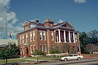 |
Junction of N. Columbia Ave. and 3rd St. 31°36′2"N 89°51′55"W |
Prentiss Prentiss, Mississippi Prentiss is a town in Jefferson Davis County, Mississippi, United States. The population was 1,158 at the 2000 census. It is the county seat of Jefferson Davis County... |
||
| 4 | Stephen H. Wilkes House | 1522 S. Williamsburg Rd. 31°26′6"N 89°44′57"W |
Bassfield Bassfield, Mississippi Bassfield is a town in Jefferson Davis County, Mississippi, United States. The population was 315 at the 2000 census.-Geography:Bassfield is located at .... |
Jones CountyJones County, Mississippi-History:Jones County, formed out parts of Covington and Wayne counties, was established on January 24, 1826 and was named for John Paul Jones. There are other counties named Jones, but it appears that this is the only one named for John Paul Jones...
| Landmark name | Image | Date listed | Location | City or Town | Summary | |
|---|---|---|---|---|---|---|
| 1 | Amos Deason House | 410 N. Deason St. 31°36′33"N 89°11′49"W |
Ellisville Ellisville, Mississippi Ellisville is a city in Jones County, Mississippi, United States. The population was 3,465 at the time of the 2000 census.-History:The city is named for Powhatan Ellis, a former U.S. Senator for Mississippi and descendant of Chief Powhatan, father of Pocahontas... |
|||
| 2 | Fishtrap Bluff Fishweir | Address Restricted | Ellisville Ellisville, Mississippi Ellisville is a city in Jones County, Mississippi, United States. The population was 3,465 at the time of the 2000 census.-History:The city is named for Powhatan Ellis, a former U.S. Senator for Mississippi and descendant of Chief Powhatan, father of Pocahontas... |
|||
| 3 | G.W.O. Site | Address Restricted | Lanham | |||
| 4 | Jones County Courthouse and Confederate Monument at Ellisville | Bounded by Court, Holly, Calhoun and Ivy Sts. 31°36′14"N 89°11′42"W |
Ellisville Ellisville, Mississippi Ellisville is a city in Jones County, Mississippi, United States. The population was 3,465 at the time of the 2000 census.-History:The city is named for Powhatan Ellis, a former U.S. Senator for Mississippi and descendant of Chief Powhatan, father of Pocahontas... |
|||
| 5 | Laurel Central Historic District | Roughly bounded by 10th and 13th Sts., 1st Ave., 7th and 5th Sts., and 8th Ave. 31°41′52"N 89°7′54"W |
Laurel Laurel, Mississippi Laurel is a city located in Jones County in Mississippi, a state of the United States of America. As of the 2000 census, the city had a total population of 18,393 although a significant population increase has been reported following Hurricane Katrina. Located in southeast Mississippi, southeast of... |
|||
| 6 | New Orleans and Northeastern Railroad Depot Laurel (Amtrak station) The Laurel Amtrak Station, located in Laurel, Mississippi, is served by the passenger train. The street address is 230 North Maple Street, in the heart of downtown Laurel... |
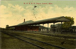 |
Maple St. 31°41′32"N 89°7′39"W |
Laurel Laurel, Mississippi Laurel is a city located in Jones County in Mississippi, a state of the United States of America. As of the 2000 census, the city had a total population of 18,393 although a significant population increase has been reported following Hurricane Katrina. Located in southeast Mississippi, southeast of... |
||
| 7 | Newell Rogers House | 706 N. 6th Ave. 31°41′49"N 89°8′1"W |
Laurel Laurel, Mississippi Laurel is a city located in Jones County in Mississippi, a state of the United States of America. As of the 2000 census, the city had a total population of 18,393 although a significant population increase has been reported following Hurricane Katrina. Located in southeast Mississippi, southeast of... |
Kemper CountyKemper County, Mississippi-Demographics:As of the census of 2000, there were 10,453 people, 3,909 households, and 2,787 families residing in the county. The population density was 14 people per square mile . There were 4,533 housing units at an average density of 6 per square mile...
| Landmark name | Image | Date listed | Location | City or Town | Summary | |
|---|---|---|---|---|---|---|
| 1 | Oliver House | 1 mile southwest of Moscow off Mississippi Highway 493 32°42′6"N 88°48′54"W |
Moscow Moscow, Mississippi Moscow is an unincorporated community in Kemper County, Mississippi, United States. It lies along State Highway 493 southwest of the city of De Kalb, the county seat of Kemper County. Its elevation is 509 feet .... |
|||
| 2 | Perkins House | Murphy Hardy Rd., northwest of its junction with Mississippi Highway 493 32°42′39"N 88°49′27"W |
DeKalb | |||
| 3 | Porterville General Store | Old Mississippi Highway 45 32°41′17"N 88°28′18"W |
Porterville Porterville, Mississippi Porterville is an unincorporated community in Kemper County, Mississippi, United States. It lies a slight distance away from U.S. Route 45 southeast of the city of De Kalb, the county seat of Kemper County. Its elevation is 200 feet . Although it is unincorporated, it has a post office,... |
|||
| 4 | Sucarnoochee River Fishweir | Address Restricted | Porterville Porterville, Mississippi Porterville is an unincorporated community in Kemper County, Mississippi, United States. It lies a slight distance away from U.S. Route 45 southeast of the city of De Kalb, the county seat of Kemper County. Its elevation is 200 feet . Although it is unincorporated, it has a post office,... |
|||
| 5 | Zion Baptist Church Zion Baptist Church (Collinsville, Mississippi) Zion Baptist Church in Collinsville, Mississippi is a Carpenter Gothic church built in 1910. It was listed on the National Register of Historic Places in 2002.... |
Little Zion Church Rd., W., 2 miles north of the Lauderdale/Kemper county line 32°36′32"N 88°52′53"W |
Collinsville Collinsville, Mississippi Collinsville is a census-designated place in Lauderdale County, Mississippi, United States. The population was 1,823 at the 2000 census.-Geography:Collinsville is located at .... |
Lafayette CountyLafayette County, Mississippi-Demographics:As of the census of 2000, there were 38,744 people, 14,373 households, and 8,321 families residing in the county. The population density was 61 people per square mile . There were 16,587 housing units at an average density of 26 per square mile...
Lamar CountyLamar County, Mississippi-Demographics:As of the census of 2000, there were 39,070 people, 14,396 households, and 10,725 families residing in the county. The population density was 79 people per square mile . There were 15,433 housing units at an average density of 31 per square mile...
| Landmark name | Image | Date listed | Location | City or Town | Summary | |
|---|---|---|---|---|---|---|
| 1 | Old Municipal Courtroom and Jail | 405 Pine St. at Railroad Ave. 31°24′56"N 89°32′40"W |
Sumrall Sumrall, Mississippi Sumrall is a town in Lamar County, Mississippi, United States. It is part of the Hattiesburg, Mississippi Metropolitan Statistical Area. The population was 1,005 at the 2000 census.-Geography:Sumrall is located at .... |
|||
| 2 | U.S. Post Office | 104 Heber Ladner Dr. 31°0′1"N 89°27′11"W |
Lumberton Lumberton, Mississippi Lumberton is a city in Lamar and Pearl River Counties in the U.S. state of Mississippi. It is part of the Hattiesburg, Mississippi Metropolitan Statistical Area. The population was 2,228 at the 2000 census.-Geography:... |
Lauderdale CountyLauderdale County, Mississippi-Demographics:As of the census of 2000, there were 78,161 people, 29,990 households, and 20,573 families residing in the county. The population density was 111 people per square mile . There were 33,418 housing units at an average density of 48 per square mile...
Lawrence CountyLawrence County, MississippiLawrence County is a county located in the U.S. state of Mississippi. As of 2010, the population was 12,929. Its county seat is Monticello. Lawrence County is named for the naval hero James Lawrence.-Geography:...
Leake CountyLeake County, Mississippi-Demographics:As of the census of 2000, there were 20,940 people, 7,611 households, and 5,563 families residing in the county. The population density was 36 people per square mile . There were 8,585 housing units at an average density of 15 per square mile...
| Landmark name | Image | Date listed | Location | City or Town | Summary | |
|---|---|---|---|---|---|---|
| 1 | Jordan House | E. Franklin St. 32°44′16"N 89°31′50"W |
Carthage Carthage, Mississippi Carthage is a city in Leake County, Mississippi, United States. The population was 4,637 at the 2000 census. It is the county seat of Leake County.... |
|||
| 2 | Robinson Road (190-191-3M) | Southwest of Kosciusko 32°42′37"N 89°42′31"W |
Kosciusko Kosciusko, Mississippi Kosciusko is a city in Attala County, Mississippi, United States. The population was 7,372 at the 2000 census. It is the county seat of Attala County.... |
|||
| 3 | Steep Mound Site (22LK26) | Address Restricted | Carthage Carthage, Mississippi Carthage is a city in Leake County, Mississippi, United States. The population was 4,637 at the 2000 census. It is the county seat of Leake County.... |
|||
| 4 | U.S. Post Office | 201 N. Pearl St. 32°44′15"N 89°32′4"W |
Carthage Carthage, Mississippi Carthage is a city in Leake County, Mississippi, United States. The population was 4,637 at the 2000 census. It is the county seat of Leake County.... |
Lee CountyLee County, Mississippi-National protected areas:* Brices Cross Roads National Battlefield Site* Natchez Trace Parkway * Tupelo National Battlefield-History:On September 20, 1816, General Andrew Jackson, David Meriwether, and the Chickasaw Nation signed the Treaty of Chickasaw Council House in Lee County.Lee County was...
Leflore CountyLeflore County, Mississippi-National protected area:*Mathews Brake National Wildlife Refuge*Theodore Roosevelt National Wildlife Refuge -Demographics:As of the census of 2000, there were 37,947 people, 12,956 households, and 8,887 families residing in the county. The population density was 64 people per square mile...
Lincoln CountyLincoln County, Mississippi-Demographics:As of the census of 2000, there were 33,166 people, 12,538 households, and 9,190 families residing in the county. The population density was 57 people per square mile . There were 14,052 housing units at an average density of 24 per square mile...
Lowndes CountyLowndes County, MississippiAs of the census of 2000, there were 61,586 people, 22,849 households, and 16,405 families residing in the county. The population density was 123 people per square mile . There were 25,104 housing units at an average density of 50 per square mile...
Madison CountyMadison County, Mississippi-Demographics:As of the census of 2000, there were 74,674 people, 27,219 households, and 19,325 families residing in the county. The population density was 104 people per square mile . There were 28,781 housing units at an average density of 40 per square mile...
Marion CountyMarion County, Mississippi-Demographics:As of the census of 2000, there were 25,595 people, 9,336 households, and 6,880 families residing in the county. The population density was 47 people per square mile . There were 10,395 housing units at an average density of 19 per square mile...
| Landmark name | Image | Date listed | Location | City or Town | Summary | |
|---|---|---|---|---|---|---|
| 1 | Broad Street-Church Street Historic District | Roughly bounded by High School St. on the west and Pine Ave. on the east along Sumrall Rd. and Broad St. 31°15′16"N 89°49′23"W |
Columbia Columbia, Mississippi Columbia is a city in Marion County, Mississippi, United States, which was formed six years before Mississippi was admitted to statehood. Columbia was named for Columbia, South Carolina, from which many of the early settlers had migrated. The population was 6,603 as of the 2000 census. It is the... |
|||
| 2 | Columbia North Historic District | Roughly bounded by High School and N. Main Sts. on the west and Park and Branton Aves. on the east 31°15′15"N 89°49′46"W |
Columbia Columbia, Mississippi Columbia is a city in Marion County, Mississippi, United States, which was formed six years before Mississippi was admitted to statehood. Columbia was named for Columbia, South Carolina, from which many of the early settlers had migrated. The population was 6,603 as of the 2000 census. It is the... |
|||
| 3 | Downtown Columbia Historic District | Roughly bounded by Broad and Church Sts. and Meak, Honey, and Beef Alleys; also 704 and 706 Honey Alley 31°15′7"N 89°50′6"W |
Columbia Columbia, Mississippi Columbia is a city in Marion County, Mississippi, United States, which was formed six years before Mississippi was admitted to statehood. Columbia was named for Columbia, South Carolina, from which many of the early settlers had migrated. The population was 6,603 as of the 2000 census. It is the... |
704/706 Honey Alley represents a boundary increase of | ||
| 4 | Ford House | South of Sandy Hook on Old Columbia-Covington Rd. 31°0′44"N 89°47′11"W |
Sandy Hook | |||
| 5 | Keys Hill Historic District | Broad St. 31°15′6"N 89°48′55"W |
Columbia Columbia, Mississippi Columbia is a city in Marion County, Mississippi, United States, which was formed six years before Mississippi was admitted to statehood. Columbia was named for Columbia, South Carolina, from which many of the early settlers had migrated. The population was 6,603 as of the 2000 census. It is the... |
|||
| 6 | Lampton-Thompson-Bourne House | 423 Church St. 31°15′13"N 89°49′51"W |
Columbia Columbia, Mississippi Columbia is a city in Marion County, Mississippi, United States, which was formed six years before Mississippi was admitted to statehood. Columbia was named for Columbia, South Carolina, from which many of the early settlers had migrated. The population was 6,603 as of the 2000 census. It is the... |
|||
| 7 | Marion County Courthouse and Jail | Courthouse Square 31°15′2"N 89°50′6"W |
Columbia Columbia, Mississippi Columbia is a city in Marion County, Mississippi, United States, which was formed six years before Mississippi was admitted to statehood. Columbia was named for Columbia, South Carolina, from which many of the early settlers had migrated. The population was 6,603 as of the 2000 census. It is the... |
|||
| 8 | Superintendent's Home at Columbia Training School | 1730 Mississippi Highway 44 31°15′56"N 89°48′2"W |
Columbia Columbia, Mississippi Columbia is a city in Marion County, Mississippi, United States, which was formed six years before Mississippi was admitted to statehood. Columbia was named for Columbia, South Carolina, from which many of the early settlers had migrated. The population was 6,603 as of the 2000 census. It is the... |
|||
| 9 | U.S. Post Office | 815 Main St. 31°15′15"N 89°50′8"W |
Columbia Columbia, Mississippi Columbia is a city in Marion County, Mississippi, United States, which was formed six years before Mississippi was admitted to statehood. Columbia was named for Columbia, South Carolina, from which many of the early settlers had migrated. The population was 6,603 as of the 2000 census. It is the... |
Marshall CountyMarshall County, Mississippi-Demographics:At the 2000 census, there were 34,993 people, 12,163 households and 9,110 families residing in the county. The population density was 50 per square mile . There were 13,252 housing units at an average density of 19 per square mile...
Monroe CountyMonroe County, Mississippi-Demographics:As of the census of 2000, there were 38,014 people, 14,603 households, and 10,660 families residing in the county. The population density was 50 people per square mile . There were 16,236 housing units at an average density of 21 per square mile...
Montgomery CountyMontgomery County, Mississippi-Demographics:As of the census of 2000, there were 12,189 people, 4,690 households, and 3,367 families residing in the county. The population density was 30 people per square mile . There were 5,402 housing units at an average density of 13 per square mile...
| Landmark name | Image | Date listed | Location | City or Town | Summary | |
|---|---|---|---|---|---|---|
| 1 | Immanuel Episcopal Church Immanuel Episcopal Church (Winona, Mississippi) Immanuel Episcopal Church is a historic Episcopal church at 416 Summit Street in Winona, Mississippi.It was built in 1909 and added to the National Register of Historic Places in 2005.... |
416 Summit St. 33°28′57"N 89°44′2"W |
Winona Winona, Mississippi Winona is a city in Montgomery County, Mississippi, United States. The population was 5,482 at the 2000 census. It is the county seat of Montgomery County.... |
|||
| 2 | James C. Purnell House James C. Purnell House The James C Purnell House is at 504 Summit Street in Winona, Mississippi.The house was built in 1873 by Major Frank Hawkins, a prominent business man and builder. The architecture is a combination of Greek revival and Italinate. Upon his death in 1896 the home fell to his daughter Mamie and her... |
504 Summit St. 33°28′59"N 89°44′4"W |
Winona Winona, Mississippi Winona is a city in Montgomery County, Mississippi, United States. The population was 5,482 at the 2000 census. It is the county seat of Montgomery County.... |
|||
| 3 | Stafford's Wells Hotel | Mississippi Highway 1 33°26′27"N 89°43′43"W |
Winona Winona, Mississippi Winona is a city in Montgomery County, Mississippi, United States. The population was 5,482 at the 2000 census. It is the county seat of Montgomery County.... |
|||
| 4 | U.S. Post Office | 306 Summit St. 33°28′57"N 89°43′48"W |
Winona Winona, Mississippi Winona is a city in Montgomery County, Mississippi, United States. The population was 5,482 at the 2000 census. It is the county seat of Montgomery County.... |
|||
| 5 | Winona Commercial Historic District | Roughly bounded by Magnolia St., Central Ave., Carrollton St., and Sterling Ave. 33°28′56"N 89°43′41"W |
Winona Winona, Mississippi Winona is a city in Montgomery County, Mississippi, United States. The population was 5,482 at the 2000 census. It is the county seat of Montgomery County.... |
|||
| 6 | Winona Community House | 113 Sterling St. 33°28′57"N 89°43′46.2"W |
Winona Winona, Mississippi Winona is a city in Montgomery County, Mississippi, United States. The population was 5,482 at the 2000 census. It is the county seat of Montgomery County.... |
|||
| 7 | Wisteria Hotel | Central Ave. 33°28′56"N 89°43′36"W |
Winona Winona, Mississippi Winona is a city in Montgomery County, Mississippi, United States. The population was 5,482 at the 2000 census. It is the county seat of Montgomery County.... |
|||
Neshoba CountyNeshoba County, Mississippi-Demographics:As of the census of 2000, there were 28,684 people, 10,694 households, and 7,742 families residing in the county. The population density was 50 people per square mile . There were 11,980 housing units at an average density of 21 per square mile...
| Landmark name | Image | Date listed | Location | City or Town | Summary | |
|---|---|---|---|---|---|---|
| 1 | Downtown Philadelphia Historic District |  |
Roughly bounded by Myrtle, Peachtree, Walnut, and Pecan 32°46′17"N 89°6′36"W |
Philadelphia Philadelphia, Mississippi Philadelphia is a city in and the county seat of Neshoba County, Mississippi, United States. The population was 7,303 at the 2000 census.- History :... |
||
| 2 | Nanih Waiya Cave Mound | Address Restricted | Philadelphia Philadelphia, Mississippi Philadelphia is a city in and the county seat of Neshoba County, Mississippi, United States. The population was 7,303 at the 2000 census.- History :... |
|||
| 3 | Neshoba County Fair Historic District | Northwest of Neshoba on Mississippi Highway 21 32°42′49"N 89°12′47"W |
Neshoba | |||
| 4 | Philadelphia Historic District | Holland and Poplar Aves. and Jefferson, Watkins, and Welsh Sts. 32°46′7"N 89°6′24"W |
Philadelphia Philadelphia, Mississippi Philadelphia is a city in and the county seat of Neshoba County, Mississippi, United States. The population was 7,303 at the 2000 census.- History :... |
|||
| 5 | Old US Post Office (Philadelphia) | 523 Main St. 32°46′14"N 89°6′32"W |
Philadelphia Philadelphia, Mississippi Philadelphia is a city in and the county seat of Neshoba County, Mississippi, United States. The population was 7,303 at the 2000 census.- History :... |
Newton CountyNewton County, Mississippi-History:Newton County was formed in 1836. All sources say it was named in honor of Sir Isaac Newton, including the 1896 history of Newton County.Newton County is adjacent to Jasper County, which was named for Sgt. William Jasper, a Revolutionary War hero of the Siege of Savannah in 1779. Sgt. John...
| Landmark name | Image | Date listed | Location | City or Town | Summary | |
|---|---|---|---|---|---|---|
| 1 | Alabama and Vicksburg Railroad Depot | S. Main St. 32°19′13"N 89°9′45"W |
Newton Newton, Mississippi Newton is a city in Newton County, Mississippi, United States. The population was 3,699 at the 2000 census. Country singer/songwriter Paul Overstreet was born in Newton.-Geography:Newton is located at .... |
|||
| 2 | Boler's Inn | Jackson Rd. 32°34′22"N 89°7′17"W |
Union Union, Mississippi Union is a town in Neshoba and Newton Counties in the U.S. state of Mississippi. The population was 2,021 at the 2000 census.-Geography:Union is located at . Most of the town is in Newton County with a portion extending north into adjacent Neshoba County... |
|||
| 3 | Chunky River Bridge | Adams St. 32°19′16"N 88°55′54"W |
Chunky Chunky, Mississippi Chunky is a town in Newton County, Mississippi, United States. The population was 344 at the 2000 census.-Geography:Chunky is located at , along the Chunky River.... |
|||
| 4 | Lavelle Site | Address Restricted | Enterprise Enterprise, Mississippi Enterprise is a town in Clarke County, Mississippi, United States. The population was 474 at the 2000 census.-Geography:Enterprise is located at... |
|||
| 5 | Newton County American Legion Post No. 89 Hut Newton County American Legion Post No. 89 Hut The Newton County American Legion Post No. 89 Hut was built in 1934. With , it was listed on the U.S. National Register of Historic Places in 2007. It is in Rustic style and served as a meeting hall.... |
Mississippi Highway 15, N., 0.4 miles north of its junction with Country Club Rd. | Decatur Decatur, Mississippi Decatur is a town in Newton County, Mississippi, United States. The population was 1,426 at the 2000 census. It is the county seat of Newton County... |
Constructed in 1934 | ||
| 6 | Newton West Church Historic District | W. Church St. 32°19′22"N 89°10′9"W |
Newton Newton, Mississippi Newton is a city in Newton County, Mississippi, United States. The population was 3,699 at the 2000 census. Country singer/songwriter Paul Overstreet was born in Newton.-Geography:Newton is located at .... |
|||
Noxubee CountyNoxubee County, Mississippi-Demographics:As of the census of 2000, there were 12,548 people, 4,470 households, and 3,222 families residing in the county. The population density was 18 people per square mile . There were 5,228 housing units at an average density of 8 per square mile...
Oktibbeha CountyOktibbeha County, Mississippi-National protected areas:*Noxubee National Wildlife Refuge *Tombigbee National Forest -Demographics:As of the census of 2000, there were 42,902 people, 15,945 households, and 9,264 families residing in the county. The population density was 94 people per square mile . There were 17,344 housing...
Panola CountyPanola County, Mississippi-Demographics:As of the census of 2000, there were 34,274 people, 12,232 households, and 9,014 families residing in the county. The population density was 50 people per square mile . There were 13,736 housing units at an average density of 20 per square mile...
Pearl River CountyPearl River County, Mississippi-National protected areas:*Bogue Chitto National Wildlife Refuge *De Soto National Forest -Demographics:The census estimates of 2006 place the county population over 57,000 and place it among the 10 fastest growing counties in the U.S. As of the census of 2000, there were 48,621 people, 18,078...
| Landmark name | Image | Date listed | Location | City or Town | Summary | |
|---|---|---|---|---|---|---|
| 1 | Tiger Hammock Site 22 PR 594 | Address Restricted | Picayune Picayune, Mississippi Picayune is the largest city in Pearl River County, Mississippi, United States. The population was 10,878 at the 2010 census. Located approximately from New Orleans, Hattiesburg, and Gulfport/Biloxi... |
Perry CountyPerry County, Mississippi-Demographics:As of the census of 2000, there were 12,138 people, 4,420 households, and 3,332 families residing in the county. The population density was 19 people per square mile . There were 5,107 housing units at an average density of 8 per square mile...
| Landmark name | Image | Date listed | Location | City or Town | Summary | |
|---|---|---|---|---|---|---|
| 1 | Mahned Bridge Mahned Bridge The Mahned Bridge in Perry County, Mississippi is a through truss single-lane bridge constructed in 1903. Its remote location several miles from the small town of New Augusta has made it a favorite place among college and high school students for star gazing and other activities... |
Mahned Road over the Leaf River Leaf River (Mississippi) The Leaf River is a river, about 180 mi long, in southern Mississippi in the United States. It is a principal tributary of the Pascagoula River, which flows to the Gulf of Mexico.-Course:... 31°13′28"N 89°5′6"W |
New Augusta New Augusta, Mississippi New Augusta is a town in Perry County, Mississippi, United States. It is part of the Hattiesburg, Mississippi Metropolitan Statistical Area. The population was 715 at the 2000 census. It is the county seat of Perry County... |
Constructed 1903, closed to vehicle traffic circa 1980s | ||
| 2 | Old Augusta Historic Site | Along the Leaf River Leaf River (Mississippi) The Leaf River is a river, about 180 mi long, in southern Mississippi in the United States. It is a principal tributary of the Pascagoula River, which flows to the Gulf of Mexico.-Course:... north of New Augusta 31°13′28"N 89°2′59"W |
New Augusta New Augusta, Mississippi New Augusta is a town in Perry County, Mississippi, United States. It is part of the Hattiesburg, Mississippi Metropolitan Statistical Area. The population was 715 at the 2000 census. It is the county seat of Perry County... |
Pike CountyPike County, Mississippi-Demographics:As of the census of 2000, there were 38,940 people, 14,792 households, and 10,502 families residing in the county. The population density was 95 people per square mile . There were 16,720 housing units at an average density of 41 per square mile...
Pontotoc CountyPontotoc County, Mississippi-National protected area:* Natchez Trace Parkway * Tombigbee National Forest -Demographics:As of the census of 2000, there were 26,726 people, 10,097 households, and 7,562 families residing in the county. The population density was 54 people per square mile . There were 10,816 housing units at an...
| Landmark name | Image | Date listed | Location | City or Town | Summary | |
|---|---|---|---|---|---|---|
| 1 | Lochinvar Lochinvar (Pontotoc, Mississippi) Lochinvar is an antebellum home near Pontotoc, Mississippi built by Robert Gordon ca. 1836.-Architecture:The house's heart pine woodwork and handmade bricks highlight the attention to detail of its wealthy owner and the Scottish architects and builders he employed... |
Mississippi Highway 15 south of Pontotoc 34°12′56"N 89°0′22"W |
Pontotoc Pontotoc, Mississippi Pontotoc is a city in Pontotoc County, Mississippi, United States. Pontotoc is west of the much larger city of Tupelo. The population was 5,625 at the 2010 census... |
A plantation | ||
| 2 | Pontotoc Historic District | 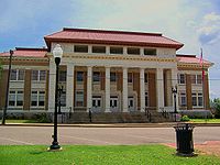 |
Roughly, along Main and Liberty Sts. between Reynolds and 8th Sts. 34°14′44"N 88°59′53"W |
Pontotoc Pontotoc, Mississippi Pontotoc is a city in Pontotoc County, Mississippi, United States. Pontotoc is west of the much larger city of Tupelo. The population was 5,625 at the 2010 census... |
||
| 3 | Treaty of Pontotoc Site | Address Restricted | Pontotoc Pontotoc, Mississippi Pontotoc is a city in Pontotoc County, Mississippi, United States. Pontotoc is west of the much larger city of Tupelo. The population was 5,625 at the 2010 census... |
Prentiss CountyPrentiss County, Mississippi-Demographics:As of the census of 2000, there were 25,556 people, 9,821 households, and 7,169 families residing in the county. The population density was 62 people per square mile . There were 10,681 housing units at an average density of 26 per square mile...
| Landmark name | Image | Date listed | Location | City or Town | Summary | |
|---|---|---|---|---|---|---|
| 1 | Downtown Booneville Historic District | Roughly bounded by Church, College, Court, 1st, Hotel, Main, Market, and Mill Sts. 34°39′21"N 88°33′48"W |
Booneville Booneville, Mississippi Booneville is a city in Prentiss County, Mississippi, United States. The population was 8,625 at the 2000 census. It is the county seat of Prentiss County.... |
|||
| 2 | Pharr Mounds Pharr Mounds Pharr Mounds is a Middle Woodland period archaeological site located near Tupelo in parts of Itawamba and Prentiss County in northern Mississippi.... |
Mile 286.7 on the Natchez Trace Parkway Natchez Trace Parkway The Natchez Trace Parkway is a National Park Service unit in the southeastern United States that commemorates the historic Old Natchez Trace and preserves sections of the original trail.... 34°27′58.1"N 88°24′58"W |
Kirkville | Extends into Itawamba County |
Quitman CountyQuitman County, Mississippi-Demographics:As of the census of 2000, there were 10,117 people, 3,565 households, and 2,506 families residing in the county. The population density was 25 people per square mile . There were 3,923 housing units at an average density of 10 per square mile...
| Landmark name | Image | Date listed | Location | City or Town | Summary | |
|---|---|---|---|---|---|---|
| 1 | Denton Site | Address Restricted | Denton Denton, Mississippi Denton is an unincorporated community in Quitman County, Mississippi, United States. Denton is located on Mississippi Highway 3 south of Lambert.... |
|||
| 2 | Norman Site | Address Restricted | Lambert Lambert, Mississippi Lambert is a town in Quitman County, Mississippi, United States. The population was 1,967 at the 2000 census.-Geography:Lambert is located at .According to the United States Census Bureau, the town has a total area of , all land.... |
|||
| 3 | Posey Site (22QU500) | Address Restricted | Marks Marks, Mississippi Marks is a city in Quitman County, Mississippi, United States. As of the 2000 census, the city population was 1,551. It is the county seat of Quitman County... |
|||
| 4 | Shady Grove Site (22QU525) | Address Restricted | Marks Marks, Mississippi Marks is a city in Quitman County, Mississippi, United States. As of the 2000 census, the city population was 1,551. It is the county seat of Quitman County... |
Rankin CountyRankin County, Mississippi-Demographics:As of the census of 2000, there were 115,327 people, 42,089 households, and 31,145 families residing in the county. The population density was 149 people per square mile . There were 45,070 housing units at an average density of 58 per square mile...
Scott CountyScott County, Mississippi-Demographics:As of the census of 2000, there were 28,423 people, 10,183 households, and 7,535 families residing in the county. The population density was 47 people per square mile . There were 11,116 housing units at an average density of 18 per square mile...
| Landmark name | Image | Date listed | Location | City or Town | Summary | |
|---|---|---|---|---|---|---|
| 1 | Lake Railroad Station | Brook St. 32°20′35"N 89°19′42"W |
Lake Lake, Mississippi Lake is a town in Newton and Scott Counties in the U.S. state of Mississippi. The population was 408 at the 2000 census. Lake is the birthplace of country music singer, Randy Houser.-Geography:... |
|||
| 2 | Moore Lookout Tower | County Road 503 32°19′7"N 89°29′49"W |
Forest Forest, Mississippi Forest is a city in Scott County, Mississippi, United States. The population was 5,987 at the 2000 census. It is the county seat of Scott County.-Geography:Forest is located at .... |
|||
| 3 | Roosevelt State Park Roosevelt State Park Roosevelt State Park is a U.S. state park in Mississippi. It is located off I-20 near Morton, between Jackson and Meridian. Area AttractionsThe following attractions are located within a short drive of Roosevelt State Park.* Bienville National Forest... |
2149 Mississippi Highway 13, S. 32°18′49"N 89°40′45"W |
Morton Morton, Mississippi Morton is a city in Scott County, Mississippi, United States. The population was 3,482 at the 2000 census.-Geography:Morton is located at .... |
|||
| 4 | US Post Office-Forest | 119 2nd St. 32°21′45"N 89°28′21"W |
Forest Forest, Mississippi Forest is a city in Scott County, Mississippi, United States. The population was 5,987 at the 2000 census. It is the county seat of Scott County.-Geography:Forest is located at .... |
Sharkey CountySharkey County, Mississippi-National protected area:*Delta National Forest*Theodore Roosevelt National Wildlife Refuge -Demographics:As of the census of 2000, there were 6,580 people, 2,163 households, and 1,589 families residing in the county. The population density was 15 people per square mile . There were 2,416 housing...
| Landmark name | Image | Date listed | Location | City or Town | Summary | |
|---|---|---|---|---|---|---|
| 1 | Cary Site (22Sh507) | Address Restricted | Cary Cary, Mississippi Cary is a town in Sharkey County, Mississippi, United States. The population was 427 at the 2000 census.-Geography:According to the United States Census Bureau, the town has a total area of , all of it land.-Demographics:... |
|||
| 2 | Leist A Site (22Sh520;22N1) | Address Restricted | Rolling Fork Rolling Fork, Mississippi Rolling Fork is a city in Sharkey County, Mississippi, United States. The population was 2,486 at the 2000 census. It is the county seat of Sharkey County.-Geography:Rolling Fork is located at .... |
|||
| 3 | Rolling Fork Mounds | Southwest of Rolling Fork 32°53′47"N 90°52′44"W |
Rolling Fork Rolling Fork, Mississippi Rolling Fork is a city in Sharkey County, Mississippi, United States. The population was 2,486 at the 2000 census. It is the county seat of Sharkey County.-Geography:Rolling Fork is located at .... |
|||
| 4 | Savory Site (22-Sh-518) | Address Restricted | Holly Bluff Holly Bluff, Mississippi The Village of Holly Bluff is a small unincorporated community in Yazoo County, Mississippi, United States, in the Mississippi Delta.Originally known as "Sharbrough's Landing" to river boat pilots the community was established by the Sharbrough family in 1877... |
|||
| 5 | Spanish Fort Site (22SH500) | Address Restricted | Holly Bluff Holly Bluff, Mississippi The Village of Holly Bluff is a small unincorporated community in Yazoo County, Mississippi, United States, in the Mississippi Delta.Originally known as "Sharbrough's Landing" to river boat pilots the community was established by the Sharbrough family in 1877... |
Simpson CountySimpson County, Mississippi-Demographics:As of the census of 2000, there were 27,639 people, 10,076 households, and 7,385 families residing in the county. The population density was 47 people per square mile . There were 11,307 housing units at an average density of 19 per square mile...
| Landmark name | Image | Date listed | Location | City or Town | Summary | |
|---|---|---|---|---|---|---|
| 1 | Gatesville Bridge | Spans the Pearl River Pearl River (Mississippi-Louisiana) The Pearl River is a river in the U.S. states of Mississippi and Louisiana. It forms in Neshoba County, Mississippi from the confluence of Nanih Waiya and Tallahaga creeks. It is long. The Yockanookany and Strong rivers are tributaries. Northeast of Jackson, the Ross Barnett Reservoir is formed by... on a county road east of Gatesville 31°59′46"N 90°13′26"W |
Pearl Pearl, Mississippi Pearl is a city in Rankin County, Mississippi, United States. The population was 21,961 at the 2000 census. It is part of the Jackson Metropolitan Statistical Area.... |
Extends into Copiah County National Register of Historic Places listings in Copiah County, Mississippi This is a list of the National Register of Historic Places listings in Copiah County, Mississippi.This is intended to be a complete list of the properties and districts on the National Register of Historic Places in Copiah County, Mississippi, United States... |
||
| 2 | L'Dora Lewis Mound (22SI512) | Address Restricted | Pearl Pearl, Mississippi Pearl is a city in Rankin County, Mississippi, United States. The population was 21,961 at the 2000 census. It is part of the Jackson Metropolitan Statistical Area.... |
|||
| 3 | Simpson County Courthouse |  |
Courthouse Square 31°57′46"N 89°52′10"W |
Mendenhall |
Smith CountySmith County, Mississippi-Demographics:As of the census of 2000, there were 16,182 people, 6,046 households, and 4,558 families residing in the county. The population density was 25 people per square mile . There were 7,005 housing units at an average density of 11 per square mile...
| Landmark name | Image | Date listed | Location | City or Town | Summary | |
|---|---|---|---|---|---|---|
| 1 | Taylorsville Signal Office and Watkins General Store | 326 Eureka St. 31°49′42"N 89°25′39"W |
Taylorsville Taylorsville, Mississippi Taylorsville is a town in Smith County, Mississippi, United States. It is the hometown of various professional athletes, including former Auburn Tigers and current Oakland Raiders quarterback Jason Campbell... |
Stone CountyStone County, MississippiAs of the census of 2000, there were 13,622 people, 4,747 households, and 3,626 families residing in the county. The population density was 31 people per square mile . There were 5,343 housing units at an average density of 12 per square mile...
| Landmark name | Image | Date listed | Location | City or Town | Summary | |
|---|---|---|---|---|---|---|
| 1 | George Austin McHenry House | McHenry Avenue at 5th Street 30°42′29"N 89°8′18"W |
McHenry McHenry, Mississippi McHenry, Mississippi, is an unincorporated community in southern Stone County. It is situated approximately 10 miles south of Wiggins and 3 miles north of Saucier. The community is part of the Gulfport-Biloxi metropolitan area.... |
Constructed 1895-1901, private residence |
Sunflower CountySunflower County, Mississippi-Demographics:As of the census of 2000, there were 34,369 people, 9,637 households, and 7,314 families residing in the county. The population density was 50 people per square mile . There were 10,338 housing units at an average density of 15 per square mile...
| Landmark name | Image | Date listed | Location | City or Town | Summary | |
|---|---|---|---|---|---|---|
| 1 | Dockery Farms Historic District |  |
Mississippi Highway 8, E. 33°43′44"N 90°36′46"W |
Dockery Dockery, Mississippi Dockery is an unincorporated community located in Sunflower County, Mississippi. Dockery is located on Mississippi Highway 8 and approximately west of Mississippi and east of Ruleville.The historical Dockery Plantation is located in Dockery.... |
||
| 2 | Indianola Historic District | Roughly bounded by Percy St. on the north, Front to Adair on the west to Roosevelt, Roosevelt east to Front Extended and north 33°27′1.89"N 90°39′6.03"W |
Indianola Indianola, Mississippi Indianola is a city in Sunflower County, Mississippi, United States. The population was 12,066 at the 2000 census. It is the county seat of Sunflower County.-History:... |
|||
| 3 | Ruleville Depot | Eastern side of the railroad tracks at the junction of E. Floyce St. and N. Front St. 33°43′38"N 90°33′9"W |
Ruleville Ruleville, Mississippi Ruleville is a small city in the fertile Mississippi Delta region in Sunflower County, Mississippi, United States. The population was 3,234 at the 2000 census.-Geography:Ruleville is located at .... |
|||
| 4 | Woodburn Bridge | Spans the Big Sunflower River Sunflower River The Sunflower River is one of the main tributaries of the Yazoo River in the U.S. state of Mississippi. It is navigable by barge for 50 miles. It rises in De Soto County, Mississippi near the Tennessee border and flows south for 100 miles to the Yazoo River... on a county road southeast of Indianola 33°23′15"N 90°42′21"W |
Indianola Indianola, Mississippi Indianola is a city in Sunflower County, Mississippi, United States. The population was 12,066 at the 2000 census. It is the county seat of Sunflower County.-History:... |
Tallahatchie CountyTallahatchie County, Mississippi-National protected areas:*Coldwater River National Wildlife Refuge *Tallahatchie National Wildlife Refuge -Demographics:As of the census of 2000, there were 14,903 people, 5,263 households, and 3,826 families residing in the county. The population density was 23 people per square mile...
| Landmark name | Image | Date listed | Location | City or Town | Summary | |
|---|---|---|---|---|---|---|
| 1 | Allison Mound (22Tl1024) | Address Restricted | Webb Webb, Mississippi Webb is a town in Tallahatchie County, Mississippi, United States. The population was 587 at the 2000 census.-History:Webb was founded around 1880. The first post office was founded in 1880 and named Hood for one of the earlier settlers. In 1882, Judge James L.A... |
|||
| 2 | Black Bayou Bridge | 2nd St. 33°49′26"N 90°17′38"W |
Glendora Glendora, Mississippi Glendora is a village in Tallahatchie County, Mississippi, United States. The population was 285 at the 2000 census.-History:Glendora started out as a small sawmill site. Logs were floated down the river from around the vicinity of Webb to be sawed there.... |
|||
| 3 | Buford Site (22Tl501) | Address Restricted | Sumner Sumner, Mississippi Sumner is a town in Tallahatchie County, Mississippi, United States. The population was 407 at the 2000 census.-Geography:Sumner is located at .... |
|||
| 4 | Dell Bullion Mound (22Tl998) | Address Restricted | Grenada Grenada, Mississippi Grenada is a city in Grenada County, Mississippi, United States. The population was 14,879 at the 2000 census. It is the county seat of Grenada County.-History:... |
|||
| 5 | Jacks Site | Address Restricted | Philipp Philipp, Mississippi Philipp is an unincorporated community in southern Tallahatchie County, Mississippi along Mississippi Highway 8. Philipp is east of Minter City and west of Holcomb.... |
|||
| 6 | Lamb-Fish Bridge | East of Charleston 34°1′20"N 90°11′32"W |
Charleston Charleston, Mississippi Charleston is a city in North Central Mississippi and one of the county seats of Tallahatchie County. The population was 2,198 at the 2000 census.-Geography:Charleston is located at .... |
|||
| 7 | Murphey-Jennings House | 307 Walnut St. 33°58′1"N 90°22′10"W |
Sumner Sumner, Mississippi Sumner is a town in Tallahatchie County, Mississippi, United States. The population was 407 at the 2000 census.-Geography:Sumner is located at .... |
|||
| 8 | Spivey Site | Address Restricted | Crowder Crowder, Mississippi Crowder is a town in Panola and Quitman Counties in the U.S. state of Mississippi. The population was 766 at the 2000 census.-Geography:Crowder is located at . Most of the town is in Quitman County with a portion on the east in adjacent Panola County... |
|||
| 9 | Tallahatchie County Second District Courthouse | 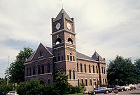 |
108 Main St. 33°58′13"N 90°22′10"W |
Sumner Sumner, Mississippi Sumner is a town in Tallahatchie County, Mississippi, United States. The population was 407 at the 2000 census.-Geography:Sumner is located at .... |
Tate CountyTate County, Mississippi-Demographics:As of the census of 2000, there were 25,370 people, 8,850 households, and 6,717 families residing in the county. The population density was 63 people per square mile . There were 9,354 housing units at an average density of 23 per square mile...
Tippah CountyTippah County, Mississippi-Demographics:At the 2000 census, there are 20,826 people, 8,108 households and 5,910 families residing in the county. The population density was 46 per square mile . There were 8,868 housing units at an average density of 19 per square mile...
| Landmark name | Image | Date listed | Location | City or Town | Summary | |
|---|---|---|---|---|---|---|
| 1 | Blue Mountain College Historic District | Mississippi Highway 15 34°40′24"N 89°1′46"W |
Blue Mountain Blue Mountain, Mississippi Blue Mountain is a town in Tippah County, Mississippi, United States. The population was 670 at the 2000 census. It is the location of Blue Mountain College, a private Christian liberal arts college.-Geography:... |
|||
| 2 | Old US Post Office-Ripley | 301 N. Main St. 34°43′54"N 88°56′58"W |
Ripley Ripley, Mississippi Ripley is a city in Tippah County, Mississippi, United States. The population was 5,478 at the 2000 census. It is the county seat of Tippah County.... |
|||
| 3 | Ripley Historic District Ripley Historic District (Ripley, Mississippi) Ripley Historic District in Ripley, Mississippi includes something built in 1837. It was listed on the National Register of Historic Places in 2005.... |
Roughly bounded by North St., Siddall St., MS, and Middle St. 34°43′53"N 88°57′0"W |
Ripley Ripley, Mississippi Ripley is a city in Tippah County, Mississippi, United States. The population was 5,478 at the 2000 census. It is the county seat of Tippah County.... |
Tishomingo CountyTishomingo County, MississippiAs of the census of 2000 there were 19,163 people, 7,917 households, and 5,573 families residing in the county. The population density was 45 people per square mile . There were 9,553 housing units at an average density of 22 per square mile...
Tunica CountyTunica County, MississippiAs of the census of 2000, there were 9,227 people, 3,258 households, and 2,192 families residing in the county. The population density was 20 people per square mile . There were 3,705 housing units at an average density of 8 per square mile...
| Landmark name | Image | Date listed | Location | City or Town | Summary | |
|---|---|---|---|---|---|---|
| 1 | Beaverdam Site | Address Restricted | Evansville Evansville, Mississippi Evansville is an unincorporated community in Tunica County, Mississippi, United States. Evansville is approximately south of Tunica and approximately west of White Oak-References:... |
|||
| 2 | Canon Site (22-Tu-523) | Address Restricted | Crenshaw Crenshaw, Mississippi Crenshaw is a town in Panola and Quitman Counties in the U.S. state of Mississippi. The population was 916 at the 2000 census.-Geography:Crenshaw is located at . Most of the town is in Panola County with a small portion on the west side in adjacent Quitman County... |
|||
| 3 | Dundee Site (22TU501) | Address Restricted | Dundee Dundee, Mississippi Dundee is an unincorporated community in Tunica County, Mississippi, United States. Dundee is south-southwest of Tunica. Dundee has a post office with ZIP code 38626.-Education:... |
|||
| 4 | Evansville Mounds (22TU502) | Address Restricted | Evansville Evansville, Mississippi Evansville is an unincorporated community in Tunica County, Mississippi, United States. Evansville is approximately south of Tunica and approximately west of White Oak-References:... |
|||
| 5 | Hollywood Site | Address Restricted | Tunica Tunica, Mississippi Tunica is a town in Tunica County, Mississippi, United States, located near the Mississippi River. Until the early 1990s the town was one of the most impoverished places in the United States, semi-famous for the particularly deprived neighbourhood known as "Sugar Ditch Alley", named for the open... |
|||
| 6 | Johnson Cemetery Site (22TU516) | Address Restricted | Hollywood Hollywood, Mississippi Hollywood is an unincorporated community located near U.S. Highway 61 in Tunica County, Mississippi, United States. It is approximately north of North Tunica, Mississippi, approximately north Tunica, Mississippi, and approximately south of Memphis, Tennessee.... |
|||
| 7 | Owens Site (22TU512) | Address Restricted | Evansville Evansville, Mississippi Evansville is an unincorporated community in Tunica County, Mississippi, United States. Evansville is approximately south of Tunica and approximately west of White Oak-References:... |
|||
| 8 | Tunica Historic District | Roughly bounded by Kestevan Alley, Mockingbird St., Cummins Ave., and the Tunica School 34°41′12"N 90°22′28"W |
Tunica Tunica, Mississippi Tunica is a town in Tunica County, Mississippi, United States, located near the Mississippi River. Until the early 1990s the town was one of the most impoverished places in the United States, semi-famous for the particularly deprived neighbourhood known as "Sugar Ditch Alley", named for the open... |
Union CountyUnion County, Mississippi-Demographics:As of the census of 2000, there were 25,362 people, 9,786 households, and 7,241 families residing in the county. The population density was 61 people per square mile . There were 10,693 housing units at an average density of 26 per square mile...
| Landmark name | Image | Date listed | Location | City or Town | Summary | |
|---|---|---|---|---|---|---|
| 1 | Ingomar Mound | Address Restricted | Ingomar | |||
| 2 | New Albany Downtown Historic District | Roughly bounded by W. and E. Main, Camp St., and the former St. Louis – San Francisco railroad tracks 34°29′38"N 89°0′31"W |
New Albany New Albany, Mississippi New Albany is a city in Union County, Mississippi, United States. The population was 8,526 at the 2010 census. New Albany is the county seat of Union County. New Albany was first organized in 1840 at the site of a grist mill and saw mill on the Tallahatchie River and was developed as a river port... |
|||
| 3 | Union County Courthouse | Bankhead St. between Court and Camp Aves. 34°29′33"N 89°0′26"W |
New Albany New Albany, Mississippi New Albany is a city in Union County, Mississippi, United States. The population was 8,526 at the 2010 census. New Albany is the county seat of Union County. New Albany was first organized in 1840 at the site of a grist mill and saw mill on the Tallahatchie River and was developed as a river port... |
Walthall CountyWalthall County, Mississippi-Demographics:As of the census of 2000, there were 15,156 people, 5,571 households, and 4,111 families residing in the county. The population density was 38 people per square mile . There were 6,418 housing units at an average density of 16 per square mile...
| Landmark name | Image | Date listed | Location | City or Town | Summary | |
|---|---|---|---|---|---|---|
| 1 | China Grove Methodist Church China Grove Methodist Church China Grove Methodist Church is a historic church at Tylertown, Mississippi.It was built in 1861 and added to the National Register in 1984.... |
Mississippi Highway 585 31°12′33"N 90°3′28"W |
Tylertown Tylertown, Mississippi Tylertown is the county seat of Walthall County, Mississippi, United States. The population was 1,910 at the 2000 census.-History:Tylertown was first known as the Magee Settlement. Its first settlement dates back to the emigration of the Magees and Thornhills from South Carolina and is located on a... |
|||
| 2 | George H. Collins House | 615 Union Rd. 31°7′23"N 90°8′26"W |
Tylertown Tylertown, Mississippi Tylertown is the county seat of Walthall County, Mississippi, United States. The population was 1,910 at the 2000 census.-History:Tylertown was first known as the Magee Settlement. Its first settlement dates back to the emigration of the Magees and Thornhills from South Carolina and is located on a... |
|||
| 3 | New Orleans and Great Northern Railroad Depot-Tylertown | Franklin Highway 31°6′54"N 90°8′26"W |
Tylertown Tylertown, Mississippi Tylertown is the county seat of Walthall County, Mississippi, United States. The population was 1,910 at the 2000 census.-History:Tylertown was first known as the Magee Settlement. Its first settlement dates back to the emigration of the Magees and Thornhills from South Carolina and is located on a... |
|||
| 4 | Walthall County Courthouse and Jail | 200 Ball Ave. 31°7′0"N 90°8′29"W |
Tylertown Tylertown, Mississippi Tylertown is the county seat of Walthall County, Mississippi, United States. The population was 1,910 at the 2000 census.-History:Tylertown was first known as the Magee Settlement. Its first settlement dates back to the emigration of the Magees and Thornhills from South Carolina and is located on a... |
Warren CountyWarren County, Mississippi-National protected areas:* Theodore Roosevelt National Wildlife Refuge * Vicksburg National Military Park -Demographics:As of the census of 2000, there were 49,644 people, 18,756 households, and 13,222 families residing in the county. The population density was 85 people per square mile...
Washington CountyWashington County, Mississippi-National protected areas:*Holt Collier National Wildlife Refuge*Theodore Roosevelt National Wildlife Refuge *Yazoo National Wildlife Refuge-Demographics:...
Wayne CountyWayne County, Mississippi-Demographics:As of the census of 2000, there were 21,216 people, 7,857 households, and 5,853 families residing in the county. The population density was 26 people per square mile . There were 9,049 housing units at an average density of 11 per square mile...
| Landmark name | Image | Date listed | Location | City or Town | Summary | |
|---|---|---|---|---|---|---|
| 1 | Yellow Creek Bridge | Spans Yellow Creek on a county road northwest of Waynesboro 31°41′49"N 88°40′13"W |
Waynesboro Waynesboro, Mississippi Waynesboro is a city in Wayne County, Mississippi, United States. The population was 5,197 at the 2000 census. It is the county seat of Wayne County.-Geography:Waynesboro is located at , just east of the Chickasawhay River.... |
Webster CountyWebster County, Mississippi-Demographics:As of the census of 2000, there were 10,294 people, 3,905 households, and 2,877 families residing in the county. The population density was 24 people per square mile . There were 4,344 housing units at an average density of 10 per square mile...
| Landmark name | Image | Date listed | Location | City or Town | Summary | |
|---|---|---|---|---|---|---|
| 1 | Eupora Historic District | Roughly along N. Dunn St. & W. Roane Ave. 33°32′27"N 89°16′7"W |
Eupora Eupora, Mississippi Eupora is a city in Webster County, Mississippi, United States. The population was 2,326 at the 2000 census.-Geography:Eupora is located at .... |
|||
| 2 | Wood Home for Boys | Horton St. 33°32′42"N 89°7′32"W |
Mathiston Mathiston, Mississippi Mathiston is a town in Choctaw and Webster Counties in the U.S. state of Mississippi. The population was 720 at the 2000 census.-Geography:Mathiston is located at . Most of the town is in Webster County with a portion on the south side extending into Choctaw County... |
Wilkinson CountyWilkinson County, Mississippi-Demographics:As of the census of 2000, there were 10,312 people, 3,578 households, and 2,511 families residing in the county. The population density was 15 people per square mile . There were 5,106 housing units at an average density of 8 per square mile...
Winston CountyWinston County, Mississippi-Demographics:At the 2000 census, there were 20,160 people, 7,578 households and 5,471 families residing in the county. The population density was 33 per square mile . There were 8,472 housing units at an average density of 14 per square mile...
| Landmark name | Image | Date listed | Location | City or Town | Summary | |
|---|---|---|---|---|---|---|
| 1 | Baptist Church of Christ at Sardis | Sardis Rd. 33°3′20"N 88°51′13"W |
Louisville Louisville, Mississippi Louisville is a city in Winston County, Mississippi, United States. The population was 7,006 at the 2000 census. It is the county seat of Winston County.-Geography:Louisville is located at .... vicinity |
|||
| 2 | Downtown Louisville Historic District | Bounded by Church St., W. Park St., Columbus Ave. & Mill St. 33°7′25"N 89°3′16"W |
Louisville Louisville, Mississippi Louisville is a city in Winston County, Mississippi, United States. The population was 7,006 at the 2000 census. It is the county seat of Winston County.-Geography:Louisville is located at .... |
|||
| 3 | Foster-Fair House | 507 S. Columbus Ave. 33°7′4"N 89°3′9"W |
Louisville Louisville, Mississippi Louisville is a city in Winston County, Mississippi, United States. The population was 7,006 at the 2000 census. It is the county seat of Winston County.-Geography:Louisville is located at .... |
|||
| 4 | Legion State Park Legion State Park Legion State Park, also known as Legion State Park Historic District, is located in the red hill country of Louisville, Mississippi, and area originally inhabited by the Choctaw Indian Nation... |
635 Legion State Park Rd. 33°9′5"N 89°2′41"W |
Louisville Louisville, Mississippi Louisville is a city in Winston County, Mississippi, United States. The population was 7,006 at the 2000 census. It is the county seat of Winston County.-Geography:Louisville is located at .... |
|||
| 5 | Old Masonic Hall Old Masonic Hall (Louisville, Mississippi) The Old Masonic Hall in Louisville, Mississippi, also known as Community House, as Chamber of Commerce, and as Louisville Lodge No. 75, F&AM, is a historic building built in 1851... |
311 W. Park St. 33°7′19"N 89°3′22"W |
Louisville Louisville, Mississippi Louisville is a city in Winston County, Mississippi, United States. The population was 7,006 at the 2000 census. It is the county seat of Winston County.-Geography:Louisville is located at .... |
|||
| 6 | Nanih Waiya Mound And Village Nanih Waiya Nanih Waiya is an ancient earthwork mound in Winston County, Mississippi, constructed by indigenous people during the Middle Woodland period, about 0-300 CE. Since the 17th century, the historic Choctaw have venerated Nanih Waiya as their sacred origin location in traditional beliefs.Today the... |
 |
Along Mississippi Highway 393 in Nanih Waiya State Park 32°55′15"N 88°56′55"W |
Fearns Springs | ||
| 7 | Old Robinson Road | 16.6 miles northeast of Louisville in the Noxubee National Wildlife Refuge Noxubee National Wildlife Refuge Noxubee National Wildlife Refuge is a National Wildlife Refuge located in the U.S. state of Mississippi, in Noxubee, Oktibbeha, and Winston Counties . The refuge serves as a resting and feeding area for migratory birds and as example of proper land stewardship... 33°16′32"N 88°49′52"W |
Louisville Louisville, Mississippi Louisville is a city in Winston County, Mississippi, United States. The population was 7,006 at the 2000 census. It is the county seat of Winston County.-Geography:Louisville is located at .... |
|||
| 8 | Benjamin Franklin Smyth House | 207 Smyth Rd. 33°5′52"N 89°4′24"W |
Louisville Louisville, Mississippi Louisville is a city in Winston County, Mississippi, United States. The population was 7,006 at the 2000 census. It is the county seat of Winston County.-Geography:Louisville is located at .... |
Yalobusha CountyYalobusha County, MississippiYalobusha County is a county located in the U.S. state of Mississippi. As of 2010, the population was 12,678. Its county seats are Water Valley and Coffeeville.-History:...
| Landmark name | Image | Date listed | Location | City or Town | Summary | |
|---|---|---|---|---|---|---|
| 1 | US Post Office-Water Valley | 2322 Main St. 34°9′9"N 89°38′7"W |
Water Valley Water Valley, Mississippi Water Valley is a city in Yalobusha County, Mississippi, United States. The population was 3,677 at the 2000 census.-Geography:Water Valley is located at .... |