

Leaf River (Mississippi)
Encyclopedia
The Leaf River is a river
, about 180 mi (290 km) long, in southern Mississippi
in the United States
. It is a principal tributary
of the Pascagoula River
, which flows to the Gulf of Mexico
.
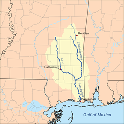 The Leaf River rises in the Bienville National Forest
in southwestern Scott County
and flows initially southward through eastern Smith
, northeastern Covington
, western Jones
and northern Forrest
Counties to Hattiesburg
, where it collects the Bouie River
. Below Hattiesburg, the river turns southeastward and flows through central Perry
and southwestern Greene
Counties, skirting the edge of the De Soto National Forest
, into northern George County
, where it joins the Chickasawhay River
to form the Pascagoula River.
. Legend says that one of these traders buried his profits, several thousand dollars in Spanish coins, near the banks of the Leaf River. The coins were later found in about 1854.
, the Leaf River has also been known as:
River
A river is a natural watercourse, usually freshwater, flowing towards an ocean, a lake, a sea, or another river. In a few cases, a river simply flows into the ground or dries up completely before reaching another body of water. Small rivers may also be called by several other names, including...
, about 180 mi (290 km) long, in southern Mississippi
Mississippi
Mississippi is a U.S. state located in the Southern United States. Jackson is the state capital and largest city. The name of the state derives from the Mississippi River, which flows along its western boundary, whose name comes from the Ojibwe word misi-ziibi...
in the United States
United States
The United States of America is a federal constitutional republic comprising fifty states and a federal district...
. It is a principal tributary
Tributary
A tributary or affluent is a stream or river that flows into a main stem river or a lake. A tributary does not flow directly into a sea or ocean...
of the Pascagoula River
Pascagoula River
The Pascagoula River is a river, about 80 mi long, in southeastern Mississippi in the United States. The river drains an area of about 8,800 sq mi and flows into Mississippi Sound of the Gulf of Mexico....
, which flows to the Gulf of Mexico
Gulf of Mexico
The Gulf of Mexico is a partially landlocked ocean basin largely surrounded by the North American continent and the island of Cuba. It is bounded on the northeast, north and northwest by the Gulf Coast of the United States, on the southwest and south by Mexico, and on the southeast by Cuba. In...
.
Course
Bienville National Forest
Bienville National Forest is a United States National Forest in central Mississippi. It is named for Jean-Baptiste Le Moyne de Bienville. In descending order of land area it lies in parts of Scott, Smith, Jasper, and Newton counties. It has an area of 178,542 acres...
in southwestern Scott County
Scott County, Mississippi
-Demographics:As of the census of 2000, there were 28,423 people, 10,183 households, and 7,535 families residing in the county. The population density was 47 people per square mile . There were 11,116 housing units at an average density of 18 per square mile...
and flows initially southward through eastern Smith
Smith County, Mississippi
-Demographics:As of the census of 2000, there were 16,182 people, 6,046 households, and 4,558 families residing in the county. The population density was 25 people per square mile . There were 7,005 housing units at an average density of 11 per square mile...
, northeastern Covington
Covington County, Mississippi
-2010 Census:As of the most recent census, 2010, the population of Covington County is 19,568, only a slight increase from 2000. Racially, the population was distributed with 62.7% being White, 34.7% Black/African American, 1.9% Hispanic/Latino, 0.2% Asian, 0.1% American Indian/Alaskan Native, and...
, western Jones
Jones County, Mississippi
-History:Jones County, formed out parts of Covington and Wayne counties, was established on January 24, 1826 and was named for John Paul Jones. There are other counties named Jones, but it appears that this is the only one named for John Paul Jones...
and northern Forrest
Forrest County, Mississippi
The median income for a household in the county was $27,420, and the median income for a family was $35,791. Males had a median income of $28,742 versus $20,500 for females. The per capita income for the county was $15,160...
Counties to Hattiesburg
Hattiesburg, Mississippi
Hattiesburg is a city in Forrest County, Mississippi, United States. The population was 44,779 at the 2000 census . It is the county seat of Forrest County...
, where it collects the Bouie River
Bouie River
The Bouie River, also sometimes known as the Bowie River, is a tributary of the Leaf River, 60 mi long, in southern Mississippi in the United States...
. Below Hattiesburg, the river turns southeastward and flows through central Perry
Perry County, Mississippi
-Demographics:As of the census of 2000, there were 12,138 people, 4,420 households, and 3,332 families residing in the county. The population density was 19 people per square mile . There were 5,107 housing units at an average density of 8 per square mile...
and southwestern Greene
Greene County, Mississippi
-Demographics:As of the census of 2000, there were 13,299 people, 4,148 households, and 3,152 families residing in the county. The population density was 19 people per square mile . There were 4,947 housing units at an average density of 7 per square mile...
Counties, skirting the edge of the De Soto National Forest
De Soto National Forest
De Soto National Forest is of pine forests in southern Mississippi. It offers year-round opportunities for outdoor activities including camping, canoeing, hunting, fishing, and more. There are two wilderness areas within DeSoto: Black Creek Wilderness and Leaf River Wilderness...
, into northern George County
George County, Mississippi
-Demographics:As of the census of 2000, there were 19,144 people, 6,742 households, and 5,305 families residing in the county. The population density was 40 people per square mile . There were 7,513 housing units at an average density of 16 per square mile...
, where it joins the Chickasawhay River
Chickasawhay River
The Chickasawhay River is a river, about long, in southeastern Mississippi in the United States. It is a principal tributary of the Pascagoula River, which flows to the Gulf of Mexico. The Chickasawhay's tributaries also drain a portion of western Alabama...
to form the Pascagoula River.
History
The Leaf River served as a trade route in the area before roads and trails were widely developed. It is recorded that traders made regular trips to people living near the river bringing with them supplies from PascagoulaPascagoula, Mississippi
Pascagoula is a city in Jackson County, Mississippi, United States. It is the principal city of the Pascagoula, Mississippi Metropolitan Statistical Area, as a part of the Gulfport–Biloxi–Pascagoula, Mississippi Combined Statistical Area. The population was 26,200 at the 2000 census...
. Legend says that one of these traders buried his profits, several thousand dollars in Spanish coins, near the banks of the Leaf River. The coins were later found in about 1854.
Alleged pollution
While the upper stretches of the river enjoy an excellent reputation, the lower river has been the subject of claims of pollution since the 1990s. At that time, thousands of area residents filed suit against the Georgia-Pacific Corporation, claiming that its pulp mill released the dangerous chemical, dioxin, into the river. In 1996, these suits were dismissed when the courts decided that there was no scientific proof that dangerous dioxin levels were present in the river or that Georgia-Pacific was negligent.Variant names
According to the Geographic Names Information SystemGeographic Names Information System
The Geographic Names Information System is a database that contains name and locative information about more than two million physical and cultural features located throughout the United States of America and its territories. It is a type of gazetteer...
, the Leaf River has also been known as:
- Estapacha River
- Estopacha River
- Fiume
- Hashuphatchee River
- Hastabucha River
- Hastehatchee River
- Leaf Creek
- Pescaooula River (in part)
- Slapacha River
- Tallahoma River (in part)
- Tally Hooma Creek (in part)