

List of National Natural Landmarks in Missouri
Encyclopedia
From List of National Natural Landmarks, these are the National Natural Landmark
s in Missouri
. There are 16 in total, X are lakes or pond, Y are forests, Z are other.
{|class="wikitable sortable" align="center"
!
! Name
! Image
! Date
! Location
! County
! Description
|-
| 1
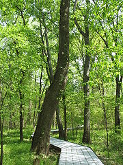
| Big Oak Tree State Park
|
|
| East Prairie
36.655°N 89.32833°W
| Mississippi
| A rare untouched wet-mesic bottomland hardwood forest
in the Mississippi Alluvial Plain
, it is the home of several state and national champion trees
|-
| 2
| Carroll Cave
|
|
|
| Camden
| Dontains a dendritic system of subsurface karst streams and tributaries.
|-
| 3
| Cupola Pond
|
|
|
| Ripley
| One of the most ancient sinkhole ponds in the Ozark plateaus.
|-
| 4
| Golden Prairie
|
|
|
| Barton
| An essentially virgin tall grass prairie ecosystem.
|-
| 5
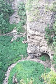
| Grand Gulf State Park
|
|
| Thayer
36.52427°N 91.54389°W
| Oregon
| An excellent example of karst topography
, this canyon is a collapsed dolomite
cave with a
From List of National Natural Landmarks, these are the National Natural Landmark
s in Missouri
. There are 16 in total, X are lakes or pond, Y are forests, Z are other.
{|class="wikitable sortable" align="center"
!
! Name
! Image
! Date
! Location
! County
! Description
|-
| 1
| Big Oak Tree State Park
|
|
| East Prairie
36.655°N 89.32833°W
| Mississippi
| A rare untouched wet-mesic bottomland hardwood forest
in the Mississippi Alluvial Plain
, it is the home of several state and national champion trees
|-
| 2
| Carroll Cave
|
|
|
| Camden
| Dontains a dendritic system of subsurface karst streams and tributaries.
|-
| 3
| Cupola Pond
|
|
|
| Ripley
| One of the most ancient sinkhole ponds in the Ozark plateaus.
|-
| 4
| Golden Prairie
|
|
|
| Barton
| An essentially virgin tall grass prairie ecosystem.
|-
| 5
| Grand Gulf State Park
|
|
| Thayer
36.52427°N 91.54389°W
| Oregon
| An excellent example of karst topography
, this canyon is a collapsed dolomite
cave with a {200 feet (61 m) natural bridge
. Water in this canyon emerges 9 miles (14.5 km) away in Mammoth Spring
, Arkansas
.
|-
| 6
| Greer Spring
|
|
|
| Oregon
| Spring in the Ozarks that discharges into a high quality, cascading stream.
|-
| 7
| Maple Woods Natural Area
|
|
|
| Clay
| Contains a nearly virgin sugar maple and mockernut hickory forest.
|-
| 8
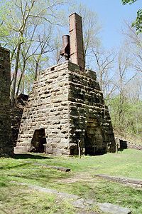
| Maramec Spring
|
|
| St. James
37.95526°N 91.53632°W
| Phelps
| A natural spring
, the fifth largest in the state. It has a notable trout park and a historic iron works in a privately owned park.
|-
| 9
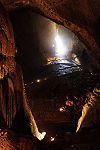
| Mark Twain and Cameron Caves
|
|
|
| Marion
| Exceptionally good examples of the maze type of cavern development.
|-
| 10
| Marvel Cave
|
|
|
| Stone
| Includes one of the greatest dripstone units of all the Ozark caves.
|-
| 11
| Onondaga Cave
|
|
|
| Crawford
| Contains an unusually large and varied number of speleothems.
|-
| 12
| Pickle Springs
|
|
|
| Ste. Genevieve
| Contains one of the finest Pleistocene relict habitats in Missouri.
|-
| 13
| Taberville Prairie
|
|
|
| St. Clair
| One of the largest remaining virgin tall grass prairies.
|-
| 14
| Tucker Prairie
|
|
|
| Callaway
| A virgin tall grass prairie occurring within the transition zone between the oak-hickory forest and typical tall grass prairie.
|-
| 15
| Tumbling Creek Cave
|
|
|
| Taney
| Contains the most diverse fauna known for any cave west of the Mississippi River.
|-
| 16
| Wegener Woods
|
|
|
| Warren
| An essentially virgin oak-hickory-dominated forest in a condition of gradual change to a sugar maple-dominated forest.
|-
|}
National Natural Landmark
The National Natural Landmark program recognizes and encourages the conservation of outstanding examples of the natural history of the United States. It is the only natural areas program of national scope that identifies and recognizes the best examples of biological and geological features in...
s in Missouri
Missouri
Missouri is a US state located in the Midwestern United States, bordered by Iowa, Illinois, Kentucky, Tennessee, Arkansas, Oklahoma, Kansas and Nebraska. With a 2010 population of 5,988,927, Missouri is the 18th most populous state in the nation and the fifth most populous in the Midwest. It...
. There are 16 in total, X are lakes or pond, Y are forests, Z are other.
{|class="wikitable sortable" align="center"
!
! Name
! Image
! Date
! Location
! County
! Description
|-
| 1
| Big Oak Tree State Park
Big Oak Tree State Park
The Big Oak Tree State Park is a park located in East Prairie, Missouri, United States. It was established in 1937 to help preserve some of the largest trees in the state and in the nation in a region of farmland. Activities in the park include fishing, hiking, and picnicking. An accessible...
|
|
| East Prairie
East Prairie, Missouri
East Prairie is a city in Mississippi County, Missouri, United States. The population was 3,227 at the 2000 census. In 1881, the area was originally known as Bell's Grade and Hibbard and developed as a result of the railroad...
36.655°N 89.32833°W
| Mississippi
Mississippi County, Missouri
Mississippi County is a county located in the Bootheel of Southeast Missouri in the United States. As of the 2000 U.S. Census, the county's population was 13,427. A 2008 estimate, however, showed the population to be 13,504. The largest city and county seat is Charleston...
| A rare untouched wet-mesic bottomland hardwood forest
Bottomland hardwood forest
The Bottomland hardwood forest is a type of deciduous hardwood forest found in broad lowland floodplains along large rivers and lakes. They are occasionally flooded, which builds up the alluvial soils required for the Gum, Oak and Bald Cypress trees that typically grow in this type of biome...
in the Mississippi Alluvial Plain
Mississippi Alluvial Plain
The Mississippi River Alluvial Plain is an alluvial plain created by the Mississippi River on which lies parts of seven states, from southern Louisiana to southern Illinois....
, it is the home of several state and national champion trees
|-
| 2
| Carroll Cave
|
|
|
| Camden
Camden County, Missouri
Camden County is a county located in the U.S. state of Missouri. As of 2000, the population was 37,051. Its county seat is Camdenton. The county was organized in 1841 as Kinderhook County and renamed in 1843, for Charles Pratt, 1st Earl Camden, Chancellor of England, and leader of the Whig...
| Dontains a dendritic system of subsurface karst streams and tributaries.
|-
| 3
| Cupola Pond
|
|
|
| Ripley
Ripley County, Missouri
Ripley County is a county located in the Ozarks of Southeast Missouri in the United States. As of the 2000 U.S. Census, the county's population was 13,509. A 2008 estimate, however, showed the population to be 13,485. The largest city and county seat is Doniphan...
| One of the most ancient sinkhole ponds in the Ozark plateaus.
|-
| 4
| Golden Prairie
|
|
|
| Barton
| An essentially virgin tall grass prairie ecosystem.
|-
| 5
| Grand Gulf State Park
|
|
| Thayer
Thayer, Missouri
Thayer is a city in Oregon County, Missouri, United States. The population was 2,243 at the 2010 census. Its original name was Augusta.Thayer is considered a railroad town, as it was laid out in 1882 to be a division point. Currently, the Burlington Northern Santa Fe railroad travels through...
36.52427°N 91.54389°W
| Oregon
Oregon County, Missouri
Oregon County is a county located in South Central Missouri in the United States. As of the 2000 U.S. Census, the county's population was 10,344. A 2008 estimate, however, showed the population to be 10,264. Its county seat is Alton...
| An excellent example of karst topography
Karst topography
Karst topography is a geologic formation shaped by the dissolution of a layer or layers of soluble bedrock, usually carbonate rock such as limestone or dolomite, but has also been documented for weathering resistant rocks like quartzite given the right conditions.Due to subterranean drainage, there...
, this canyon is a collapsed dolomite
Dolomite
Dolomite is a carbonate mineral composed of calcium magnesium carbonate CaMg2. The term is also used to describe the sedimentary carbonate rock dolostone....
cave with a
From List of National Natural Landmarks, these are the National Natural Landmark
National Natural Landmark
The National Natural Landmark program recognizes and encourages the conservation of outstanding examples of the natural history of the United States. It is the only natural areas program of national scope that identifies and recognizes the best examples of biological and geological features in...
s in Missouri
Missouri
Missouri is a US state located in the Midwestern United States, bordered by Iowa, Illinois, Kentucky, Tennessee, Arkansas, Oklahoma, Kansas and Nebraska. With a 2010 population of 5,988,927, Missouri is the 18th most populous state in the nation and the fifth most populous in the Midwest. It...
. There are 16 in total, X are lakes or pond, Y are forests, Z are other.
{|class="wikitable sortable" align="center"
!
! Name
! Image
! Date
! Location
! County
! Description
|-
| 1
| Big Oak Tree State Park
Big Oak Tree State Park
The Big Oak Tree State Park is a park located in East Prairie, Missouri, United States. It was established in 1937 to help preserve some of the largest trees in the state and in the nation in a region of farmland. Activities in the park include fishing, hiking, and picnicking. An accessible...
|
|
| East Prairie
East Prairie, Missouri
East Prairie is a city in Mississippi County, Missouri, United States. The population was 3,227 at the 2000 census. In 1881, the area was originally known as Bell's Grade and Hibbard and developed as a result of the railroad...
36.655°N 89.32833°W
| Mississippi
Mississippi County, Missouri
Mississippi County is a county located in the Bootheel of Southeast Missouri in the United States. As of the 2000 U.S. Census, the county's population was 13,427. A 2008 estimate, however, showed the population to be 13,504. The largest city and county seat is Charleston...
| A rare untouched wet-mesic bottomland hardwood forest
Bottomland hardwood forest
The Bottomland hardwood forest is a type of deciduous hardwood forest found in broad lowland floodplains along large rivers and lakes. They are occasionally flooded, which builds up the alluvial soils required for the Gum, Oak and Bald Cypress trees that typically grow in this type of biome...
in the Mississippi Alluvial Plain
Mississippi Alluvial Plain
The Mississippi River Alluvial Plain is an alluvial plain created by the Mississippi River on which lies parts of seven states, from southern Louisiana to southern Illinois....
, it is the home of several state and national champion trees
|-
| 2
| Carroll Cave
|
|
|
| Camden
Camden County, Missouri
Camden County is a county located in the U.S. state of Missouri. As of 2000, the population was 37,051. Its county seat is Camdenton. The county was organized in 1841 as Kinderhook County and renamed in 1843, for Charles Pratt, 1st Earl Camden, Chancellor of England, and leader of the Whig...
| Dontains a dendritic system of subsurface karst streams and tributaries.
|-
| 3
| Cupola Pond
|
|
|
| Ripley
Ripley County, Missouri
Ripley County is a county located in the Ozarks of Southeast Missouri in the United States. As of the 2000 U.S. Census, the county's population was 13,509. A 2008 estimate, however, showed the population to be 13,485. The largest city and county seat is Doniphan...
| One of the most ancient sinkhole ponds in the Ozark plateaus.
|-
| 4
| Golden Prairie
|
|
|
| Barton
| An essentially virgin tall grass prairie ecosystem.
|-
| 5
| Grand Gulf State Park
|
|
| Thayer
Thayer, Missouri
Thayer is a city in Oregon County, Missouri, United States. The population was 2,243 at the 2010 census. Its original name was Augusta.Thayer is considered a railroad town, as it was laid out in 1882 to be a division point. Currently, the Burlington Northern Santa Fe railroad travels through...
36.52427°N 91.54389°W
| Oregon
Oregon County, Missouri
Oregon County is a county located in South Central Missouri in the United States. As of the 2000 U.S. Census, the county's population was 10,344. A 2008 estimate, however, showed the population to be 10,264. Its county seat is Alton...
| An excellent example of karst topography
Karst topography
Karst topography is a geologic formation shaped by the dissolution of a layer or layers of soluble bedrock, usually carbonate rock such as limestone or dolomite, but has also been documented for weathering resistant rocks like quartzite given the right conditions.Due to subterranean drainage, there...
, this canyon is a collapsed dolomite
Dolomite
Dolomite is a carbonate mineral composed of calcium magnesium carbonate CaMg2. The term is also used to describe the sedimentary carbonate rock dolostone....
cave with a {200 feet (61 m) natural bridge
Natural Bridge
Natural bridge or Natural Bridge can refer to several things:*Natural arch, a land formation sometimes referred to as a natural bridge*Natural Bridge, Alabama*Natural Bridge, New York...
. Water in this canyon emerges 9 miles (14.5 km) away in Mammoth Spring
Mammoth Spring
Mammoth Spring is a very large first magnitude spring and is the largest spring in the state of Arkansas and one of the three largest springs within the Ozark Plateau region. It is located in Mammoth Spring State Park, a state park of Arkansas, in the extreme north-central part of the state at the...
, Arkansas
Arkansas
Arkansas is a state located in the southern region of the United States. Its name is an Algonquian name of the Quapaw Indians. Arkansas shares borders with six states , and its eastern border is largely defined by the Mississippi River...
.
|-
| 6
| Greer Spring
Greer Spring
Greer Spring is a first magnitude spring located in the southeast portion of the Ozark Plateau, in Oregon County in far south-central Missouri within the boundaries of the Mark Twain National Forest...
|
|
|
| Oregon
Oregon County, Missouri
Oregon County is a county located in South Central Missouri in the United States. As of the 2000 U.S. Census, the county's population was 10,344. A 2008 estimate, however, showed the population to be 10,264. Its county seat is Alton...
| Spring in the Ozarks that discharges into a high quality, cascading stream.
|-
| 7
| Maple Woods Natural Area
|
|
|
| Clay
| Contains a nearly virgin sugar maple and mockernut hickory forest.
|-
| 8
| Maramec Spring
Maramec Spring
Maramec Spring is located on the Meramec River near St. James in the east-central Ozarks of Missouri. The fifth largest spring in the state with an average daily discharge of of water per second, it is part of an area known for its karst topography with many springs and caves...
|
|
| St. James
St. James, Missouri
St. James is a city in Phelps County, Missouri, United States. The population was 3,704 at the 2000 census.-Geography:St. James is located at...
37.95526°N 91.53632°W
| Phelps
Phelps County, Missouri
Phelps County is a county located in south-central Missouri in the United States.According to the U.S. Census Bureau, it includes the mean center of U.S. population in 2000. As of the 2000 U.S. Census, the county's population was 39,825. A 2008 estimate, however, showed the population to be 42,205....
| A natural spring
Spring (hydrosphere)
A spring—also known as a rising or resurgence—is a component of the hydrosphere. Specifically, it is any natural situation where water flows to the surface of the earth from underground...
, the fifth largest in the state. It has a notable trout park and a historic iron works in a privately owned park.
|-
| 9
| Mark Twain and Cameron Caves
|
|
|
| Marion
| Exceptionally good examples of the maze type of cavern development.
|-
| 10
| Marvel Cave
Marvel Cave
Marvel Cave is a National Natural Landmark located just west of Branson, Missouri, on top of Roark Mountain in Stone County. The cave was known by the Osage Indians in the early 16th century, after a tribe member fell through the cave's main entrance, a sinkhole. There is evidence that in 1541...
|
|
|
| Stone
Stone County, Missouri
Stone County is a county located in Southwest Missouri in the United States. As of the 2010 U.S. Census, the county's population was 32,202. Its county seat is Galena...
| Includes one of the greatest dripstone units of all the Ozark caves.
|-
| 11
| Onondaga Cave
|
|
|
| Crawford
Crawford County, Missouri
-State:In the Missouri House of Representatives, most of Crawford County is included within the 150th Legislative District and is currently represented by State Representative Jason T. Smith . In 2008, Smith defeated Democratic challenger James D. Ellis 69.97-30.03 percent; the Crawford County...
| Contains an unusually large and varied number of speleothems.
|-
| 12
| Pickle Springs
|
|
|
| Ste. Genevieve
| Contains one of the finest Pleistocene relict habitats in Missouri.
|-
| 13
| Taberville Prairie
|
|
|
| St. Clair
| One of the largest remaining virgin tall grass prairies.
|-
| 14
| Tucker Prairie
|
|
|
| Callaway
Callaway County, Missouri
Callaway County is a county located in the U.S. state of Missouri. It is part of the Jefferson City, Missouri Metropolitan Statistical Area. As of 2010, the population was 44,332. Its county seat is Fulton. The county was organized in 1820. It was named for Capt. James Callaway, a grandson of...
| A virgin tall grass prairie occurring within the transition zone between the oak-hickory forest and typical tall grass prairie.
|-
| 15
| Tumbling Creek Cave
|
|
|
| Taney
Taney County, Missouri
Taney County is a county located in Southwest Missouri in the United States. As of the 2000 U.S. Census, the county's population was 39,703. In the 2010 census the counties population was 51,675 Its county seat is Forsyth....
| Contains the most diverse fauna known for any cave west of the Mississippi River.
|-
| 16
| Wegener Woods
|
|
|
| Warren
Warren County, Missouri
Warren County is a county located in the U.S. state of Missouri. Warren County is part of the St. Louis Metro Area and is located west of the city on the north side of the Missouri River. As of 2008, the population was estimated to be 31,214. Its county seat is Warrenton...
| An essentially virgin oak-hickory-dominated forest in a condition of gradual change to a sugar maple-dominated forest.
|-
|}