

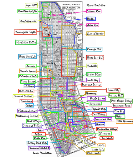
List of Manhattan neighborhoods
Encyclopedia
Manhattan
Manhattan is the oldest and the most densely populated of the five boroughs of New York City. Located primarily on the island of Manhattan at the mouth of the Hudson River, the boundaries of the borough are identical to those of New York County, an original county of the state of New York...
arranged geographically from the north of the island to the south.
Please note the following approximate definitions:
- Uptown Manhattan refers to the area above 59th Street59th Street (Manhattan)59th Street in the New York City borough of Manhattan runs east-west, from York Avenue to the West Side Highway, with a discontinuity between Ninth Avenue/Columbus Avenue and Eighth Avenue/Central Park West for the Time Warner Center. Although it is bi-directional for most of its length, the...
; Upper ManhattanUpper ManhattanUpper Manhattan denotes the more northerly region of the New York City Borough of Manhattan. Its southern boundary may be defined anywhere between 59th Street and 155th Street. Between these two extremes lies the most common definitions of Upper Manhattan as Manhattan above 96th Street...
refers to the area above 96th Street96th Street (Manhattan)96th Street is a major two-way street in East Harlem and the Upper West Side, which is a part of the New York City borough of Manhattan, running from the East River at the FDR Drive to the Henry Hudson Parkway at the Hudson River...
. - Downtown Manhattan refers to the area below 14th Street14th Street (Manhattan)14th Street is a major crosstown street in the New York City borough of Manhattan. The street rivals the size of some of the well-known avenues of the city and is an important business location....
; Lower ManhattanLower ManhattanLower Manhattan is the southernmost part of the island of Manhattan, the main island and center of business and government of the City of New York...
refers to the area below Chambers StreetChambers Street (Manhattan)Chambers Street is a bi-directional street in the New York City borough of Manhattan. It runs from River Terrace, Battery Park City, in the west, past PS 234 and Stuyvesant High School to 1 Centre Street, the Manhattan Municipal Building, to the east. In the early 20th century the street...
. - Midtown ManhattanMidtown ManhattanMidtown Manhattan, or simply Midtown, is an area of Manhattan, New York City home to world-famous commercial zones such as Rockefeller Center, Broadway, and Times Square...
refers to the area between 34th Street34th Street (Manhattan)34th Street is a major cross-town street in the New York City borough of Manhattan, connecting the Lincoln Tunnel and Queens-Midtown Tunnel. Like many of New York City's major crosstown streets, it has its own bus routes and four subway stops serving the trains at Eighth Avenue, the trains at...
and 59th Street59th Street (Manhattan)59th Street in the New York City borough of Manhattan runs east-west, from York Avenue to the West Side Highway, with a discontinuity between Ninth Avenue/Columbus Avenue and Eighth Avenue/Central Park West for the Time Warner Center. Although it is bi-directional for most of its length, the...
. - West Side refers to the area west of Fifth AvenueFifth Avenue (Manhattan)Fifth Avenue is a major thoroughfare in the center of the borough of Manhattan in New York City, New York, United States. The section of Fifth Avenue that crosses Midtown Manhattan, especially that between 49th Street and 60th Street, is lined with prestigious shops and is consistently ranked among...
; East Side refers to the area east of Fifth AvenueFifth Avenue (Manhattan)Fifth Avenue is a major thoroughfare in the center of the borough of Manhattan in New York City, New York, United States. The section of Fifth Avenue that crosses Midtown Manhattan, especially that between 49th Street and 60th Street, is lined with prestigious shops and is consistently ranked among...
.
Neighborhood names and boundaries are not officially defined. They may vary or change from time to time due to demographic and economic variables.
Uptown neighborhoods
| Name of the neighborhood | Limits South to North and East to West |
| Upper Manhattan Upper Manhattan Upper Manhattan denotes the more northerly region of the New York City Borough of Manhattan. Its southern boundary may be defined anywhere between 59th Street and 155th Street. Between these two extremes lies the most common definitions of Upper Manhattan as Manhattan above 96th Street... |
above 95th St |
| Marble Hill Marble Hill, Manhattan Marble Hill is the neighborhood which makes up the northernmost part of the Borough of Manhattan in New York City, United States. Although it is politically part of Manhattan and New York County, because of the re-routing of the Harlem River, it is located on the North American mainland contiguous... |
physically located on the mainland |
| Inwood Inwood, Manhattan Inwood is the northernmost neighborhood on Manhattan Island in the New York City borough of Manhattan.-Geography:Inwood is physically bounded by the Harlem River to the north and east, and the Hudson River to the west. It extends southward to Fort Tryon Park and alternatively Dyckman Street or... |
above Dyckman St |
| Fort George | Between Nagel Ave, Dyckman St and 192nd, includes Broadway South to Fairview Avenue |
| Washington Heights Washington Heights, Manhattan Washington Heights is a New York City neighborhood in the northern reaches of the borough of Manhattan. It is named for Fort Washington, a fortification constructed at the highest point on Manhattan island by Continental Army troops during the American Revolutionary War, to defend the area from the... |
W155 (once 125) to Dyckman St |
| Hudson Heights (Part of Washington Heights) | W173 to Fort Tryon Park Fort Tryon Park Fort Tryon Park is a public park located in the Washington Heights section of the borough of Manhattan in New York City, USA. It is situated on a 67 acre ridge in Upper Manhattan, with a commanding view of the Hudson River, the George Washington Bridge, the New Jersey Palisades and the Harlem River... ; B-way to the river Hudson River The Hudson is a river that flows from north to south through eastern New York. The highest official source is at Lake Tear of the Clouds, on the slopes of Mount Marcy in the Adirondack Mountains. The river itself officially begins in Henderson Lake in Newcomb, New York... |
| West Harlem Harlem Harlem is a neighborhood in the New York City borough of Manhattan, which since the 1920s has been a major African-American residential, cultural and business center. Originally a Dutch village, formally organized in 1658, it is named after the city of Haarlem in the Netherlands... |
W125-155; St. Nick Saint Nicholas Avenue (Manhattan) Saint Nicholas Avenue is a major New York City street. It runs north-south between 193rd Street and 111th Streets in the New York City borough of Manhattan. It goes through the neighborhoods of Washington Heights, Harlem, Hamilton Heights, and Inwood... to the river Hudson River The Hudson is a river that flows from north to south through eastern New York. The highest official source is at Lake Tear of the Clouds, on the slopes of Mount Marcy in the Adirondack Mountains. The river itself officially begins in Henderson Lake in Newcomb, New York... |
| Hamilton Heights (West Harlem) | W135-155; St. Nick Saint Nicholas Avenue (Manhattan) Saint Nicholas Avenue is a major New York City street. It runs north-south between 193rd Street and 111th Streets in the New York City borough of Manhattan. It goes through the neighborhoods of Washington Heights, Harlem, Hamilton Heights, and Inwood... to the river Hudson River The Hudson is a river that flows from north to south through eastern New York. The highest official source is at Lake Tear of the Clouds, on the slopes of Mount Marcy in the Adirondack Mountains. The river itself officially begins in Henderson Lake in Newcomb, New York... |
| Manhattanville Manhattanville Manhattanville is a neighborhood in the New York City borough of Manhattan bordered on the south by Morningside Heights on the west by the Hudson River, on the east by Harlem and on the north by Hamilton Heights. Its borders straddle West 125th Street, roughly from 122nd Street to 135th Street and... (West Harlem) |
W125-135; St. Nick Saint Nicholas Avenue (Manhattan) Saint Nicholas Avenue is a major New York City street. It runs north-south between 193rd Street and 111th Streets in the New York City borough of Manhattan. It goes through the neighborhoods of Washington Heights, Harlem, Hamilton Heights, and Inwood... to the river Hudson River The Hudson is a river that flows from north to south through eastern New York. The highest official source is at Lake Tear of the Clouds, on the slopes of Mount Marcy in the Adirondack Mountains. The river itself officially begins in Henderson Lake in Newcomb, New York... |
| ViVa Manhattanville Manhattanville is a neighborhood in the New York City borough of Manhattan bordered on the south by Morningside Heights on the west by the Hudson River, on the east by Harlem and on the north by Hamilton Heights. Its borders straddle West 125th Street, roughly from 122nd Street to 135th Street and... , Viaduct Valley |
W125-132; the river Hudson River The Hudson is a river that flows from north to south through eastern New York. The highest official source is at Lake Tear of the Clouds, on the slopes of Mount Marcy in the Adirondack Mountains. The river itself officially begins in Henderson Lake in Newcomb, New York... |
| Morningside Heights, SoHa (or "South of Harlem") | W96-125; Columbus Ninth Avenue (Manhattan) Ninth Avenue / Columbus Avenue is a southbound thoroughfare on the West Side of Manhattan in New York City. Traffic runs downtown along its full length... to Riverside Riverside Drive (Manhattan) Riverside Drive is a scenic north-south thoroughfare in the Manhattan borough of New York City. The boulevard runs on the west side of Manhattan, generally parallel to the Hudson River from 72nd Street to near the George Washington Bridge at 181st Street... |
| Central Harlem Harlem Harlem is a neighborhood in the New York City borough of Manhattan, which since the 1920s has been a major African-American residential, cultural and business center. Originally a Dutch village, formally organized in 1658, it is named after the city of Haarlem in the Netherlands... |
E110-155; Park Park Avenue (Manhattan) Park Avenue is a wide boulevard that carries north and southbound traffic in New York City borough of Manhattan. Through most of its length, it runs parallel to Madison Avenue to the west and Lexington Avenue to the east.... to St. Nick Saint Nicholas Avenue (Manhattan) Saint Nicholas Avenue is a major New York City street. It runs north-south between 193rd Street and 111th Streets in the New York City borough of Manhattan. It goes through the neighborhoods of Washington Heights, Harlem, Hamilton Heights, and Inwood... |
| Harlem Harlem Harlem is a neighborhood in the New York City borough of Manhattan, which since the 1920s has been a major African-American residential, cultural and business center. Originally a Dutch village, formally organized in 1658, it is named after the city of Haarlem in the Netherlands... |
E96-141 (east), W110-155 (central), W125-155 (west) |
| Strivers' Row Strivers' Row Strivers' Row is three rows of townhouses in western Harlem, in the New York City borough of Manhattan on West 138th and West 139th between Adam Clayton Powell Jr. Boulevard and Frederick Douglass Boulevard. Originally called the "King Model Houses" after developer David King, they were designed... (Central Harlem) |
W137-138; 7th-8th Eighth Avenue (Manhattan) Eighth Avenue is a north-south avenue on the West Side of Manhattan in New York City, carrying northbound traffic. Eighth Avenue begins in the West Village neighborhood at Abingdon Square and runs north for 44 blocks through Chelsea, the Garment District, Hell's Kitchen's east end, Midtown and the... |
| Astor Row Astor Row Astor Row is the name given to 130th Street between Fifth Avenue and Lenox Avenue in Harlem, in the New York City borough of Manhattan. More specifically, it refers to the semi-attached row houses on the south side of the street. These were among the first speculative townhouses built in Harlem,... (Central Harlem) |
centered at W130 |
| Sugar Hill Sugar Hill, Manhattan Sugar Hill is a neighborhood in the northern part of Hamilton Heights, which itself is a sub-neighborhood of Harlem, a neighborhood in the New York City borough of Manhattan. The neighborhood is defined by 155th Street to the north, 145th Street to the south, Edgecombe Avenue to the east, and... (Central Harlem) |
W125-155; Edgecombe Avenue to Amsterdam Tenth Avenue (Manhattan) Tenth Avenue, known as Amsterdam Avenue north of 59th Street, is a north-south thoroughfare on the West Side of Manhattan in New York City. It carries uptown traffic as far as West 110th Street, also known as Cathedral Parkway for the Cathedral Church of St. John the Divine... |
| Marcus Garvey Park Marcus Garvey Park Marcus Garvey Park, or Mount Morris Park as it is referred to by the people in the neighborhood, is located in Harlem in the New York City borough of Manhattan. The park interrupts the flow of Fifth Avenue, which is routed around the park via Mount Morris Park West. The park is bounded by 120th... , Mount Morris Historical District |
E120-124; Madison Madison Avenue (Manhattan) Madison Avenue is a north-south avenue in the borough of Manhattan in New York City, United States, that carries northbound one-way traffic. It runs from Madison Square to the Madison Avenue Bridge at 138th Street. In doing so, it passes through Midtown, the Upper East Side , Spanish Harlem, and... to 5th Fifth Avenue (Manhattan) Fifth Avenue is a major thoroughfare in the center of the borough of Manhattan in New York City, New York, United States. The section of Fifth Avenue that crosses Midtown Manhattan, especially that between 49th Street and 60th Street, is lined with prestigious shops and is consistently ranked among... |
| Le Petit Senegal Le Petit Senegal Le Petit Sénégal, or Little Senegal, is a neighborhood in the New York City borough of Manhattan. It has been called Le Petit Senegal by the West African immigrant community and Little Senegal by some people from outside the neighborhood.... (Little Senegal) |
W. 116 116th Street (Manhattan) 116th Street runs from Riverside Drive, overlooking the Hudson River, to the East River, through the New York City borough of Manhattan. It traverses the neighborhoods of Morningside Heights, Harlem, and Spanish Harlem; the street is interrupted between Morningside Heights and Harlem by Morningside... ; East of Morningside Park, rapidly growing neighborhood |
| East Harlem (Spanish Harlem) | E96-141; the river East River The East River is a tidal strait in New York City. It connects Upper New York Bay on its south end to Long Island Sound on its north end. It separates Long Island from the island of Manhattan and the Bronx on the North American mainland... to 5th Fifth Avenue (Manhattan) Fifth Avenue is a major thoroughfare in the center of the borough of Manhattan in New York City, New York, United States. The section of Fifth Avenue that crosses Midtown Manhattan, especially that between 49th Street and 60th Street, is lined with prestigious shops and is consistently ranked among... |
| Upper East Side Upper East Side The Upper East Side is a neighborhood in the borough of Manhattan in New York City, between Central Park and the East River. The Upper East Side lies within an area bounded by 59th Street to 96th Street, and the East River to Fifth Avenue-Central Park... , Lenox Hill Lenox Hill Lenox Hill is a neighborhood on Manhattan's Upper East Side. It forms the lower section of the Upper East Side, closest to Midtown. While it is agreed that the neighborhood ranges from 72nd Street to 59th Street, its eastern border is disputed, though The Encyclopedia of New York City cites Fifth... , Silk Stocking District |
E59-96; the river East River The East River is a tidal strait in New York City. It connects Upper New York Bay on its south end to Long Island Sound on its north end. It separates Long Island from the island of Manhattan and the Bronx on the North American mainland... to 5th Fifth Avenue (Manhattan) Fifth Avenue is a major thoroughfare in the center of the borough of Manhattan in New York City, New York, United States. The section of Fifth Avenue that crosses Midtown Manhattan, especially that between 49th Street and 60th Street, is lined with prestigious shops and is consistently ranked among... (and E96-110 along 5th Fifth Avenue (Manhattan) Fifth Avenue is a major thoroughfare in the center of the borough of Manhattan in New York City, New York, United States. The section of Fifth Avenue that crosses Midtown Manhattan, especially that between 49th Street and 60th Street, is lined with prestigious shops and is consistently ranked among... ) |
| Carnegie Hill | E86-98; 3rd Third Avenue (Manhattan) Third Avenue is a north-south thoroughfare on the East Side of the New York City borough of Manhattan, running from Cooper Square north for over 120 blocks. Third Avenue continues into The Bronx across the Harlem River over the Third Avenue Bridge north of East 129th Street to East Fordham Road at... to 5th Fifth Avenue (Manhattan) Fifth Avenue is a major thoroughfare in the center of the borough of Manhattan in New York City, New York, United States. The section of Fifth Avenue that crosses Midtown Manhattan, especially that between 49th Street and 60th Street, is lined with prestigious shops and is consistently ranked among... (centered at E91 and Park Park Avenue (Manhattan) Park Avenue is a wide boulevard that carries north and southbound traffic in New York City borough of Manhattan. Through most of its length, it runs parallel to Madison Avenue to the west and Lexington Avenue to the east.... ) |
| Yorkville Yorkville, Manhattan Yorkville is a neighborhood in the greater Upper East Side, in the Borough of Manhattan in New York City. Yorkville's boundaries include: the East River on the east, 96th Street on the north, Third Avenue on the west and 72nd Street to the south. However, its southern boundary is a subject of... |
E79-96; the river East River The East River is a tidal strait in New York City. It connects Upper New York Bay on its south end to Long Island Sound on its north end. It separates Long Island from the island of Manhattan and the Bronx on the North American mainland... to 3rd Third Avenue (Manhattan) Third Avenue is a north-south thoroughfare on the East Side of the New York City borough of Manhattan, running from Cooper Square north for over 120 blocks. Third Avenue continues into The Bronx across the Harlem River over the Third Avenue Bridge north of East 129th Street to East Fordham Road at... (centered at E86 and 3rd Third Avenue (Manhattan) Third Avenue is a north-south thoroughfare on the East Side of the New York City borough of Manhattan, running from Cooper Square north for over 120 blocks. Third Avenue continues into The Bronx across the Harlem River over the Third Avenue Bridge north of East 129th Street to East Fordham Road at... ) |
| Upper West Side Upper West Side The Upper West Side is a neighborhood in the borough of Manhattan, New York City, that lies between Central Park and the Hudson River and between West 59th Street and West 125th Street... |
W59-110; Central Park W Eighth Avenue (Manhattan) Eighth Avenue is a north-south avenue on the West Side of Manhattan in New York City, carrying northbound traffic. Eighth Avenue begins in the West Village neighborhood at Abingdon Square and runs north for 44 blocks through Chelsea, the Garment District, Hell's Kitchen's east end, Midtown and the... to the river Hudson River The Hudson is a river that flows from north to south through eastern New York. The highest official source is at Lake Tear of the Clouds, on the slopes of Mount Marcy in the Adirondack Mountains. The river itself officially begins in Henderson Lake in Newcomb, New York... |
| Manhattan Valley Manhattan Valley Manhattan Valley is a neighborhood on the Upper West Side of Manhattan in New York City, bounded by West 110th Street to the north, Central Park West to the east, West 96th Street to the south, and Broadway to the west... , Bloomingdale District |
W96-110; Central Park W Eighth Avenue (Manhattan) Eighth Avenue is a north-south avenue on the West Side of Manhattan in New York City, carrying northbound traffic. Eighth Avenue begins in the West Village neighborhood at Abingdon Square and runs north for 44 blocks through Chelsea, the Garment District, Hell's Kitchen's east end, Midtown and the... to B-way |
| Lincoln Square Lincoln Square, New York Lincoln Square is the name of both a square and the surrounding neighborhood within the Upper West Side of the New York City borough of Manhattan... (once San Juan Hill San Juan Hill, Manhattan San Juan Hill was a predominantly African American neighborhood of tenements on the West Side of the borough of Manhattan in New York City, which was largely razed as part of urban renewal to make way for Lincoln Center for the Performing Arts.... ) |
W65-66; Columbus Ninth Avenue (Manhattan) Ninth Avenue / Columbus Avenue is a southbound thoroughfare on the West Side of Manhattan in New York City. Traffic runs downtown along its full length... to B-way |
Midtown neighborhoods
| Name of the neighborhood | Limits South to North and East to West |
| Midtown Midtown Manhattan Midtown Manhattan, or simply Midtown, is an area of Manhattan, New York City home to world-famous commercial zones such as Rockefeller Center, Broadway, and Times Square... |
34th to 59th St |
| Columbus Circle Columbus Circle Columbus Circle, named for Christopher Columbus, is a major landmark and point of attraction in the New York City borough of Manhattan, located at the intersection of Eighth Avenue, Broadway, Central Park South , and Central Park West, at the southwest corner of Central Park. It is the point from... |
W59 and 8th Eighth Avenue (Manhattan) Eighth Avenue is a north-south avenue on the West Side of Manhattan in New York City, carrying northbound traffic. Eighth Avenue begins in the West Village neighborhood at Abingdon Square and runs north for 44 blocks through Chelsea, the Garment District, Hell's Kitchen's east end, Midtown and the... |
| Sutton Place Sutton Place, Manhattan Sutton Place is the name given to one of the most affluent streets in the borough of Manhattan in New York City, New York, United States, situated on the border between the Midtown and Upper East Side neighborhoods... |
E53-59 and Sutton Pl |
| Rockefeller Center Rockefeller Center Rockefeller Center is a complex of 19 commercial buildings covering between 48th and 51st streets in New York City, United States. Built by the Rockefeller family, it is located in the center of Midtown Manhattan, spanning the area between Fifth Avenue and Sixth Avenue. It was declared a National... , Radio City |
W49-51 and 5th Fifth Avenue (Manhattan) Fifth Avenue is a major thoroughfare in the center of the borough of Manhattan in New York City, New York, United States. The section of Fifth Avenue that crosses Midtown Manhattan, especially that between 49th Street and 60th Street, is lined with prestigious shops and is consistently ranked among... to 6th Sixth Avenue (Manhattan) Sixth Avenue – officially Avenue of the Americas, although this name is seldom used by New Yorkers – is a major thoroughfare in New York City's borough of Manhattan, on which traffic runs northbound, or "uptown"... |
| Diamond District Diamond District, Manhattan The Diamond District is an area of New York City located on West 47th Street between Fifth Avenue and Sixth Avenue in midtown Manhattan, within walking distance of many New York attractions... |
W47 and 5th Fifth Avenue (Manhattan) Fifth Avenue is a major thoroughfare in the center of the borough of Manhattan in New York City, New York, United States. The section of Fifth Avenue that crosses Midtown Manhattan, especially that between 49th Street and 60th Street, is lined with prestigious shops and is consistently ranked among... to 6th Sixth Avenue (Manhattan) Sixth Avenue – officially Avenue of the Americas, although this name is seldom used by New Yorkers – is a major thoroughfare in New York City's borough of Manhattan, on which traffic runs northbound, or "uptown"... |
| Theater District | W42-53 and 6th Sixth Avenue (Manhattan) Sixth Avenue – officially Avenue of the Americas, although this name is seldom used by New Yorkers – is a major thoroughfare in New York City's borough of Manhattan, on which traffic runs northbound, or "uptown"... to 8th Eighth Avenue (Manhattan) Eighth Avenue is a north-south avenue on the West Side of Manhattan in New York City, carrying northbound traffic. Eighth Avenue begins in the West Village neighborhood at Abingdon Square and runs north for 44 blocks through Chelsea, the Garment District, Hell's Kitchen's east end, Midtown and the... |
| Turtle Bay Turtle Bay, Manhattan Turtle Bay is a neighborhood in New York City, on the east side of Midtown Manhattan. It extends between 41st and 54th Streets, and eastward from Lexington Avenue to the East River, across from Roosevelt Island... |
E42-53 and the river East River The East River is a tidal strait in New York City. It connects Upper New York Bay on its south end to Long Island Sound on its north end. It separates Long Island from the island of Manhattan and the Bronx on the North American mainland... to Lex Lexington Avenue (Manhattan) Lexington Avenue, often colloquially abbreviated by New Yorkers as "Lex," is an avenue on the East Side of the borough of Manhattan in New York City that carries southbound one-way traffic from East 131st Street to Gramercy Park at East 21st Street... |
| Midtown East | 42-59 and the river East River The East River is a tidal strait in New York City. It connects Upper New York Bay on its south end to Long Island Sound on its north end. It separates Long Island from the island of Manhattan and the Bronx on the North American mainland... to 5th Fifth Avenue (Manhattan) Fifth Avenue is a major thoroughfare in the center of the borough of Manhattan in New York City, New York, United States. The section of Fifth Avenue that crosses Midtown Manhattan, especially that between 49th Street and 60th Street, is lined with prestigious shops and is consistently ranked among... |
| Midtown | 40-59 and 3rd Third Avenue (Manhattan) Third Avenue is a north-south thoroughfare on the East Side of the New York City borough of Manhattan, running from Cooper Square north for over 120 blocks. Third Avenue continues into The Bronx across the Harlem River over the Third Avenue Bridge north of East 129th Street to East Fordham Road at... to 9th Ninth Avenue (Manhattan) Ninth Avenue / Columbus Avenue is a southbound thoroughfare on the West Side of Manhattan in New York City. Traffic runs downtown along its full length... |
| Tudor City Tudor City Tudor City is an apartment complex located on the East Side of Manhattan in New York City. It is the first residential skyscraper complex in the world. It is bordered by East 40th Street to the south, First Avenue to the east, Second Avenue to the west, and East 43rd Street to the north... |
E40-43 and 1st First Avenue (Manhattan) First Avenue is a north-south thoroughfare on the East Side of the New York City borough of Manhattan, running from Houston Street northbound for over 125 blocks before terminating at the Willis Avenue Bridge into The Bronx at the Harlem River near East 127th Street. South of Houston Street, the... to 2nd Second Avenue (Manhattan) Second Avenue is an avenue on the East Side of the New York City borough of Manhattan extending from Houston Street at its south end to the Harlem River Drive at 128th Street at its north end. A one-way street, vehicular traffic runs only downtown. A bicycle lane in the left hand portion from 55th... |
| Little Brazil | W46 and 5th Fifth Avenue (Manhattan) Fifth Avenue is a major thoroughfare in the center of the borough of Manhattan in New York City, New York, United States. The section of Fifth Avenue that crosses Midtown Manhattan, especially that between 49th Street and 60th Street, is lined with prestigious shops and is consistently ranked among... to 6th Sixth Avenue (Manhattan) Sixth Avenue – officially Avenue of the Americas, although this name is seldom used by New Yorkers – is a major thoroughfare in New York City's borough of Manhattan, on which traffic runs northbound, or "uptown"... |
| Times Square Times Square Times Square is a major commercial intersection in the borough of Manhattan in New York City, at the junction of Broadway and Seventh Avenue and stretching from West 42nd to West 47th Streets... |
W39-52 and 7th Seventh Avenue (Manhattan) Seventh Avenue, known as Adam Clayton Powell Jr. Boulevard north of Central Park, is a thoroughfare on the West Side of the borough of Manhattan in New York City. It is southbound below Central Park and a two-way street north of the park.... -9th Ninth Avenue (Manhattan) Ninth Avenue / Columbus Avenue is a southbound thoroughfare on the West Side of Manhattan in New York City. Traffic runs downtown along its full length... |
| Hudson Yards | W28-43 and 7th Seventh Avenue (Manhattan) Seventh Avenue, known as Adam Clayton Powell Jr. Boulevard north of Central Park, is a thoroughfare on the West Side of the borough of Manhattan in New York City. It is southbound below Central Park and a two-way street north of the park.... to the river Hudson River The Hudson is a river that flows from north to south through eastern New York. The highest official source is at Lake Tear of the Clouds, on the slopes of Mount Marcy in the Adirondack Mountains. The river itself officially begins in Henderson Lake in Newcomb, New York... |
| Midtown West | W34-59 and 5th Fifth Avenue (Manhattan) Fifth Avenue is a major thoroughfare in the center of the borough of Manhattan in New York City, New York, United States. The section of Fifth Avenue that crosses Midtown Manhattan, especially that between 49th Street and 60th Street, is lined with prestigious shops and is consistently ranked among... to the river Hudson River The Hudson is a river that flows from north to south through eastern New York. The highest official source is at Lake Tear of the Clouds, on the slopes of Mount Marcy in the Adirondack Mountains. The river itself officially begins in Henderson Lake in Newcomb, New York... |
| Hell's Kitchen Hell's Kitchen, Manhattan Hell's Kitchen, also known as Clinton and Midtown West, is a neighborhood of Manhattan in New York City between 34th Street and 59th Street, from 8th Avenue to the Hudson River.... , Clinton |
W34-57 (59) and 8th Eighth Avenue (Manhattan) Eighth Avenue is a north-south avenue on the West Side of Manhattan in New York City, carrying northbound traffic. Eighth Avenue begins in the West Village neighborhood at Abingdon Square and runs north for 44 blocks through Chelsea, the Garment District, Hell's Kitchen's east end, Midtown and the... to the river Hudson River The Hudson is a river that flows from north to south through eastern New York. The highest official source is at Lake Tear of the Clouds, on the slopes of Mount Marcy in the Adirondack Mountains. The river itself officially begins in Henderson Lake in Newcomb, New York... |
| Garment District Garment District, Manhattan The Garment District, also known as the Garment Center, the Fashion District, or the Fashion Center, is a neighborhood located in the Manhattan borough of New York City. The dense concentration of fashion-related uses give the neighborhood, which is generally considered to span between Fifth Avenue... |
W34-42 and 5th Fifth Avenue (Manhattan) Fifth Avenue is a major thoroughfare in the center of the borough of Manhattan in New York City, New York, United States. The section of Fifth Avenue that crosses Midtown Manhattan, especially that between 49th Street and 60th Street, is lined with prestigious shops and is consistently ranked among... to 9th Ninth Avenue (Manhattan) Ninth Avenue / Columbus Avenue is a southbound thoroughfare on the West Side of Manhattan in New York City. Traffic runs downtown along its full length... |
| Herald Square Herald Square Herald Square is formed by the intersection of Broadway, Sixth Avenue and 34th Street in the borough of Manhattan in New York City. Named for the New York Herald, a now-defunct newspaper formerly headquartered there, it also gives its name to the surrounding area... |
W34 and 6th Sixth Avenue (Manhattan) Sixth Avenue – officially Avenue of the Americas, although this name is seldom used by New Yorkers – is a major thoroughfare in New York City's borough of Manhattan, on which traffic runs northbound, or "uptown"... |
| Koreatown Koreatown, Manhattan Koreatown, or K-town as it is colloquially known, is a neighborhood in the New York City borough of Manhattan, that is generally bordered by 31st and 36th Streets and Fifth Avenue and Sixth Avenues... |
W31-36 and 5th Fifth Avenue (Manhattan) Fifth Avenue is a major thoroughfare in the center of the borough of Manhattan in New York City, New York, United States. The section of Fifth Avenue that crosses Midtown Manhattan, especially that between 49th Street and 60th Street, is lined with prestigious shops and is consistently ranked among... to 6th Sixth Avenue (Manhattan) Sixth Avenue – officially Avenue of the Americas, although this name is seldom used by New Yorkers – is a major thoroughfare in New York City's borough of Manhattan, on which traffic runs northbound, or "uptown"... |
| Murray Hill Murray Hill, Manhattan Murray Hill is a Midtown Manhattan neighborhood in New York City, USA. Around 1987 many real estate promoters of the neighborhood and newer residents described the boundaries as within East 34th Street, East 42nd Street, Madison Avenue, and the East River; in 1999, Frank P... |
E29-42 and 2nd Second Avenue (Manhattan) Second Avenue is an avenue on the East Side of the New York City borough of Manhattan extending from Houston Street at its south end to the Harlem River Drive at 128th Street at its north end. A one-way street, vehicular traffic runs only downtown. A bicycle lane in the left hand portion from 55th... to 5th Fifth Avenue (Manhattan) Fifth Avenue is a major thoroughfare in the center of the borough of Manhattan in New York City, New York, United States. The section of Fifth Avenue that crosses Midtown Manhattan, especially that between 49th Street and 60th Street, is lined with prestigious shops and is consistently ranked among... |
| Tenderloin Tenderloin, Manhattan The Tenderloin was an entertainment and red-light district in the heart of the New York City borough of Manhattan during the late 19th and early 20th centuries... |
W23-42 and 5th Fifth Avenue (Manhattan) Fifth Avenue is a major thoroughfare in the center of the borough of Manhattan in New York City, New York, United States. The section of Fifth Avenue that crosses Midtown Manhattan, especially that between 49th Street and 60th Street, is lined with prestigious shops and is consistently ranked among... to 7th Seventh Avenue (Manhattan) Seventh Avenue, known as Adam Clayton Powell Jr. Boulevard north of Central Park, is a thoroughfare on the West Side of the borough of Manhattan in New York City. It is southbound below Central Park and a two-way street north of the park.... |
| Madison Square Madison Square Madison Square is formed by the intersection of Fifth Avenue and Broadway at 23rd Street in the New York City borough of Manhattan. The square was named for James Madison, fourth President of the United States and the principal author of the United States Constitution.The focus of the square is... |
W23-26 and 5th Fifth Avenue (Manhattan) Fifth Avenue is a major thoroughfare in the center of the borough of Manhattan in New York City, New York, United States. The section of Fifth Avenue that crosses Midtown Manhattan, especially that between 49th Street and 60th Street, is lined with prestigious shops and is consistently ranked among... to B-way |
Neighborhoods between midtown and downtown
| Name of the neighborhood | Limits South to North and East to West |
| Flower District | W26-28 and 6th Sixth Avenue (Manhattan) Sixth Avenue – officially Avenue of the Americas, although this name is seldom used by New Yorkers – is a major thoroughfare in New York City's borough of Manhattan, on which traffic runs northbound, or "uptown"... |
| Brookdale | E25th and 1st First Avenue (Manhattan) First Avenue is a north-south thoroughfare on the East Side of the New York City borough of Manhattan, running from Houston Street northbound for over 125 blocks before terminating at the Willis Avenue Bridge into The Bronx at the Harlem River near East 127th Street. South of Houston Street, the... to FDR Franklin D. Roosevelt East River Drive The Franklin D. Roosevelt East River Drive is a freeway-standard parkway on the east side of the New York City borough of Manhattan... |
| Kips Bay Kips Bay Kips Bay is a neighborhood in the New York City borough of Manhattan. Because there are no official boundaries for New York City neighborhoods, the limits of Kip's Bay are somewhat vague, but it is often considered to be the area between East 23rd Street and East 34th Street extending from... |
E23 23rd Street (Manhattan) 23rd Street is a broad thoroughfare in the New York City borough of Manhattan. It is one of few two-way streets in the gridiron of the borough. As with Manhattan's other "crosstown" streets, it is divided at Fifth Avenue, in this case at Madison Square Park, into its east and west sections. Since... -34 34th Street (Manhattan) 34th Street is a major cross-town street in the New York City borough of Manhattan, connecting the Lincoln Tunnel and Queens-Midtown Tunnel. Like many of New York City's major crosstown streets, it has its own bus routes and four subway stops serving the trains at Eighth Avenue, the trains at... and the river East River The East River is a tidal strait in New York City. It connects Upper New York Bay on its south end to Long Island Sound on its north end. It separates Long Island from the island of Manhattan and the Bronx on the North American mainland... to 3rd Third Avenue (Manhattan) Third Avenue is a north-south thoroughfare on the East Side of the New York City borough of Manhattan, running from Cooper Square north for over 120 blocks. Third Avenue continues into The Bronx across the Harlem River over the Third Avenue Bridge north of East 129th Street to East Fordham Road at... |
| Rose Hill | E25-30 and 3rd Third Avenue (Manhattan) Third Avenue is a north-south thoroughfare on the East Side of the New York City borough of Manhattan, running from Cooper Square north for over 120 blocks. Third Avenue continues into The Bronx across the Harlem River over the Third Avenue Bridge north of East 129th Street to East Fordham Road at... to Madison |
| NoMad NoMad NoMad is a neighborhood centered around the Madison Square North Historic District in the borough of Manhattan in New York City.... |
W25-30 and Lex to 6th |
| Peter Cooper Village† (former Gas House district) | E20-23 23rd Street (Manhattan) 23rd Street is a broad thoroughfare in the New York City borough of Manhattan. It is one of few two-way streets in the gridiron of the borough. As with Manhattan's other "crosstown" streets, it is divided at Fifth Avenue, in this case at Madison Square Park, into its east and west sections. Since... and C to 1st First Avenue (Manhattan) First Avenue is a north-south thoroughfare on the East Side of the New York City borough of Manhattan, running from Houston Street northbound for over 125 blocks before terminating at the Willis Avenue Bridge into The Bronx at the Harlem River near East 127th Street. South of Houston Street, the... |
| Chelsea Chelsea, Manhattan Chelsea is a neighborhood on the West Side of the borough of Manhattan in New York City. The district's boundaries are roughly 14th Street to the south, 30th Street to the north, the western boundary of the Ladies' Mile Historic District – which lies between the Avenue of the Americas and... |
W14 14th Street (Manhattan) 14th Street is a major crosstown street in the New York City borough of Manhattan. The street rivals the size of some of the well-known avenues of the city and is an important business location.... -34 34th Street (Manhattan) 34th Street is a major cross-town street in the New York City borough of Manhattan, connecting the Lincoln Tunnel and Queens-Midtown Tunnel. Like many of New York City's major crosstown streets, it has its own bus routes and four subway stops serving the trains at Eighth Avenue, the trains at... and 7th Seventh Avenue (Manhattan) Seventh Avenue, known as Adam Clayton Powell Jr. Boulevard north of Central Park, is a thoroughfare on the West Side of the borough of Manhattan in New York City. It is southbound below Central Park and a two-way street north of the park.... to the river Hudson River The Hudson is a river that flows from north to south through eastern New York. The highest official source is at Lake Tear of the Clouds, on the slopes of Mount Marcy in the Adirondack Mountains. The river itself officially begins in Henderson Lake in Newcomb, New York... |
| Flatiron District Flatiron District, Manhattan The Flatiron District is a neighborhood in the New York City borough of Manhattan, named after the Flatiron Building at 23rd Street, Broadway and Fifth Avenue... , Toy District, Photo District |
E&W16-27 and Park Avenue South Park Avenue (Manhattan) Park Avenue is a wide boulevard that carries north and southbound traffic in New York City borough of Manhattan. Through most of its length, it runs parallel to Madison Avenue to the west and Lexington Avenue to the east.... to 6th Sixth Avenue (Manhattan) Sixth Avenue – officially Avenue of the Americas, although this name is seldom used by New Yorkers – is a major thoroughfare in New York City's borough of Manhattan, on which traffic runs northbound, or "uptown"... |
| Gramercy Park Gramercy Park Gramercy Park is a small, fenced-in private park in the borough of Manhattan in New York City, United States. The park is at the core of both the neighborhood referred to as either Gramercy or Gramercy Park and the Gramercy Park Historic District... |
E14 14th Street (Manhattan) 14th Street is a major crosstown street in the New York City borough of Manhattan. The street rivals the size of some of the well-known avenues of the city and is an important business location.... -23 23rd Street (Manhattan) 23rd Street is a broad thoroughfare in the New York City borough of Manhattan. It is one of few two-way streets in the gridiron of the borough. As with Manhattan's other "crosstown" streets, it is divided at Fifth Avenue, in this case at Madison Square Park, into its east and west sections. Since... and 1st First Avenue (Manhattan) First Avenue is a north-south thoroughfare on the East Side of the New York City borough of Manhattan, running from Houston Street northbound for over 125 blocks before terminating at the Willis Avenue Bridge into The Bronx at the Harlem River near East 127th Street. South of Houston Street, the... to Park Avenue So. Park Avenue (Manhattan) Park Avenue is a wide boulevard that carries north and southbound traffic in New York City borough of Manhattan. Through most of its length, it runs parallel to Madison Avenue to the west and Lexington Avenue to the east.... |
| Stuyvesant Square Stuyvesant Square __notoc__Stuyvesant Square is a park in the New York City borough of Manhattan, located between 15th Street and 17th Street and Rutherford Place and Nathan D. Perlman Place, formerly Livingston Place. Second Avenue divides the park into two halves, east and west, and each half is surrounded by the... |
E15-E18 and 1st First Avenue (Manhattan) First Avenue is a north-south thoroughfare on the East Side of the New York City borough of Manhattan, running from Houston Street northbound for over 125 blocks before terminating at the Willis Avenue Bridge into The Bronx at the Harlem River near East 127th Street. South of Houston Street, the... to 3rd Third Avenue (Manhattan) Third Avenue is a north-south thoroughfare on the East Side of the New York City borough of Manhattan, running from Cooper Square north for over 120 blocks. Third Avenue continues into The Bronx across the Harlem River over the Third Avenue Bridge north of East 129th Street to East Fordham Road at... |
| Union Square Union Square (New York City) Union Square is a public square in the Manhattan borough of New York City, New York.It is an important and historic intersection, located where Broadway and the former Bowery Road – now Fourth Avenue – came together in the early 19th century; its name celebrates neither the... |
E14 14th Street (Manhattan) 14th Street is a major crosstown street in the New York City borough of Manhattan. The street rivals the size of some of the well-known avenues of the city and is an important business location.... -17 17th Street (Manhattan) 17th Street is an east-west running street between First Avenue and Eleventh Avenue in the borough of Manhattan in New York City. Traffic runs one way along the street, from east to west excepting the stretch between Broadway and Park Avenue South, where traffic runs in both directions.17th Street... and 4th Park Avenue (Manhattan) Park Avenue is a wide boulevard that carries north and southbound traffic in New York City borough of Manhattan. Through most of its length, it runs parallel to Madison Avenue to the west and Lexington Avenue to the east.... to University Pl |
| Stuyvesant Town Stuyvesant Town Stuyvesant Town—Peter Cooper Village is a large private residential development on the East Side of the borough of Manhattan in New York City, and one of the most iconic and successful post-World War II private housing communities... † (former Gas House district) |
E14 14th Street (Manhattan) 14th Street is a major crosstown street in the New York City borough of Manhattan. The street rivals the size of some of the well-known avenues of the city and is an important business location.... -20 and C to 1st First Avenue (Manhattan) First Avenue is a north-south thoroughfare on the East Side of the New York City borough of Manhattan, running from Houston Street northbound for over 125 blocks before terminating at the Willis Avenue Bridge into The Bronx at the Harlem River near East 127th Street. South of Houston Street, the... |
| Meatpacking District Meatpacking District, Manhattan The Meatpacking District is a neighborhood in the New York City borough of Manhattan which runs roughly from West 14th Street south to Gansevoort Street, and from the Hudson River east to Hudson Street, although recently it is sometimes considered to have extended north to West 16th Street and east... |
Gansevoort to W15th and Hudson Hudson Street (Manhattan) Hudson Street is a north/south oriented street in the New York City borough of Manhattan. Running from TriBeCa to Greenwich Village and through Hudson Square, Hudson Street has two distinct one-way traffic patterns that meet at Abingdon Square, at the street's intersection with Eighth Avenue and... to the river Hudson River The Hudson is a river that flows from north to south through eastern New York. The highest official source is at Lake Tear of the Clouds, on the slopes of Mount Marcy in the Adirondack Mountains. The river itself officially begins in Henderson Lake in Newcomb, New York... |
| Waterside Plaza Waterside Plaza Waterside Plaza, formerly a Mitchell-Lama Housing Program-funded rental apartment complex, is located on the East River in the Kips Bay section of Manhattan, New York City.- Overview :... |
E25-29th and FDR Drive |
†Large scale developments
Downtown neighborhoods
| Name of the neighborhood | Limits South to North and East to West |
| Downtown Manhattan Lower Manhattan Lower Manhattan is the southernmost part of the island of Manhattan, the main island and center of business and government of the City of New York... |
below 14th Street 14th Street (Manhattan) 14th Street is a major crosstown street in the New York City borough of Manhattan. The street rivals the size of some of the well-known avenues of the city and is an important business location.... |
| Little Germany Little Germany, New York Little Germany, known in German as Kleindeutschland and Deutschländle and called Dutchtown by contemporary non-Germans, was a German immigrant neighborhood on the Lower East Side of Manhattan in New York City... (historic) |
E7-10 and A Avenue A (Manhattan) Avenue A runs from north to south and is the westernmost of the avenues to be defined by letters instead of using the numbering system in the New York City borough of Manhattan. Avenue A runs from Houston Street to 14th Street, where it continues into a loop road in Stuyvesant Town, connecting to... to B Avenue B (Manhattan) Avenue B runs from south to north and is two blocks east of 1st Avenue in Alphabet City, a district within the East Village. Avenue B runs from Houston Street to 14th Street, where it continues into a loop road in Stuyvesant Town, to be connected with Avenue A. Below Houston Street, Avenue B... |
| Alphabet City Alphabet City, Manhattan Alphabet City is a neighborhood located within the Lower East Side and East Village in the New York City borough of Manhattan. It is also known as Loisaida, a Spanglish adaptation of 'Lower East Side'. Its name comes from Avenues A, B, C, and D, the only avenues in Manhattan to have single-letter... , Loisaida Loisaida Loisaida is a term derived from the Latino pronunciation of "Lower East Side", a neighborhood in Manhattan, New York City. The term was originally coined by poet/activist Bittman "Bimbo" Rivas in his 1974 poem "Loisaida"... |
Houston to E23rd 23rd Street (Manhattan) 23rd Street is a broad thoroughfare in the New York City borough of Manhattan. It is one of few two-way streets in the gridiron of the borough. As with Manhattan's other "crosstown" streets, it is divided at Fifth Avenue, in this case at Madison Square Park, into its east and west sections. Since... (14th 14th Street (Manhattan) 14th Street is a major crosstown street in the New York City borough of Manhattan. The street rivals the size of some of the well-known avenues of the city and is an important business location.... ) and FDR Franklin D. Roosevelt East River Drive The Franklin D. Roosevelt East River Drive is a freeway-standard parkway on the east side of the New York City borough of Manhattan... to A Avenue A (Manhattan) Avenue A runs from north to south and is the westernmost of the avenues to be defined by letters instead of using the numbering system in the New York City borough of Manhattan. Avenue A runs from Houston Street to 14th Street, where it continues into a loop road in Stuyvesant Town, connecting to... |
| East Village East Village, Manhattan The East Village is a neighborhood in the borough of Manhattan in New York City, lying east of Greenwich Village, south of Gramercy and Stuyvesant Town, and north of the Lower East Side... |
Houston to E14th 14th Street (Manhattan) 14th Street is a major crosstown street in the New York City borough of Manhattan. The street rivals the size of some of the well-known avenues of the city and is an important business location.... and the East River East River The East River is a tidal strait in New York City. It connects Upper New York Bay on its south end to Long Island Sound on its north end. It separates Long Island from the island of Manhattan and the Bronx on the North American mainland... to Bowery Bowery, Manhattan Bowery , commonly called "the Bowery," is a street and a small neighborhood in the southern portion of the New York City borough of Manhattan... |
| Greenwich Village Greenwich Village Greenwich Village, , , , .in New York often simply called "the Village", is a largely residential neighborhood on the west side of Lower Manhattan in New York City. A large majority of the district is home to upper middle class families... , the Village |
Houston to W14th 14th Street (Manhattan) 14th Street is a major crosstown street in the New York City borough of Manhattan. The street rivals the size of some of the well-known avenues of the city and is an important business location.... and B-way to the Hudson River Hudson River The Hudson is a river that flows from north to south through eastern New York. The highest official source is at Lake Tear of the Clouds, on the slopes of Mount Marcy in the Adirondack Mountains. The river itself officially begins in Henderson Lake in Newcomb, New York... |
| NoHo NoHo NoHo, for North of Houston Street is a neighborhood in the New York City borough of Manhattan, roughly bounded by Houston Street on the south, The Bowery on the east, Astor Place on the north, and Broadway on the west. NoHo is wedged between Greenwich Village, west of Broadway, and the East Village... |
Houston to Astor Astor Place (Manhattan) __notoc__Astor Place is a short two-block street in lower Manhattan, New York City, which runs from Broadway just below East 8th Street, through Lafayette Street, past Cooper Square and Fourth Avenue, and ends at Third Avenue and St. Marks Place. The name is also used for the neighborhood around... and Bowery Bowery, Manhattan Bowery , commonly called "the Bowery," is a street and a small neighborhood in the southern portion of the New York City borough of Manhattan... to B-way |
| Bowery Bowery, Manhattan Bowery , commonly called "the Bowery," is a street and a small neighborhood in the southern portion of the New York City borough of Manhattan... |
Canal Canal Street (Manhattan) Canal Street is a major street in New York City, crossing lower Manhattan to join New Jersey in the west to Brooklyn in the east . It forms the main spine of Chinatown, and separates it from Little Italy... to E4 and Allen First Avenue (Manhattan) First Avenue is a north-south thoroughfare on the East Side of the New York City borough of Manhattan, running from Houston Street northbound for over 125 blocks before terminating at the Willis Avenue Bridge into The Bronx at the Harlem River near East 127th Street. South of Houston Street, the... to Bowery Third Avenue (Manhattan) Third Avenue is a north-south thoroughfare on the East Side of the New York City borough of Manhattan, running from Cooper Square north for over 120 blocks. Third Avenue continues into The Bronx across the Harlem River over the Third Avenue Bridge north of East 129th Street to East Fordham Road at... |
| West Village West Village, Manhattan The West Village is the western portion of the Greenwich Village neighborhood in the New York City borough of Manhattan. The area is usually defined as bounded by the Hudson River on the west and either Sixth Avenue or Seventh Avenue on the east, extending from 14th Street down to Houston Street... |
Houston to W14th 14th Street (Manhattan) 14th Street is a major crosstown street in the New York City borough of Manhattan. The street rivals the size of some of the well-known avenues of the city and is an important business location.... and 6th Sixth Avenue (Manhattan) Sixth Avenue – officially Avenue of the Americas, although this name is seldom used by New Yorkers – is a major thoroughfare in New York City's borough of Manhattan, on which traffic runs northbound, or "uptown"... to the river Hudson River The Hudson is a river that flows from north to south through eastern New York. The highest official source is at Lake Tear of the Clouds, on the slopes of Mount Marcy in the Adirondack Mountains. The river itself officially begins in Henderson Lake in Newcomb, New York... |
| Lower East Side Lower East Side, Manhattan The Lower East Side, LES, is a neighborhood in the southeastern part of the New York City borough of Manhattan. It is roughly bounded by Allen Street, East Houston Street, Essex Street, Canal Street, Eldridge Street, East Broadway, and Grand Street.... |
Canal Canal Street (Manhattan) Canal Street is a major street in New York City, crossing lower Manhattan to join New Jersey in the west to Brooklyn in the east . It forms the main spine of Chinatown, and separates it from Little Italy... to Houston and the river East River The East River is a tidal strait in New York City. It connects Upper New York Bay on its south end to Long Island Sound on its north end. It separates Long Island from the island of Manhattan and the Bronx on the North American mainland... to Bowery Bowery, Manhattan Bowery , commonly called "the Bowery," is a street and a small neighborhood in the southern portion of the New York City borough of Manhattan... |
| SoHo SoHo SoHo is a neighborhood in Lower Manhattan, New York City, notable for being the location of many artists' lofts and art galleries, and also, more recently, for the wide variety of stores and shops ranging from trendy boutiques to outlets of upscale national and international chain stores... |
Canal Canal Street (Manhattan) Canal Street is a major street in New York City, crossing lower Manhattan to join New Jersey in the west to Brooklyn in the east . It forms the main spine of Chinatown, and separates it from Little Italy... to Houston and Lafayette to Varick |
| Nolita (NoLIta) | Broome to Houston and Bowery Bowery, Manhattan Bowery , commonly called "the Bowery," is a street and a small neighborhood in the southern portion of the New York City borough of Manhattan... to Lafayette |
| Little Italy Little Italy, Manhattan Little Italy is a neighborhood in lower Manhattan, New York City, once known for its large population of Italians. Today the neighborhood of Little Italy consists of Italian stores and restaurants.-Historical area:... |
Canal Canal Street (Manhattan) Canal Street is a major street in New York City, crossing lower Manhattan to join New Jersey in the west to Brooklyn in the east . It forms the main spine of Chinatown, and separates it from Little Italy... to Broome along Mulberry Mulberry Street (Manhattan) Mulberry Street is a principal thoroughfare in Manhattan, New York. The street was listed on maps of the area since at least 1755. The "Bend" in Mulberry in which the street changes direction from southwest to northeast to a northerly direction was to avoid the wetlands surrounding the Collect Pond... |
| Chinatown Chinatown, Manhattan Manhattan's Chinatown , home to one of the highest concentrations of Chinese people in the Western hemisphere, is located in the borough of Manhattan in New York City... |
Chambers to Delancey Delancey Street (Manhattan) Delancey Street is one of the main thoroughfares of Manhattan's Lower East Side, running east from the Bowery to connect to the Williamsburg Bridge to Brooklyn. It is an eight-lane, median-divided street.... and E B-way East Broadway (Manhattan) East Broadway is a two-way east-west street in the Chinatown and Lower East Side neighborhoods of the New York City borough of Manhattan. East Broadway begins at Chatham Square and runs eastward under the Manhattan Bridge, continues past Seward Park and the eastern end of Canal Street, and ends... to B-way |
| Lower Manhattan Lower Manhattan Lower Manhattan is the southernmost part of the island of Manhattan, the main island and center of business and government of the City of New York... , Financial District Financial District, Manhattan The Financial District of New York City is a neighborhood on the southernmost section of the borough of Manhattan which comprises the offices and headquarters of many of the city's major financial institutions, including the New York Stock Exchange and the Federal Reserve Bank of New York... |
below Chambers |
| Five Points Five Points, Manhattan Five Points was a neighborhood in central lower Manhattan in New York City. The neighborhood was generally defined as being bound by Centre Street in the west, The Bowery in the east, Canal Street in the north and Park Row in the south... (historic) |
Worth & Baxter |
| Cooperative Village Cooperative Village Cooperative Village is a community of housing cooperatives on the Lower East Side of Manhattan, New York City. The cooperatives are centered around Grand Street in an area south of the entrance ramp to the Williamsburg Bridge and west of FDR Drive... † |
Frankfort to Grand Grand Street (Manhattan) Grand Street is a street in Manhattan, New York City. It runs east-west parallel to and south of Delancey Street, from SoHo through Chinatown, Little Italy, the Lower East Side to the East River.... and FDR Franklin D. Roosevelt East River Drive The Franklin D. Roosevelt East River Drive is a freeway-standard parkway on the east side of the New York City borough of Manhattan... to E B-way |
| Two Bridges Two Bridges, Manhattan Two Bridges is a neighborhood in the southeastern part of Manhattan in New York City, United States. Although the exact boundaries of the neighborhood are not clearly defined, it is the East River waterfront area, roughly between the Brooklyn Bridge and Manhattan Bridge at the southern end of the... |
Brooklyn Bridge Brooklyn Bridge The Brooklyn Bridge is one of the oldest suspension bridges in the United States. Completed in 1883, it connects the New York City boroughs of Manhattan and Brooklyn by spanning the East River... to Montgomery, St. James Pl to the river East River The East River is a tidal strait in New York City. It connects Upper New York Bay on its south end to Long Island Sound on its north end. It separates Long Island from the island of Manhattan and the Bronx on the North American mainland... |
| TriBeCa TriBeCa Tribeca is a neighborhood in Lower Manhattan, New York in the United States. Its name is an acronym based on the words "Triangle below Canal Street", and is properly bounded by Canal Street, West Street, Broadway, and Vesey Street... |
Park Pl to Canal Canal Street (Manhattan) Canal Street is a major street in New York City, crossing lower Manhattan to join New Jersey in the west to Brooklyn in the east . It forms the main spine of Chinatown, and separates it from Little Italy... and B-way to the river Hudson River The Hudson is a river that flows from north to south through eastern New York. The highest official source is at Lake Tear of the Clouds, on the slopes of Mount Marcy in the Adirondack Mountains. The river itself officially begins in Henderson Lake in Newcomb, New York... |
| Civic Center Civic Center, Manhattan Civic Center is a neighborhood in downtown Manhattan covering the area around New York City Hall. It is bounded on the west by Broadway, on the north by Chinatown, on the east by the East River and the Brooklyn Bridge, and on the south by the Financial District.As in other civic centers, it is the... |
Vesey to Chambers and the river East River The East River is a tidal strait in New York City. It connects Upper New York Bay on its south end to Long Island Sound on its north end. It separates Long Island from the island of Manhattan and the Bronx on the North American mainland... to B-way |
| Radio Row (historic) | Cortlandt to Dey and Greenwich St (WTC) |
| South Street Seaport South Street Seaport The South Street Seaport is a historic area in the New York City borough of Manhattan, located where Fulton Street meets the East River, and adjacent to the Financial District. The Seaport is a designated historic district, distinct from the neighboring Financial District... Historical District |
south of Fulton Fulton Street (Manhattan) Fulton Street is a busy street located in Lower Manhattan. It is in New York City's Financial District, a few blocks north of Wall Street. It runs from Church Street at the site of the World Trade Center to South Street, terminating in front of the South Street Seaport... and along FDR Franklin D. Roosevelt East River Drive The Franklin D. Roosevelt East River Drive is a freeway-standard parkway on the east side of the New York City borough of Manhattan... |
| Battery Park City Battery Park City, Manhattan Battery Park City is a planned community at the southwestern tip of lower Manhattan in New York City, United States. The land upon which it stands was created by land reclamation on the Hudson River using 1.2 million cubic yards of soil and rocks excavated during the construction of the World... † |
west of West Street |
†Large scale developments
Islands
- Roosevelt IslandRoosevelt IslandRoosevelt Island, known as Welfare Island from 1921 to 1973, and before that Blackwell's Island, is a narrow island in the East River of New York City. It lies between the island of Manhattan to its west and the borough of Queens to its east...
- Liberty IslandLiberty IslandLiberty Island is a small uninhabited island in New York Harbor in the United States, best known as the location of the Statue of Liberty. Though so called since the turn of the century, the name did not become official until 1956. In 1937, by proclamation 2250, President Franklin D...
- Ellis IslandEllis IslandEllis Island in New York Harbor was the gateway for millions of immigrants to the United States. It was the nation's busiest immigrant inspection station from 1892 until 1954. The island was greatly expanded with landfill between 1892 and 1934. Before that, the much smaller original island was the...
- Governors IslandGovernors IslandGovernors Island is a island in Upper New York Bay, approximately one-half mile from the southern tip of Manhattan Island and separated from Brooklyn by Buttermilk Channel. It is legally part of the borough of Manhattan in New York City...
- Randall's IslandRandall's IslandRandall's Island is situated in the East River in New York City, part of the borough of Manhattan. It is separated from Manhattan island on the west by the river's main channel, from Queens on the east by the Hell Gate, and from the Bronx on the north by the Bronx Kill. It is joined to Wards...
- Wards Island
See also
- List of Brooklyn neighborhoods
- List of Bronx neighborhoods
- List of Queens neighborhoods
- List of Staten Island neighborhoods