

List of Arizona state parks
Encyclopedia
An Arizona state park is an area of land in the U.S. state
of Arizona
preserved by the state for its natural, cultural, or recreational resources. The state park system in Arizona includes both state park
s and state historic parks, as well as other designations such as natural areas and recreation areas. Arizona currently has 30 state park units, which are managed wholly or partly by the Arizona State Parks
government agency. In 2010 several Arizona state parks were closed due to budget cuts. Some have since reopened thanks to support in the form of donations and partnerships with local agencies.
U.S. state
A U.S. state is any one of the 50 federated states of the United States of America that share sovereignty with the federal government. Because of this shared sovereignty, an American is a citizen both of the federal entity and of his or her state of domicile. Four states use the official title of...
of Arizona
Arizona
Arizona ; is a state located in the southwestern region of the United States. It is also part of the western United States and the mountain west. The capital and largest city is Phoenix...
preserved by the state for its natural, cultural, or recreational resources. The state park system in Arizona includes both state park
State park
State parks are parks or other protected areas managed at the federated state level within those nations which use "state" as a political subdivision. State parks are typically established by a state to preserve a location on account of its natural beauty, historic interest, or recreational...
s and state historic parks, as well as other designations such as natural areas and recreation areas. Arizona currently has 30 state park units, which are managed wholly or partly by the Arizona State Parks
Arizona State Parks (government)
Arizona State Parks is the governing agency of all Arizona state parks. The agency was created in 1955, following the rapid growth of the post-World War II recreation and tourism industries in the American Southwest...
government agency. In 2010 several Arizona state parks were closed due to budget cuts. Some have since reopened thanks to support in the form of donations and partnerships with local agencies.
| Park name | County | Area in acres (ha) | Elevation in feet (m) |
Date estab- lished |
Status | Remarks | Image |
|---|---|---|---|---|---|---|---|
| Alamo Lake State Park Alamo Lake State Park Alamo Lake State Park is a state park of Arizona, USA, centered around Alamo Lake, a flood control and recreational reservoir. The park is located in western Arizona about north of Wenden. It is accessed via dirt road off either U.S. Route 60 to the south or U.S. Route 93 to the east... |
La Paz La Paz County, Arizona La Paz County is a county in the western part of the U.S. state of Arizona. As of the 2010 census its population was 20,489. The county seat is Parker... & Mohave Mohave County, Arizona Mohave County is located in the northwestern corner of the U.S. state of Arizona. As of the 2010 census, its population was 200,186, an increase of 45,154 people since the 2000 census count of 155,032. The county seat is Kingman... |
4,900 | 1,300 | 1969 | Open due to donations | Features a remote reservoir on the Bill Williams River Bill Williams River The Bill Williams River is a river in western-central Arizona in Mohave County; the river proper is the northern border of La Paz County which it drains in the north, as well as areas of far western Yavapai County... with premiere bass fishing Bass fishing Bass fishing is the activity of angling for the North American gamefish known colloquially as the black bass. There are numerous black bass species considered as gamefish in North America, including largemouth bass , smallmouth bass , Spotted bass or Kentucky bass , Guadalupe bass Bass fishing is... and stargazing Amateur astronomy Amateur astronomy, also called backyard astronomy and stargazing, is a hobby whose participants enjoy watching the night sky , and the plethora of objects found in it, mainly with portable telescopes and binoculars... |
|
| Boyce Thompson Arboretum State Park Boyce Thompson Arboretum State Park Boyce Thompson Arboretum State Park is an arboretum and state park of Arizona, USA, located in Superior.-Description:Boyce Thompson Arboretum Park consists of a botanical collection that includes a wide range of habitats and a main loop walking trail. Founded in 1925, the arboretum is the... |
Pinal Pinal County, Arizona -2010:Whereas according to the 2010 U.S. Census Bureau:*72.4% White*4.6% Black*5.6% Native American*1.7% Asian*0.4% Native Hawaiian or Pacific Islander*3.8% Two or more races*11.5% Other races*28.5% Hispanic or Latino -2000:... |
323 | 2,400 | 1976 | Open | Comprises Arizona's oldest and largest botanical garden Botanical garden A botanical garden The terms botanic and botanical, and garden or gardens are used more-or-less interchangeably, although the word botanic is generally reserved for the earlier, more traditional gardens. is a well-tended area displaying a wide range of plants labelled with their botanical names... |
|
| Buckskin Mountain State Park Buckskin Mountain State Park Buckskin Mountain State Park is a state park located near Parker, Arizona, USA. A second developed area of the park is known as the River Island Unit or River Island State Park. Both park areas have shoreline on the Colorado River and views of the Buckskin Mountains... |
La Paz La Paz, Arizona La Paz was a short-lived, early gold mining town along the Colorado River in La Paz County on the western border of the U.S. state of Arizona. It was the location of the La Paz Incident in 1863, the westernmost confrontation of the American Civil War. The town was settled in 1862 in what was then... |
1,677 | 420 | 1967 | Open | Provides water recreation on the Colorado River Colorado River The Colorado River , is a river in the Southwestern United States and northwestern Mexico, approximately long, draining a part of the arid regions on the western slope of the Rocky Mountains. The watershed of the Colorado River covers in parts of seven U.S. states and two Mexican states... in the Parker Valley Parker Valley The Parker Valley of the Lower Colorado River is located at Parker, Arizona-Earp, California, . It is at the northern area of the Colorado River Indian Reservation on the Colorado River, and is also at the northern perimeter of the La Posa Plain... |
|
| Catalina State Park Catalina State Park Catalina State Park is a state park of Arizona, USA, located adjacent to the Coronado National Forest in the western slopes of the Santa Catalina Mountains north of Tucson. Catalina State Park has an average elevation of , but varies dramatically with high ridges and low creek beds. The park... |
Pima Pima County, Arizona -2010:Whereas according to the 2010 U.S. Census Bureau:*74.3% White*3.5% Black*3.3% Native American*2.6% Asian*0.2% Native Hawaiian or Pacific Islander*3.7% Two or more races*12.4% Other races*34.6% Hispanic or Latino -2000:... |
5,493 | 2,650 | 1974 | Open | Preserves a diverse desert landscape at the foot of the Santa Catalina Mountains Santa Catalina Mountains The Santa Catalina Mountains, commonly referred to as the Catalina Mountains, are located north, and northeast of Tucson, Arizona, United States, on Tucson's north perimeter. The mountain range is the most prominent in the Tucson area, with the highest average elevation... |
 |
| Cattail Cove State Park Cattail Cove State Park Cattail Cove State Park is a state park of Arizona, USA, on the shore of Lake Havasu. The park is located on Arizona State Route 95 in far southern Mohave County, about from Lake Havasu City and from Parker Strip... |
Mohave Mohave County, Arizona Mohave County is located in the northwestern corner of the U.S. state of Arizona. As of the 2010 census, its population was 200,186, an increase of 45,154 people since the 2000 census count of 155,032. The county seat is Kingman... |
2,000 | 450 | 1970 | Open | Provides water recreation on Lake Havasu Lake Havasu Lake Havasu is a large reservoir behind Parker Dam on the Colorado River, on the border between California and Arizona. Lake Havasu City sits on the lake's eastern shore. The lake has a capacity of . The concrete arch dam was built by the United States Bureau of Reclamation between 1934 and 1938... |
|
| Dead Horse Ranch State Park Dead Horse Ranch State Park Dead Horse Ranch State Park is a state park of Arizona, USA, on the Verde River in an area known as the Verde River Greenway. Located at approximately elevation, Dead Horse Ranch State Park covers of land with of hiking trails, 150 campground sites and several picnic areas, along with 23 group... |
Yavapai Yavapai County, Arizona -2010:Whereas according to the 2010 U.S. Census Bureau:*89.3% White*0.6% Black*1.7% Native American*0.8% Asian*0.1% Native Hawaiian or Pacific Islander*2.5% Two or more races*5.0% Other races*13.6% Hispanic or Latino -2000:... |
423 | 3,300 | 1972 | Open | Provides outdoor recreation along the Verde River Verde River The Verde River is the north and northwestern watershed of the Salt River–Verde River Watershed that co-join and enter the Gila River at Phoenix, Arizona, located in the U.S. state of Arizona... |
 |
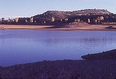
| Fool Hollow Lake Recreation Area | Navajo Navajo County, Arizona -2010:Whereas according to the 2010 U.S. Census Bureau:*49.3% White*0.9% Black*43.4% Native American*0.5% Asian*0.1% Native Hawaiian or Pacific Islander*2.5% Two or more races*3.3% Other races*10.8% Hispanic or Latino -2000:... |
800 | 6,300 | 1994 | Open | Surrounds a 150 acres (60.7 ha) mountain reservoir | |
| Fort Verde State Historic Park Fort Verde State Historic Park Fort Verde State Historic Park in the town of Camp Verde, Arizona is a small park that attempts to preserve parts of the Apache Wars-era fort as it appeared in the 1880s... |
Yavapai Yavapai County, Arizona -2010:Whereas according to the 2010 U.S. Census Bureau:*89.3% White*0.6% Black*1.7% Native American*0.8% Asian*0.1% Native Hawaiian or Pacific Islander*2.5% Two or more races*5.0% Other races*13.6% Hispanic or Latino -2000:... |
11 | 3,260 | 1970 | Open 5 days a week due to local partnership | Interprets the best-preserved Indian Wars-era fort in Arizona, active from 1871–1891 | |
| Homolovi State Park | Navajo Navajo County, Arizona -2010:Whereas according to the 2010 U.S. Census Bureau:*49.3% White*0.9% Black*43.4% Native American*0.5% Asian*0.1% Native Hawaiian or Pacific Islander*2.5% Two or more races*3.3% Other races*10.8% Hispanic or Latino -2000:... |
4,500 | 4,900 | 1986 | Open | Preserves several pueblo Pueblo Pueblo is a term used to describe modern communities of Native Americans in the Southwestern United States of America. The first Spanish explorers of the Southwest used this term to describe the communities housed in apartment-like structures built of stone, adobe mud, and other local material... ruins and other Ancestral Puebloan Ancient Pueblo Peoples Ancient Pueblo People or Ancestral Pueblo peoples were an ancient Native American culture centered on the present-day Four Corners area of the United States, comprising southern Utah, northern Arizona, northwest New Mexico, and southern Colorado... archaeological sites |
|
| Jerome State Historic Park Jerome State Historic Park Jerome State Historic Park is a state park of Arizona, USA, featuring the Douglas Mansion, built in 1916 by a family of influential mining entrepreneurs in Jerome, Arizona, a mining region in the northeast of the Black Hills, east Yavapai County... |
Yavapai Yavapai County, Arizona -2010:Whereas according to the 2010 U.S. Census Bureau:*89.3% White*0.6% Black*1.7% Native American*0.8% Asian*0.1% Native Hawaiian or Pacific Islander*2.5% Two or more races*5.0% Other races*13.6% Hispanic or Latino -2000:... |
5,000 | 1957 | Open 5 days a week due to local partnership | Honors the Douglas family of mining Mining Mining is the extraction of valuable minerals or other geological materials from the earth, from an ore body, vein or seam. The term also includes the removal of soil. Materials recovered by mining include base metals, precious metals, iron, uranium, coal, diamonds, limestone, oil shale, rock... entrepreneurs in their 1916 adobe mansion |
 |
|
| Kartchner Caverns State Park Kartchner Caverns State Park Kartchner Caverns State Park is a state park of Arizona, USA, featuring a show cave with of passages. The park is located south of the town of Benson and west of the north-flowing San Pedro River.... |
Cochise Cochise, Arizona Cochise is an unincorporated community located in Cochise County, Arizona, United States. The city was created alongside the Southern Pacific Railroad in the 1880s. The city was primarily a stop for coal and water which were needed for trains at the time. At its peak, the town had a population... |
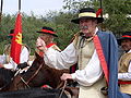
4,700 | 1988 | Open | Preserves a limestone cave kept in near-pristine condition since its discovery in 1974 | 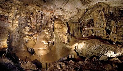 |
|
| Lake Havasu State Park Lake Havasu State Park Lake Havasu State Park is a state park located on Lake Havasu in Mohave County, Arizona, USA. The park provides outdoor recreation opportunities such as camping, boating, and fishing. The Arroyo-Camino Interpretive Garden displays local desert flora.... |
Mohave Mohave County, Arizona Mohave County is located in the northwestern corner of the U.S. state of Arizona. As of the 2010 census, its population was 200,186, an increase of 45,154 people since the 2000 census count of 155,032. The county seat is Kingman... |
928 | 480 | 1965 | Open | Provides water recreation on Lake Havasu Lake Havasu Lake Havasu is a large reservoir behind Parker Dam on the Colorado River, on the border between California and Arizona. Lake Havasu City sits on the lake's eastern shore. The lake has a capacity of . The concrete arch dam was built by the United States Bureau of Reclamation between 1934 and 1938... |
|
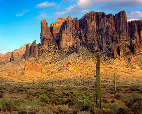
| Lost Dutchman State Park Lost Dutchman State Park Lost Dutchman State Park is a state park in central Arizona, USA.The park was scheduled to close on June 3, 2010. A man from Katy, Texas donated $8,000 so the park could stay open. This State Park has camping facilities, day use parking and acts as a trailhead for the trails leading into the Tonto... |
Pinal Pinal County, Arizona -2010:Whereas according to the 2010 U.S. Census Bureau:*72.4% White*4.6% Black*5.6% Native American*1.7% Asian*0.4% Native Hawaiian or Pacific Islander*3.8% Two or more races*11.5% Other races*28.5% Hispanic or Latino -2000:... |
320 | 2,000 | 1977 | Open | Faces the Superstition Mountains Superstition Mountains The Superstition Mountains , popularly referred to as "The Superstitions", are a range of mountains in Arizona located to the east of the Phoenix metropolitan area... , where the Lost Dutchman's Gold Mine Lost Dutchman's Gold Mine The Lost Dutchman Gold Mine is reportedly a very rich gold mine hidden in the Superstition Mountains, near Apache Junction, east of Phoenix, Arizona in the United States... is said to be hidden |
 |
| Lyman Lake State Park | Apache Apache County, Arizona -2010:Whereas according to the 2010 U.S. Census Bureau:*23.3% White*0.2% Black*72.9% Native American*0.3% Asian*0.0% Native Hawaiian or Pacific Islander*2.0% Two or more races*1.3% Other races*5.8% Hispanic or Latino -2000:... |
1,200 | 6,000 | 1960 | Closed due to budget cuts | Features Lyman Reservoir Lyman Reservoir The Lyman Reservoir is the largest lake in the region. Lyman Lake State Park, is located in and administered by the Apache-Sitgreaves National Forest, attracts anglers, as well as campers and water skiers year-round.-Location:... and a 14th Century pueblo Pueblo Pueblo is a term used to describe modern communities of Native Americans in the Southwestern United States of America. The first Spanish explorers of the Southwest used this term to describe the communities housed in apartment-like structures built of stone, adobe mud, and other local material... ruin |
 |
| McFarland State Historic Park McFarland State Historic Park McFarland State Historic Park is a small historic park located in downtown Florence, Arizona on the corner of Main and Ruggles Streets. The park consists of a preserved courthouse and other buildings dating to the Arizona Territory period. The original structure was built in 1878 with the addition... |
Pinal Pinal County, Arizona -2010:Whereas according to the 2010 U.S. Census Bureau:*72.4% White*4.6% Black*5.6% Native American*1.7% Asian*0.4% Native Hawaiian or Pacific Islander*3.8% Two or more races*11.5% Other races*28.5% Hispanic or Latino -2000:... |
1,500 | 1974 | Open due to local partnerships | Preserves a courthouse and jail from the Arizona Territory Arizona Territory The Territory of Arizona was an organized incorporated territory of the United States that existed from February 24, 1863 until February 14, 1912, when it was admitted to the Union as the 48th state.... era |
||
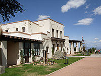
| Oracle State Park Oracle State Park Oracle State Park is a state park of Arizona, USA, preserving in the northeastern foothills of the Santa Catalina Mountains. The park is named after the nearby town of Oracle. Oracle State Park serves as a wildlife refuge, but has been closed to public access since October 2009 due to state budget... |
Pinal Pinal County, Arizona -2010:Whereas according to the 2010 U.S. Census Bureau:*72.4% White*4.6% Black*5.6% Native American*1.7% Asian*0.4% Native Hawaiian or Pacific Islander*3.8% Two or more races*11.5% Other races*28.5% Hispanic or Latino -2000:... |
3,948 | 3,700 | 1986 | Closed due to budget cuts | Features an environmental learning center, a historic ranchhouse, and wildlife habitat in the foothills of the Santa Catalina Mountains Santa Catalina Mountains The Santa Catalina Mountains, commonly referred to as the Catalina Mountains, are located north, and northeast of Tucson, Arizona, United States, on Tucson's north perimeter. The mountain range is the most prominent in the Tucson area, with the highest average elevation... |
|
| Patagonia Lake State Park Patagonia Lake State Park Patagonia Lake State Park is a state park of Arizona, USA, containing Patagonia Lake. The , lake located near Patagonia, Arizona, is a popular southern Arizona site for fishing, camping, boat rental, picnicking, hiking, and birding. Located inside the park is the recently established Sonoita... |
Santa Cruz Santa Cruz County, Arizona -2010:Whereas according to the 2010 U.S. Census Bureau:*73.5% White*0.4% Black*0.7% Native American*0.5% Asian*0.0% Native Hawaiian or Pacific Islander*2.0% Two or more races*22.9% Other races*82.8% Hispanic or Latino -2000:... |
2,658 | 3,750 | 1974 | Open | Provides recreational opportunities on 265 acres (107.2 ha) Patagonia Lake Patagonia Lake Patagonia Lake is located south of Patagonia, Arizona, and northeast of Nogales. The lake was created by damming Sonoita Creek. Facilities are maintained by Arizona State Parks.-Fish species:*Rainbow Trout*Largemouth Bass*Crappie*Sunfish*Channel Catfish... |
 |
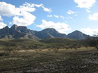
| Picacho Peak State Park Picacho Peak State Park Picacho Peak State Park is a state park of Arizona, USA, surrounding Picacho Peak. The park is located between Casa Grande and Tucson near Interstate 10 in Pinal County. Its centerpiece spire is visible from downtown Tucson, a distance of . The summit rises to above mean sea level... |
Pinal Pinal County, Arizona -2010:Whereas according to the 2010 U.S. Census Bureau:*72.4% White*4.6% Black*5.6% Native American*1.7% Asian*0.4% Native Hawaiian or Pacific Islander*3.8% Two or more races*11.5% Other races*28.5% Hispanic or Latino -2000:... |
3,747 | 2,000 | 1965 | Closed for summer 2011 | Features a distinctive 3374 feet (1,028.4 m) peak and spring wildflowers | |
| Red Rock State Park Red Rock State Park Red Rock State Park is a state park of Arizona, USA, featuring a red sandstone canyon outside the city of Sedona. This day-use park hosts numerous environmental education events for the public and for school or private groups.-Natural history:... |
Yavapai Yavapai County, Arizona -2010:Whereas according to the 2010 U.S. Census Bureau:*89.3% White*0.6% Black*1.7% Native American*0.8% Asian*0.1% Native Hawaiian or Pacific Islander*2.5% Two or more races*5.0% Other races*13.6% Hispanic or Latino -2000:... |
286 | 3,900 | 1986 | Open due to donations | Preserves a section of scenic red rock canyon | |
| Riordan Mansion State Historic Park Riordan Mansion State Historic Park Riordan Mansion State Historic Park is a historic site in the Kinlichi Knoll neighborhood of Flagstaff, Arizona, bordering Northern Arizona University.- Origin :... |
Coconino Coconino County, Arizona -2010:Whereas according to the 2010 U.S. Census Bureau:*61.7% White*1.2% Black*27.3% Native American*1.4% Asian*0.1% Native Hawaiian or Pacific Islander*3.1% Two or more races*5.2% Other races*13.5% Hispanic or Latino -2000:... |
5 | 6,900 | 1978 | Open 5 days a week | Interprets the 1904 adjoined homes of influential lumber-baron brothers Timothy and Michael Riordan | |
| Roper Lake State Park | Graham Graham County, Arizona -2010:Whereas according to the 2010 U.S. Census Bureau:*72.1% White*1.8% Black*14.4% Native American*0.5% Asian*0.1% Native Hawaiian or Pacific Islander*2.8% Two or more races*8.3% Other races*30.4% Hispanic or Latino -2000:... |
338 | 3,130 | 1972 | Open due to local partnership | Features a 32 acres (12.9 ha) fishing reservoir and a pond fed by a natural hot spring Hot spring A hot spring is a spring that is produced by the emergence of geothermally heated groundwater from the Earth's crust. There are geothermal hot springs in many locations all over the crust of the earth.-Definitions:... |
|
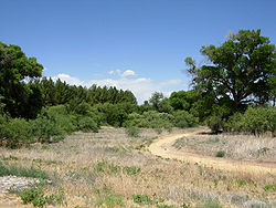
| San Rafael State Natural Area | Santa Cruz Santa Cruz County, Arizona -2010:Whereas according to the 2010 U.S. Census Bureau:*73.5% White*0.4% Black*0.7% Native American*0.5% Asian*0.0% Native Hawaiian or Pacific Islander*2.0% Two or more races*22.9% Other races*82.8% Hispanic or Latino -2000:... |
3,557 | 4,750 | 1999 | Not open to the public | Preserves a native grassland largely free of invasive plants. A former ranch complex is now a district on the National Register of Historic Places National Register of Historic Places The National Register of Historic Places is the United States government's official list of districts, sites, buildings, structures, and objects deemed worthy of preservation... |
|
| Slide Rock State Park Slide Rock State Park Slide Rock State Park is a state park of Arizona, USA, taking its name from a natural water slide formed by the slippery bed of Oak Creek. The park is located in Oak Creek Canyon north of Sedona. Slide Rock State Park is located on Coconino National Forest land and is co-managed by the Arizona... |
Coconino Coconino County, Arizona -2010:Whereas according to the 2010 U.S. Census Bureau:*61.7% White*1.2% Black*27.3% Native American*1.4% Asian*0.1% Native Hawaiian or Pacific Islander*3.1% Two or more races*5.2% Other races*13.5% Hispanic or Latino -2000:... |
43 | 4,930 | 1985 | Open | Features a natural waterslide and a historic apple orchard in Oak Creek Canyon Oak Creek Canyon Oak Creek Canyon is a river gorge located along the Mogollon Rim in northern Arizona located between the cities of Flagstaff and Sedona. The canyon is often described as a smaller cousin of the Grand Canyon because of its scenic beauty... |
|
| Sonoita Creek State Natural Area | Santa Cruz Santa Cruz County, Arizona -2010:Whereas according to the 2010 U.S. Census Bureau:*73.5% White*0.4% Black*0.7% Native American*0.5% Asian*0.0% Native Hawaiian or Pacific Islander*2.0% Two or more races*22.9% Other races*82.8% Hispanic or Latino -2000:... |
9,584 | 3,750 | 1994 | Open | Preserves a diverse transition zone around Sonoita Creek Sonoita Creek Sonoita Creek is a stream in Santa Cruz County, Arizona. It originates near and takes its name from the abandoned Pima mission in the high valley near Sonoita... adjacent to Patagonia Lake State Park Patagonia Lake State Park Patagonia Lake State Park is a state park of Arizona, USA, containing Patagonia Lake. The , lake located near Patagonia, Arizona, is a popular southern Arizona site for fishing, camping, boat rental, picnicking, hiking, and birding. Located inside the park is the recently established Sonoita... |
|
| Tombstone Courthouse State Historic Park Tombstone Courthouse State Historic Park Tombstone Courthouse State Historic Park, located in Tombstone, Arizona, United States, preserves the original Cochise County courthouse. The two-story building, constructed in 1882 in the Victorian style, is laid out in the shape of a cross and once contained various county offices, including... |
Cochise Cochise County, Arizona -2010:Whereas according to the 2010 U.S. Census Bureau:*78.5% White*4.2% Black*1.2% Native American*1.9% Asian*0.3% Native Hawaiian or Pacific Islander*4.0% Two or more races*9.6% Other races*32.4% Hispanic or Latino -2000:... |
4,539 | 1949 | Open due to local partnership | Preserves the historic 1882 courthouse, sheriff’s office, and jail | 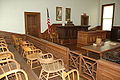 |
|
| Tonto Natural Bridge State Park Tonto Natural Bridge Tonto Natural Bridge is a natural arch in Arizona, USA, that is believed to be the largest natural travertine bridge in the world. The area surrounding the bridge has been made into a state park called Tonto Natural Bridge State Park, which is located off State Route 87, just north of Payson... |
Gila Gila County, Arizona -2010:Whereas according to the 2010 U.S. Census Bureau:*76.8% White*0.4% Black*14.8% Native American*0.5% Asian*0.1% Native Hawaiian or Pacific Islander*2.0% Two or more races*5.4% Other races*17.9% Hispanic or Latino -2000:... |
161 | 4,530 | 1969 | Open 5 days a week due to donations | Features the world's largest natural arch Natural arch A natural arch or natural bridge is a natural geological formation where a rock arch forms, with an opening underneath. Most natural arches form as a narrow ridge, walled by cliffs, become narrower from erosion, with a softer rock stratum under the cliff-forming stratum gradually eroding out until... made of travertine Travertine Travertine is a form of limestone deposited by mineral springs, especially hot springs. Travertine often has a fibrous or concentric appearance and exists in white, tan, and cream-colored varieties. It is formed by a process of rapid precipitation of calcium carbonate, often at the mouth of a hot... |
|
| Tubac Presidio State Historic Park Tubac Presidio State Historic Park Tubac Presidio State Historic Park, located in Tubac, Arizona, USA, preserves the ruins of the Presidio San Ignacio de Tubac and various other buildings, thereby presenting a timeline of human settlement in this Southern Arizona town... |
Santa Cruz Santa Cruz County, Arizona -2010:Whereas according to the 2010 U.S. Census Bureau:*73.5% White*0.4% Black*0.7% Native American*0.5% Asian*0.0% Native Hawaiian or Pacific Islander*2.0% Two or more races*22.9% Other races*82.8% Hispanic or Latino -2000:... |
3,500 | 1958 | Open 5 days a week due to local partnership | Preserves the ruins of the 1753 Presidio San Ignacio de Tubac Presidio San Ignacio de Tubac The Presidio of San Ignacio de Túbac or Fort Tubac was a Spanish built fortress. The fortification was established by the Spanish Army in 1753 at the site of present-day Tubac, Arizona.-Spanish Period:... , an 1885 schoolhouse, and other structures plus a museum |
 |
|
| Verde River Greenway State Natural Area Verde River The Verde River is the north and northwestern watershed of the Salt River–Verde River Watershed that co-join and enter the Gila River at Phoenix, Arizona, located in the U.S. state of Arizona... |
Yavapai Yavapai County, Arizona -2010:Whereas according to the 2010 U.S. Census Bureau:*89.3% White*0.6% Black*1.7% Native American*0.8% Asian*0.1% Native Hawaiian or Pacific Islander*2.5% Two or more races*5.0% Other races*13.6% Hispanic or Latino -2000:... |
480 | 3,300 | 1986 | Open | Preserves a 6 miles (9.7 km) section of the Verde River Verde River The Verde River is the north and northwestern watershed of the Salt River–Verde River Watershed that co-join and enter the Gila River at Phoenix, Arizona, located in the U.S. state of Arizona... adjacent to Dead Horse Ranch State Park Dead Horse Ranch State Park Dead Horse Ranch State Park is a state park of Arizona, USA, on the Verde River in an area known as the Verde River Greenway. Located at approximately elevation, Dead Horse Ranch State Park covers of land with of hiking trails, 150 campground sites and several picnic areas, along with 23 group... |
|
| Yuma Quartermaster Depot State Historic Park Yuma Quartermaster Depot State Historic Park Yuma Quartermaster Depot State Historic Park, formerly Yuma Crossing State Historic Park, and now one of the Yuma Crossing and Associated Sites on the National Register of Historic Places in the Yuma Crossing National Heritage Area. It is an Arizona state park in the city of Yuma, Arizona, USA.The... |
Yuma Yuma County, Arizona -2010:Whereas according to the 2010 U.S. Census Bureau:*70.4% White*2.0% Black*1.6% Native American*1.2% Asian*0.2% Native Hawaiian or Pacific Islander*3.8% Two or more races*20.8% Other races*59.7% Hispanic or Latino -2000:... |
120 | 1997 | Open | Interprets an 1864 U.S. Army facility that supplied 14 military posts around the Southwest | ||
| Yuma Territorial Prison State Historic Park Yuma Territorial Prison The Yuma Territorial Prison was a prison in the Arizona Territory of the United States and now in present day Yuma, Arizona. The Territorial Prison is one of the Yuma Crossing and Associated Sites on the National Register of Historic Places in the Yuma Crossing National Heritage Area.The site is... |
Yuma Yuma County, Arizona -2010:Whereas according to the 2010 U.S. Census Bureau:*70.4% White*2.0% Black*1.6% Native American*1.2% Asian*0.2% Native Hawaiian or Pacific Islander*3.8% Two or more races*20.8% Other races*59.7% Hispanic or Latino -2000:... |
120 | 1960 | Open | Interprets the famous Arizona Territory prison that operated from 1876 to 1909 | 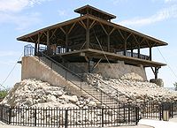 |
|