

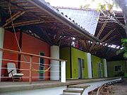
Liquid Jungle Lab (LJL) Panama
Encyclopedia
Mangrove
Mangroves are various kinds of trees up to medium height and shrubs that grow in saline coastal sediment habitats in the tropics and subtropics – mainly between latitudes N and S...
, estuarine and riparian (stream) habitats. The island and laboratory serve as a strategic base for ecologic research of the Coiba
Coiba
Coiba is the largest island in Central America, with an area of 503 square kilometers, off the Pacific coast of the Panamanian province of Veraguas. It is part of the Montijo District of that province.-History:...
National Park, a UNESCO World Heritage Site and Panama’s largest marine protected area. The tremendous biodiversity of the marine and terrestrial environments surrounding Isla Canales de Tierra allows visiting scientists to conduct multidisciplinary ecologic research in a pristine area and has even inspired a designer perfume fragrance, Fleur de Liane. The LJL was founded by Jean Pigozzi
Jean Pigozzi
Jean Pigozzi is a businessman, art collector, philanthropist and photographer. He was born in Paris as the son of Henri Pigozzi, founder of the French car maker Simca. Pigozzi studied in Paris and at Harvard University before working for the Gaumont Film Company and 20th Century Fox...
Swiss venture capitalist, photographer and art collector Contemporary African Art Collection.
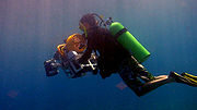
Research
Marine Science
Plankton
Plankton are any drifting organisms that inhabit the pelagic zone of oceans, seas, or bodies of fresh water. That is, plankton are defined by their ecological niche rather than phylogenetic or taxonomic classification...
community dynamics and marine larval ecology
Marine larval ecology
Marine larval ecology is the study of the factors influencing the dispersing larval stage exhibited by many marine invertebrates and fishes. Marine organisms with a larval stage usually release large numbers of larvae into the water column, where these larvae develop and grow for a certain period...
and transport, modeling internal waves and benthic structure, coral community architecture and diversity, synoptic chemical mapping, invasive sessile invertebrate species, mangrove and estuarine watersheds, and the effects of natural and anthropogenic nutrient input on primary production
Primary production
400px|thumb|Global oceanic and terrestrial photoautotroph abundance, from September [[1997]] to August 2000. As an estimate of autotroph biomass, it is only a rough indicator of primary production potential, and not an actual estimate of it...
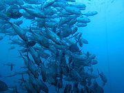
and fisheries along Pacific coastal zones.
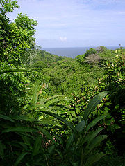
Terrestrial Science
Howler monkey
Howler monkeys are among the largest of the New World monkeys. Fifteen species are currently recognised. Previously classified in the family Cebidae, they are now placed in the family Atelidae. These monkeys are native to South and Central American forests...
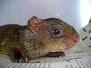
s (Allouatta palliata, and the endemic Coiba species Alouatta coibensis), capuchin monkeys (Cebus capucinus) coatis (Nasua narica), raccoons (Procyon cancrivorus), pacas (Agouti paca), agoutis or nueques (Dasyprocta sp), tayras (Eira barbara), bats (Glossophaga soricina &Carollia castanea) sloths (Bradypus variegatus) margays (Leopardus wiedii) and white-tailed deer (Odocoileus virginianus). Besides the thousands of species of plants and insects endemic to this region of the tropical Americas, many reptile and amphibian species are also found on the island. Even occasionally the rare jungle cat (Leopardus pardalis) is spotted in the dense jungle surrounding nearby Bahia Honda and Pixvae. In 2004 botanists, herpetologists, entomologists, ornithologists, and biologists convened to create the first comprehensive catalog of tropical plants, reptiles, insect, birds, and mammal diversity of this Pacific Coastal region.
Regional Geography and Geology
Geography of PanamaGeography of Panama
Panama is a country located in the Central America region of North America, bordering both the Caribbean Sea and the North Pacific Ocean, between Colombia and Costa Rica. Panama is located on the narrow and low Isthmus of Panama. This S-shaped isthmus is situated between 7° and 10° north latitude...
The Gulf of Chiriquí contains several prominent, offshore island complexes including Isla Coiba (493 km2), Isla Cebaco (80 km2) Islas Ladrones, Islas Secas, and Islas Contreras. Other islands like Jicarón, Leones, Gobernadora, Verde, Canales de Afuera, Ranchería, Papagayo, Canales de Tierra, and Jicarita are part of a group of more than forty smaller island clusters scattered near the coast. Coastal areas in the gulf are a mélange of mid to late Tertiary volcanics, and much newer Quaternary period alluvial sedimentary series. Smaller island clusters are predominantly basalt outcrops once associated with the mainland before sea level rise. Coiba Island, the largest in the region, shares geomorphologies similar to the mainland Azuero peninsula .
Climate and Oceanographic conditions of Pacific Panama.
The climate of Panamá is largely affected by the position of a low atmospheric pressure zone known as the Intertropical Convergence ZoneIntertropical Convergence Zone
The Intertropical Convergence Zone , known by sailors as The Doldrums, is the area encircling the earth near the equator where winds originating in the northern and southern hemispheres come together....
(ITCZ) which also affects seasonal evolution of geostrophic currents in the Panamá Bight. During the rainy season (December through May), the ITCZ is located to the North of Panamá and produces light and variable winds and ocean circulation in the Panamá Bight is anticyclonic (west) which creates a southerly flowing coastal current. As a result of these punctuated seasonal movements of the ITCZ, Panamá experiences high seasonal rainfall often reaching more than 3000 mm/yr. Starting in October and continuing into the dry season (January to March) the ITCZ moves South of Panamá, producing a dominant period of northeasterly tradewinds known as the Panamá Jet , which results in a reversal of water circulation and becomes a cyclonic gyre
Gyre
A gyre in oceanography is any large system of rotating ocean currents, particularly those involved with large wind movements. Gyres are caused by the Coriolis Effect; planetary vorticity along with horizontal and vertical friction, which determine the circulation patterns from the wind curl...
with a coastal current flowing to the north. Upwelling
Upwelling
Upwelling is an oceanographic phenomenon that involves wind-driven motion of dense, cooler, and usually nutrient-rich water towards the ocean surface, replacing the warmer, usually nutrient-depleted surface water. The increased availability in upwelling regions results in high levels of primary...
develops in the Gulf of Panama
Gulf of Panama
The Gulf of Panama is a gulf in the Pacific Ocean, near the southern coast of Panama. It has a maximum width of , a maximum depth of and the size of . The Panama Canal connects the Gulf of Panama with the Caribbean Sea and the Atlantic Ocean...
during the dry season when northeast tradewinds from the Caribbean blow over to the Pacific through a physiographic gap in the central mountain range which divides the Isthmus. This wind stress creates seasonal Ekman spiral
Ekman spiral
The Ekman spiral refers to a structure of currents or winds near a horizontal boundary in which the flow direction rotates as one moves away from the boundary. It derives its name from the Swedish oceanographer Vagn Walfrid Ekman...
pumping and displaces nutrient-poor coastal surface water with cool, nutrient rich, water masses.
Seasonal effects on Marine Life
Plankton
Plankton are any drifting organisms that inhabit the pelagic zone of oceans, seas, or bodies of fresh water. That is, plankton are defined by their ecological niche rather than phylogenetic or taxonomic classification...
production leading to blooms of centric, colonial, and penate diatoms and dinoflagellates. Zooplankton populations often respond to this by subsequently increasing growth and reproduction rates. Scientists are now able to quantify the abundance and diversity of these microscopic organisms in-situ with sensors such as the Video Plankton Recorder (a specialized underwater microscope and imaging system).
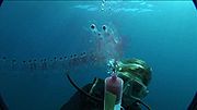
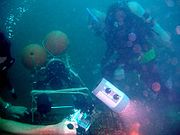
Panama Liquid Jungle Underwater Tropical Observatory PLUTO
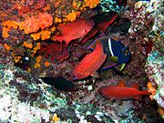
Coral Reefs of the Eastern Tropical Pacific (ETP)
Oligotroph
An oligotroph is an organism that can live in an environment that offers very low levels of nutrients. They may be contrasted with copiotrophs, which prefer nutritionally rich environments...
ic (low nutrient) water in a narrow temperature and salinity range. Littoral
Littoral
The littoral zone is that part of a sea, lake or river that is close to the shore. In coastal environments the littoral zone extends from the high water mark, which is rarely inundated, to shoreline areas that are permanently submerged. It always includes this intertidal zone and is often used to...
areas located along the Southern Isthmus of Panamá
Isthmus of Panama
The Isthmus of Panama, also historically known as the Isthmus of Darien, is the narrow strip of land that lies between the Caribbean Sea and the Pacific Ocean, linking North and South America. It contains the country of Panama and the Panama Canal...
demonstrate highly complex ecological interactions and distributions of endemic and migratory marine species due in part to the overlap of continental ecotones, tropical weather patterns and the convergence of powerful sea currents. In the Republic of Panamá, there is estimated 290 km2 of reefs along both Caribbean and Pacific coasts, however much higher diversity (about 68 hard coral species) occurs in the Caribbean, compared to 33 known species from 11 genera living along the Pacific coast.
The Eastern Tropical Pacific (ETP) is a biotope known for intrinsically low coral species diversity which unfortunately enhances the potential threats to these coral reef systems. Besides the direct effects of overfishing, anchor damage, and coral mining, terrestrial land use affects coral reef habitats in more indirect ways. Panamá experiences high seasonal rainfall (3000 mm/yr.) and reefs can be severely impacted if corals are chronically exposed to the runoff of nutrients originating from deforestation and soil erosion, fertilizers, pesticides or untreated sewage. In addition to being a primary area for cattle ranching and agriculture, unregulated construction, septic waste increase and local coastal population expansion poses a tangible threat to the biological integrity of coral reefs surrounding the Coiba Island Marine Protected Area (MPA).
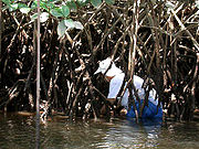
Mangrove
Mangroves are various kinds of trees up to medium height and shrubs that grow in saline coastal sediment habitats in the tropics and subtropics – mainly between latitudes N and S...
areas of Bahia Honda, Pixvae, and Puerto Mutis are important for the health of the local reefs, because mangroves not only filter the nutrients emptying onto reefs, but are important nurseries for juvenile fish, fish larvae crustaceans (i.e. shrimp), and other invertebrates that serve as critical food sources and spawning grounds for the offshore marine systems (i.e. Coiba and Cebaco islands). Scientists from around the world use the Liquid Jungle Lab facilities to study these reef systems in greater detail in order to establish ecologic baselines and understand natural and human impacts to the fish and marine life that rely on these habitats.
Reef Building Corals (Scleractinia
Scleractinia
Scleractinia, also called stony corals, are exclusively marine animals; they are very similar to sea anemones but generate a hard skeleton. They first appeared in the Middle Triassic and replaced tabulate and rugose corals that went extinct at the end of the Permian...
) of the Gulf of Chiriqui including Bahia Honda to Coiba Island marine zones
Family Agariciidae: Pavona clavus, Gardineroseris planulata, Pavona gigantea, Pavona varians, Pavona Chiriquíensis, Pavona frondifera, Pavona maldivensis Pocilloporidae: Pocillopora elegans, Pocillopora damicornis, Pocillorpora capitata, Pocillorpora eydouxi; Poritidae: Porites lobata; Siderastreidae: Psammacora stellata. Fungiidae: Cyclocerus curvata Milleporadea: Millepora intricata Dendrophyllidae: Tubastraea coccinea
Further reading
Bibliography of scientific research conducted at the Liquid Jungle Lab, PanamaAlmany, G. R., M.L. Berumen, S.R. Thorrold, S. Planes, and G.P. Jones. Larval dispersal, marine reserves and the replenishment of fish populations. (Accepted pending suitable revision) Science
Bowen, J.L. and Ivan Valiela (2008) Using δ15N to Assess Coupling between Watersheds and Estuaries in Temperate and Tropical Regions. Journal of Coastal Research Vol 24:3; pp. 804–813.
Camilli, Luis, O. Pizarro, and R. Camilli (2008) Advancing spatial-temporal continuity in coral reef ecosystem pattern detection: The morphology, distribution and chemical environments of coral habitats encompassing Coiba National Park, Panamá. Proceedings of the 11th International Coral Reef Symposium, Ft. Lauderdale, Florida, 7–11 July 2008, Session number 16
Camilli Richard, O. Pizarro, and L. Camilli (2007) Rapid Swath Mapping of Reef Ecology and Associated Water Column Chemistry in the Gulf of Chiriquí, Panamá On the Edge of Tomorrow: MTS/IEEE-OES Oceans Conference.
Carman Mary R., S.J. Molyneaux, R. Ji, and S.M. Sievert (2007) Ascidians of the southern Gulf of Chiriqui, Pacific-Panama: A native fauna at risk to bioinvasion. Fifth International Conference on Marine Bioinvasions.
Carman, Mary, S. Bullard, S. Molyneaux, R. Ji, A. Goodwin, E. Baker, and S. Sievert. Ascidian faunas of the island chain Isla Canales de Tierra to Coiba, southern Gulf of Chiriqui and south entrance to the Panama Canal, Pacific coast of Panama. (in prep)
Castroviejo S., and A. Ibanez (2003) Estudio Sobre la Biodiversidad de la Region de Bahia Honda (Veraguas, Panama) Inventario de Biodiversidad. Real Jardin Botanico(CSIC) (133).
Gallager, Scott M., S. Lerner, E. Miller, A.D. York, and A. Girard. Design, installation, and the first two years of operation of an underwater observatory on the western Panamanian shelf. (submitted)
Gallager, Scott M., A.D. York, C. Mingione and S. Lerner. Plankton community structure in the Gulf of Chiriqui, Pacific-Panama, as modulated by upwelling and large internal waves. (in prep)
Pineda, J., Reyns, N., Starczak, V.R., 2009. Complexity and simplification in understanding recruitment in benthic populations. Popul Ecol 51, 17-32.
Thorrold, Simon R., G.P. Jones, S. Planes, and J. A. Hare. (2006) Transgenerational marking of embryonic otoliths in marine fishes using barium stable isotopes. Can. J. Fish. Aquat. Sci. 63: 1193-1197.
Starczak, Victoria, P. Perez-Brunius, J. Pineda, J. Gyory, and H. Levine. The role of season, salinity and flushing in determine barnacle distributions in tow adjacent mangrove coastal lagoons. (in prep)
External links
- Liquid Jungle Laboratory official website
- PLUTO website (The Panama Liquid Jungle Laboratory Underwater Tropical Observatory)