
Liodora
Encyclopedia
Liodora is a small village in Arcadia
, in the Peloponnese
area of Greece
. Liodora is part of the municipal unit of Iraia
. Its 2001 population was 117. Liodora is located west of Tripoli
, northwest of Karytaina
and Atsicholos
, northeast of Andritsaina
, southeast of Olympia
and east-southeast of Pyrgos
Outside the village there is an ancient cheese factory and water spring named Koura (Greek: Κούρα).
The entire population prior to the late-20th century were entirely rural farmers. Today, farmers are the minority of the population.
s, citrus
, fruits, vegetables and other crops, several common crops are rarely common. The village can be seen as far as to the north and east.
Liodora has several rural roads and approximately 10 km of hydro lines and 3 km of paved roads.
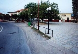
Its residential houses and buildings are within the main road and it is about 200 to 300 m long wide at the centre. Much of the houses were stone built until the 1960s. Electricity arrived in the same year. Vehicles arrived in the 1970s, the pavement of the main road and television arrived in the 1980s and computer and internet are rarely known in the beginning of the 21st century and up to date technology are not seen.
Arcadia
Arcadia is one of the regional units of Greece. It is part of the administrative region of Peloponnese. It is situated in the central and eastern part of the Peloponnese peninsula. It takes its name from the mythological character Arcas. In Greek mythology, it was the home of the god Pan...
, in the Peloponnese
Peloponnese
The Peloponnese, Peloponnesos or Peloponnesus , is a large peninsula , located in a region of southern Greece, forming the part of the country south of the Gulf of Corinth...
area of Greece
Greece
Greece , officially the Hellenic Republic , and historically Hellas or the Republic of Greece in English, is a country in southeastern Europe....
. Liodora is part of the municipal unit of Iraia
Iraia
Iraia is a former municipality in Arcadia, Peloponnese, Greece. Since the 2011 local government reform it is part of the municipality Gortynia, of which it is a municipal unit. It consists of 27 villages. Population 3,063 . The seat of the municipality was in Paloumpa. The municipality is named...
. Its 2001 population was 117. Liodora is located west of Tripoli
Tripoli, Greece
Tripoli is a city of about 25,000 inhabitants in the central part of the Peloponnese, in Greece. It is the capital of the prefecture of Arcadia and the centre of the municipality of Tripolis, pop...
, northwest of Karytaina
Karytaina
Karytaina is a village in Arcadia, Greece. It was the seat of the former municipality Gortyna. Karytaina had a 2001 population of 204 for the village and 257 for the municipal district...
and Atsicholos
Atsicholos
-Nearest places:*Maratha , west*Stemnitsa, northeast*Elliniko, east*Karytaina, south-Information:Its main production are olives, citrus, fruits, vegetables and other crops, several common crops are rarely common...
, northeast of Andritsaina
Andritsaina
Andritsaina is a town and a former municipality in Elis, West Greece, Greece. Since the 2011 local government reform it is part of the municipality Andritsaina-Krestena, of which it is a municipal unit...
, southeast of Olympia
Olympia, Greece
Olympia , a sanctuary of ancient Greece in Elis, is known for having been the site of the Olympic Games in classical times, comparable in importance to the Pythian Games held in Delphi. Both games were held every Olympiad , the Olympic Games dating back possibly further than 776 BC...
and east-southeast of Pyrgos
Pyrgos, Elis
Pyrgos is the capital of the Elis peripheral unit in Greece. It is named after a local tower. The city is located in the western part of the Peloponnese, in the middle of a plain near the Ionian Sea. It is 96 km away from Patras via Greek National Road 9, 320 km from Athens, and...
Outside the village there is an ancient cheese factory and water spring named Koura (Greek: Κούρα).
The entire population prior to the late-20th century were entirely rural farmers. Today, farmers are the minority of the population.
Geography
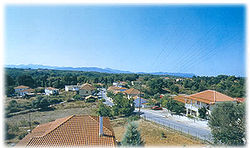
Liodora is situated in a hilly plateau and features several hills. The view to the south are blocked by a mountain slope. Kryonero has several valleys around the area and contains forests, grasslands and bushes are also around the area. as well as farmlands.Information
Its main production are oliveOlive
The olive , Olea europaea), is a species of a small tree in the family Oleaceae, native to the coastal areas of the eastern Mediterranean Basin as well as northern Iran at the south end of the Caspian Sea.Its fruit, also called the olive, is of major agricultural importance in the...
s, citrus
Citrus
Citrus is a common term and genus of flowering plants in the rue family, Rutaceae. Citrus is believed to have originated in the part of Southeast Asia bordered by Northeastern India, Myanmar and the Yunnan province of China...
, fruits, vegetables and other crops, several common crops are rarely common. The village can be seen as far as to the north and east.
Liodora has several rural roads and approximately 10 km of hydro lines and 3 km of paved roads.
Its residential houses and buildings are within the main road and it is about 200 to 300 m long wide at the centre. Much of the houses were stone built until the 1960s. Electricity arrived in the same year. Vehicles arrived in the 1970s, the pavement of the main road and television arrived in the 1980s and computer and internet are rarely known in the beginning of the 21st century and up to date technology are not seen.
Population
| Year | Population |
|---|---|
| 1981 | 112 |
| 1991 | 111 |
| 2001 | 114 |
History
The village used to have a large population before the beginning of the 20th century.