
Lilyfield, New South Wales
Encyclopedia
Lilyfield is a small suburb
in the Inner West
of Sydney
, in the state of New South Wales
, Australia
. Lilyfield is located 6 kilometres west of the Sydney central business district
, in the local government area of the Municipality of Leichhardt
.
Lilyfield is nestled in between the suburbs of Annandale
, Rozelle
and Leichhardt
and is bounded to the west by Iron Cove. Originally a working-class area, today Lilyfield like many inner-city suburbs is becoming increasingly gentrified
. Property investors, eager to capitalise on the suburb's proximity to the Sydney CBD, have purchased many of the original workers' cottages to renovate or develop. Although predominantly middle class
, the suburb still retains some of its working-class roots and like its neighbouring suburbs, is home to people from diverse cultural and ethnic backgrounds.
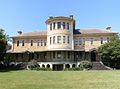 The most dominant landmark in the area is the former Callan Park hospital. This was built on land acquired from the Callan Estates, a property between Balmain Road and Iron Cove. A psychiatric hospital was designed by James Barnet
, the government architect, based on an asylum in Kent and utilising the principles of Dr Kirkbride, an American psychiatrist. Completed in 1884, the hospital was known until 1914 as the Callan Park Hospital for the Insane; the main part of the hospital, a cluster of sandstone buildings, was called the Kirkbride complex.
More recently, the Kirkbride complex became the home of the Sydney College of the Arts
, and the hospital functions were confined to the western buildings. This is now known as Rozelle Hospital. The Kirkbride complex is listed on the Register of the National Estate
.
After the construction of the City West Link Road
in the 1990s, the suburb was effectively split into two parts. One half on the Rozelle side of the road, the other half on the Leichhardt side. This dramatic change in the geography did much to disrupt the sense of community in the relatively secluded suburb and almost led to its being subsumed into the neighbouring suburbs.
, and became a bus terminus when that system was abolished. The 470 bus service runs from Lilyfield to the Sydney CBD via Glebe, Broadway and George Street. The 370 service runs from Lilyfield to Coogee via Newtown. The 440 service runs to the CBD via Norton Street, Leichhardt and Broadway. The 445 service runs from Rozelle to railway station, via Norton Street
.
Lilyfield station, in Catherine Street, is a terminus of the Metro Light Rail
. The station opened in 2000, using a disused spur of a goods railway line from Central railway station
. Another railway line, running from White Bay to Dulwich Hill
, is also no longer used and an extension of the light rail further southwest to Dulwich Hill has been proposed http://www.greenway.com.au/, with a bicycle rail trail
alongside.
The City West Link Road
is a major arterial road, which is part of Metroad 4
and crosses the ANZAC Bridge
. It provides an alternative route to Parramatta Road
for the Sydney CBD from Ashfield
.
Bicycle routes in Lilyfield include part of the regional east-west route from Parramatta to the Sydney CBD, along Lilyfield Road, the Bay Run path around Iron Cove, and the Whites Creek path, which provides a north-south route from Parramatta Road
to The Crescent at White Bay
.
, as was Leichhardt Oval. the home of the Wests Tigers
/Balmain Tigers
Suburb
The word suburb mostly refers to a residential area, either existing as part of a city or as a separate residential community within commuting distance of a city . Some suburbs have a degree of administrative autonomy, and most have lower population density than inner city neighborhoods...
in the Inner West
Inner West (Sydney)
The Inner West is a general term which is used to describe the metropolitan area directly to the west of the Sydney central business district, New South Wales, Australia...
of Sydney
Sydney
Sydney is the most populous city in Australia and the state capital of New South Wales. Sydney is located on Australia's south-east coast of the Tasman Sea. As of June 2010, the greater metropolitan area had an approximate population of 4.6 million people...
, in the state of New South Wales
New South Wales
New South Wales is a state of :Australia, located in the east of the country. It is bordered by Queensland, Victoria and South Australia to the north, south and west respectively. To the east, the state is bordered by the Tasman Sea, which forms part of the Pacific Ocean. New South Wales...
, Australia
Australia
Australia , officially the Commonwealth of Australia, is a country in the Southern Hemisphere comprising the mainland of the Australian continent, the island of Tasmania, and numerous smaller islands in the Indian and Pacific Oceans. It is the world's sixth-largest country by total area...
. Lilyfield is located 6 kilometres west of the Sydney central business district
Sydney central business district
The Sydney central business district is the main commercial centre of Sydney, New South Wales, Australia. It extends southwards for about 3 kilometres from Sydney Cove, the point of first European settlement. Its north–south axis runs from Circular Quay in the north to Central railway station in...
, in the local government area of the Municipality of Leichhardt
Municipality of Leichhardt
The Municipality of Leichhardt is a Local Government Area in the inner-west of Sydney, in state of New South Wales, Australia.-History:The Municipality of Leichhardt stands on land that traditionally belonged to the Gadigal and Wangal people, of the Eora nation...
.
Lilyfield is nestled in between the suburbs of Annandale
Annandale, New South Wales
Annandale is a suburb of Inner West Sydney in the state of New South Wales, Australia. Annandale is located within 3-5 kilometres west of the Sydney central business district and is part of the local government area of the Municipality of Leichhardt. Annandale's northern end lies on Rozelle Bay,...
, Rozelle
Rozelle, New South Wales
Rozelle is a suburb in the inner west of Sydney, in the state of New South Wales, Australia. It is located 4 kilometres west of the Sydney central business district, in the local government area of the Municipality of Leichhardt....
and Leichhardt
Leichhardt, New South Wales
Leichhardt is a suburb in the inner-west of Sydney in New South Wales, Australia. Leichhardt is located 5 kilometres west of the Sydney central business district and is the administrative centre for the local government area of the Municipality of Leichhardt...
and is bounded to the west by Iron Cove. Originally a working-class area, today Lilyfield like many inner-city suburbs is becoming increasingly gentrified
Gentrification
Gentrification and urban gentrification refer to the changes that result when wealthier people acquire or rent property in low income and working class communities. Urban gentrification is associated with movement. Consequent to gentrification, the average income increases and average family size...
. Property investors, eager to capitalise on the suburb's proximity to the Sydney CBD, have purchased many of the original workers' cottages to renovate or develop. Although predominantly middle class
Middle class
The middle class is any class of people in the middle of a societal hierarchy. In Weberian socio-economic terms, the middle class is the broad group of people in contemporary society who fall socio-economically between the working class and upper class....
, the suburb still retains some of its working-class roots and like its neighbouring suburbs, is home to people from diverse cultural and ethnic backgrounds.
History
Popular belief has it that the area was once farmland and was named for the lilies that reportedly grew in the fields. However, its name origin remains unclear. Lilyfield was originally part of the suburb of Leichhardt.James Barnet
James Johnstone Barnet was the Colonial Architect for New South Wales from 1862 - 1890.-Life and career:Barnet was born at Almericlose, Arbroath, Scotland. The son of a builder, he was educated at the local high school...
, the government architect, based on an asylum in Kent and utilising the principles of Dr Kirkbride, an American psychiatrist. Completed in 1884, the hospital was known until 1914 as the Callan Park Hospital for the Insane; the main part of the hospital, a cluster of sandstone buildings, was called the Kirkbride complex.
More recently, the Kirkbride complex became the home of the Sydney College of the Arts
Sydney College of the Arts
The Sydney College of the Arts in Rozelle, Sydney, Australia is the visual arts faculty of the University of Sydney. It is housed in the Kirkbride complex, a cluster of sandstone buildings designed by James Barnet, the government architect in the late 19th century...
, and the hospital functions were confined to the western buildings. This is now known as Rozelle Hospital. The Kirkbride complex is listed on the Register of the National Estate
Register of the National Estate
The Register of the National Estate is a listing of natural and cultural heritage places in Australia. The listing was initially compiled between 1976 and 2003 by the Australian Heritage Commission. The register is now maintained by the Australian Heritage Council...
.
After the construction of the City West Link Road
City West Link Road
City West Link Road is a link road in Sydney, Australia. It makes up a section of Metroad 4 between Leichhardt, Haberfield and Five Dock. As such, it provides an alternative route to Parramatta Road into Sydney's CBD from the Inner-West....
in the 1990s, the suburb was effectively split into two parts. One half on the Rozelle side of the road, the other half on the Leichhardt side. This dramatic change in the geography did much to disrupt the sense of community in the relatively secluded suburb and almost led to its being subsumed into the neighbouring suburbs.
Transport
Lilyfield was the terminus of a tram line in the original Sydney tram systemTrams in Sydney
The Sydney tramway network once served Sydney, the capital city of New South Wales, Australia. In its heyday, it was the largest in Australia, the second largest in the Commonwealth , and one of the largest in the world. It was extremely intensively worked, with about 1,600 cars in service at any...
, and became a bus terminus when that system was abolished. The 470 bus service runs from Lilyfield to the Sydney CBD via Glebe, Broadway and George Street. The 370 service runs from Lilyfield to Coogee via Newtown. The 440 service runs to the CBD via Norton Street, Leichhardt and Broadway. The 445 service runs from Rozelle to railway station, via Norton Street
Norton Street, Sydney
Norton Street, Sydney is located in the suburb of Leichhardt in Sydney, New South Wales, Australia. It is located 5 kilometres west of the Sydney central business district and is the main commercial street in the suburb....
.
Lilyfield station, in Catherine Street, is a terminus of the Metro Light Rail
Metro Light Rail
The Metro Light Rail is the only currently operating light rail line in Sydney. The line opened on 31 August 1997, mostly along the route of an unused goods railway line, to serve the redeveloped inner-city areas of Darling Harbour, Ultimo and Pyrmont, and was extended in 2000 to serve some of...
. The station opened in 2000, using a disused spur of a goods railway line from Central railway station
Central railway station, Sydney
Central Railway Station, the largest railway station in Australia, is at the southern end of the Sydney CBD. It services almost all the lines on the CityRail network, and is the major terminus for interurban and interstate rail services...
. Another railway line, running from White Bay to Dulwich Hill
Dulwich Hill, New South Wales
Dulwich Hill is a residential suburb in the Inner West of Sydney, in the state of New South Wales, Australia. Dulwich Hill is located 9 kilometres south-west of the Sydney central business district, in the local government area of Marrickville Council...
, is also no longer used and an extension of the light rail further southwest to Dulwich Hill has been proposed http://www.greenway.com.au/, with a bicycle rail trail
Rail trail
A rail trail is the conversion of a disused railway easement into a multi-use path, typically for walking, cycling and sometimes horse riding. The characteristics of former tracks—flat, long, frequently running through historical areas—are appealing for various development. The term sometimes also...
alongside.
The City West Link Road
City West Link Road
City West Link Road is a link road in Sydney, Australia. It makes up a section of Metroad 4 between Leichhardt, Haberfield and Five Dock. As such, it provides an alternative route to Parramatta Road into Sydney's CBD from the Inner-West....
is a major arterial road, which is part of Metroad 4
Metroad 4
Metroad 4 is a Metroad in Sydney, New South Wales, Australia. It connects the inner-west of Sydney with the outer western suburbs. It mostly follows what was previously National Highway 32 from the Western Distributor in the CBD, west to the Great Western Highway at Lapstone...
and crosses the ANZAC Bridge
ANZAC Bridge
The ANZAC Bridge or Anzac Bridge , replacing the earlier Glebe Island Bridge, is a large cable-stayed bridge spanning Johnstons Bay between Pyrmont and Glebe Island in proximity to the central business district of Sydney, Australia...
. It provides an alternative route to Parramatta Road
Parramatta Road
.Parramatta Road is the major historical east-west artery of metropolitan Sydney, Australia, connecting the Sydney with Parramatta. It is the eastern-most part of the Great Western Highway. Much of its traffic has been diverted to modern expressways such as the M4 and the City West Link...
for the Sydney CBD from Ashfield
Ashfield, New South Wales
Ashfield is a suburb in the inner-west of Sydney, in the state of New South Wales, Australia. Ashfield is about 9 kilometres south-west of the Sydney central business district and is the administrative centre for the local government area of the Municipality of Ashfield.The official name for the...
.
Bicycle routes in Lilyfield include part of the regional east-west route from Parramatta to the Sydney CBD, along Lilyfield Road, the Bay Run path around Iron Cove, and the Whites Creek path, which provides a north-south route from Parramatta Road
Parramatta Road
.Parramatta Road is the major historical east-west artery of metropolitan Sydney, Australia, connecting the Sydney with Parramatta. It is the eastern-most part of the Great Western Highway. Much of its traffic has been diverted to modern expressways such as the M4 and the City West Link...
to The Crescent at White Bay
White Bay, New South Wales
White Bay is a bay on Sydney Harbour with a surrounding locality near the suburbs of Balmain and Rozelle in the Inner West of Sydney, New South Wales, Australia.-History:...
.
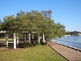
Parks and recreation
Leichhardt Park, which includes the Leichhardt Park Aquatic Centre was originally part of LeichhardtLeichhardt, New South Wales
Leichhardt is a suburb in the inner-west of Sydney in New South Wales, Australia. Leichhardt is located 5 kilometres west of the Sydney central business district and is the administrative centre for the local government area of the Municipality of Leichhardt...
, as was Leichhardt Oval. the home of the Wests Tigers
Wests Tigers
The Wests Tigers are an Australian professional rugby league football club based in Sydney's mid-western suburbs. They have competed in the National Rugby League since they were formed at the end of the 1999 season as a joint-venture club between the Balmain Tigers and the Western Suburbs...
/Balmain Tigers
Balmain Tigers
The Balmain Tigers are a rugby league football club based in the inner-western Sydney suburb of Balmain. They were a founding member of the New South Wales Rugby League and one of the most successful in the history of the premiership, with eleven titles...