
Lewis Township, Clay County, Indiana
Encyclopedia
Lewis Township is one of eleven townships
in Clay County, Indiana
. As of the 2000 census
, its population was 1,510.
(This list is based on USGS data and may include former settlements.)
Township (United States)
A township in the United States is a small geographic area. Townships range in size from 6 to 54 square miles , with being the norm.The term is used in three ways....
in Clay County, Indiana
Clay County, Indiana
Clay County is a county located in the U.S. state of Indiana. As of 2010, the population was 26,890. The county seat is Brazil. Clay County is included in the Terre Haute, Indiana, Metropolitan Statistical Area.- History :Clay County was formed in 1825...
. As of the 2000 census
United States Census, 2000
The Twenty-second United States Census, known as Census 2000 and conducted by the Census Bureau, determined the resident population of the United States on April 1, 2000, to be 281,421,906, an increase of 13.2% over the 248,709,873 persons enumerated during the 1990 Census...
, its population was 1,510.
Geography
Lewis Township covers an area of 44.21 square miles (114.5 km²); 0.16 square mile (0.4143980976 km²) (0.36 percent) of this is water. Muir Lake and Muir Lake are in this township.Unincorporated towns
- Bogle CornerBogle Corner, IndianaBogle Corner is an unincorporated community in Lewis Township, Clay County, Indiana. It is part of the Terre Haute Metropolitan Statistical Area....
- BrunswickBrunswick, IndianaBrunswick is an unincorporated town in Hanover Township, Lake County, Indiana....
- Buchanan CornerBuchanan Corner, IndianaBuchanan Corner is an unincorporated community in Lewis Township, Clay County, Indiana. It is part of the Terre Haute Metropolitan Statistical Area....
- CoalmontCoalmont, IndianaCoalmont is an unincorporated town in Lewis Township, Clay County, Indiana. It is part of the Terre Haute Metropolitan Statistical Area....
- HowesvilleHowesville, IndianaHowesville is an unincorporated town in Lewis Township, Clay County, Indiana. It is part of the Terre Haute Metropolitan Statistical Area....
(This list is based on USGS data and may include former settlements.)
Adjacent townships
- Perry TownshipPerry Township, Clay County, IndianaPerry Township is one of eleven townships in Clay County, Indiana. As of the 2000 census, its population was 960.-Geography:Perry Township covers an area of ; of this is water.-Unincorporated towns:* Art* Cory* Hickory Island...
(north) - Harrison TownshipHarrison Township, Clay County, IndianaHarrison Township is one of eleven townships in Clay County, Indiana. As of the 2000 census, its population was 2,366.-Geography:Harrison Township covers an area of ; of this is water.-Unincorporated towns:* Barrick Corner* Eel River...
(northeast) - Smith Township, Greene CountySmith Township, Greene County, IndianaSmith Township is one of fifteen townships in Greene County, Indiana, USA. As of the 2000 census, its population was 344.-Geography:Smith Township covers an area of ; of this, or 0.12 percent is water...
(southeast) - Wright Township, Greene CountyWright Township, Greene County, IndianaWright Township is one of fifteen townships in Greene County, Indiana, USA. As of the 2000 census, its population was 4,224.-Geography:Wright Township covers an area of ; of this, or 1.46 percent is water...
(south) - Jackson Township, Sullivan CountyJackson Township, Sullivan County, IndianaJackson Township is one of nine townships in Sullivan County, Indiana, USA. As of the 2000 census, its population was 1,720.-Geography:According to the United States Census Bureau, Jackson Township covers an area of ; of this, is land and is water.-Adjacent townships:* Pierson Township, Vigo...
(west) - Pierson Township, Vigo CountyPierson Township, Vigo County, IndianaPierson Township is one of twelve townships in Vigo County, Indiana, USA. As of the 2000 census, its population was 1,269.-Geography:According to the United States Census Bureau, Pierson Township covers an area of ; of this, is land and is water.-Unincorporated communities:* Blackhawk* Brown...
(northwest)
Major highways
-
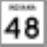
 Indiana State Road 48Indiana State Road 48State Road 48 in the U.S. State of Indiana is an east–west state highway running through southern Indiana. It has three distinct and separate sections. The western terminus of SR 48 is at State Road 63 and the eastern terminus at U.S. Route 50.- Western section :The western section...
 -
 Indiana State Road 59Indiana State Road 59State Road 59 is a north–south road in Central Indiana that covers a distance of about through five counties.-Route description:State Road 59 begins at State Road 58 and heads north towards Sandborn. In Sandborn SR 59 has intersection with State Road 67...
 -
 Indiana State Road 159Indiana State Road 159-Southern section:The southern section begins at State Road 67 at Bicknell and ends at State Road 58 in Freelandville, to the north.-Middle section:The middle section begins at Pleasantville and ends at State Road 54 at Dugger, to the north.-Northern section:...
 -
 Indiana State Road 246Indiana State Road 246State Road 246 is an east–west road in the southwest portion of the U.S. state of Indiana.-Route description:State Road 246 begins in the small town of Prairie Creek at State Road 63. Going east, it crosses U.S. Route 41 just north of Farmersburg...