
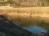
Levisa Fork River
Encyclopedia
The Levisa Fork is a tributary of the Big Sandy River
, approximately 164 miles (263.9 km) long, in southwestern Virginia
and eastern Kentucky
in the United States
.
It rises in the Appalachian Mountains
of southwestern Virginia
, in eastern Buchanan County
, near Grundy
. It flows west into Pike County, Kentucky
, where it receives the Russell Fork and is impounded to form Fishtrap Lake
reservoir, then northwest past Pikeville
and Prestonsburg
. The natural course of the river formed a loop surrounding downtown Pikeville, but a massive earthmoving project
completed in 1987 rerouted the river to bypass the city. At Paintsville
it turns to the north-northeast, flowing through Johnson
and Lawrence
counties. It joins the Tug Fork from the southwest at Louisa
on the West Virginia
state line to form the Big Sandy.
The river is partly navigable for commercial purposes through a series of locks
. In the early 1900s the river was navigable as far as Pikeville.
Variant names, according to the USGS, include Louisa River, Louisa Fork, Lavisa Fork, and West Fork, in addition to Levisa Fork River and Levisa Fork of the Big Sandy River. The official name according to the USGS is Levisa Fork. According to Robert F. Collins of the United States Forest Service
, Dr. Thomas Walker
had named the nearby Kentucky River
the Louisa River, after Princess Louisa, sister of Prince William Augustus, Duke of Cumberland
(Walker had just named the Cumberland River
a month or two earlier). According to George R. Stewart
, frontiersmen "forgot" who it was named for and it changed over time to Levisa.
Big Sandy River (Ohio River)
The Big Sandy River is a tributary of the Ohio River, approximately long, in western West Virginia and northeastern Kentucky in the United States. The river forms part of the boundary between the two states along its entire course...
, approximately 164 miles (263.9 km) long, in southwestern Virginia
Virginia
The Commonwealth of Virginia , is a U.S. state on the Atlantic Coast of the Southern United States. Virginia is nicknamed the "Old Dominion" and sometimes the "Mother of Presidents" after the eight U.S. presidents born there...
and eastern Kentucky
Kentucky
The Commonwealth of Kentucky is a state located in the East Central United States of America. As classified by the United States Census Bureau, Kentucky is a Southern state, more specifically in the East South Central region. Kentucky is one of four U.S. states constituted as a commonwealth...
in the United States
United States
The United States of America is a federal constitutional republic comprising fifty states and a federal district...
.
It rises in the Appalachian Mountains
Appalachian Mountains
The Appalachian Mountains #Whether the stressed vowel is or ,#Whether the "ch" is pronounced as a fricative or an affricate , and#Whether the final vowel is the monophthong or the diphthong .), often called the Appalachians, are a system of mountains in eastern North America. The Appalachians...
of southwestern Virginia
Southwest Virginia
Southwest Virginia, often abbreviated as SWVA, is a mountainous region of Virginia in the westernmost part of the commonwealth. Southwest Virginia has been defined alternatively as all Virginia counties on the Appalachian Plateau, all Virginia counties west of the Eastern Continental Divide, or...
, in eastern Buchanan County
Buchanan County, Virginia
As of the census of 2000, there were 26,978 people, 10,464 households, and 7,900 families residing in the county. The population density was 54 people per square mile . There were 11,887 housing units at an average density of 24 per square mile...
, near Grundy
Grundy, Virginia
Grundy is a town in Buchanan County, Virginia, United States. The population was 1,105 at the 2000 census. It is the county seat of Buchanan County. The town is noted for its educational institutions and their role in the town's economic rebirth. In the past, the town served as a stopover for Union...
. It flows west into Pike County, Kentucky
Pike County, Kentucky
Pike County is a county located in the U.S. state of Kentucky. As of 2010, the population was 65,024. Its county seat is Pikeville. Pike is Kentucky's largest county in terms of land area. Pike County is the 11th largest county in Kentucky in terms of population preceded by Bullitt County and...
, where it receives the Russell Fork and is impounded to form Fishtrap Lake
Fishtrap Lake
Fishtrap Lake is a reservoir in Pike County, Kentucky. Dedicated by President Lyndon B. Johnson in 1968, The lake was formed by the impounding of the Levisa Fork of the Big Sandy River at Fishtrap Dam by the United States Army Corps of Engineers....
reservoir, then northwest past Pikeville
Pikeville, Kentucky
Pikeville is a city in Pike County, Kentucky. The population was 6,903 at the 2010 census. It is the county seat of Pike County.-History:On March 25, 1822, the county's government officials decided to build a new county seat named Liberty, one and one-half mile below the mouth of the Russell Fork...
and Prestonsburg
Prestonsburg, Kentucky
Prestonsburg is a city in and the county seat of Floyd County, Kentucky, United States. It lies in the eastern part of the state, along the banks of the Levisa Fork of the Big Sandy River. It was founded in 1797 by Col. John Preston—for whom it was named—along with Solomon Stratton, Matthias...
. The natural course of the river formed a loop surrounding downtown Pikeville, but a massive earthmoving project
Pikeville Cut-Through
The Pikeville Cut-Through is a rock cut in Pikeville, Kentucky, United States created by the Army Corps of Engineers, through which passes a four-lane divided highway , a railroad line , and the Levisa Fork of the Big Sandy River...
completed in 1987 rerouted the river to bypass the city. At Paintsville
Paintsville, Kentucky
-Demographics:As of the census of 2000, there were 4,132 people, 1,681 households, and 1,079 families residing in the city. The population density was 786.1 people per square mile . There were 1,901 housing units at an average density of 361.7 per square mile...
it turns to the north-northeast, flowing through Johnson
Johnson County, Kentucky
Johnson County is a county located in the U.S. state of Kentucky. It was formed in 1843. As of 2000, the population was 23,445. Its county seat is Paintsville...
and Lawrence
Lawrence County, Kentucky
Lawrence County is a county located in the U.S. state of Kentucky. As of 2000, the population was 15,569. Its county seat is Louisa. The county is named for James Lawrence, and co-founded by Isaac Bolt, who served as a Lawrence County Commissioner and Justice of the Peace. It is the home of...
counties. It joins the Tug Fork from the southwest at Louisa
Louisa, Kentucky
Louisa is a city in Lawrence County, Kentucky, United States. The population was 2,018 at the 2000 census. It is the county seat of Lawrence County. The Levisa Fork River and Tug Fork River join at Louisa to form the Big Sandy River...
on the West Virginia
West Virginia
West Virginia is a state in the Appalachian and Southeastern regions of the United States, bordered by Virginia to the southeast, Kentucky to the southwest, Ohio to the northwest, Pennsylvania to the northeast and Maryland to the east...
state line to form the Big Sandy.
The river is partly navigable for commercial purposes through a series of locks
Lock (water transport)
A lock is a device for raising and lowering boats between stretches of water of different levels on river and canal waterways. The distinguishing feature of a lock is a fixed chamber in which the water level can be varied; whereas in a caisson lock, a boat lift, or on a canal inclined plane, it is...
. In the early 1900s the river was navigable as far as Pikeville.
Variant names, according to the USGS, include Louisa River, Louisa Fork, Lavisa Fork, and West Fork, in addition to Levisa Fork River and Levisa Fork of the Big Sandy River. The official name according to the USGS is Levisa Fork. According to Robert F. Collins of the United States Forest Service
United States Forest Service
The United States Forest Service is an agency of the United States Department of Agriculture that administers the nation's 155 national forests and 20 national grasslands, which encompass...
, Dr. Thomas Walker
Thomas Walker (explorer)
Dr. Thomas Walker was a physician and explorer from Virginia who led an expedition to what is now the region beyond the Allegheny Mountains area of British North America in the mid-18th century...
had named the nearby Kentucky River
Kentucky River
The Kentucky River is a tributary of the Ohio River, long, in the U.S. state of Kentucky. The river and its tributaries drain much of the central region of the state, with its upper course passing through the coal-mining regions of the Cumberland Mountains, and its lower course passing through the...
the Louisa River, after Princess Louisa, sister of Prince William Augustus, Duke of Cumberland
Prince William Augustus, Duke of Cumberland
Prince William , was a younger son of George II of Great Britain and Caroline of Ansbach, and Duke of Cumberland from 1726. He is generally best remembered for his role in putting down the Jacobite Rising at the Battle of Culloden in 1746, and as such is also known as "Butcher" Cumberland...
(Walker had just named the Cumberland River
Cumberland River
The Cumberland River is a waterway in the Southern United States. It is long. It starts in Harlan County in far southeastern Kentucky between Pine and Cumberland mountains, flows through southern Kentucky, crosses into northern Tennessee, and then curves back up into western Kentucky before...
a month or two earlier). According to George R. Stewart
George R. Stewart
George Rippey Stewart was an American toponymist, a novelist, and a professor of English at the University of California, Berkeley...
, frontiersmen "forgot" who it was named for and it changed over time to Levisa.