

Leschenault Estuary
Encyclopedia
Bunbury, Western Australia
The port city of Bunbury is the third largest city in Western Australia after the State Capital Perth and Mandurah. It is situated south of Perth's central business district...
.
It had in the past met the Indian Ocean
Indian Ocean
The Indian Ocean is the third largest of the world's oceanic divisions, covering approximately 20% of the water on the Earth's surface. It is bounded on the north by the Indian Subcontinent and Arabian Peninsula ; on the west by eastern Africa; on the east by Indochina, the Sunda Islands, and...
at the Leschenault Inlet - but that has been altered by harbour works for Bunbury, and the creation of The Cut north of the historical inlet location.
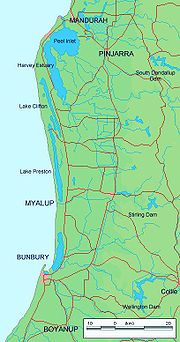
The estuary is approximately 13.5 km (8.4 mi) in length and has a maximum width of approximately 2.5 km (1.6 mi). The total area of the estuary is 25 km² (9.7 sq mi) The lagoon is separated from the ocean by a thin peninsula of sand dunes called the Leschenault Peninsula.
Catchment
The catchment area below Wellington Dam for the estuary covers 1981 km² (764.9 sq mi).The catchment includes part of the Swan Coastal Plain
Swan Coastal Plain
The Swan Coastal Plain in Western Australia is the geographic feature which contains the Swan River as it travels west to the Indian Ocean. The coastal plain continues well beyond the boundaries of the Swan River and its tributaries, as a geological and biological zone, one of Western Australia's...
, the Darling Scarp
Darling Scarp
The Darling Scarp, also referred to as the Darling Range or Darling Ranges, is a low escarpment running north-south to the east of the Swan Coastal Plain and Perth, Western Australia...
and the Darling Plateau.
The Collie
Collie River
The Collie River is a river in the South West region of Western Australia.The river was named after Dr Alexander Collie who, along with Lt. William Preston, was the first European explorer to find the river in 1829....
and Preston River
Preston River
The Preston River is a river in the South West region of Western Australia.The river has a total length of and rises near Goonac siding then flows in a North Westerly direction until discharging into the Leschenault Estuary....
s are the main catchment rivers and enter the estuary from the southern end and with the catchment runoff discharging into the Indian ocean
Indian Ocean
The Indian Ocean is the third largest of the world's oceanic divisions, covering approximately 20% of the water on the Earth's surface. It is bounded on the north by the Indian Subcontinent and Arabian Peninsula ; on the west by eastern Africa; on the east by Indochina, the Sunda Islands, and...
via the cut in the peninsula.
Other rivers in the catchment area include the Brunswick River
Brunswick River (Western Australia)
Brunswick River is a river in the South West region of Western Australia.The river rises in the Darling Range then flows south west discharging into the Collie River near Australind....
, Ferguson and Wellesley as well as numerous other creeks, streams and irrigation drains.
Seven local government areas are located within the catchment including Bunbury
City of Bunbury
The City of Bunbury is a Local Government Area in the South West region of Western Australia, covering an area of along the coast about south of Perth, the capital of Western Australia. The council is responsible for just over half of the Greater Bunbury metropolitan area, and the Port of Bunbury...
, Collie
Shire of Collie
The Shire of Collie is a Local Government Area in the South West region of Western Australia, about east of Bunbury and about south of the state capital, Perth...
, Capel
Shire of Capel
The Shire of Capel is a Local Government Area in the South West region of Western Australia, taking in the land between the cities of Bunbury and Busselton about south of the state capital, Perth. The Shire covers an area of , and its seat of government is the town of Capel...
, Dardanup
Shire of Dardanup
The Shire of Dardanup is a Local Government Area in the South West region of Western Australia, immediately to the east and southeast of the city of Bunbury and about south of the state capital, Perth. The Shire covers an area of , and its seat of government is in Eaton in Bunbury's eastern...
, Harvey
Shire of Harvey
The Shire of Harvey is a Local Government Area of Western Australia. It is located in the state's South West region, approximately 140km south of Perth, and includes some of Bunbury's northern suburbs. The shire covers an area of 1,728 km² and has a estimated population of about 24,000...
, Donnybrook-Balingup and Boyup Brook
Shire of Boyup Brook
The Shire of Boyup Brook is a Local Government Area located in the South West region of Western Australia, about southeast of Perth, the state capital. The Shire covers an area of and its seat of government is the town of Boyup Brook.-History:...
. The catchment has a total population of approximately 65,000 people.
The catchment area retains 40% of its natural vegetation
Vegetation
Vegetation is a general term for the plant life of a region; it refers to the ground cover provided by plants. It is a general term, without specific reference to particular taxa, life forms, structure, spatial extent, or any other specific botanical or geographic characteristics. It is broader...
, the remainder of the area has been cleared mostly for agricultural
Agriculture
Agriculture is the cultivation of animals, plants, fungi and other life forms for food, fiber, and other products used to sustain life. Agriculture was the key implement in the rise of sedentary human civilization, whereby farming of domesticated species created food surpluses that nurtured the...
purposes with some light industry.
History
The sand dune system responsible for the formation of the estuary began about 7,000 years ago. At this time the coast section between Mandurah and Bunbury was an open rocky limestoneLimestone
Limestone is a sedimentary rock composed largely of the minerals calcite and aragonite, which are different crystal forms of calcium carbonate . Many limestones are composed from skeletal fragments of marine organisms such as coral or foraminifera....
shore. A dune system began to build on the shore forming a long barred estuarine lagoon between the current estuary as far north as Lake Preston and effectively separated the lagoon from the ocean.
About 4,500 years ago the dune system met up with the eastern shore of the estuary separating the lagoon into two sections. The northern portion filled with mud leaving the southern section as the estuary that exists today.
Construction of the 'Cut', which opens the estuary into the ocean opposite the Collie River mouth, commenced in February 1950.
Flora and fauna
A white mangroveAvicennia marina
Avicennia marina, commonly known as grey mangrove or white mangrove, is a species of mangrove tree classified in the plant family Acanthaceae...
colony exists within the estuary, the colony are the most southern mangroves in Western Australia and are believed to be 2500 years old. The mangroves inhabit an area of 6.4 ha (15.8 acre). A boardwalk with informative signage has been constructed around the Mangrove colony so that visitors can inspect the area.
Waterbirds depend on the area for as habitat, up to 62 species of waterbird use the estuary, mostly feeding in the tidal salt-marshes.
The estuary is also an important fish nursery area.
Further reading
- Brearley, Anne Ernest Hodgkin's Swanland:estuaries and coastal lagoons of Southwestern Australia Crawley, Western Australia. University of Western Australia Press. ISBN 1-920694-38-2
See also
- Leschenault, Western AustraliaLeschenault, Western AustraliaLeschenault is an outer suburb of Bunbury, Western Australia, and is located 16 km to the north-east. Its Local Government Area is the Shire of Harvey.-History:...