

Leavitt Peak
Encyclopedia
Emigrant Wilderness
The Emigrant Wilderness of Stanislaus National Forest is a wilderness area in the Sierra Nevada mountains of California, USA. It is bordered by Yosemite National Park on the south, the Toiyabe National Forest on the east, and State Route 108 on the north. It is an elongated area that extends...
near Sonora Pass
Sonora Pass
Sonora Pass is the second-highest highway pass in the Sierra Nevada, lower by 321 ft. than Tioga Pass to the south. State Route 108 traverses the pass.-Description:...
in the eastern Sierra Nevada range of California
California
California is a state located on the West Coast of the United States. It is by far the most populous U.S. state, and the third-largest by land area...
. Leavitt Peak is located on the Tuolumne County
Tuolumne County, California
Tuolumne County is a county in the Sierra Nevada of the U.S. state of California. The northern half of Yosemite National Park is located in the eastern part of the county. As of the 2010 census, the population was 55,365, up from 54,501 at the 2000 census...
- Mono County
Mono County, California
Mono County is a county located in the east central portion of the U.S. state of California, to the east of the Sierra Nevada between Yosemite National Park and Nevada. As of the 2010 census, the population was 14,202, up from 12,853 at the 2000 census...
line. The Pacific Crest Trail
Pacific Crest Trail
The Pacific Crest Trail is a long-distance mountain hiking and equestrian trail on the Western Seaboard of the United States. The southern terminus is at the California border with Mexico...
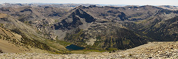
runs close to the east of Leavitt Peak, at an elevation of about 10800 foot elevation. The peak offers views south to Yosemite National Park
Yosemite National Park
Yosemite National Park is a United States National Park spanning eastern portions of Tuolumne, Mariposa and Madera counties in east central California, United States. The park covers an area of and reaches across the western slopes of the Sierra Nevada mountain chain...
and north towards South Lake Tahoe
Lake Tahoe
Lake Tahoe is a large freshwater lake in the Sierra Nevada of the United States. At a surface elevation of , it is located along the border between California and Nevada, west of Carson City. Lake Tahoe is the largest alpine lake in North America. Its depth is , making it the USA's second-deepest...
.
Leavitt Peak is named for Hiram Leavitt
Hiram Leavitt
Hiram Leavitt was an early settler, innkeeper, and judge in Mono County, California, in the eastern Sierra Nevada. Leavitt left his mark in the area and is the namesake of features such as Leavitt Peak, Leavitt Meadow, Leavitt Creek and Leavitt Lake.-History:Hiram Lewis Leavitt was born in...
, a native of New Hampshire
New Hampshire
New Hampshire is a state in the New England region of the northeastern United States of America. The state was named after the southern English county of Hampshire. It is bordered by Massachusetts to the south, Vermont to the west, Maine and the Atlantic Ocean to the east, and the Canadian...
, who built a hotel and home in 1863 at the foot of the east end of Sonora Pass
to serve the growing number of travelers between Sonora
Sonora, California
Sonora is the county seat of Tuolumne County, California. As of the 2010 census, the city population was 4,903, up from 4,423 at the 2000 census. Sonora is the only incorporated community in Tuolumne County.-Geography:...
and Aurora, primarily miners headed to the gold mines at nearby Bodie
Bodie, California
Bodie is a ghost town in the Bodie Hills east of the Sierra Nevada mountain range in Mono County, California, United States, about 75 miles southeast of Lake Tahoe. It is located east-southeast of Bridgeport, at an elevation of 8379 feet . As Bodie Historic District, the U.S. Department of the...
. Leavitt also erected a stagecoach station at what is called Leavitt Station. Leavitt was an early judge in Mono County. Leavitt Peak is a popular hiking destination. Leavitt Lake and Leavitt Meadow are nearby along the West Walker River
West Walker River
The West Walker River is a tributary of the Walker River, approximately long, in eastern California and western Nevada in the United States. It drains part of the Sierra Nevada range along the California-Nevada border in the watershed of Walker Lake in the Great Basin.It rises from snowmelt in the...
and are also named for the early Leavitt family settlers. Leavitt's is recorded on Charles F. Hoffmann
Charles F. Hoffmann
Charles Frederick Hoffmann was a German-American topographer working in California U.S. from 1860 to 1880.-Life:Hoffmann was born in Frankfurt, Germany, 1838. After receiving an education in engineering, he emigrated to America. In 1857 he was topographer for Frederick Lander’s survey to the Rocky...
's map of 1873. and Levitt Peak appears on the Mining Bureau map of 1891.