

Lawrence West (TTC)
Encyclopedia
Lawrence West is a station on the Yonge–University–Spadina line of the subway system
in Toronto
, Ontario
, Canada
. It is located on William R. Allen Road at 655 Lawrence Avenue
West. It opened in 1978 in what was then the Borough of North York
. One of two Toronto Transit Commission
bus lines that provide regular service to Toronto Pearson International Airport
, the 58 Malton, originates from this station. In 2008, the Toronto Star
reported this station, along with Lansdowne, Kennedy, and Warden to be a "known problem area" in terms of crime in the subway system.
The installation of an elevator is underway to make the station wheelchair accessible
by late 2010.
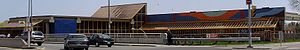
Dunlop Farrow Aitken was the firm responsible for the station's architecture. Lawrence West is located centrally in the median of Allen Road above ground. It is composed of an enclosed train platform area, which is bridged by a bus loop and waiting area. An entrance and transfer area link the train platform to the bus area and the street.
Upon entrance from the Lawrence Avenue bridge over Allen Road, the bus waiting area and the train platform are apparent. This openness is achieved through glazed walls and a large stairwell. The glass is framed with distinctive orange-painted metal. The platform level features exposed concrete walls, with a long strip of skylights above the tracks with the same orange framing used throughout the station. Rectangular prism benches with rectangular tiles of yellow, orange, and brown hues are unique to the station. Similar tiles are used on the floors and centre pillars.
The artwork Spacing... Aerial Highways by Claude Breeze
is located at the Lawrence Avenue entrance. The large 300 foot tile mural is visible from the street.
Toronto subway and RT
The Toronto subway and RT is a rapid transit system in Toronto, Ontario, Canada, consisting of both underground and elevated railway lines, operated by the Toronto Transit Commission . It was Canada's first completed subway system, with the first line being built under Yonge Street, which opened in...
in Toronto
Toronto
Toronto is the provincial capital of Ontario and the largest city in Canada. It is located in Southern Ontario on the northwestern shore of Lake Ontario. A relatively modern city, Toronto's history dates back to the late-18th century, when its land was first purchased by the British monarchy from...
, Ontario
Ontario
Ontario is a province of Canada, located in east-central Canada. It is Canada's most populous province and second largest in total area. It is home to the nation's most populous city, Toronto, and the nation's capital, Ottawa....
, Canada
Canada
Canada is a North American country consisting of ten provinces and three territories. Located in the northern part of the continent, it extends from the Atlantic Ocean in the east to the Pacific Ocean in the west, and northward into the Arctic Ocean...
. It is located on William R. Allen Road at 655 Lawrence Avenue
Lawrence Avenue
Lawrence Avenue is a major east-west thoroughfare in Toronto, Ontario, Canada. It is divided into east and west portions by Yonge Street, the dividing line of east-west streets in Toronto....
West. It opened in 1978 in what was then the Borough of North York
North York, Ontario
North York is a dissolved municipality within the current city of Toronto, Ontario, Canada. Geographically, it comprises the central part of the northern section of Toronto. As of the 2006 Census, it has a population of 635,370. The official 2001 census count was 608,288...
. One of two Toronto Transit Commission
Toronto Transit Commission
-Island Ferry:The ferry service to the Toronto Islands was operated by the TTC from 1927 until 1962, when it was transferred to the Metro Parks and Culture department. Since 1998, the ferry service is run by Toronto Parks and Recreation.-Gray Coach:...
bus lines that provide regular service to Toronto Pearson International Airport
Toronto Pearson International Airport
Toronto Pearson International Airport is an international airport serving Toronto, Ontario, Canada; its metropolitan area; and the Golden Horseshoe, an urban agglomeration that is home to 8.1 million people – approximately 25% of Canada's population...
, the 58 Malton, originates from this station. In 2008, the Toronto Star
Toronto Star
The Toronto Star is Canada's highest-circulation newspaper, based in Toronto, Ontario, Canada. Its print edition is distributed almost entirely within the province of Ontario...
reported this station, along with Lansdowne, Kennedy, and Warden to be a "known problem area" in terms of crime in the subway system.
The installation of an elevator is underway to make the station wheelchair accessible
Accessibility
Accessibility is a general term used to describe the degree to which a product, device, service, or environment is available to as many people as possible. Accessibility can be viewed as the "ability to access" and benefit from some system or entity...
by late 2010.
Entrances
The station's two entrances are located the north and south sides of the Lawrence Avenue bridge over Allen Road. Both station entrances allow access to staffed and automatic gates.Architecture and art
Dunlop Farrow Aitken was the firm responsible for the station's architecture. Lawrence West is located centrally in the median of Allen Road above ground. It is composed of an enclosed train platform area, which is bridged by a bus loop and waiting area. An entrance and transfer area link the train platform to the bus area and the street.
Upon entrance from the Lawrence Avenue bridge over Allen Road, the bus waiting area and the train platform are apparent. This openness is achieved through glazed walls and a large stairwell. The glass is framed with distinctive orange-painted metal. The platform level features exposed concrete walls, with a long strip of skylights above the tracks with the same orange framing used throughout the station. Rectangular prism benches with rectangular tiles of yellow, orange, and brown hues are unique to the station. Similar tiles are used on the floors and centre pillars.
The artwork Spacing... Aerial Highways by Claude Breeze
Claude Breeze
Claude Herbert Breeze is a Canadian artist and Professor Emeritus at York University in Toronto, Canada. He is also sometimes known as C. Herbert....
is located at the Lawrence Avenue entrance. The large 300 foot tile mural is visible from the street.
Nearby landmarks
- Columbus Centre
- Lawrence HeightsLawrence HeightsLawrence Heights is a neighbourhood in Toronto, Ontario, Canada. It is located north-west of central Toronto, in the district of North York. The neighbourhood is bounded by Lawrence Avenue to the south, Highway 401 to the north, Allen Road to the east and Dufferin Street to the west...
Community Recreation Centre - Lawrence Square Shopping CentreLawrence Square Shopping CentreThe Lawrence Square Shopping Centre in Toronto, Canada, is one of the city's twenty largest malls. It is located on Lawrence Avenue West, west of Allen Road, in the neighbourhood of Lawrence Heights, which is in Yorkdale-Glen Park, and is readily accessible from the Toronto Transit Commission's...
Surface connections
- Route 52: Lawrence West
- 52 to Martin Grove
- 52C to Culford
- 52W to Weston Rd (Lawrence & Pine)
- 352 Blue Night Lawrence West to Weston Rd
- Route 58: Malton to McNaughton - extra fare required west of Toronto Pearson International AirportToronto Pearson International AirportToronto Pearson International Airport is an international airport serving Toronto, Ontario, Canada; its metropolitan area; and the Golden Horseshoe, an urban agglomeration that is home to 8.1 million people – approximately 25% of Canada's population...
- Route 58: Malton to McNaughton - extra fare required west of Toronto Pearson International Airport
- 58A to Pearson Airport
- 58B to Westwood - extra fare required west of Airport
- 58C to Westwood via Pearson Airport - extra fare required west of Airport
- 58D to McNaughton via Pearson Airport - extra fare required west of Airport
- Route 59: Maple Leaf
- 59A to Weston Rd via Garry Drive
- 59B to Weston Rd via Church
- 59U to Weston Rd via Benton / Culford and Garry Dr.
- 59X to Weston Rd via Benton / Culford and Church
- Route 109: Ranee
- 109 to Neptune
- 109A to Neptune
- 109B to Neptune via Marlee & Flemington
- 109C to Neptune via Marlee & Varna
- 400 Lawrence Manor (Community Bus)