

Lava Tree State Monument
Encyclopedia
Puna, Hawaii
Puna is one of the nine districts in Hawaii County, Big Island, Hawaii. The District of Puna is located on the easternmost portion of the island and shares borders to the north with the District of South Hilo and a border to the west with the District of Kaū...
on the island of Hawaii
Hawaii (island)
The Island of Hawaii, also called the Big Island or Hawaii Island , is a volcanic island in the North Pacific Ocean...
.
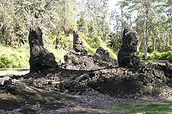
It preserves lava molds of the tree trunks that were formed when a lava
Lava
Lava refers both to molten rock expelled by a volcano during an eruption and the resulting rock after solidification and cooling. This molten rock is formed in the interior of some planets, including Earth, and some of their satellites. When first erupted from a volcanic vent, lava is a liquid at...
flow swept through a forested area in 1790.
Features
A 0.7 miles (1.1 km) foot path forms a loop through the park.Like all Hawaii state parks, there is no charge for parking and entry. Facilities include restrooms, picnic tables, and 3 covered structures to provide refuge from the rain or sun. It is open daily during daylight hours only, since there are no lights on the path.
No camping, and no mountain bikes are allowed in the park.
There are no water fountains at the park; bring your own.
Although there is a paved path, tree roots have lifted and separated parts of the path so toddlers and the elderly may need assistance.
Directions
From the Hawaii Belt Road (State Route 11), take Highway 130, known as Keaau-Pāhoa Road, toward the town of Pāhoa.Bypass the first intersection that would take you into Pāhoa by staying to the left. Continue to the traffic light where Pāhoa Bypass Road, Keaau-Pāhoa Rd and Pāhoa-Kapoho roads meet.
At this intersection, make a left onto Highway 132, Pāhoa-Kapoho Road.
Continue for about 3 miles (4.8 km) to Lava Tree Road on your left.
The park is located on your right, about 150 feet (45.7 m) down Lava Tree Road. Coordinates are 19°28′58"N 154°54′4"W.
History
The land was once part of the extensive ranch of William Herbert ShipmanWilliam Herbert Shipman
William Herbert Shipman was a wealthy businessman on the island of Hawaii. One estate of his family was used to preserve an endangered species of Hawaiian Goose. A historic house associated with his family for over a hundred years is called the W. H. Shipman House in Hilo, Hawaii...
.
Although ancient Hawaii
Ancient Hawaii
Ancient Hawaii refers to the period of Hawaiian human history preceding the unification of the Kingdom of Hawaii by Kamehameha the Great in 1810. After being first settled by Polynesian long-distance navigators sometime between AD 300–800, a unique culture developed. Diversified agroforestry and...
ans knew the molds were from a lava flow, one of the first to propose that they were from former trees was Rufus Anderson Lyman
Rufus Anderson Lyman
Rufus Anderson Lyman was a son of a missionary who became a lawyer and politician in the Kingdom of Hawaii, founded the Paauhau Sugar Plantation Company, and had many notable descendants.-Life:...
.
External links
- "Tree Molds" USGS Photo Glossary page
- Lava Tree State Park on Hawaiiweb.com