

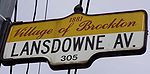
Lansdowne Avenue
Encyclopedia
Toronto
Toronto is the provincial capital of Ontario and the largest city in Canada. It is located in Southern Ontario on the northwestern shore of Lake Ontario. A relatively modern city, Toronto's history dates back to the late-18th century, when its land was first purchased by the British monarchy from...
, Ontario
Ontario
Ontario is a province of Canada, located in east-central Canada. It is Canada's most populous province and second largest in total area. It is home to the nation's most populous city, Toronto, and the nation's capital, Ottawa....
. It runs north-south and starts at Queen Street West
Queen Street West
Queen Street West describes both the western branch of Queen Street, a major east-west thoroughfare, and a series of neighbourhoods or commercial districts, situated west of Yonge Street in downtown Toronto, Ontario, Canada. Queen Street begins in the west at the intersection of King Street, The...
and proceeds north to St. Clair Avenue West
St. Clair Avenue
St. Clair Avenue is a major east-west street in Toronto, Ontario, Canada. It was laid out in the late 18th century by the British as a concession road , north of Bloor Street and north of Queen Street....
. Lansdowne Avenue is primarily a four-lane arterial road, with two lanes regularly used for motor vehicle parking.
Character
Lansdowne Avenue starts at Queen Street as a four-lane road in the ParkdaleParkdale, Toronto
Parkdale is a neighbourhood and former village in Toronto, Ontario, Canada, west of downtown. The neighbourhood is bounded on the west by Roncesvalles Avenue, on the north by Queen Street. It is bounded on the east by Dufferin Street from Queen Street south, and on the south by Lake Ontario...
neighbourhood. In the 2000s, the section from Queen to the CN/CPR tracks was narrowed for street calming. Both sides of the street are residential with some institutional uses, including a fire station, a park and a Community Centre. Starting at the rail tracks underpass the roadway widens to four lanes. On the west side is a former cash register factory, which was converted to a Knob Hill Farms
Knob Hill Farms
Knob Hill Farms was a supermarket chain in the Greater Toronto Area, Ontario, Canada. It was founded by Steve Stavro, and operated from 1951 to 2001.-Community grocery stores:...
store until it went out of business in 2000. The building was mostly demolished, leaving only the eastern facade, and a large 'No Frills
No Frills (grocery store)
No Frills is a chain of deep discount supermarkets in Canada, owned by Loblaw Companies Limited, a subsidiary of George Weston Limited...
' supermarket was built in its place which it remains today. On the east side are more semi-detached homes. The east side of the street is within the Little Portugal
Little Portugal, Toronto
Little Portugal is a neighbourhood and ethnic enclave in Toronto, Ontario, Canada. It is located west of downtown in the "Old" City of Toronto. It is bounded on the west by Lansdowne Avenue, on the north by College Street, on the east by Ossington Avenue and on the south by the CNR/CPR mainline...
neighbourhood.
College Street (Toronto)
College Street is a principal arterial thoroughfare in downtown Toronto, connecting former streetcar suburbs in the west with the city centre. The street is home to an ethnically diverse population in the western residential reaches, and institutions like the Ontario Legislature and the University...
, the street narrows again for street calming to three lanes until Bloor Street
Bloor Street
Bloor Street is a major east–west residential and commercial thoroughfare in Toronto, in the Canadian province of Ontario. Bloor Street runs from the Prince Edward Viaduct westward into Mississauga, where it ends at Central Parkway. East of the viaduct, Danforth Avenue continues along the same...
West. This stretch is completely residential on the east side, with West Toronto Collegiate
West Toronto Collegiate
West Toronto Collegiate ' is a former public high school in the Dufferin Grove neighbourhood in Toronto, Ontario, Canada. It is located at 330 Lansdowne Avenue, just north of College Street...
on the west side, a large high school. This area is within the Dufferin Grove
Dufferin Grove
Dufferin Grove is a neighbourhood located in Toronto, Ontario, Canada, west of downtown. The neighbourhood is bordered by Bloor Street West to the north, Ossington Ave to the east, College Street to the south, and Dufferin Street to the west.-Character:...
neighbourhood. The Bloor Street stretch here is known as 'Bloordale Village
Bloordale Village
Bloordale Village is a shopping and arts district in Toronto, Ontario, Canada. It is located along Bloor Street from Lansdowne Avenue to Dufferin Street, west of downtown Toronto...
.'
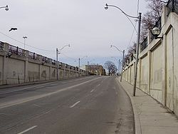
North of Bloor Street, the street is four lanes with parking, and is mixed uses of residential and retail storefronts until north of Emerson Avenue, and the cross-town CPR tracks
Canadian Pacific Railway
The Canadian Pacific Railway , formerly also known as CP Rail between 1968 and 1996, is a historic Canadian Class I railway founded in 1881 and now operated by Canadian Pacific Railway Limited, which began operations as legal owner in a corporate restructuring in 2001...
, where a large former industrial area exists. The buildings along this stretch have been converted to loft
Loft
A loft can be an upper story or attic in a building, directly under the roof. Alternatively, a loft apartment refers to large adaptable open space, often converted for residential use from some other use, often light industrial...
-style buildings up to Davenport Road. This area is known as Dovercourt-Wallace Emerson-Junction.
North of Davenport, Lansdowne climbs a steep hill, which was the former Lake Iroquois
Glacial Lake Iroquois
Glacial Lake Iroquois was a prehistoric proglacial lake that existed at the end of the last ice age approximately 13,000 years ago.The lake was essentially an enlargement of the present Lake Ontario that formed because the St. Lawrence River downstream from the lake was blocked by the ice sheet...
shoreline. Along the west side is Earlscourt Park, and the roadway curves around and alongside the Park. From here north to St. Clair, both sides of the street are residential.
The main section of the street ends in the Corso Italia neighbourhood at St. Clair Avenue West, a major east-west thoroughfare. Across the intersection is Prospect Cemetery.
In the block between Eglinton and Lawrence, there are two small, disconnected sections of Lansdowne which are roughly in line with the southern alignment of the street. The southernmost of these two sections (from Wingold Avenue to Glengrove Avenue) is also mixed residential and industrial, while the northernmost of the two sections (Glenlong Avenue to Playfair Avenue) is only one block long, and completely residential.
History
Lansdowne Avenue was built by the Village of Parkdale and named after the Marquis of Lansdowne, and Governor-General of Canada in 1883. The section from to north of Dupont was laid out in 1888 and was named Mackenzie Avenue, after William Innes Mackenzie, the secretary of the Toronto House Building Association. The section to the south of Davenport was first named Jubilee, then Malvern, according to the 1890 Atlas of Toronto. The various sections were renamed to Lansdowne in 1910 when the area was annexed by Toronto. The section north of Davenport was built after 1890 and was built on the estate of Allan Royce. The estate became Earlscourt Park.Public transit
Toronto buses and trolley buses
Toronto Transit Commission buses are transit buses used for public transport in Toronto, Ontario, Canada. Buses are owned and operated by the Toronto Transit Commission . With over 140 routes in operation, the TTC attracts over 400 million riders each year. Each route is further divided into branch...
, which runs the length of Lansdowne Avenue, as well as along Caledonia Road to Yorkdale station
Yorkdale (TTC)
Yorkdale is a station on the Yonge–University–Spadina line of the subway system in Toronto, Ontario, Canada. It is located on William R. Allen Road just south of Highway 401. It opened in 1978 in what was then the Borough of North York, and was named for the nearby Yorkdale Shopping Centre, to...
. The Lansdowne station
Lansdowne (TTC)
Lansdowne is a station on the Bloor–Danforth line of the subway system in Toronto, Canada. Its official address is 1287 Bloor Street West, although the main station is located just north of Bloor Street on Lansdowne Avenue. Opened in 1966, the station lies approximately 561 metres from its nearest...
on the Bloor-Danforth TTC
Toronto Transit Commission
-Island Ferry:The ferry service to the Toronto Islands was operated by the TTC from 1927 until 1962, when it was transferred to the Metro Parks and Culture department. Since 1998, the ferry service is run by Toronto Parks and Recreation.-Gray Coach:...
subway line
Toronto subway and RT
The Toronto subway and RT is a rapid transit system in Toronto, Ontario, Canada, consisting of both underground and elevated railway lines, operated by the Toronto Transit Commission . It was Canada's first completed subway system, with the first line being built under Yonge Street, which opened in...
is located on Lansdowne, just north of Bloor Street.
Streetcars used to operate on Lansdowne Avenue between St Clair Avenue West and Dundas Street West. In 1947, streetcars were replaced by trolley bus service. Trolley bus service was finally replaced by the existing 47 bus in 1992.