

College Street (Toronto)
Encyclopedia
College Street is a principal arterial thoroughfare in downtown Toronto
, connecting former streetcar suburbs in the west with the city centre
. The street is home to an ethnically diverse population in the western residential reaches, and institutions like the Ontario Legislature
and the University of Toronto
in the downtown core
. At Yonge Street
, College continues to the east as Carlton Street.
, originally King's College. Between Spadina Avenue and Yonge Street, College marks the southern boundary of the original 1827 land grant for the college. The street was immediately proposed as an east-west route along the boundary, although the section was not built until 1859. The first section built was to the west of Spadina Avenue, through the estate of Robert Baldwin
, who laid out the route. This section was built with the 100 feet (30.5 m) that was also used for Spadina. The section through Baldwin's estate was laid out in 1842, and the wide section was extended to Manning Avenue through the Denison and Crookshank estates.
After John Howard
made the 1873 land grant which would become High Park
, the Denison family proposed that the city extend College Street west as a sort of 'driving park' to access the new public lands. The path to the west of Manning Avenue was blocked by William Wakefield, who owned the land beyond and was holding out for a high sale price. The purchase of Wakefield's land did not take place until 1879. The right-of-way purchased through Wakefield's land was the standard 66 feet (20.1 m) width, rather than the 100 ft width to the east. The cost of the land may have been a factor.
Building the route west of Clinton Street
was a challenge in the 1880s. At the time, a direct line west would have traveled through the ravines of Garrison
and Brewery Creeks as far as Dufferin Street
, the western city limit at the time. Instead, the road was rerouted along a north-western crescent running parallel to the creeks. The route then proceeded straight as far west as Havelock Street, just east of Dufferin.
At Havelock Street, the right-of-way intersected the property of Charles Lindsay. The alignment of College Street would have bisected his property, leaving unsaleable lot sizes on the south side of College. Lindsay was able to convince the city to reroute around his property to the north, with a 'kink' that exists to this day.
After the suburb of Brockton
was annexed in the 1880s, the final section of College Street was built to Lansdowne Avenue
in 1886. It was expected that College would be extended further, but just west of Lansdowne the rail lines created a barrier. A pre-cursor to an extended College Street, called Grenadier Road, was laid out in the Roncesvalles district, and on the west side of High Park in Swansea (now Morningside) as well as a section in Etobicoke (now Berry Road), but connections to those streets were never made.
Streetcar service extended as far west as Dufferin by 1889, and (via Dundas Street) to High Park by 1893. Sunday operation of the line to High Park did not begin until 1897, after a city-wide plebiscite was held on the issue of Sunday streetcar operation. The streetcar led to the development of residential sub-divisions on both sides, with street frontages actually empty. The frontages were used for billboards, with development on the street only filling up the lots on both sides by World War I
, although some vacant lots existed into the 1920s.
 The intersection at Yonge Street
is dominated by the landmark College Park
complex, which once housed an Eaton's
department store
. This historic building is now used for retail, office, and residential purposes.
At University Avenue
, College traverses a major institutional district, with the Ontario Legislature
, the University of Toronto
, and the MaRS Discovery District
marking one of the city's most important and historic intersections. The district also features a concentration of teaching hospitals, including Toronto General Hospital
, the Hospital for Sick Children
, Princess Margaret Hospital
, Mount Sinai Hospital
, and Toronto Rehab.
Between University and Spadina Avenue
, the street bounds the Grange Park neighbourhood
to the south, a mixed-residential area with student housing and historic residences such as George Brown House. The intersection at Spadina Avenue represents the northern boundary of the city's principal Chinatown
, as well as the western boundary of the university. The intersection is marked by the focal point of 1 Spadina Crescent
in a roundabout
to the north, and a complex rail interchange where the busy 510 Spadina streetcar route, running on a dedicated right-of-way, meets the 506 Carlton route.
The section of College west of Spadina is home to a variety of computer stores, known as a destination for cheap computer parts. This stretch of College also forms the northern border of Kensington Market
.
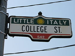
West of Bathurst Street, College is the heart of Toronto's Little Italy
and is dotted with restaurants and trendy bars. Further west, College is primarily residential.
's 506 Carlton streetcar route
runs along College and Carlton Streets. College is served by Queen's Park station
and College station
on the University
and Yonge
branches, respectively, of the Yonge-University-Spadina subway line.
Toronto
Toronto is the provincial capital of Ontario and the largest city in Canada. It is located in Southern Ontario on the northwestern shore of Lake Ontario. A relatively modern city, Toronto's history dates back to the late-18th century, when its land was first purchased by the British monarchy from...
, connecting former streetcar suburbs in the west with the city centre
Downtown Toronto
Downtown Toronto is the central business district of Toronto, Ontario, Canada. It is approximately bounded by Bloor Street to the north, Lake Ontario to the south, the Don River to the east, and Bathurst Street to the west...
. The street is home to an ethnically diverse population in the western residential reaches, and institutions like the Ontario Legislature
Legislative Assembly of Ontario
The Legislative Assembly of Ontario , is the legislature of the Canadian province of Ontario, and is the second largest provincial legislature of Canada...
and the University of Toronto
University of Toronto
The University of Toronto is a public research university in Toronto, Ontario, Canada, situated on the grounds that surround Queen's Park. It was founded by royal charter in 1827 as King's College, the first institution of higher learning in Upper Canada...
in the downtown core
Downtown Toronto
Downtown Toronto is the central business district of Toronto, Ontario, Canada. It is approximately bounded by Bloor Street to the north, Lake Ontario to the south, the Don River to the east, and Bathurst Street to the west...
. At Yonge Street
Yonge Street
Yonge Street is a major arterial route connecting the shores of Lake Ontario in Toronto to Lake Simcoe, a gateway to the Upper Great Lakes. It was formerly listed in the Guinness Book of Records as the longest street in the world at , and the construction of Yonge Street is designated an "Event of...
, College continues to the east as Carlton Street.
History
College Street takes its name from the University of TorontoUniversity of Toronto
The University of Toronto is a public research university in Toronto, Ontario, Canada, situated on the grounds that surround Queen's Park. It was founded by royal charter in 1827 as King's College, the first institution of higher learning in Upper Canada...
, originally King's College. Between Spadina Avenue and Yonge Street, College marks the southern boundary of the original 1827 land grant for the college. The street was immediately proposed as an east-west route along the boundary, although the section was not built until 1859. The first section built was to the west of Spadina Avenue, through the estate of Robert Baldwin
Robert Baldwin
Robert Baldwin was born at York . He, along with his political partner Louis-Hippolyte Lafontaine, led the first responsible ministry in Canada, regarded by some as the first truly Canadian government....
, who laid out the route. This section was built with the 100 feet (30.5 m) that was also used for Spadina. The section through Baldwin's estate was laid out in 1842, and the wide section was extended to Manning Avenue through the Denison and Crookshank estates.
After John Howard
John George Howard
John George Howard, born John Corby, was the City of Toronto, Canada's official surveyor and civil engineer...
made the 1873 land grant which would become High Park
High Park
High Park is a municipal park in Toronto, Ontario, Canada. It spans , and is a mixed recreational and natural park, with sporting facilities, cultural facilities, educational facilities, gardens, playgrounds and a zoo. One third of the park remains in a natural state, with a rare oak savannah ecology...
, the Denison family proposed that the city extend College Street west as a sort of 'driving park' to access the new public lands. The path to the west of Manning Avenue was blocked by William Wakefield, who owned the land beyond and was holding out for a high sale price. The purchase of Wakefield's land did not take place until 1879. The right-of-way purchased through Wakefield's land was the standard 66 feet (20.1 m) width, rather than the 100 ft width to the east. The cost of the land may have been a factor.
Building the route west of Clinton Street
Little Italy, Toronto
Little Italy, sometimes referred to as College Street West, is a district in Toronto, Ontario, Canada. It is well known for its numerous Italian Canadian restaurants and businesses. There is also a significant Latin American and Portuguese community in the area...
was a challenge in the 1880s. At the time, a direct line west would have traveled through the ravines of Garrison
Garrison Creek
Garrison Creek was a short stream about long that flowed southeast into the west side of Toronto Harbour in Ontario, Canada.It has been largely covered over and filled in, but geographical traces of the creek can still be found. The natural amphitheatre known as Christie Pits is one such remnant;...
and Brewery Creeks as far as Dufferin Street
Dufferin Street
Dufferin Street is a major north-south street in Toronto, Ontario, Canada. It is a concession road, two concessions west of Yonge Street. The street starts at the foot of Lake Ontario, continues north to Toronto's northern boundary with some discontinuities and continues into York Region where it...
, the western city limit at the time. Instead, the road was rerouted along a north-western crescent running parallel to the creeks. The route then proceeded straight as far west as Havelock Street, just east of Dufferin.
At Havelock Street, the right-of-way intersected the property of Charles Lindsay. The alignment of College Street would have bisected his property, leaving unsaleable lot sizes on the south side of College. Lindsay was able to convince the city to reroute around his property to the north, with a 'kink' that exists to this day.
After the suburb of Brockton
Brockton Village
Brockton Village is a neighbourhood in Toronto, Ontario, Canada. It comprises a section of the old Town of Brockton which was annexed by the City of Toronto in 1884. The town encompassed the area from Bloor Street on the north, Dufferin Street on the east, High Park on the west and ranged from...
was annexed in the 1880s, the final section of College Street was built to Lansdowne Avenue
Lansdowne Avenue
Lansdowne Avenue is an arterial road in Toronto, Ontario. It runs north-south and starts at Queen Street West and proceeds north to St. Clair Avenue West. Lansdowne Avenue is primarily a four-lane arterial road, with two lanes regularly used for motor vehicle parking.-Character:Lansdowne Avenue...
in 1886. It was expected that College would be extended further, but just west of Lansdowne the rail lines created a barrier. A pre-cursor to an extended College Street, called Grenadier Road, was laid out in the Roncesvalles district, and on the west side of High Park in Swansea (now Morningside) as well as a section in Etobicoke (now Berry Road), but connections to those streets were never made.
Streetcar service extended as far west as Dufferin by 1889, and (via Dundas Street) to High Park by 1893. Sunday operation of the line to High Park did not begin until 1897, after a city-wide plebiscite was held on the issue of Sunday streetcar operation. The streetcar led to the development of residential sub-divisions on both sides, with street frontages actually empty. The frontages were used for billboards, with development on the street only filling up the lots on both sides by World War I
World War I
World War I , which was predominantly called the World War or the Great War from its occurrence until 1939, and the First World War or World War I thereafter, was a major war centred in Europe that began on 28 July 1914 and lasted until 11 November 1918...
, although some vacant lots existed into the 1920s.
Route description
Yonge Street
Yonge Street is a major arterial route connecting the shores of Lake Ontario in Toronto to Lake Simcoe, a gateway to the Upper Great Lakes. It was formerly listed in the Guinness Book of Records as the longest street in the world at , and the construction of Yonge Street is designated an "Event of...
is dominated by the landmark College Park
College Park (Toronto)
College Park is a shopping mall, residential and office complex located on the southwest corner of Yonge Street and College Street in Toronto, Ontario, Canada...
complex, which once housed an Eaton's
Eaton's
The T. Eaton Co. Limited was once Canada's largest department store retailer. It was founded in 1869 in Toronto by Timothy Eaton, an Irish immigrant. Eaton's grew to become a retail and social institution in Canada, with stores across the country, buying offices across the globe, and a catalogue...
department store
Department store
A department store is a retail establishment which satisfies a wide range of the consumer's personal and residential durable goods product needs; and at the same time offering the consumer a choice of multiple merchandise lines, at variable price points, in all product categories...
. This historic building is now used for retail, office, and residential purposes.
At University Avenue
University Avenue (Toronto)
University Avenue is a major north-south road in Downtown Toronto, Ontario, Canada. At its north end, University Avenue is the site of the Ontario Legislative Building. The eight-lane wide street is the location for several hospitals, numerous office buildings, Osgoode Hall and the Four Seasons...
, College traverses a major institutional district, with the Ontario Legislature
Legislative Assembly of Ontario
The Legislative Assembly of Ontario , is the legislature of the Canadian province of Ontario, and is the second largest provincial legislature of Canada...
, the University of Toronto
University of Toronto
The University of Toronto is a public research university in Toronto, Ontario, Canada, situated on the grounds that surround Queen's Park. It was founded by royal charter in 1827 as King's College, the first institution of higher learning in Upper Canada...
, and the MaRS Discovery District
MaRS Discovery District
MaRS Discovery District is a not-for-profit corporation founded in Toronto in 2000. Its stated goal is to commercialize publicly funded medical research with the help of local private enterprises and as such is a public-private partnership....
marking one of the city's most important and historic intersections. The district also features a concentration of teaching hospitals, including Toronto General Hospital
Toronto General Hospital
The Toronto General Hospital , is a part of the University Health Network, and a major teaching hospital in downtown Toronto, Ontario. It is located in the Discovery District, directly north of the Hospital for Sick Children, across Gerrard Street West, and east of Princess Margaret Hospital and...
, the Hospital for Sick Children
Hospital for Sick Children
The Hospital for Sick Children – is a major paediatric centre for the Greater Toronto Area, serving patients up to age 18. Located on University Avenue in Downtown Toronto, SickKids is part of the city’s Discovery District, a critical mass of scientists and entrepreneurs who are focused on...
, Princess Margaret Hospital
Princess Margaret Hospital (Toronto)
Princess Margaret Hospital is located in downtown Toronto, Ontario, Canada on University Avenue at College Street. It is part of the University Health Network...
, Mount Sinai Hospital
Mount Sinai Hospital (Toronto)
Mount Sinai Hospital is a hospital in Toronto, Ontario, Canada. Although it is physically linked by bridges and tunnels to two University Health Network hospitals , Mount Sinai is an independently operated facility...
, and Toronto Rehab.
Between University and Spadina Avenue
Spadina Avenue
Spadina Avenue is one of the most prominent streets in Toronto, Ontario, Canada. Running through the western section of downtown, the road has a very different character in different neighbourhoods....
, the street bounds the Grange Park neighbourhood
Grange Park (neighbourhood)
Grange Park is a neighbourhood in downtown Toronto, Ontario, Canada. It is bounded on the west by Spadina Avenue, on the north by College Street, on the east by University Avenue and on the south by Queen Street. It is within the 'Kensington-Chinatown' City of Toronto planning neighbourhood. Its...
to the south, a mixed-residential area with student housing and historic residences such as George Brown House. The intersection at Spadina Avenue represents the northern boundary of the city's principal Chinatown
Chinatown, Toronto
Chinatown is an ethnic enclave in Downtown Toronto, Ontario, Canada, with a high concentration of ethnic Chinese residents and businesses extending along Dundas Street West and Spadina Avenue. First developed in the late 19th century, it is now one of the largest Chinatowns in North America and...
, as well as the western boundary of the university. The intersection is marked by the focal point of 1 Spadina Crescent
1 Spadina Crescent
1 Spadina Crescent is an academic building of the University of Toronto in Toronto, Ontario, Canada, situated in the centre of a roundabout of Spadina Avenue, north of College Street. Its location provides a picturesque vista looking north up Spadina Avenue; it is an axial view terminus for Spadina...
in a roundabout
Roundabout
A roundabout is the name for a road junction in which traffic moves in one direction around a central island. The word dates from the early 20th century. Roundabouts are common in many countries around the world...
to the north, and a complex rail interchange where the busy 510 Spadina streetcar route, running on a dedicated right-of-way, meets the 506 Carlton route.
The section of College west of Spadina is home to a variety of computer stores, known as a destination for cheap computer parts. This stretch of College also forms the northern border of Kensington Market
Kensington Market
Kensington Market is a distinctive multicultural neighbourhood in Downtown Toronto, Ontario, Canada. The Market is an older neighbourhood and one of the city's most well-known. In November 2006, it was designated a National Historic Site of Canada. Robert Fulford wrote in 1999 that "Kensington...
.
West of Bathurst Street, College is the heart of Toronto's Little Italy
Little Italy, Toronto
Little Italy, sometimes referred to as College Street West, is a district in Toronto, Ontario, Canada. It is well known for its numerous Italian Canadian restaurants and businesses. There is also a significant Latin American and Portuguese community in the area...
and is dotted with restaurants and trendy bars. Further west, College is primarily residential.
Public transit
The TTCToronto Transit Commission
-Island Ferry:The ferry service to the Toronto Islands was operated by the TTC from 1927 until 1962, when it was transferred to the Metro Parks and Culture department. Since 1998, the ferry service is run by Toronto Parks and Recreation.-Gray Coach:...
's 506 Carlton streetcar route
Toronto streetcar system
The Toronto streetcar system comprises eleven streetcar routes in Toronto, Ontario, Canada, operated by the Toronto Transit Commission , and is the largest such system in the Americas in terms of ridership, number of cars, and track length. The network is concentrated primarily in downtown and in...
runs along College and Carlton Streets. College is served by Queen's Park station
Queen's Park (TTC)
Queen's Park is a station on the Yonge–University–Spadina line of the subway system in Toronto, Ontario, Canada. Located at 671 University Avenue at College Street, the station opened in 1963....
and College station
College (TTC)
College is a subway station on the Yonge–University–Spadina line of the Toronto, Ontario, Canada subway that opened in 1954. It is located at 448 Yonge Street at College Street/Carlton Street.-Entrances:...
on the University
University Avenue
-Canada:*University Avenue *University Avenue *University Avenue *University Avenue *University Avenue *University Street, Montreal-United States:...
and Yonge
Yonge Street
Yonge Street is a major arterial route connecting the shores of Lake Ontario in Toronto to Lake Simcoe, a gateway to the Upper Great Lakes. It was formerly listed in the Guinness Book of Records as the longest street in the world at , and the construction of Yonge Street is designated an "Event of...
branches, respectively, of the Yonge-University-Spadina subway line.
Major intersection
The following is a list of major intersections along College Street- Dundas StreetDundas StreetDundas Street, also known as Highway 5 west of Toronto, is a major arterial road connecting the centre of that city with its western suburbs and southwestern Ontario beyond...
- Lansdowne AvenueLansdowne AvenueLansdowne Avenue is an arterial road in Toronto, Ontario. It runs north-south and starts at Queen Street West and proceeds north to St. Clair Avenue West. Lansdowne Avenue is primarily a four-lane arterial road, with two lanes regularly used for motor vehicle parking.-Character:Lansdowne Avenue...
- Ossington AvenueOssington AvenueOssington Avenue is a main or arterial street in Toronto, Ontario, Canada, west of downtown. Originally part of a pioneer road built in 1812, it became an arterial road. Today it is becoming a night-life district with numerous bars and restaurants.-History:...
- Bathurst StreetBathurst Street (Toronto)Bathurst Street is a main north-south thoroughfare in Toronto. It begins at the Lake Ontario shoreline and continues north to the Toronto boundary of Steeles Avenue...
- Spadina AvenueSpadina AvenueSpadina Avenue is one of the most prominent streets in Toronto, Ontario, Canada. Running through the western section of downtown, the road has a very different character in different neighbourhoods....
- University AvenueUniversity Avenue (Toronto)University Avenue is a major north-south road in Downtown Toronto, Ontario, Canada. At its north end, University Avenue is the site of the Ontario Legislative Building. The eight-lane wide street is the location for several hospitals, numerous office buildings, Osgoode Hall and the Four Seasons...
(south) / Queen's ParkQueen's ParkThere are a number of places in the world called Queen's Park or Queens Park.- Australia :* Queens Park, New South Wales, suburb* Queens Park, Victoria ** Queens Park, Newtown, Victoria Queen's Park Golf Course...
Crescent (north) - Bay StreetBay StreetBay Street, originally known as Bear Street, is a major thoroughfare in Downtown Toronto. It is the centre of Toronto's Financial District and is often used by metonymy to refer to Canada's financial industry since succeeding Montreal's St. James Street in that role in the 1970s...
- Yonge StreetYonge StreetYonge Street is a major arterial route connecting the shores of Lake Ontario in Toronto to Lake Simcoe, a gateway to the Upper Great Lakes. It was formerly listed in the Guinness Book of Records as the longest street in the world at , and the construction of Yonge Street is designated an "Event of...